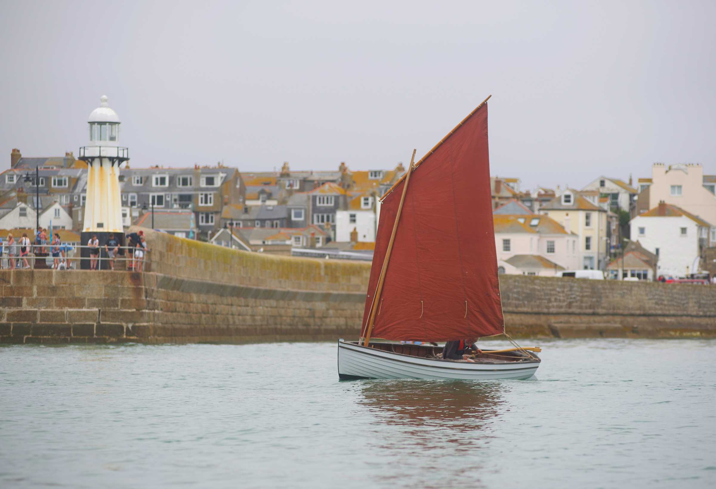
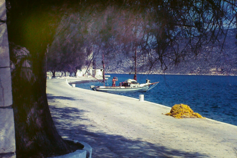
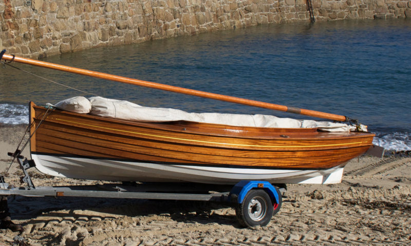
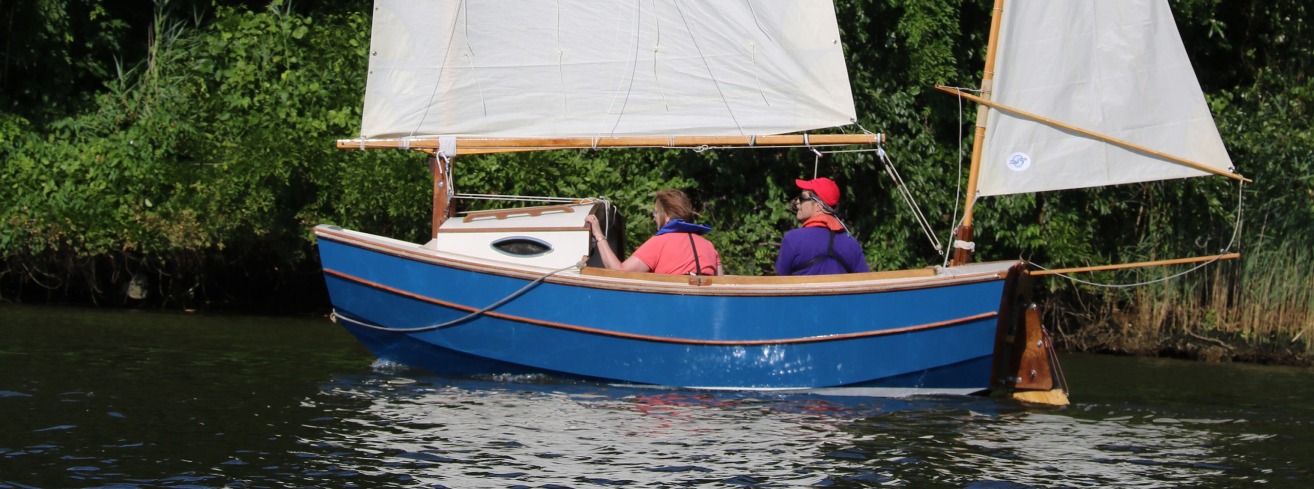
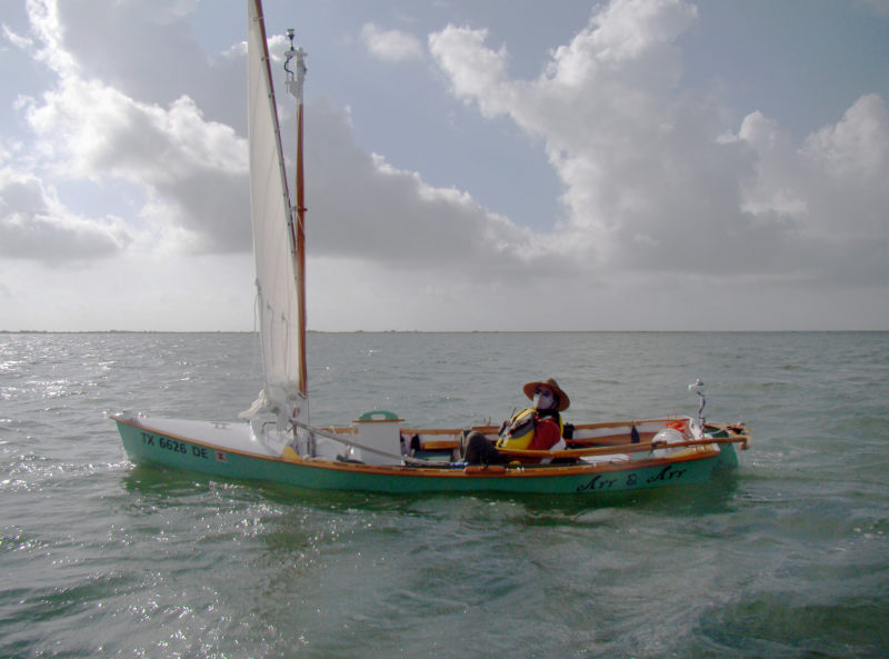
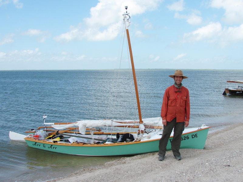
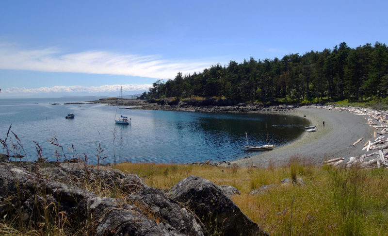
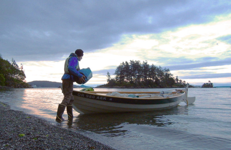
Long before the fine sand and exquisite light of St. Ives were discovered by artists and tourists, the small town on the north coast of Cornwall was a thriving fishing center. At its peak, 300 fishing boats were moored cheek by jowl inside its picturesque harbor and millions of fish were landed, salted, and then exported all over Europe. Each of these boats had a tender and, as the tide went out, each tender had to settle on the sand until it was refloated by the incoming tide, twice a day, every day. Most days, the boats were given a good beating by the notorious ground sea that runs into the harbor, and on bad days they often got swamped and filled with sand. It’s a particular kind of punishment that requires a certain type of boat, as retired physician Scott Bowring discovered.
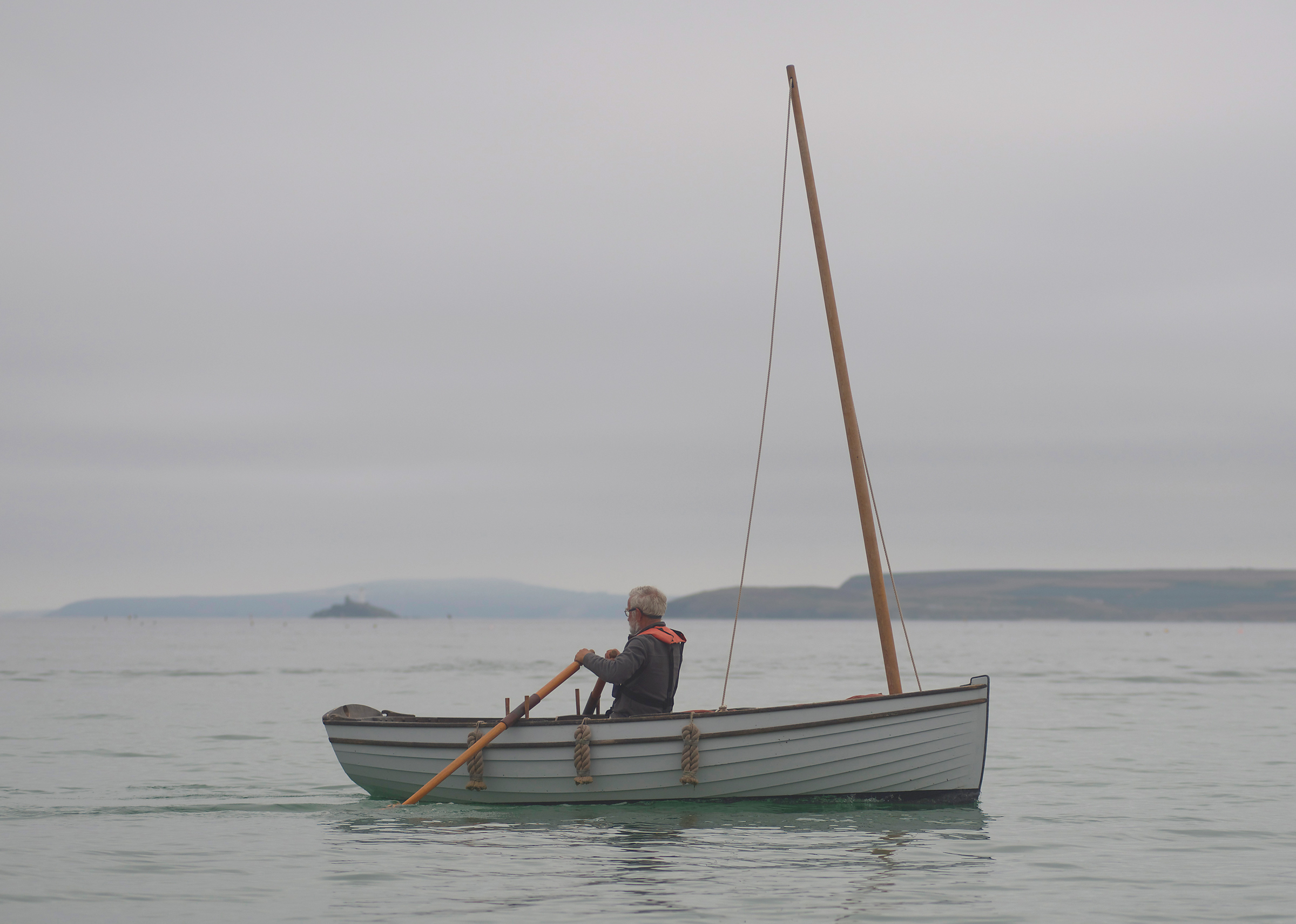
“When I started sailing in St. Ives 12 years ago, I wanted a boat to keep in the harbor, so I had a 10′6″ Lily-class dinghy built for me by Ashley Butler in Dartmouth,” Scott says. “ZEPHYR is a lovely boat, and I’ve had loads of fun on her, but she was too lightly built for the conditions in St. Ives, and at the end of every season, a couple of ribs would be broken. I realized I needed something stronger for the conditions here.”
Photographs by the author
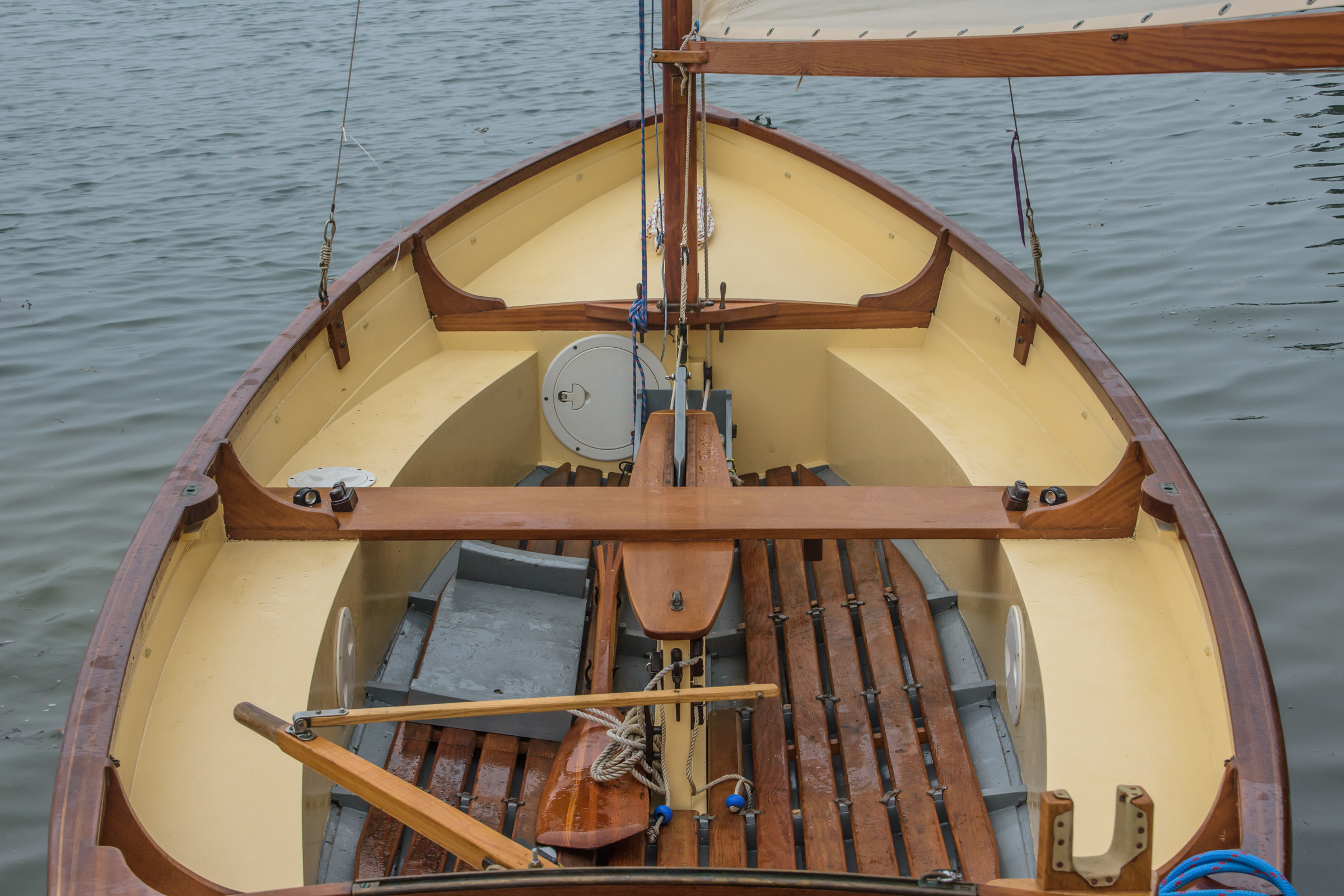
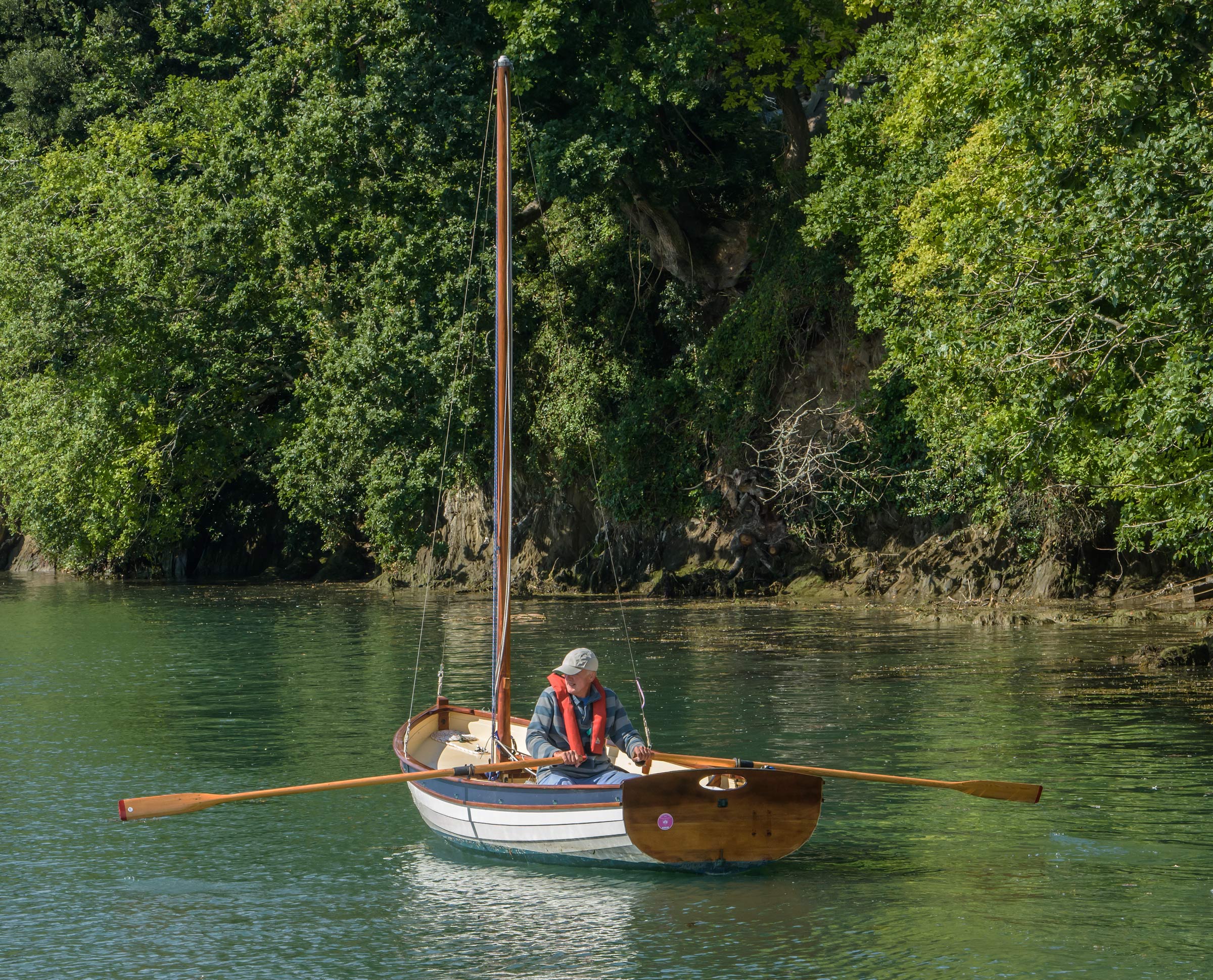
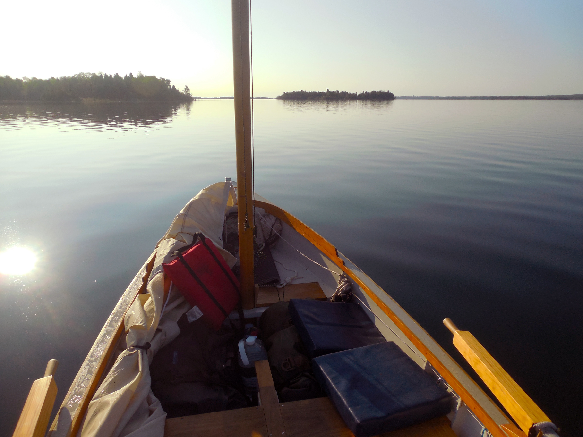
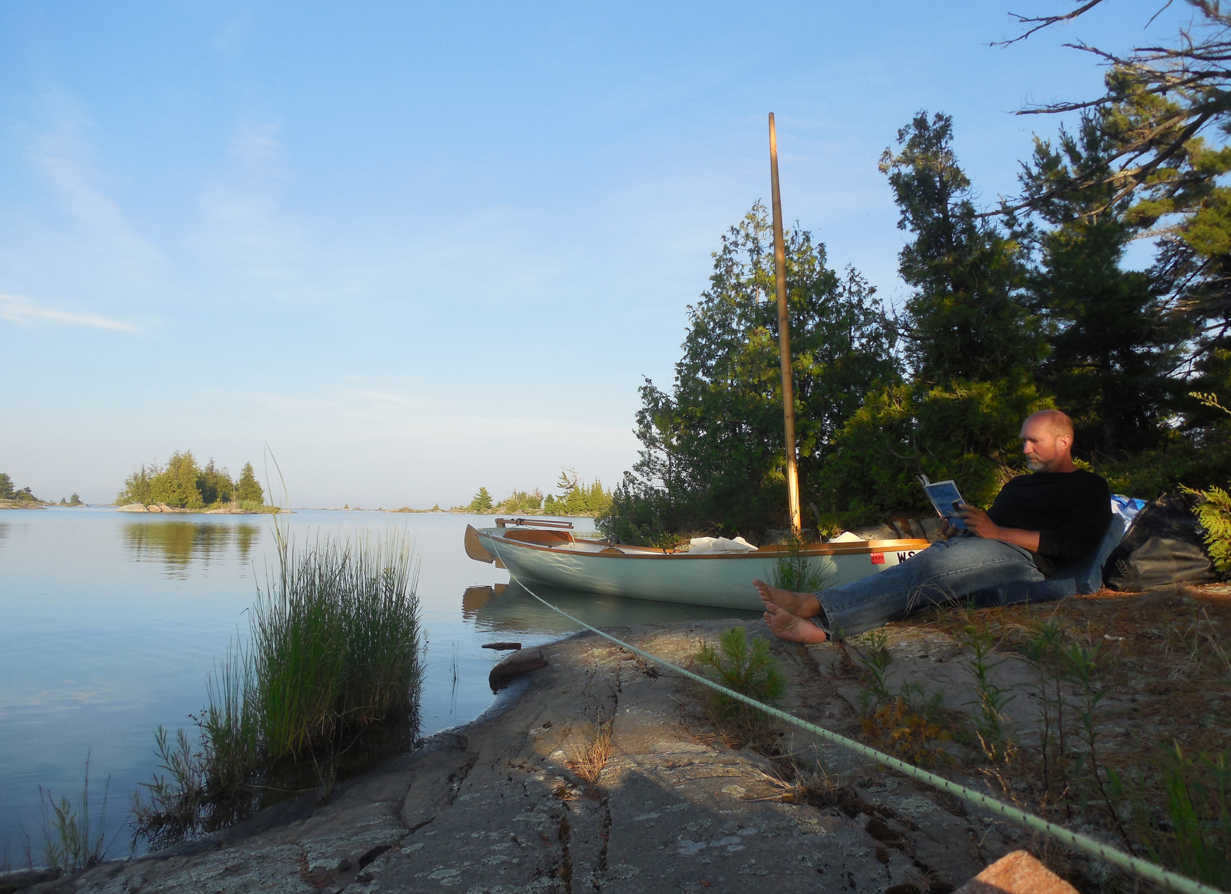
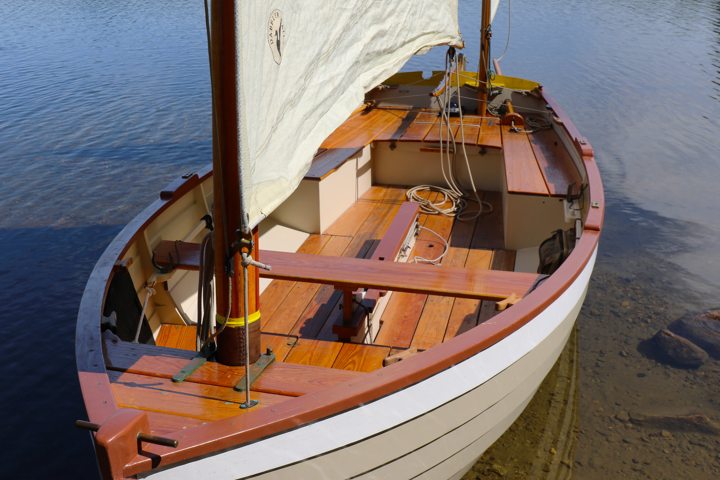
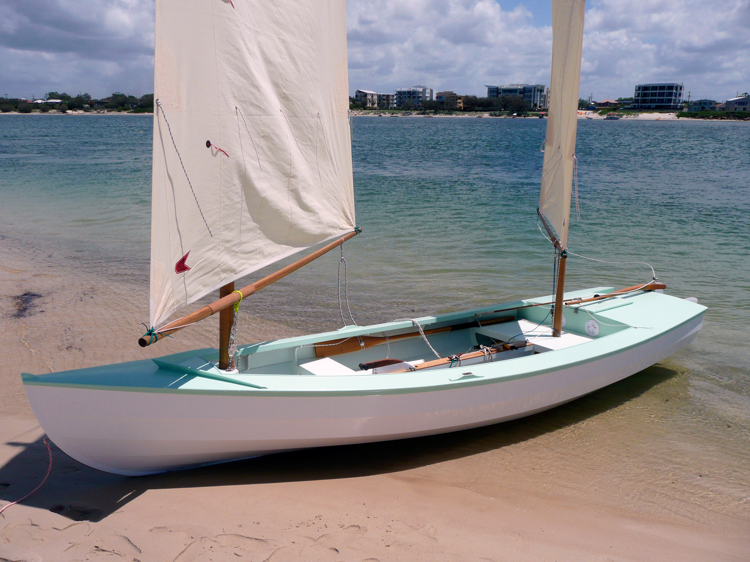
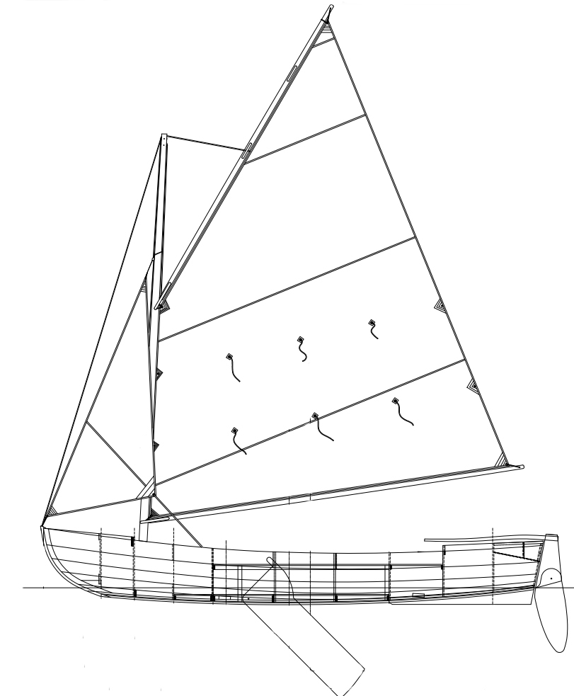
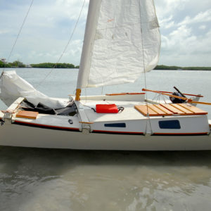
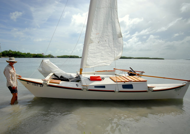
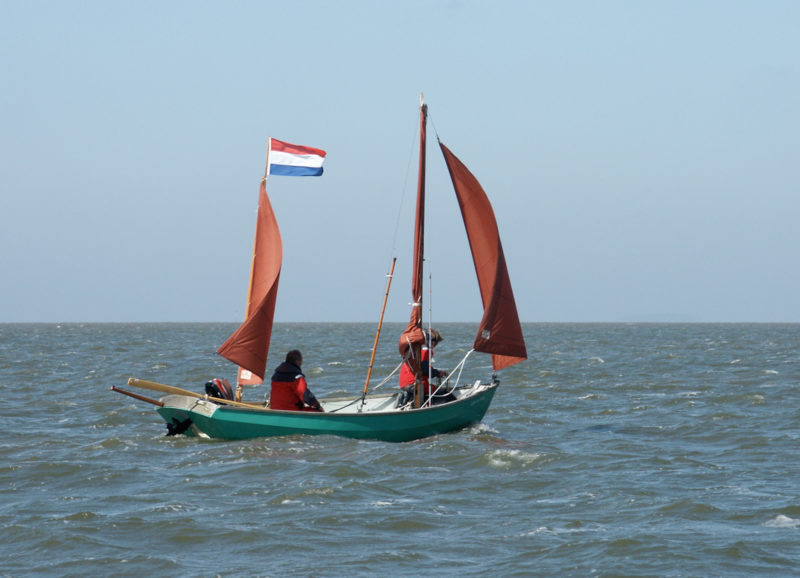
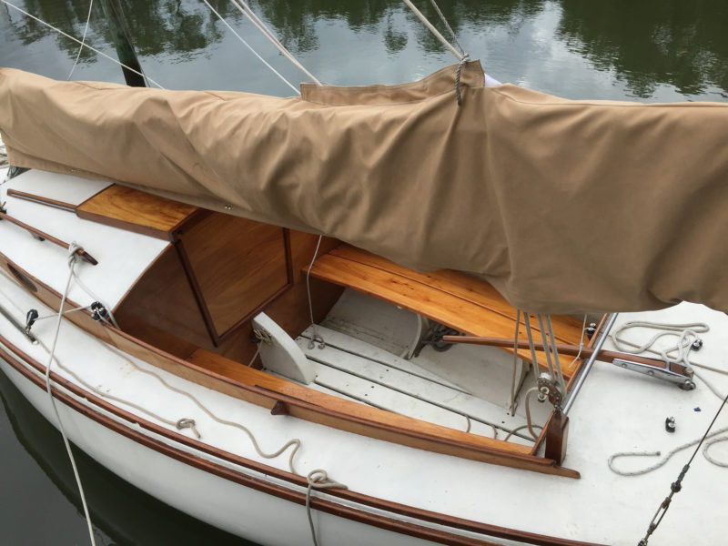
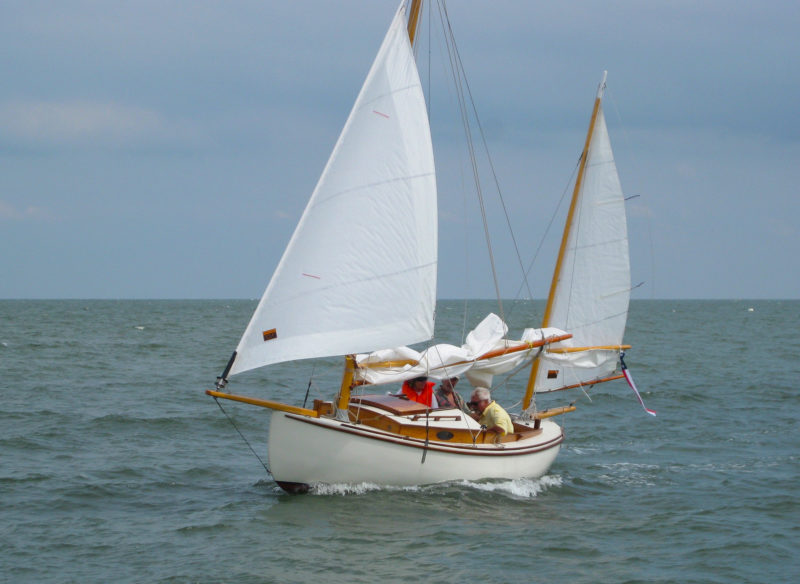
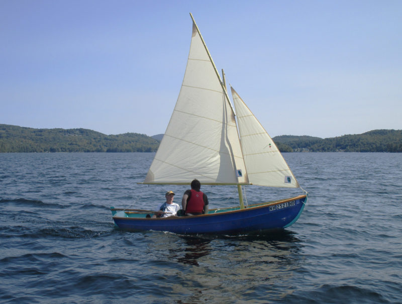
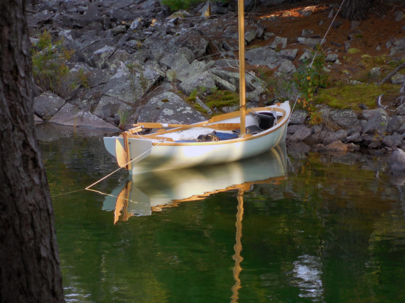
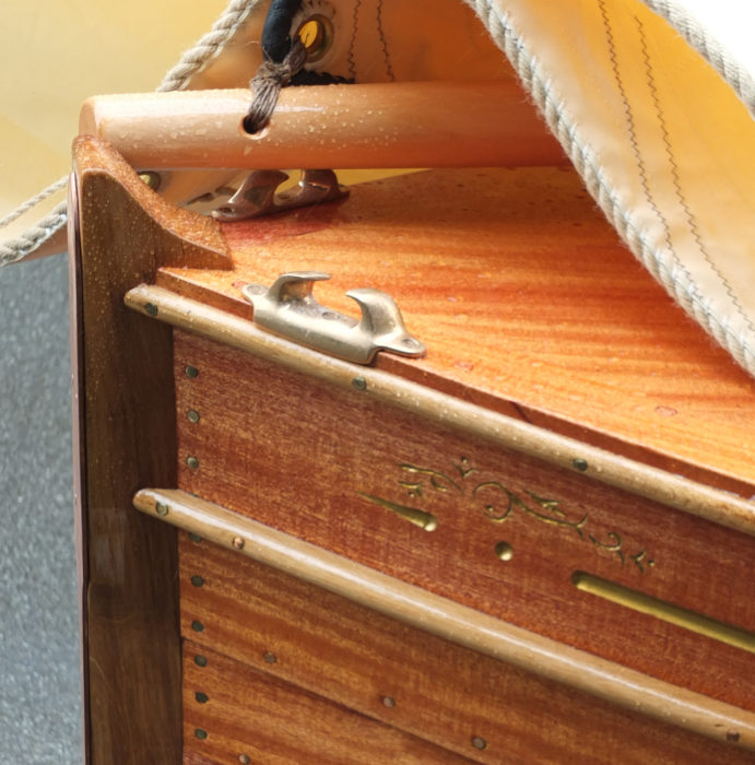
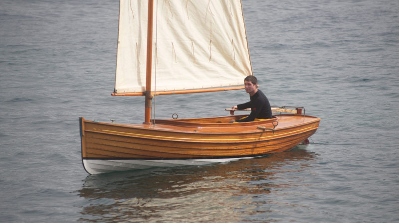
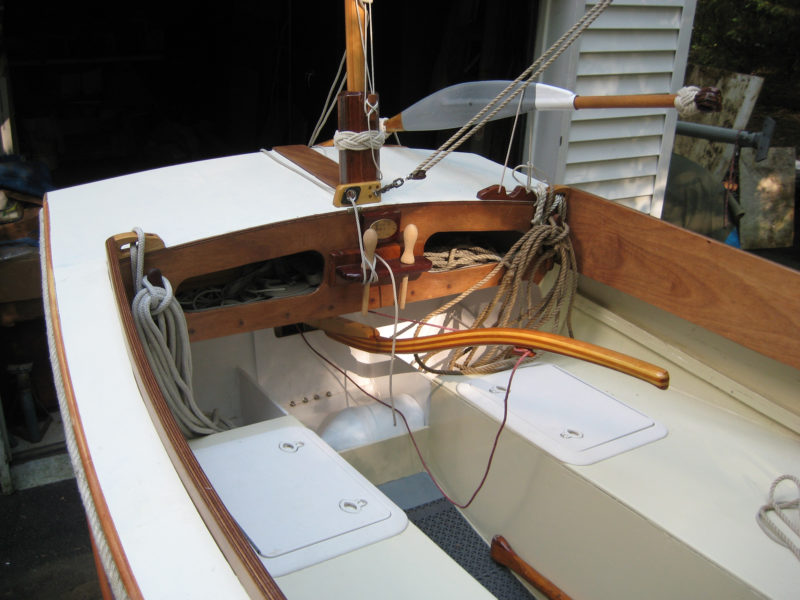
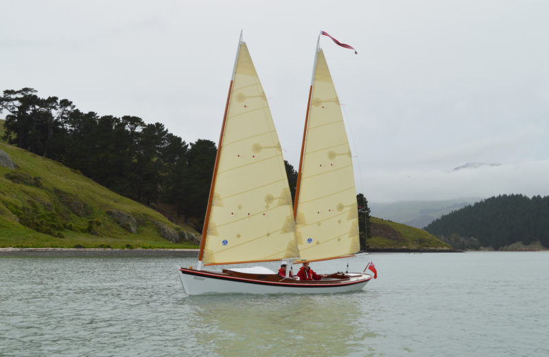
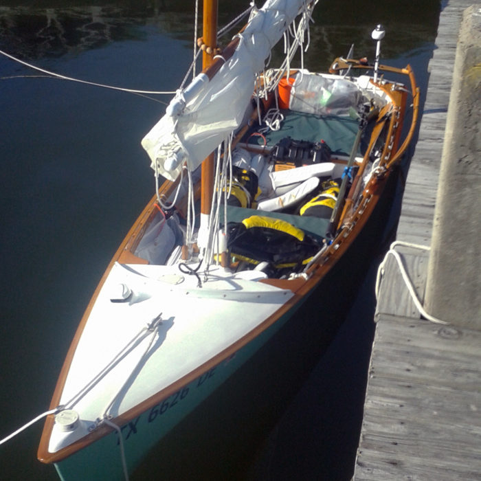
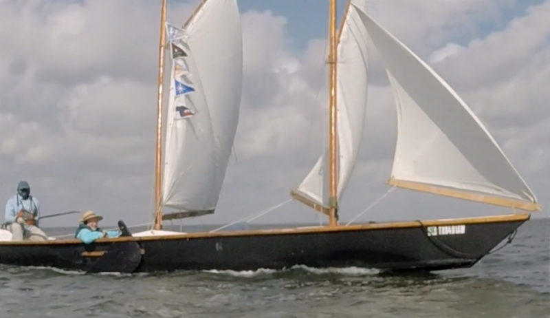
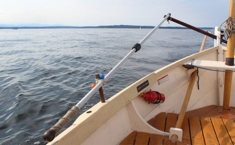
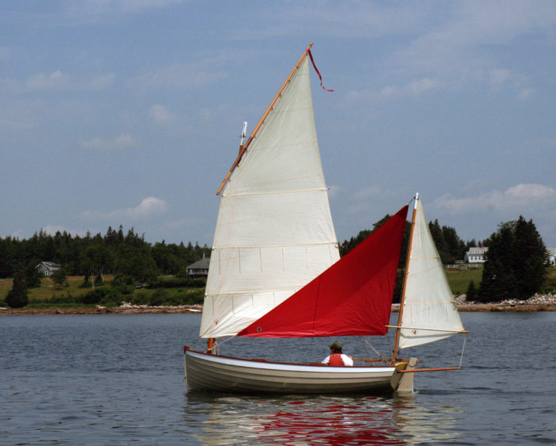
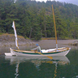
The mainsail, rolled around its yard, fits neatly to one side and below the level of the gunwales, leaving the center free for a rower and a passenger or two.
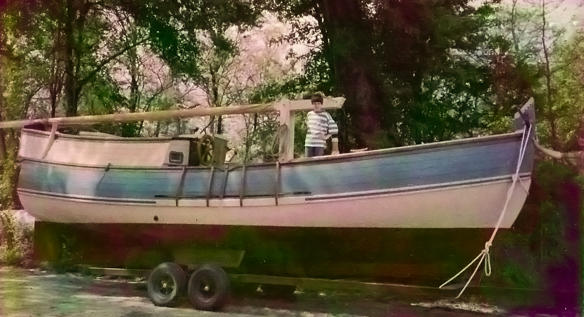
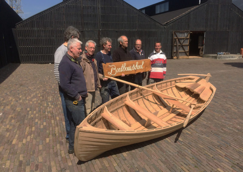
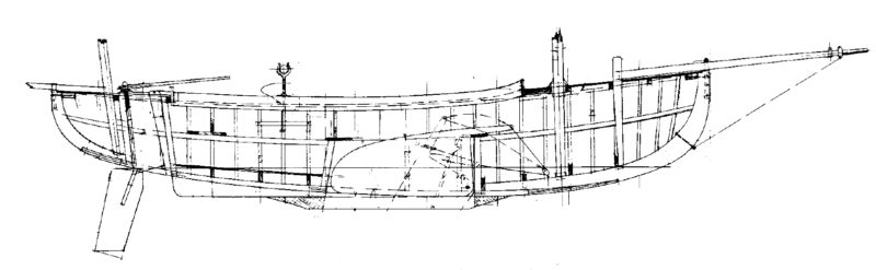
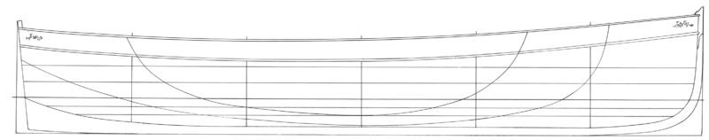
Scott is a member of the St. Ives Jumbo Association which keeps two 20’ Jumbos, replicas of Victorian fishing luggers, built by Jonny Nance, in the harbor. The starting point for that project was a 13′ rowing punt based on a set of lines Jonny’s father took from a traditional fisherman’s tender in 1975. Unlike the streamlined punts from more sheltered ports such as Falmouth on the south coast of Cornwall, the St. Ives punt was short and stout, heavily built to survive the challenging conditions of St Ives harbor. But could it be made to sail?
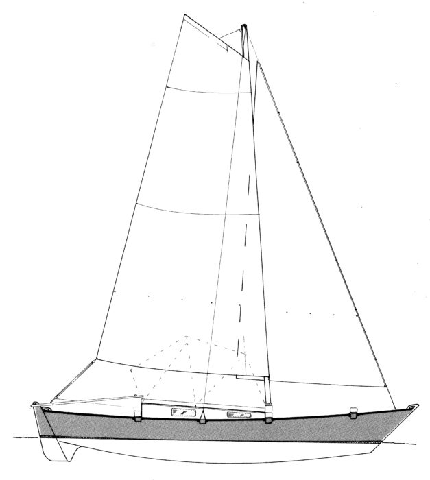
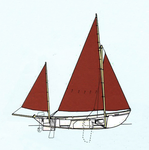
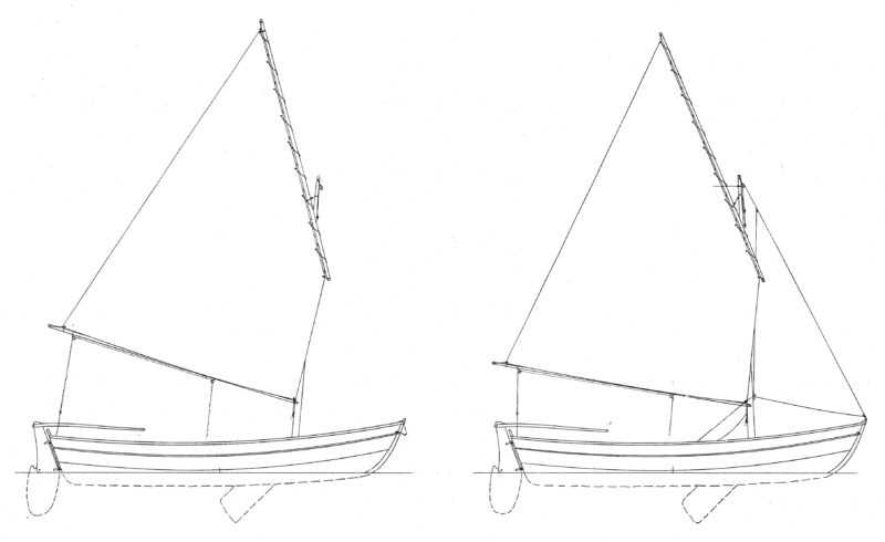
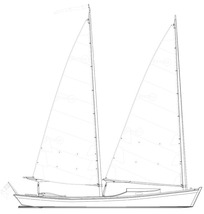
To find out, Scott teamed up with fellow Jumbo sailor Pete Lee and asked Jonny to design a sailing version of his father’s punt. The boat they specified had to be smaller and lighter than the rowing punt with a standing lug rig which would stand a trashing. It needed to be stable, so you could stand on the gunwale without tipping over, and withstand the abuse of various feral grandchildren. They didn’t want a centerboard, as the boat would be sitting on the beach at St. Ives—plus they wanted fewer moving parts for kids to get their fingers jammed. And the boat had to be pretty.
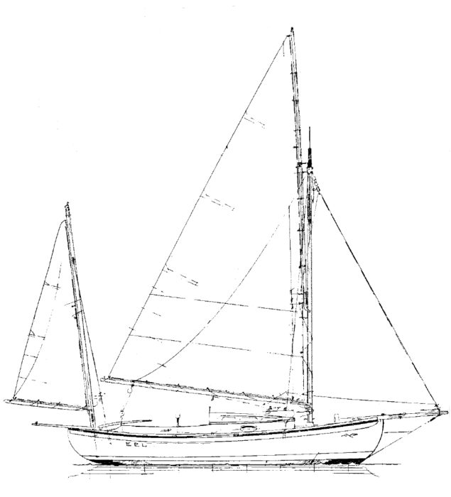
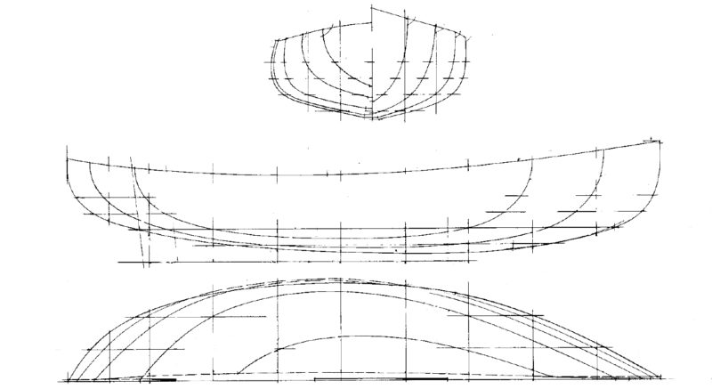
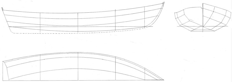
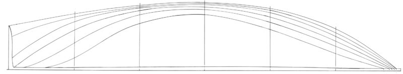
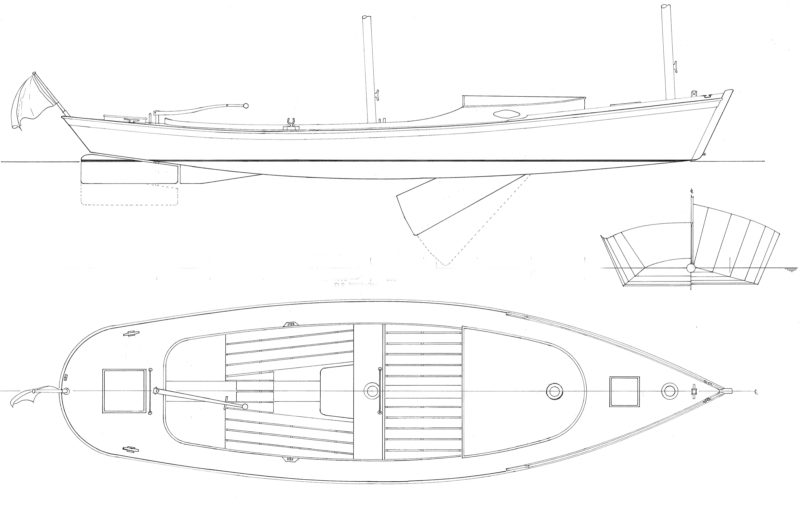
“It was an interesting challenge, given that the traditional punt was primarily for landing fish and had to be capable of carrying the maximum weight in the minimum amount of water!” says Jonny. “I modified the rowing punt lines to make the boat as sailable as possible. I raised the deadrise a little, so it’s not so flat bottomed; the sailing punt’s keel projects about 3″ below the garboard, whereas the rowing punt only has 2″. The sailing punt also has a much more elegant run aft and finer entry. Little things, to make a sailboat shape without diverting too much from the punt type that she is.”
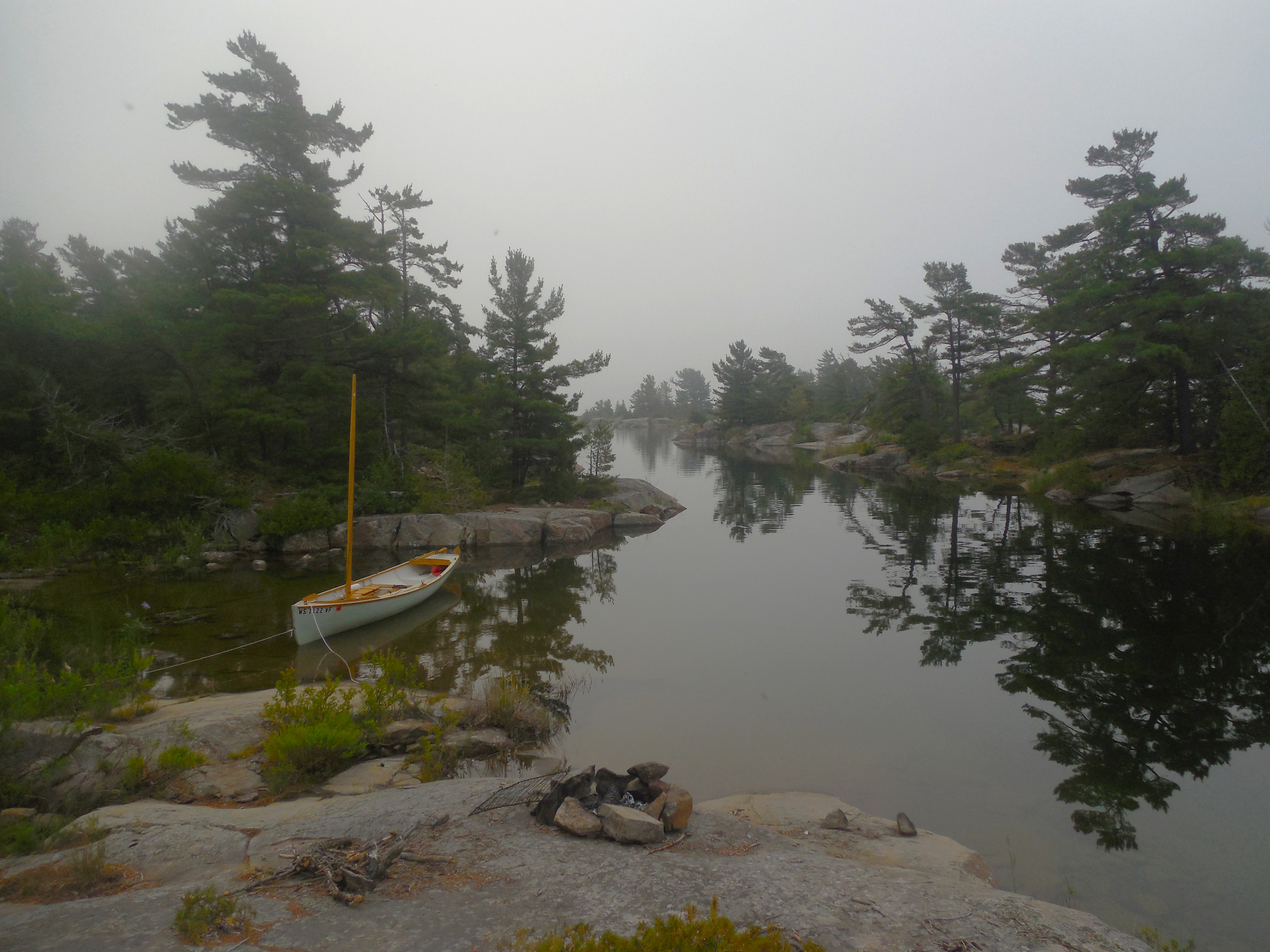
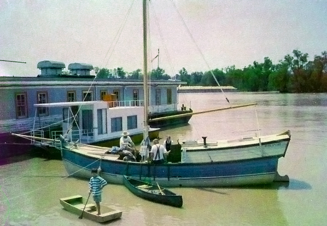
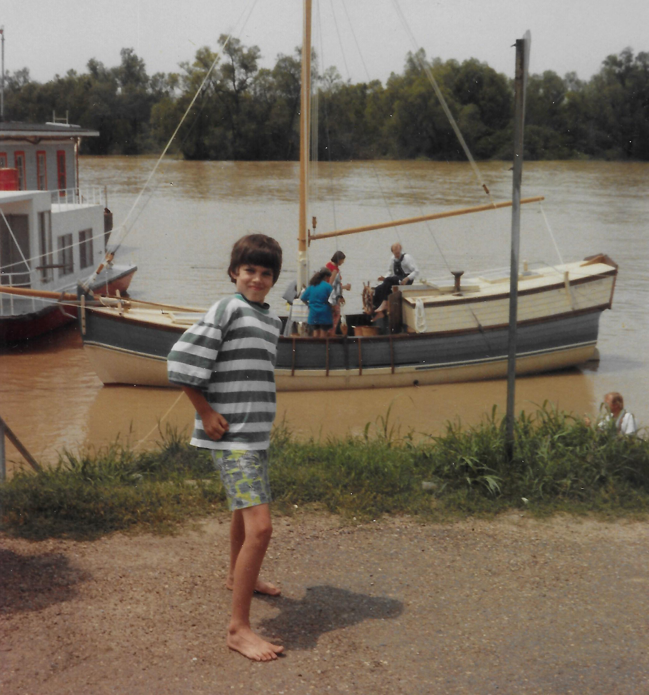
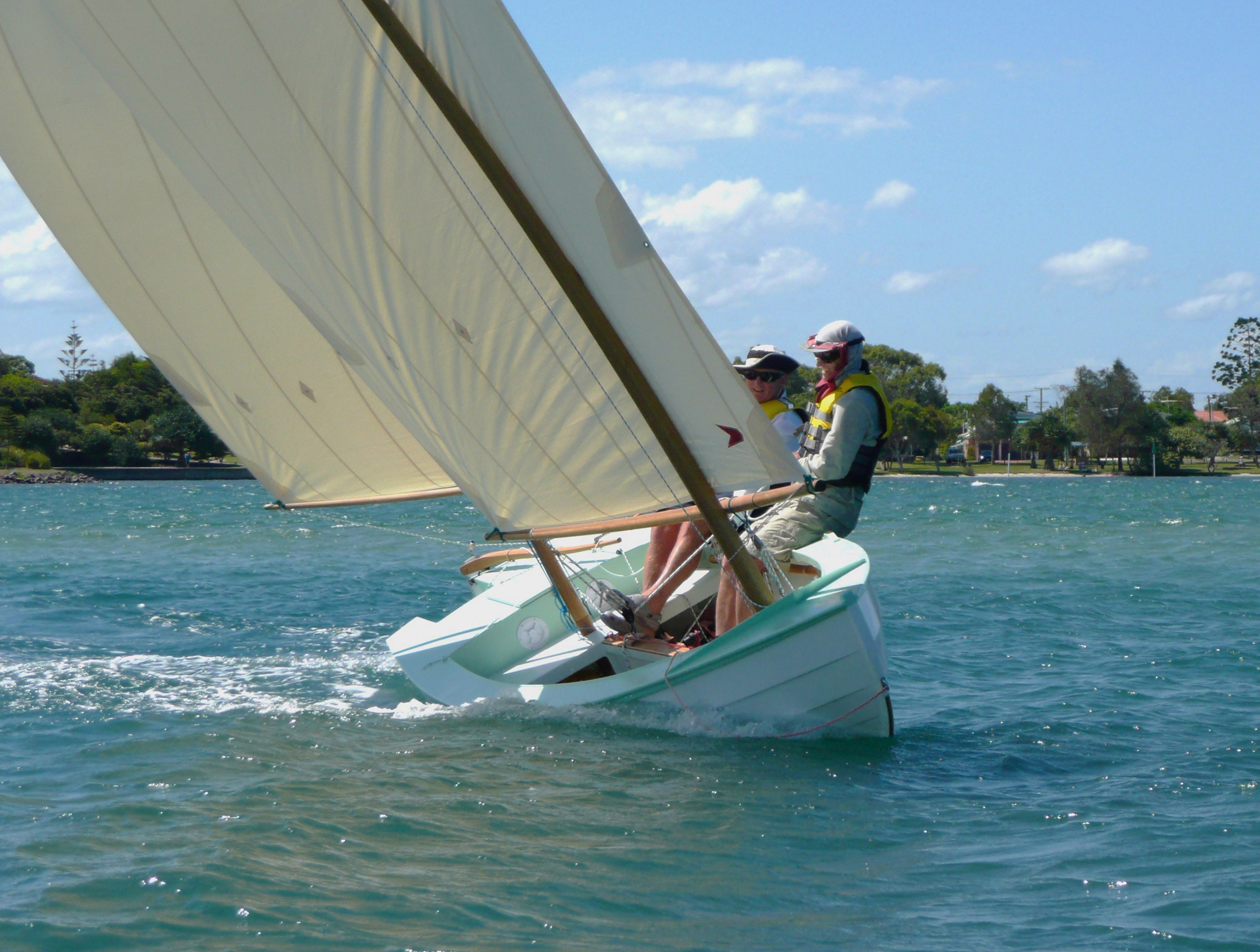
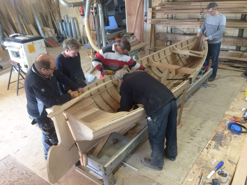
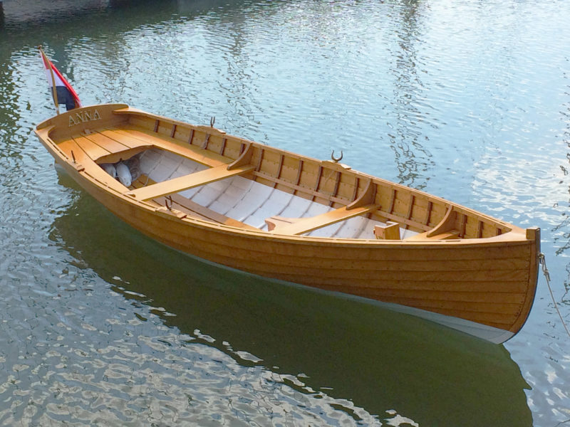
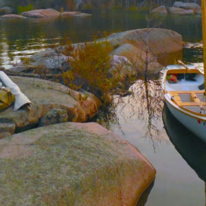
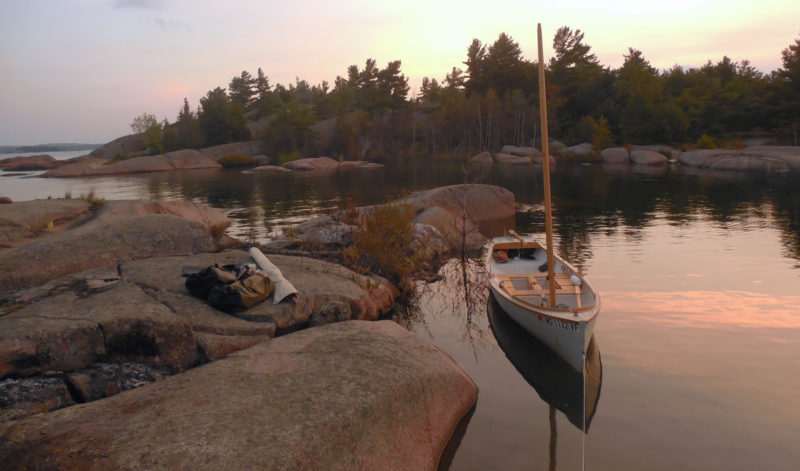
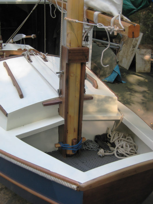
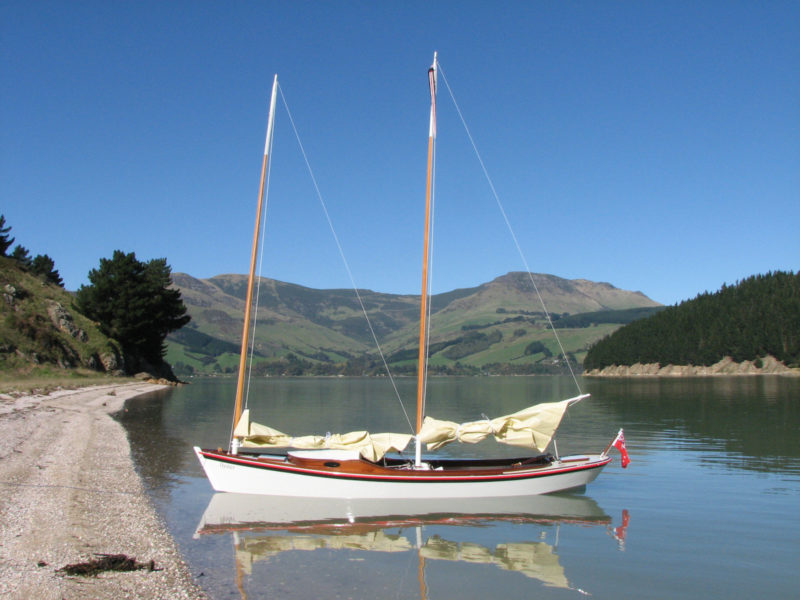
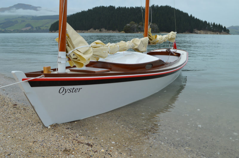
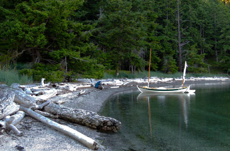
Jonny built the first St. Ives sailing punt for Pete in 2014, followed by a second boat (with a slightly taller mast) for Scott in 2015. Good-quality larch wasn’t available for the planking, so Jonny built both boats of Douglas-fir on oak ribs, fastened with copper rivets. The inside was fitted with oak thwarts and grown oak knees, all sealed with a mix of Stockholm tar, linseed oil, and turpentine, which quickly turns black with age. Scott named his punt MAIA, in part after Saint Ia of Cornwall who, according to legend, sailed to St. Ives from Ireland on a leaf, and in part after one of the Pleiades, Maia, from Greek mythology.
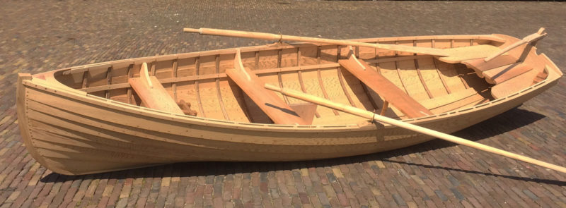
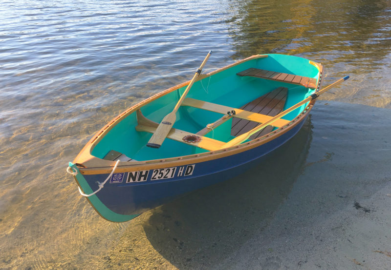
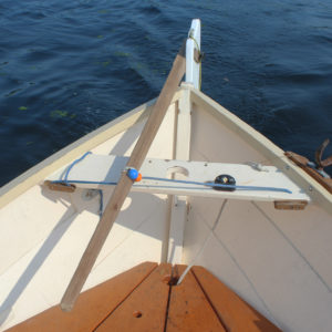
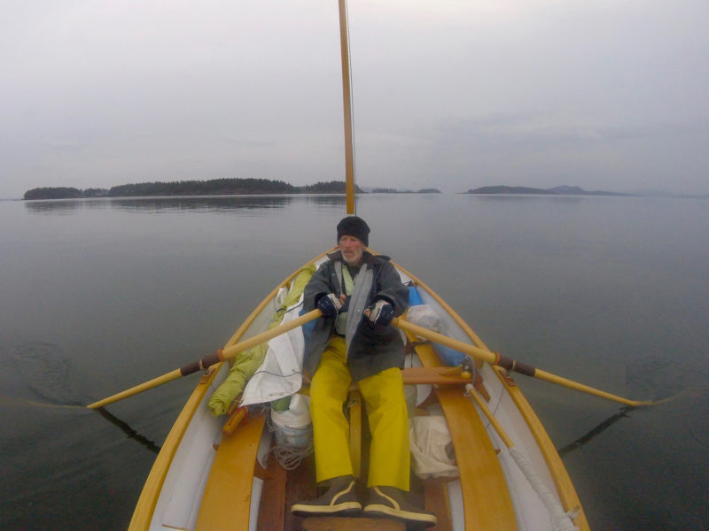
The St. Ives here has two rowing stations rigged with removable tholepins. The oars, as is customary for double tholes, are without collars, requiring a bit more skill from the rower than oars with collars used in oarlocks.
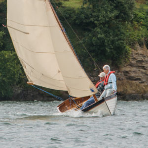
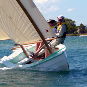
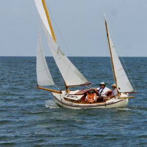
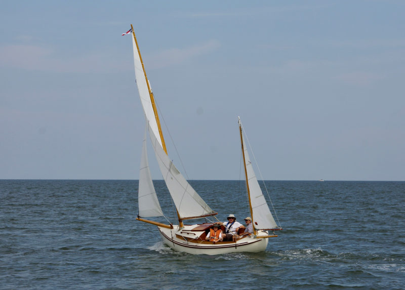
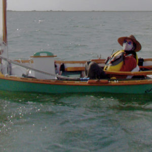
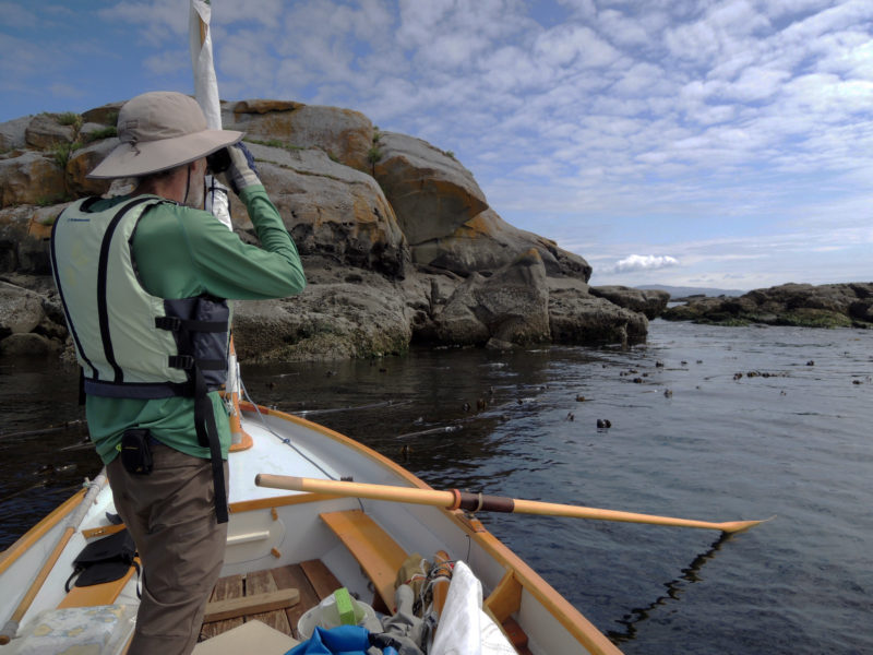
It was glassy calm and cloudy when I arrived in St. Ives to sail MAIA, so we made the most of the weather by first testing the boat in rowing mode. The St. Ives punt has two rowing stations, both fitted with tholepins rather than rowlocks. I’m not a usually great fan of this arrangement, which I suspect is usually used for aesthetic rather than practical reasons, but I have to admit I hardly noticed the difference on this occasion.
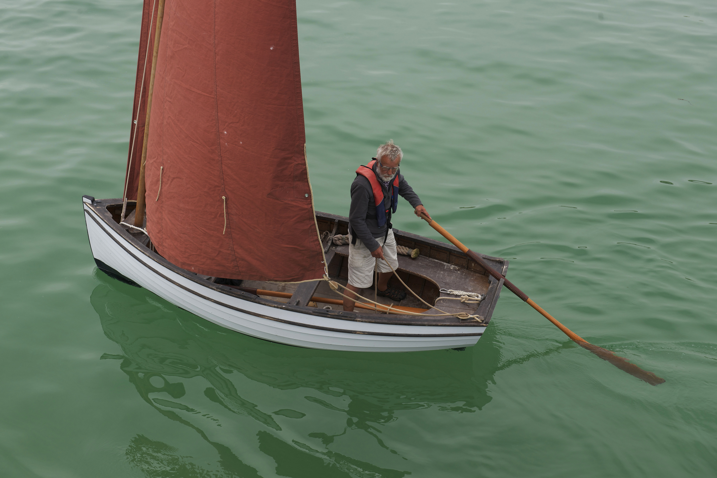
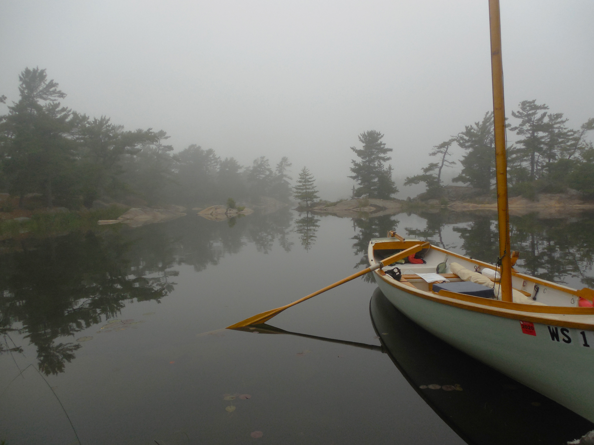
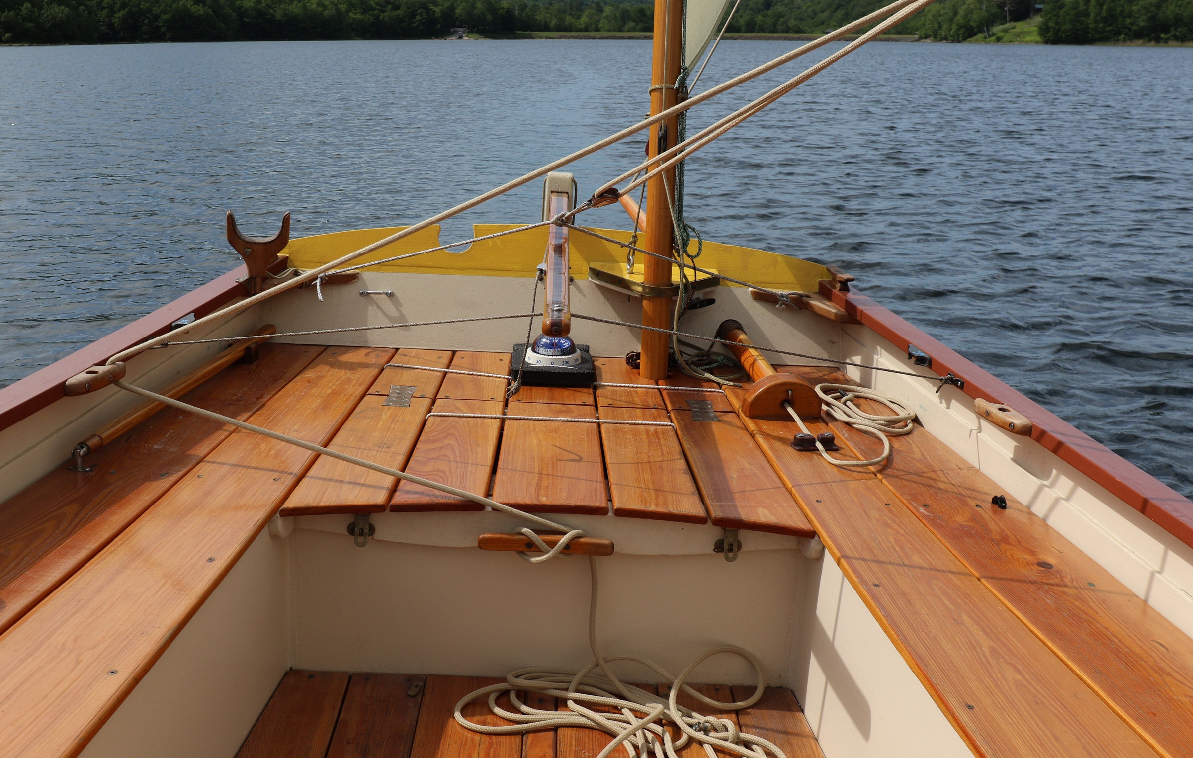
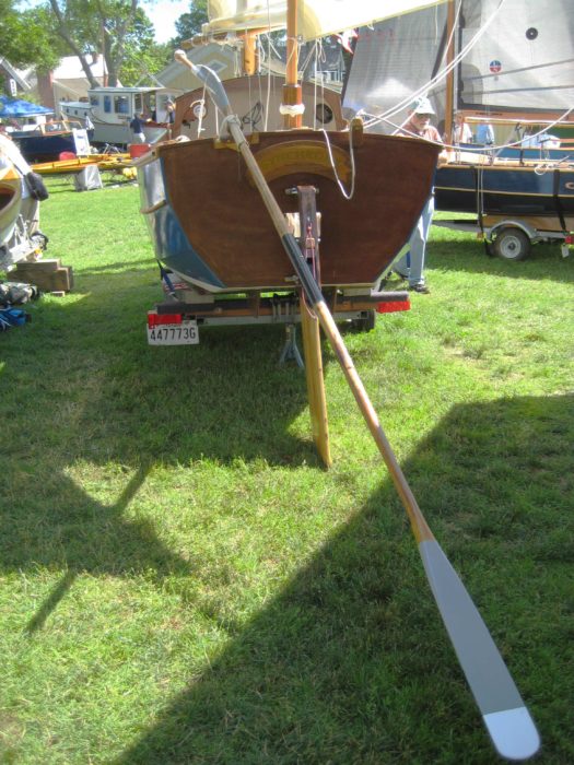
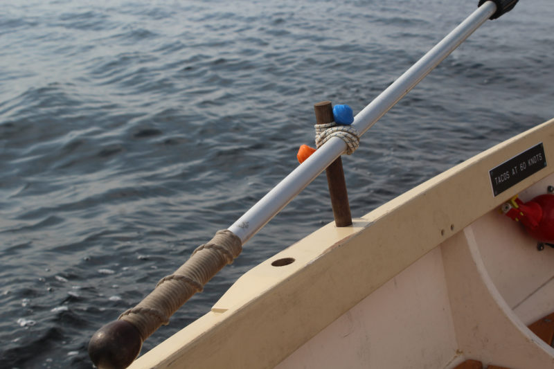
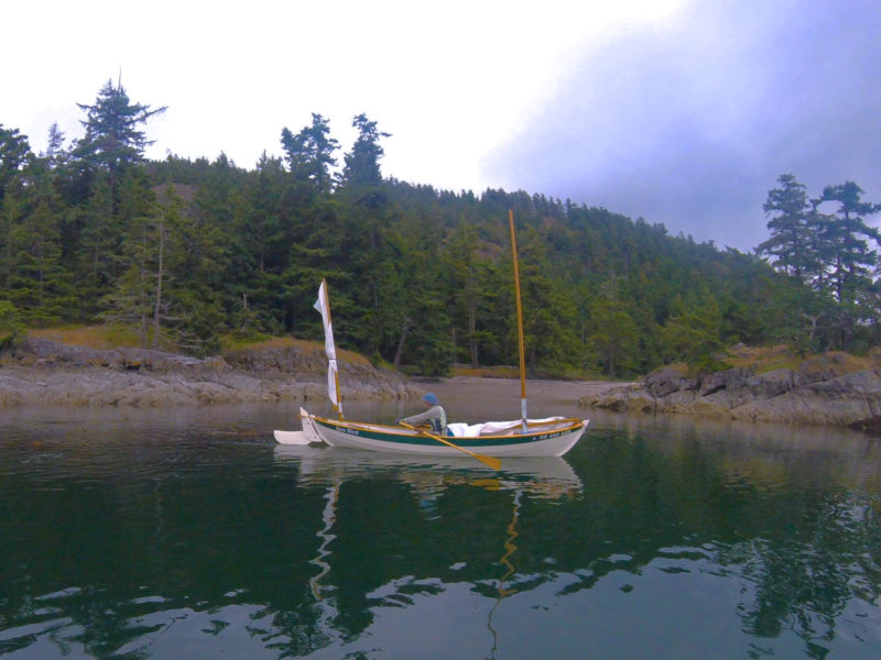
With her beamy, burdensome hull, the punt is not best suited to long-distance rowing, though it carries its way well enough and you would happily row home if you had to. In practice, though, I suspect the oars are mostly used to get her in and out of harbor. The Jumbo crews are keen scullers, and the transom has been fitted with a sculling notch, set off-center so it can be used with the rudder and tiller in place.
The rudder isn’t in place at the moment, but if it were, it wouldn’t interfere with sculling because the notch in the transom is set to port. The notch is circular with an opening at the top wide enough to accept the throat of the oar, but too narrow to let the leathers slip through. The arrangement keeps the oar from slipping free, handy when sculling or when using the oar as a stand-in for the rudder, as seen here.
“Sculling was the principal means of propelling a punt in crowded fishing harbors, as it was seldom possible to row,” says Jonny. “So sculling isn’t just a quirky revivalist fad. It remains a very useful skill and is frequently the most appropriate option.”
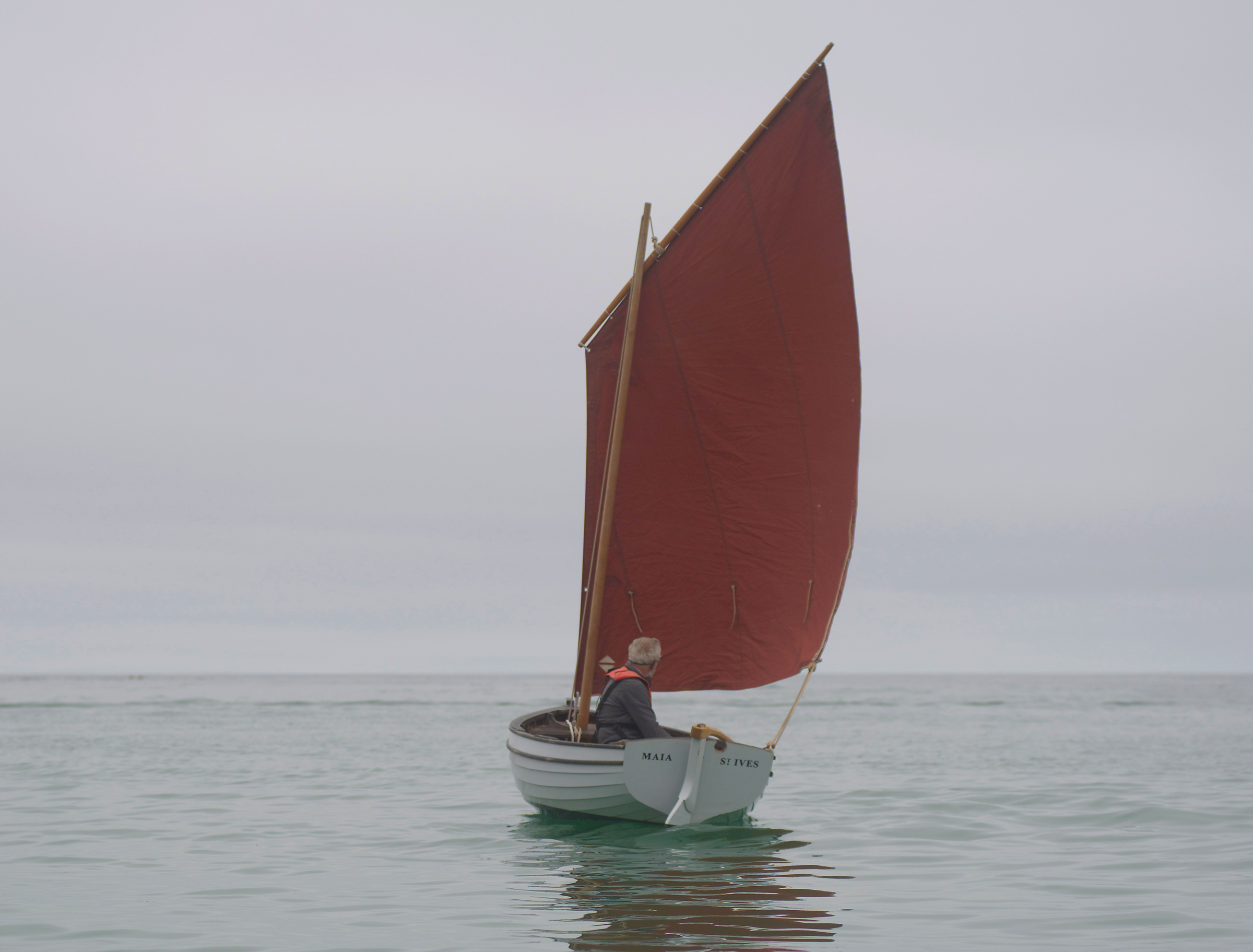
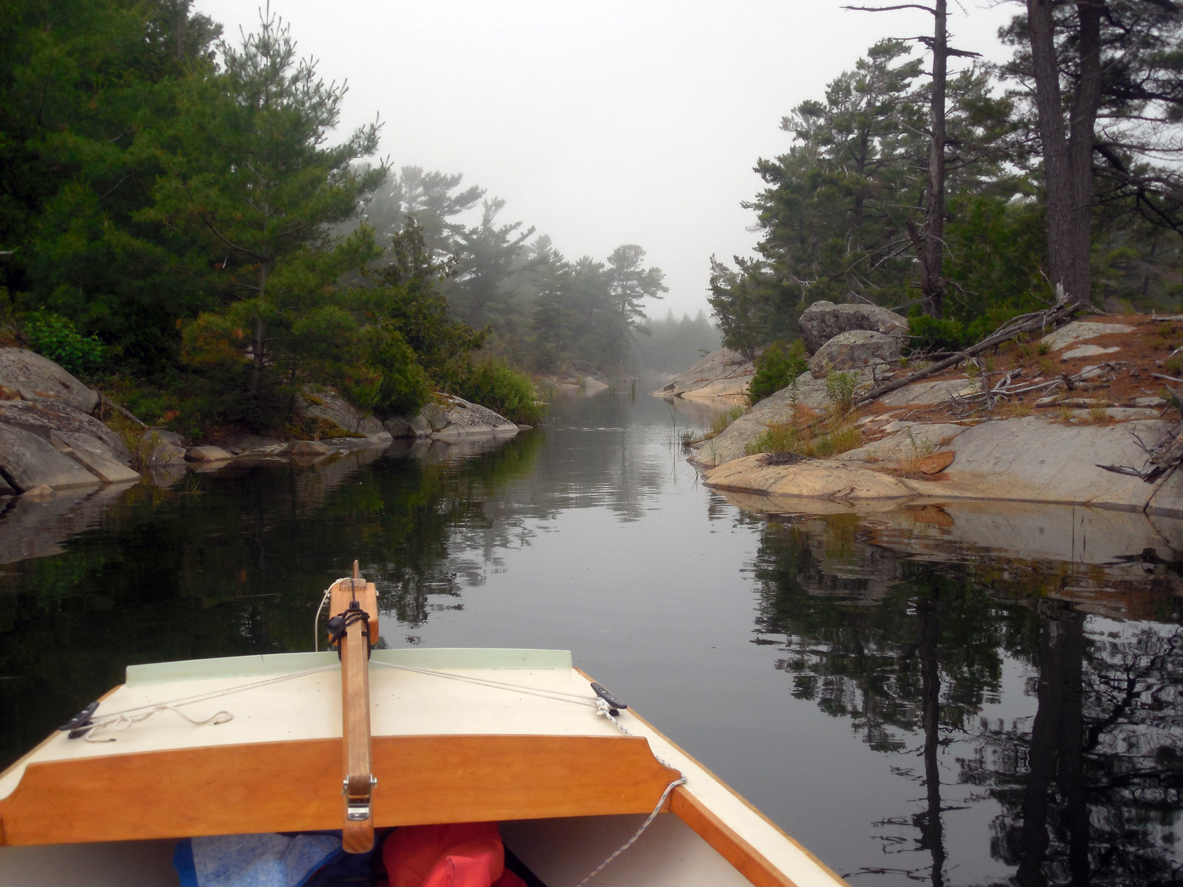
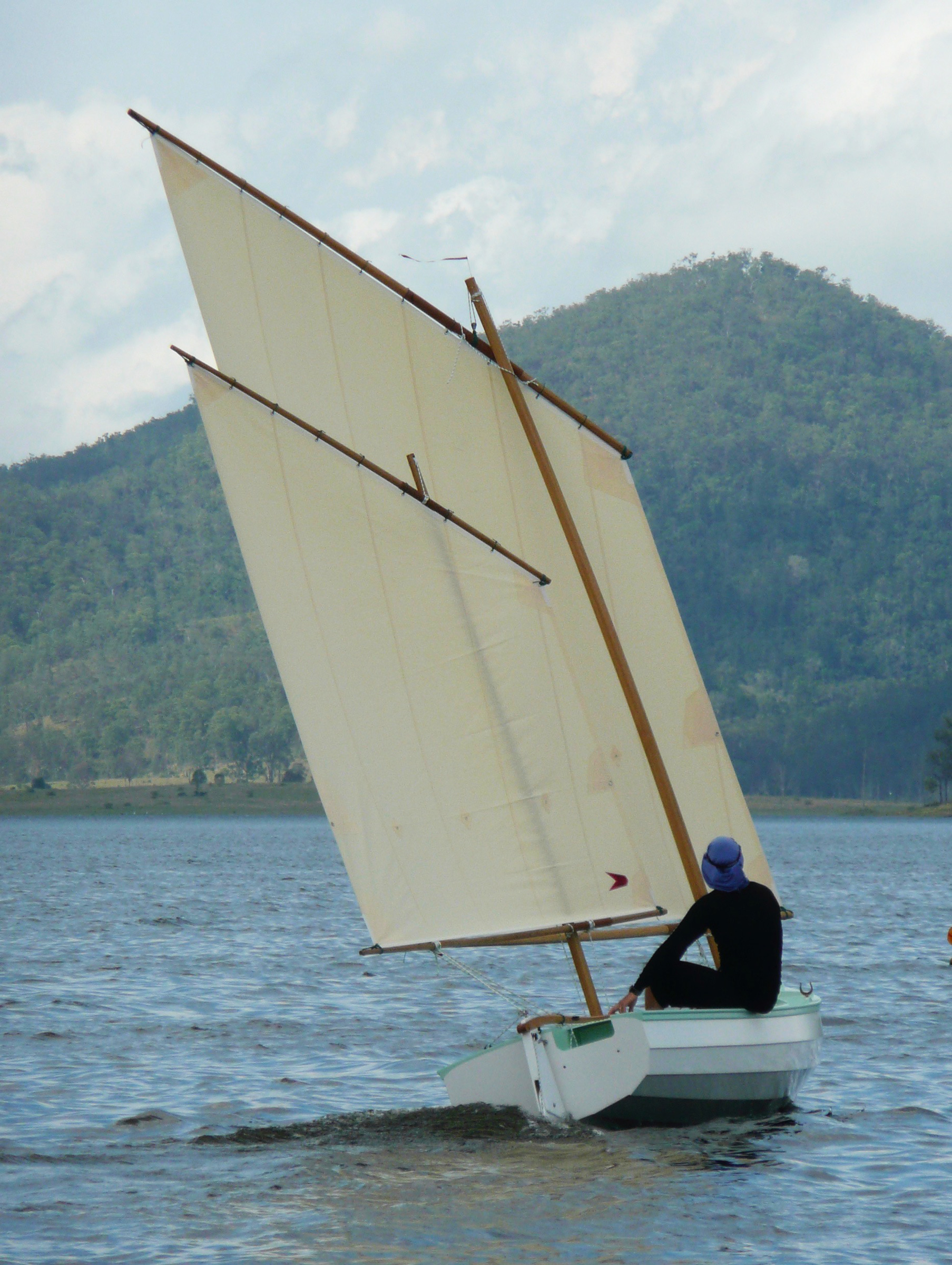
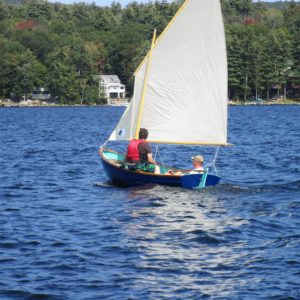
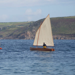
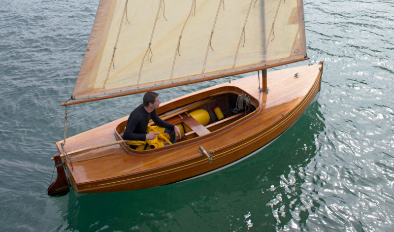
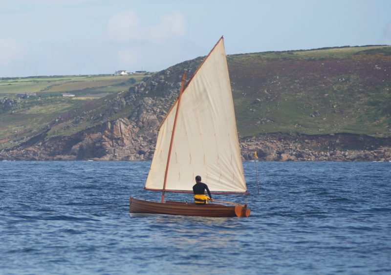
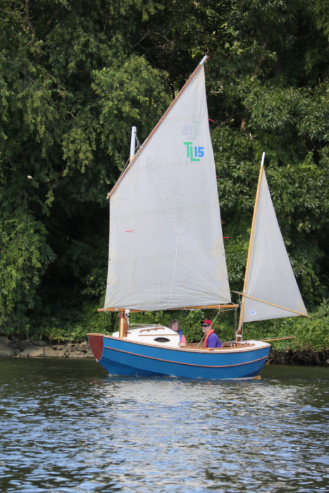
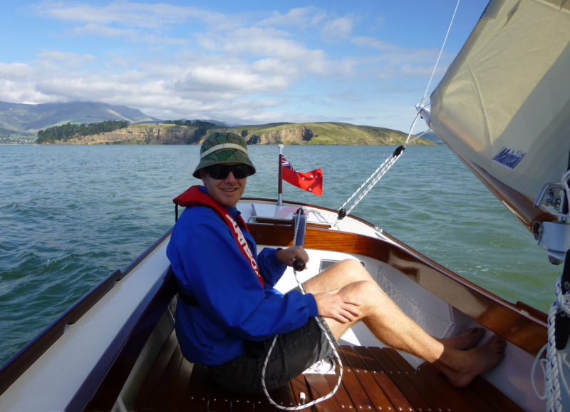
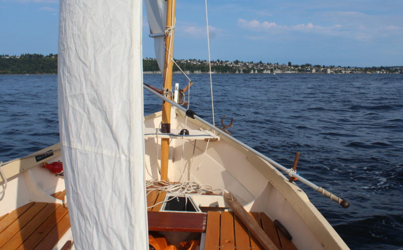
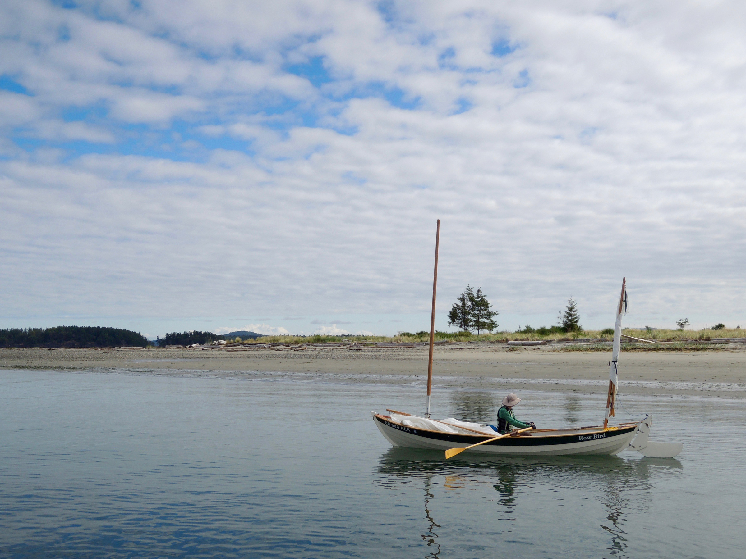
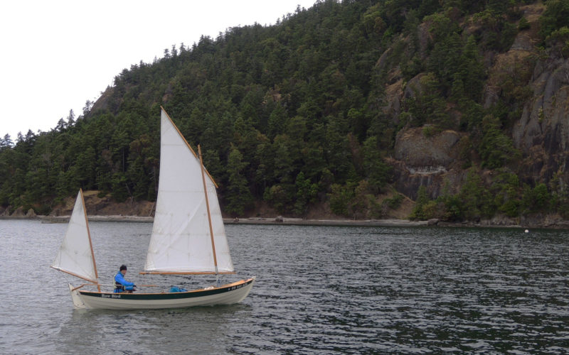
While we were trying out the oars, Scott’s other boat, ZEPHYR, turned up, and I jumped aboard to take some photos of Scott rowing and sailing his punt. The simple standing-lug rig, with its stayless mast, is extremely easy to raise and lower—one reason it was so popular with fishermen—and within a couple of minutes the boat was under way.
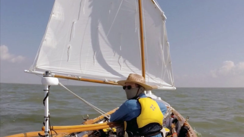
I feared the St. Ives punt might be a bit sluggish under sail, but it soon proved me wrong. Even before the surface of the water had been ruffled by the breeze, it managed to catch a breath of wind and, as if by magic, sailed away purposefully over a glassy sea, before the natural order was restored and a few ripples appeared below the bow. Even then, as a feeble wind blew hesitantly across the bay, it seemed to keep its way and made steady headway almost regardless of the wind.
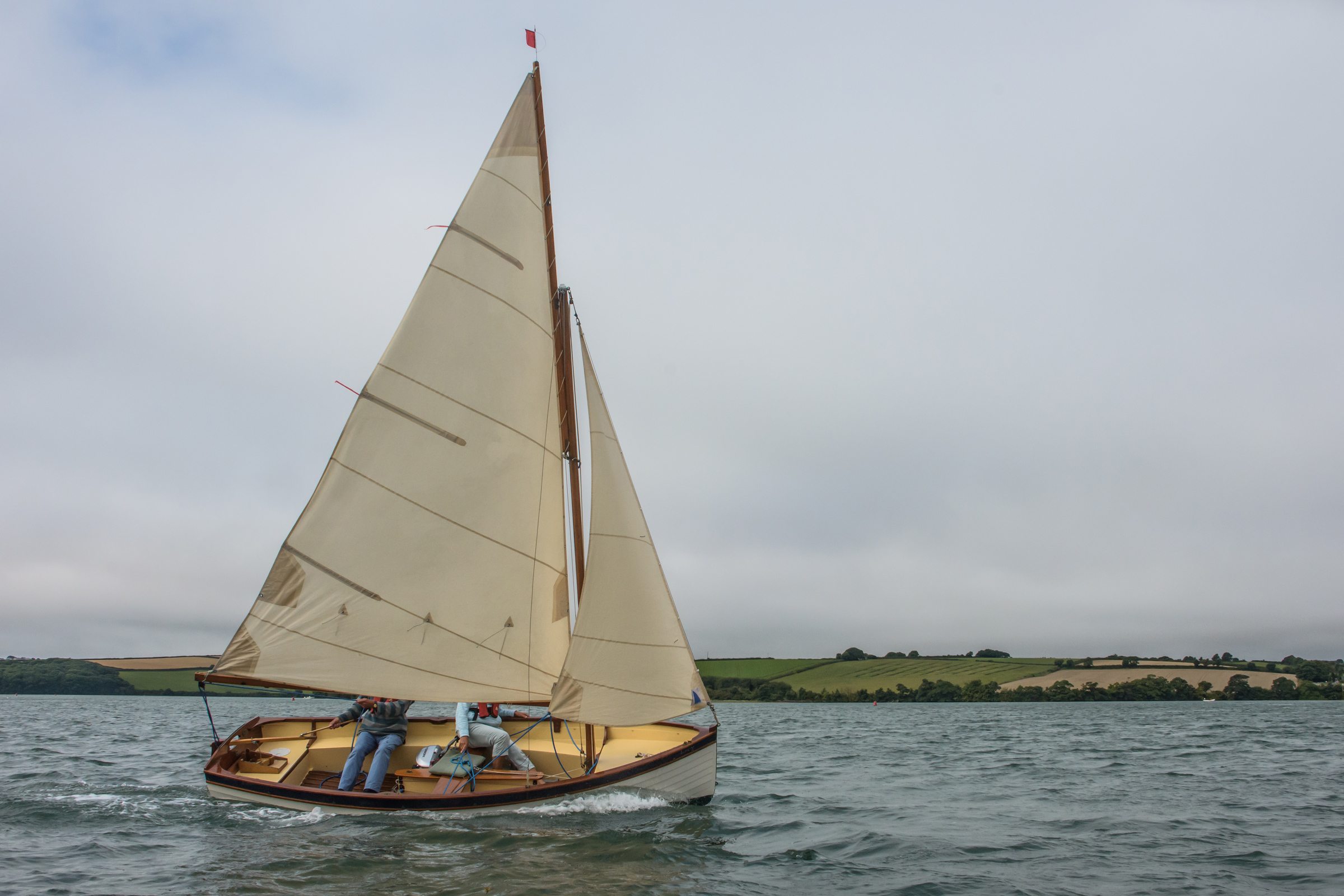
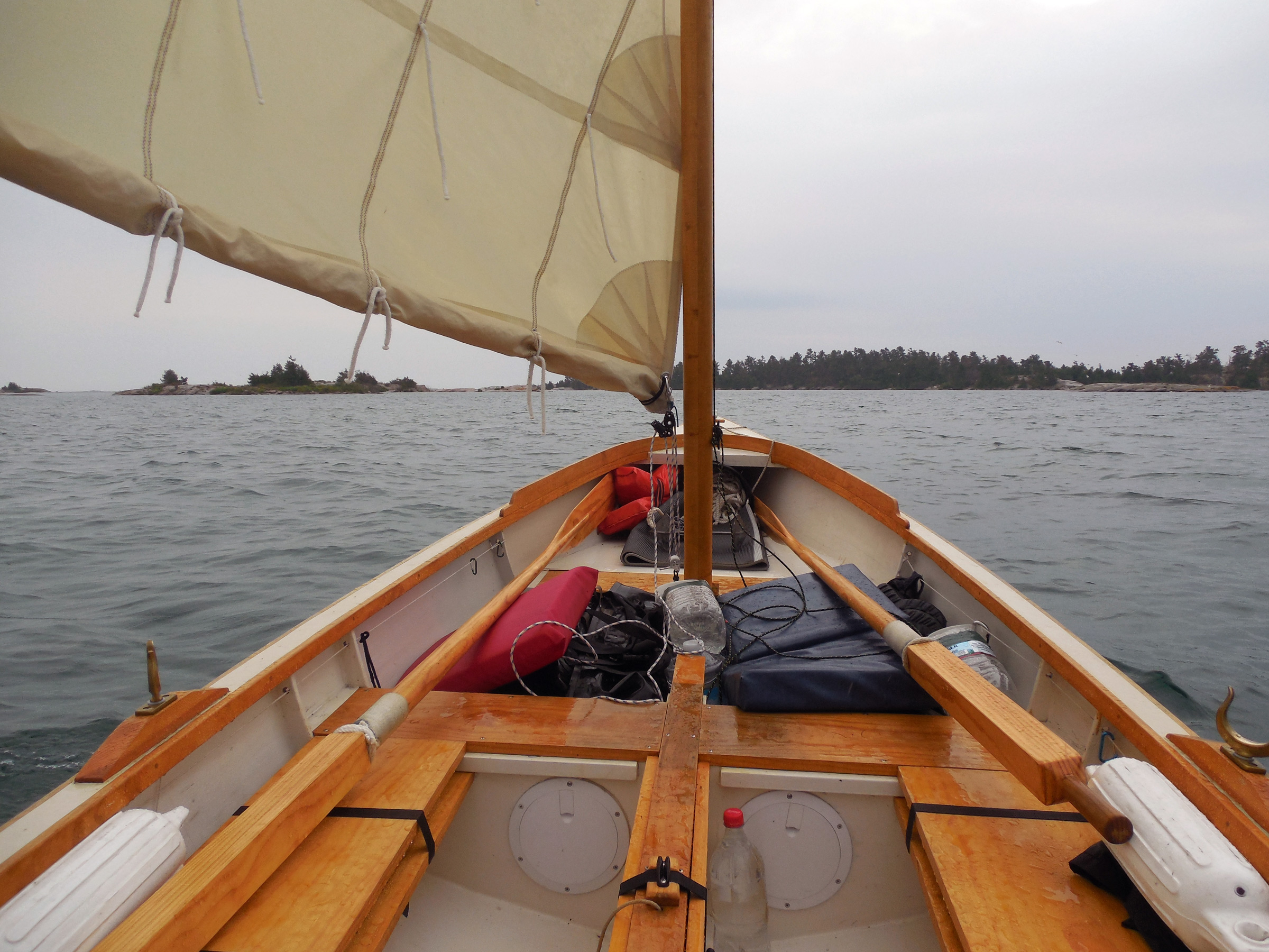
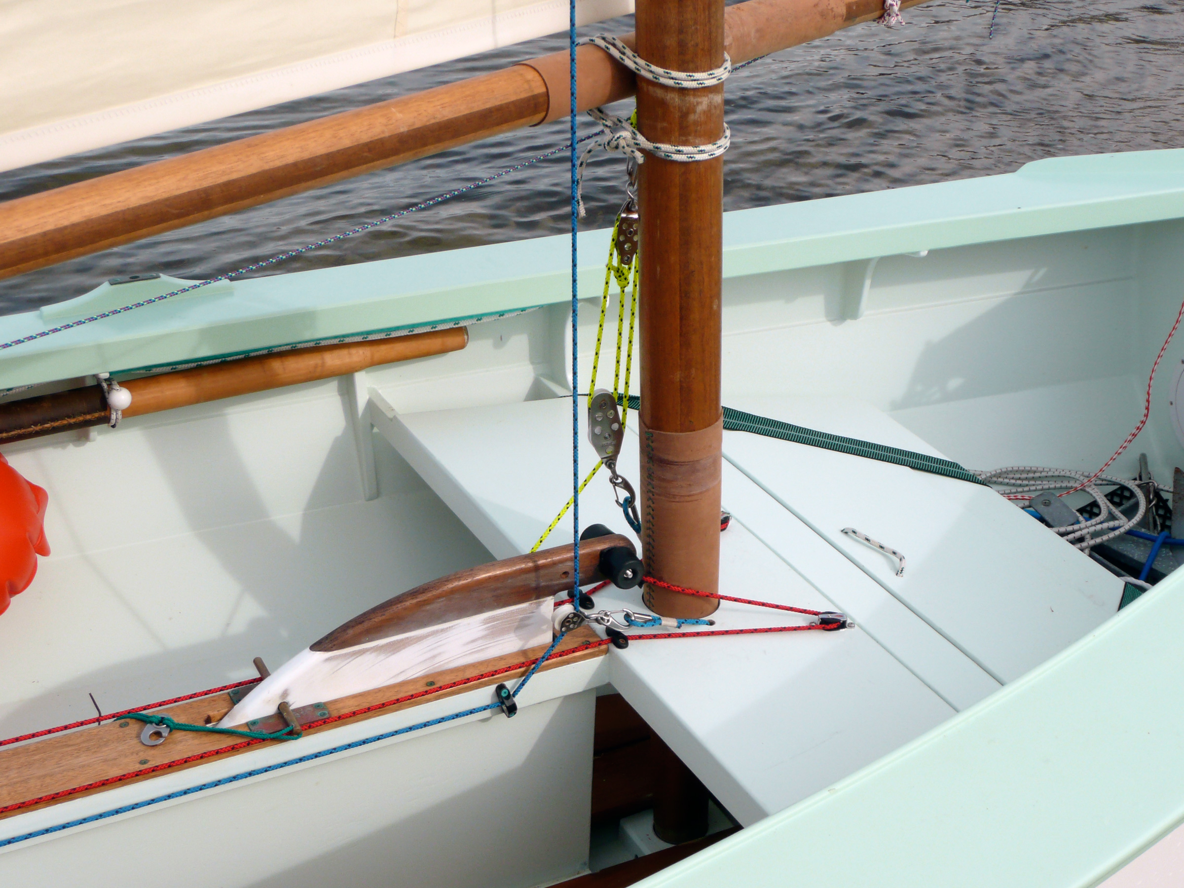
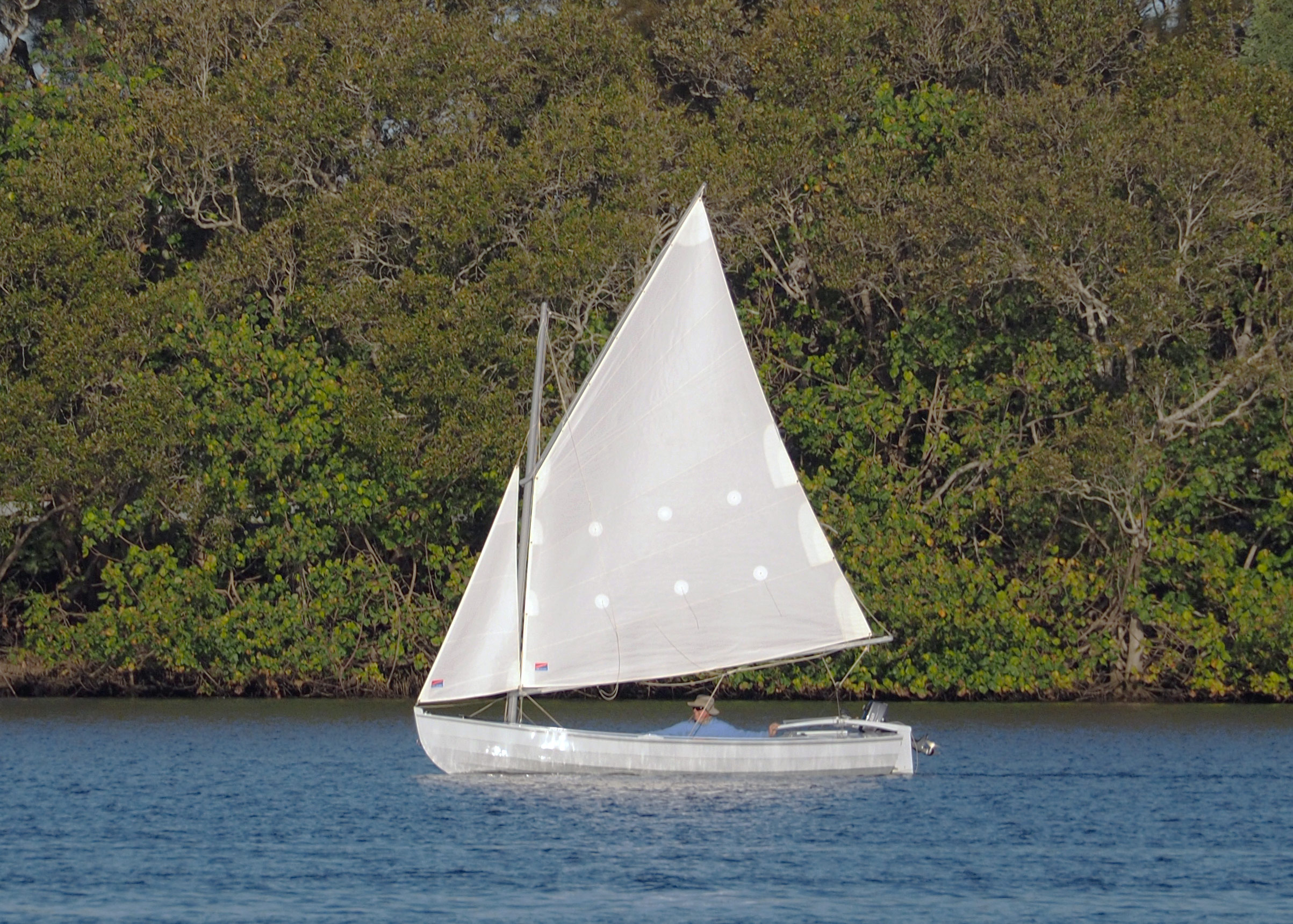
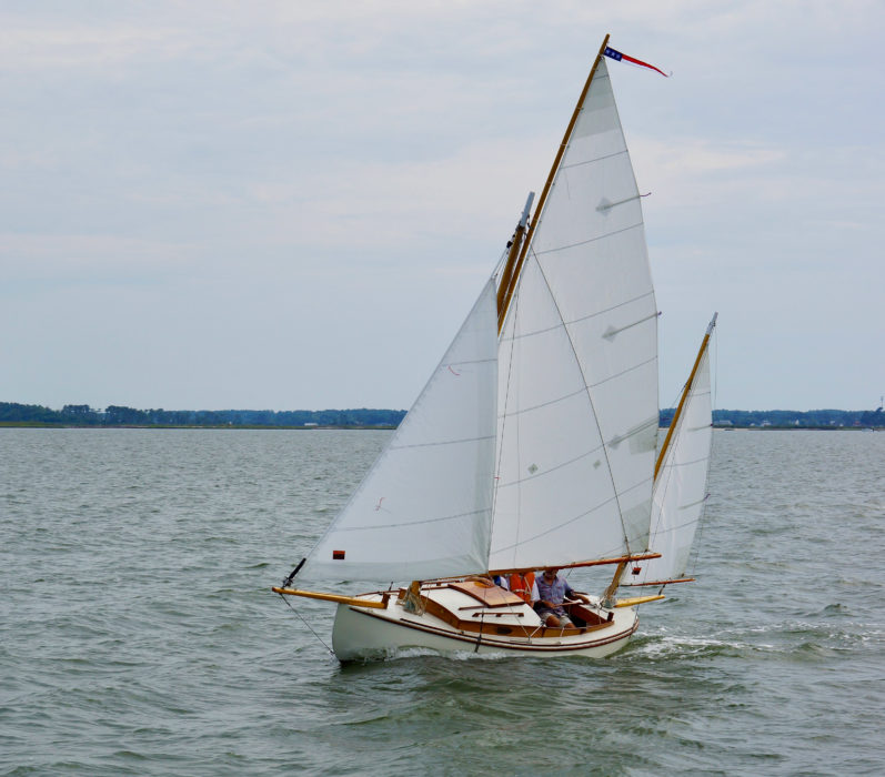
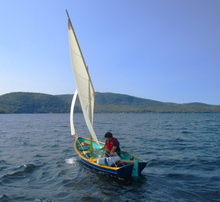
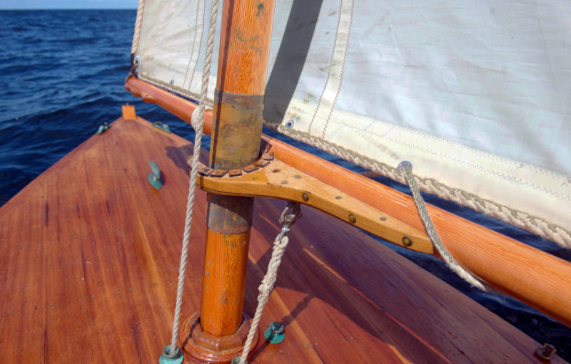
The loose-footed lugsail makes setting sail as simple as it can be. The mainsheet runs through a rope-stropped block with an eye that slips over thumb cleats, one on either quarter, close to the transom. A second block at the clew gives the skipper a 2:1 advantage.
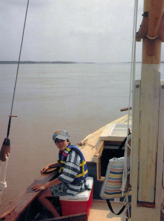
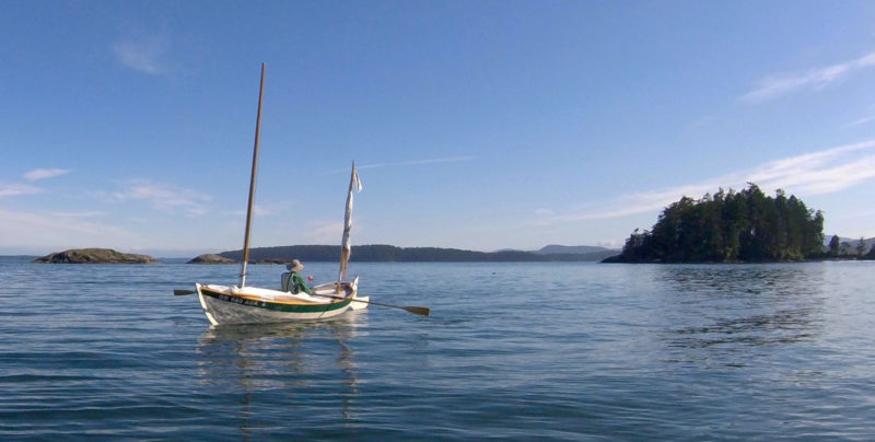
The punt kept up its uncanny ways after I climbed on board to join Pete, and we headed out past Bamaluz Point toward the open sea. A strong current was setting us to the west, with just a puff of wind from the southwest, yet as we turned around and headed back to St. Ives, the punt slipped along as if pulled forward by an invisible line. Of course, by then we were on a broad reach, and I suspect it would have been a very different matter if we’d had to tack to windward, not the St. Ives punt’s strong point.
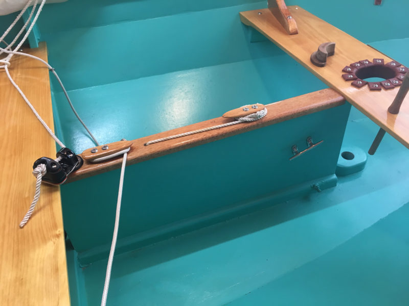
One unusual feature in an otherwise quite standard lug rig is the sheeting arrangement, which runs through a single block with a line which is looped over a thumb cleat on the leeward rail. When the boat comes about, the block is simply unhitched and hooked onto the opposite cleat. I wondered if a rope horse wouldn’t make life easier, but Scott told me he had tried that and the current arrangement worked better. It certainly seemed the optimum position for the sheet to be in, judging by how well the sail set, though I had my doubts about how handy it would be in really windy weather.
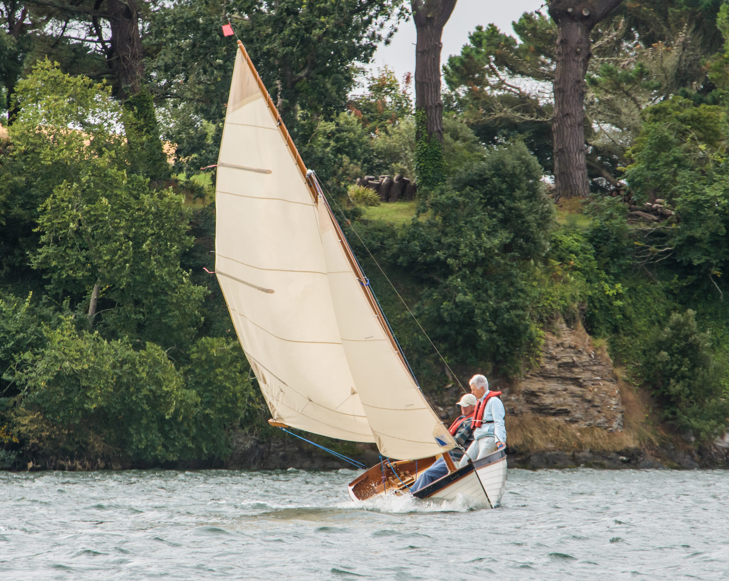
The calm conditions combined with a strong current made it hard to judge the boat’s true sailing performance during our short outing. But certainly the absence of a deep keel or centerboard will affect the punt’s windward performance, though her builder insists that, providing you sail the boat full and by (not sheeting her in too tight) it performs very well. Indeed, he suggests the sailing St. Ives punts make very good training boats for the bigger Jumbos, teaching sailors how to manage a heavy boat with only a shallow keel to resist leeway.
“There’s nothing to stop the boat going sideways,” says Jonny. “And if you sheet too hard when tacking, it will just go sideways. So, you’ve got to get way on first. As soon as you’ve got momentum, it heads up fine, and there’s no question of not being able to make it to weather.”
Lacking a centerboard, the punt doesn’t take well to being sheeted in too hard when working to windward.
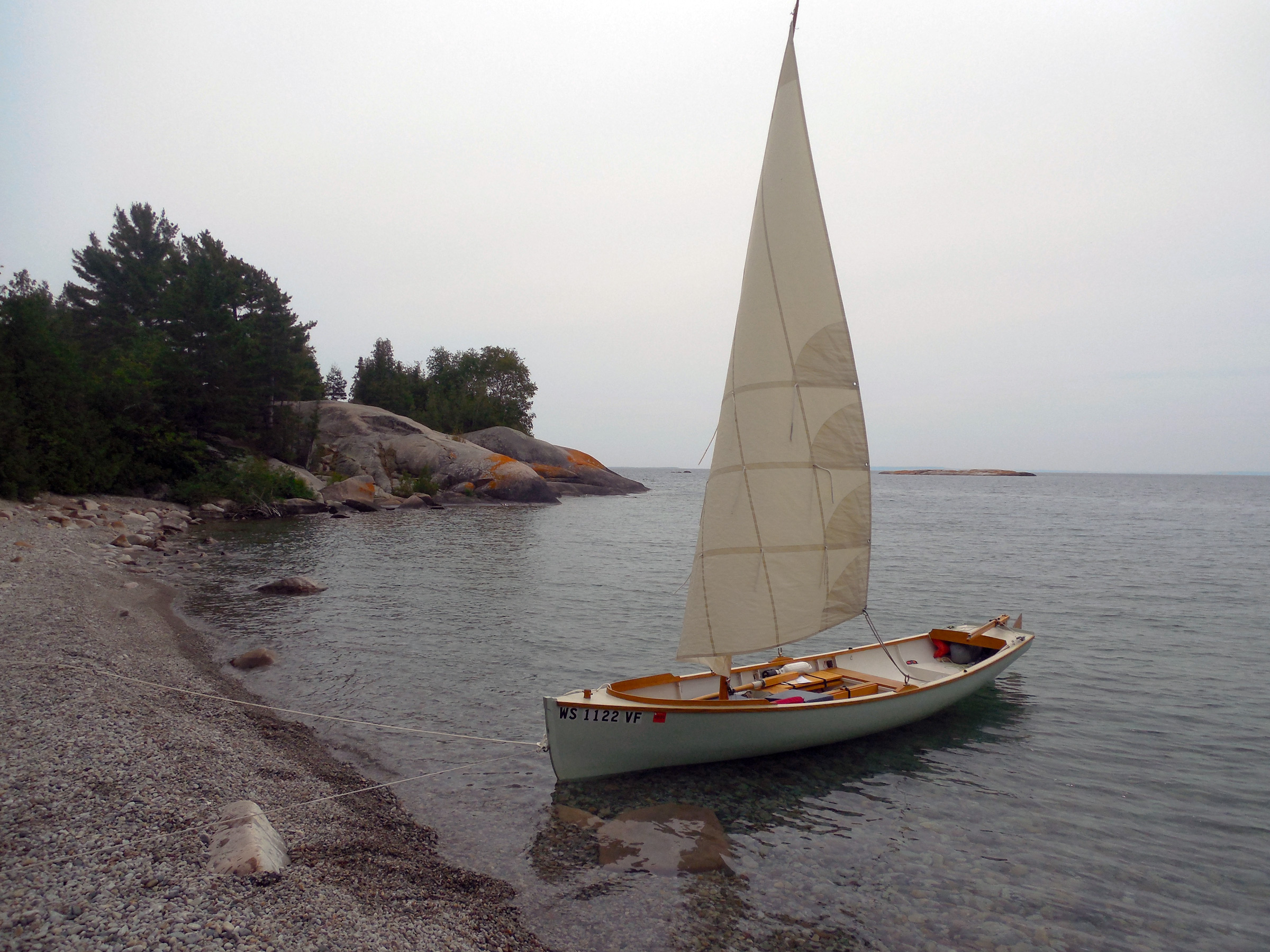
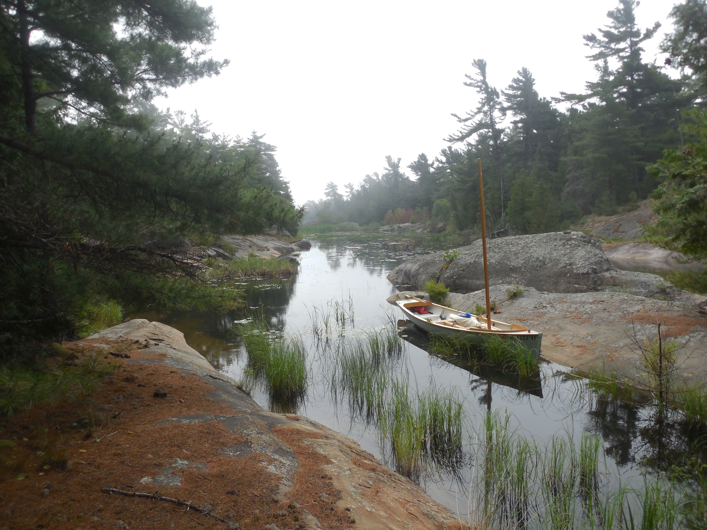
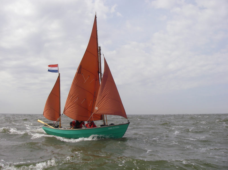
The proof of a boat is in her sailing, and MAIA certainly showed the St. Ives punt is no slouch by winning the small boat class at the Looe Luggers Regatta, in open water and against several other bigger boats, just a couple of weeks after she was launched in 2015. The following year, she won the Prettiest Boat award in her class at the Falmouth Classics regatta, proving that even a hardy St. Ives lass can win the hearts of those South Coast yachties.
So confident is Scott in the St. Ives punt’s seagoing abilities that he and his wife are planning to take MAIA gunkholing around the U.K., starting with an Old Gaffers Association rally on the Isle of Wight and then heading up to Scotland to explore the lochs. And it’s this use as an expedition boat that might give the boat a greater purpose. Not everyone wants to keep a boat on a mooring in a tidal harbor that dries at low tide, but more and more people are discovering the pleasures of dinghy cruising and coastal sailing in small boats. Although the St. Ives sailing punt is small, it’s certainly sturdy and would cope with some dirty weather.
For now, MAIA is doing a very good job moored off the jetty at St. Ives, going up and down with every tide, weathering the relentless ground sea just as her forebears did, and without breaking a single rib so far. Watching her sailing in her native waters, surprisingly nimble despite her sturdy construction, I can’t help feeling that a bigger future awaits her beyond St. Ives, beyond the Isle of Wight, and beyond Scotland even. This traditional, local design, reborn for modern times, deserves to travel the world.
Nic Compton is a freelance writer and photographer based in Devon, England. He has written about boats and the sea for 24 years and has published 14 nautical books, including a biography of the designer Iain Oughtred. He currently sails a 14’ Nigel Irens skiff and a 26’ Chuck Paine sloop.
St. Ives Particulars
[table]
LOA/11′6″
Beam/5′
Draft/11″
Sail area/75 sq ft
[/table]
St. Ives punts are built by and available from Jonny Nance. Inquire about pricing.
Is there a boat you’d like to know more about? Have you built one that you think other Small Boats Monthly readers would enjoy? Please email us!
When I retired, my wife and I decided to move from the middle of Wales to Modbury, a town in Devon, England, just 4 miles from the coast; the prospect of a move and more time on the water with my family encouraged me to look for a slightly roomier dayboat than my 14′ 6″ Oughtred-designed Whilly Boat. I spent many happy hours studying designs from France, America, Australia, and, of course, nearer home here in the U.K.
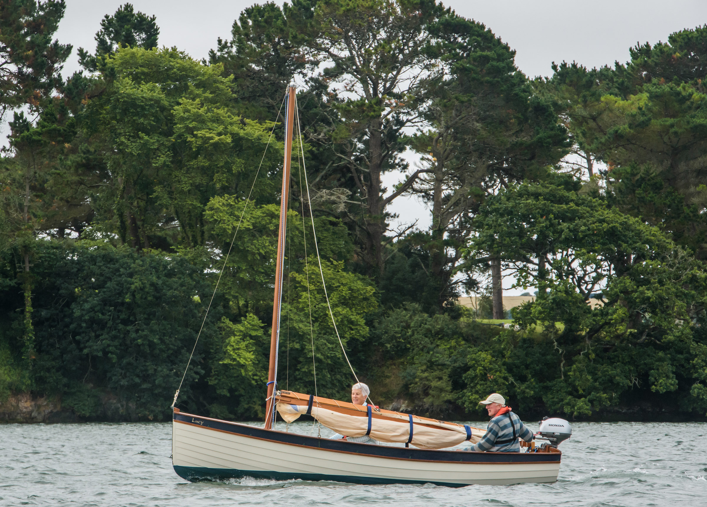
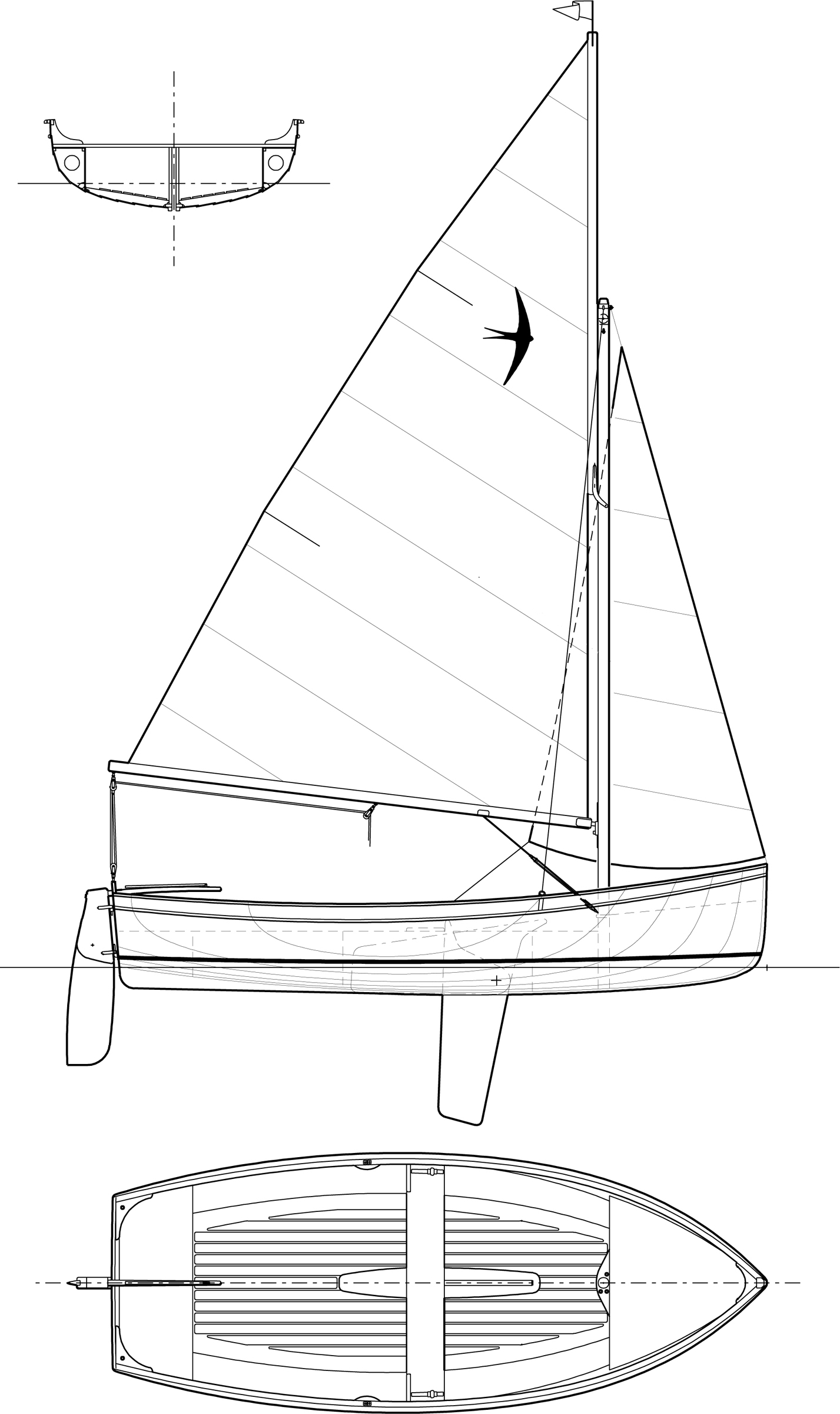
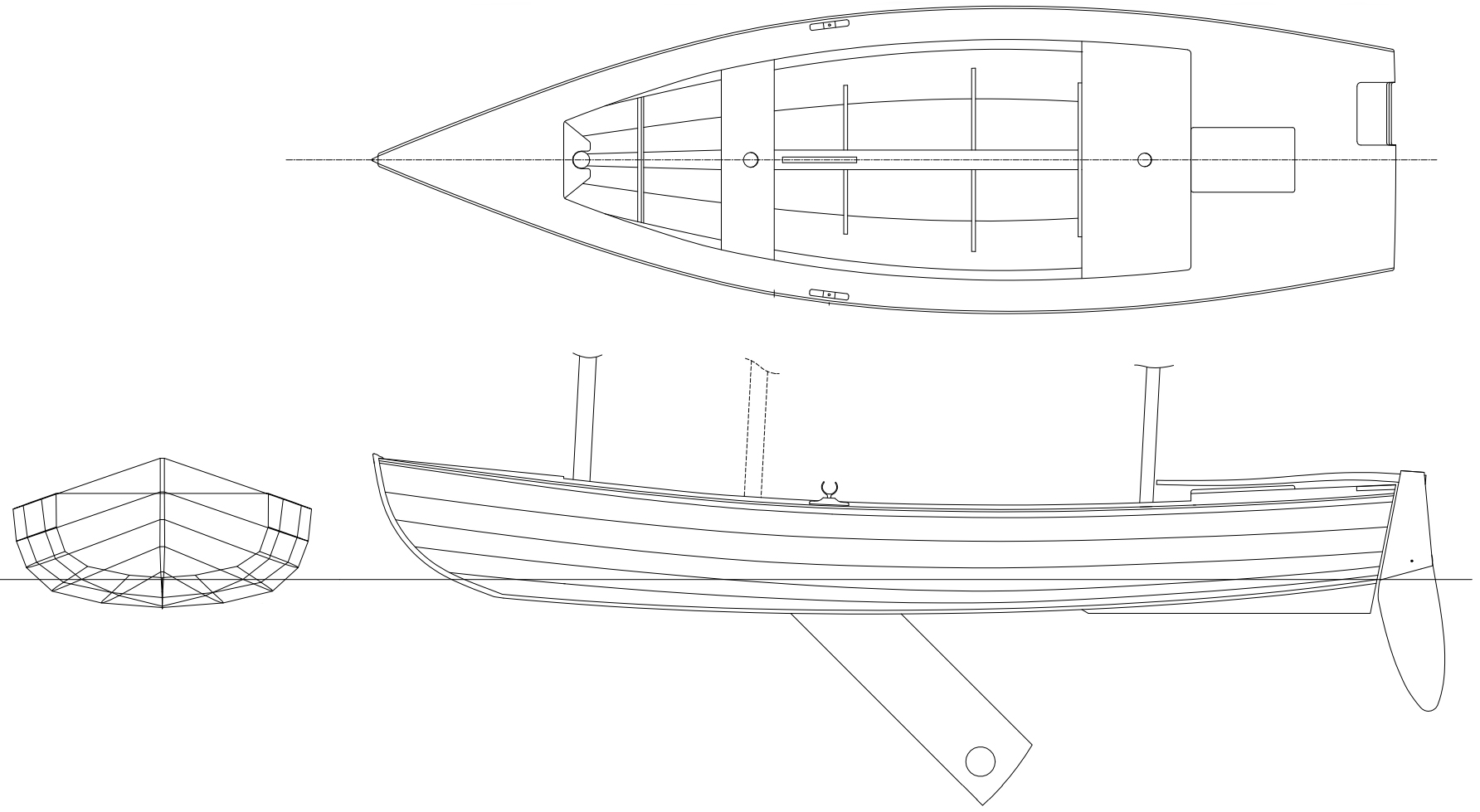
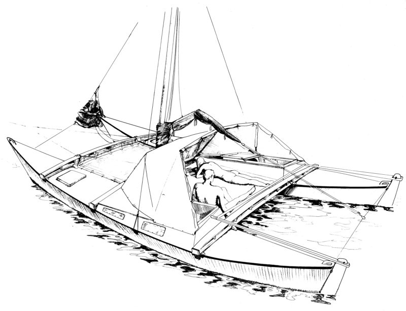
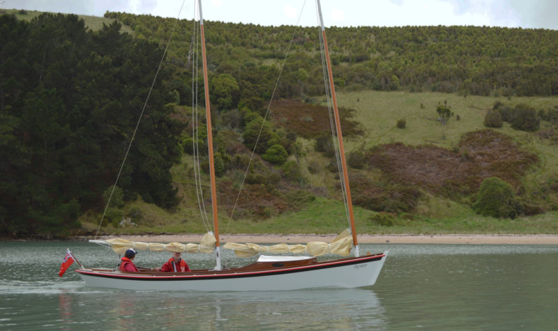
I became increasingly interested in the work of the British naval architect Andrew Wolstenholme. Two of his lapstrake plywood dinghies, the 11′ Coot and the 12′ Mallard, really caught my attention. Both were already very popular owing to their lovely lines and excellent performance under sail. I approached Andrew to persuade him to design a bigger dinghy for estuary use in Devon. The boat needed to be light enough for easy trailering but big enough to take care of itself on a mooring for the summer months. Andrew agreed and produced a set of plans for a new 15′ gunter-rigged dayboat, the Swallow.
photographs by Mike Wynne-Powell
Airtight chambers along the boat’s entire perimeter give the hull stiffness and ample buoyancy in the event of a capsize.
The lines of the Swallow seemed to offer an ideal compromise of lightness, speed, and roominess. The plans are suitable for skilled amateurs, as there are no step-by-step instructions or patterns for planks. Lofting isn’t required—full-sized patterns for the molds and transom are provided with the plans—but the hull must be lined off and the plank shapes spiled. When I realized each sheer plank might have to be scarfed together from three pieces of plywood, I asked Andrew to reduce the overall length to allow for two 8′ lengths of ply, joined by 10-to-1 scarfs, to have sufficient length for the sheer planks. Andrew agreed, and the dinghy became 14′ 6″. The straight stem and slightly raked heart-shaped transom, coupled with epoxy-glued planking, give the Swallow a very traditional appearance.
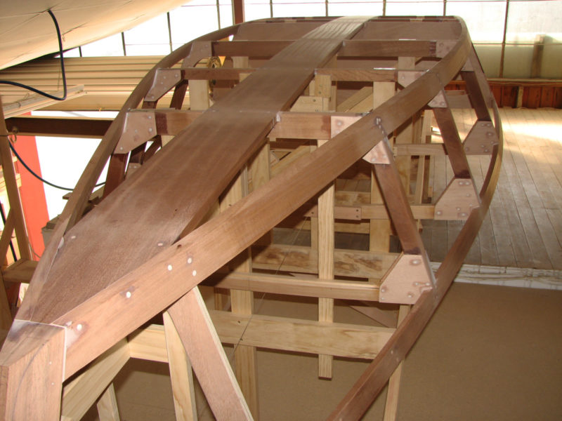
Fairing the planking lines on a new design is quite time-consuming, and I spent many hours peering at a batten laid over the hull while I tried to visualize how the boat would look when turned the right way up. The plank widths were worked out for the stem, ‘midship mold, and transom. The marks for other molds were determined by laying a batten through the known points and then marking the remaining points where the batten intersected with the molds.
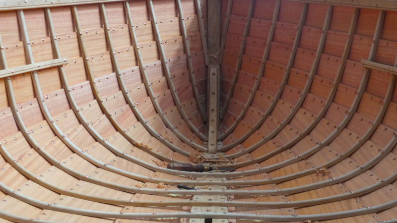
Throughout the planking process, the 13 molds kept the lightweight 6mm marine plywood fair. I sometimes used up to 30 plywood U-shaped, wedged clamps to hold each new plank in place until the epoxy hardened—they have the reach to get around the plank, cost next to nothing, and are lighter than metal clamps, whose weight could distort the planks. Each plank has a 20mm-wide beveled edge which provides ample gluing surface for the subsequent plank.
The Swallow has 10 strakes, making 20 planks to cut, trim, and bevel before fitting. The backbone is a substantial keelson in khaya laminated to a sapele keel. The 7/8” sapele transom is faceted rather than curved, so each plank end can lie on a flat beveled surface for a perfect fit. The gunwales and inwales are substantial, with three laminations of sapele sandwiching the sheer plank.
The Swallow carries a gunter main with an area of 94 sq ft and a jib with 29 sq ft.
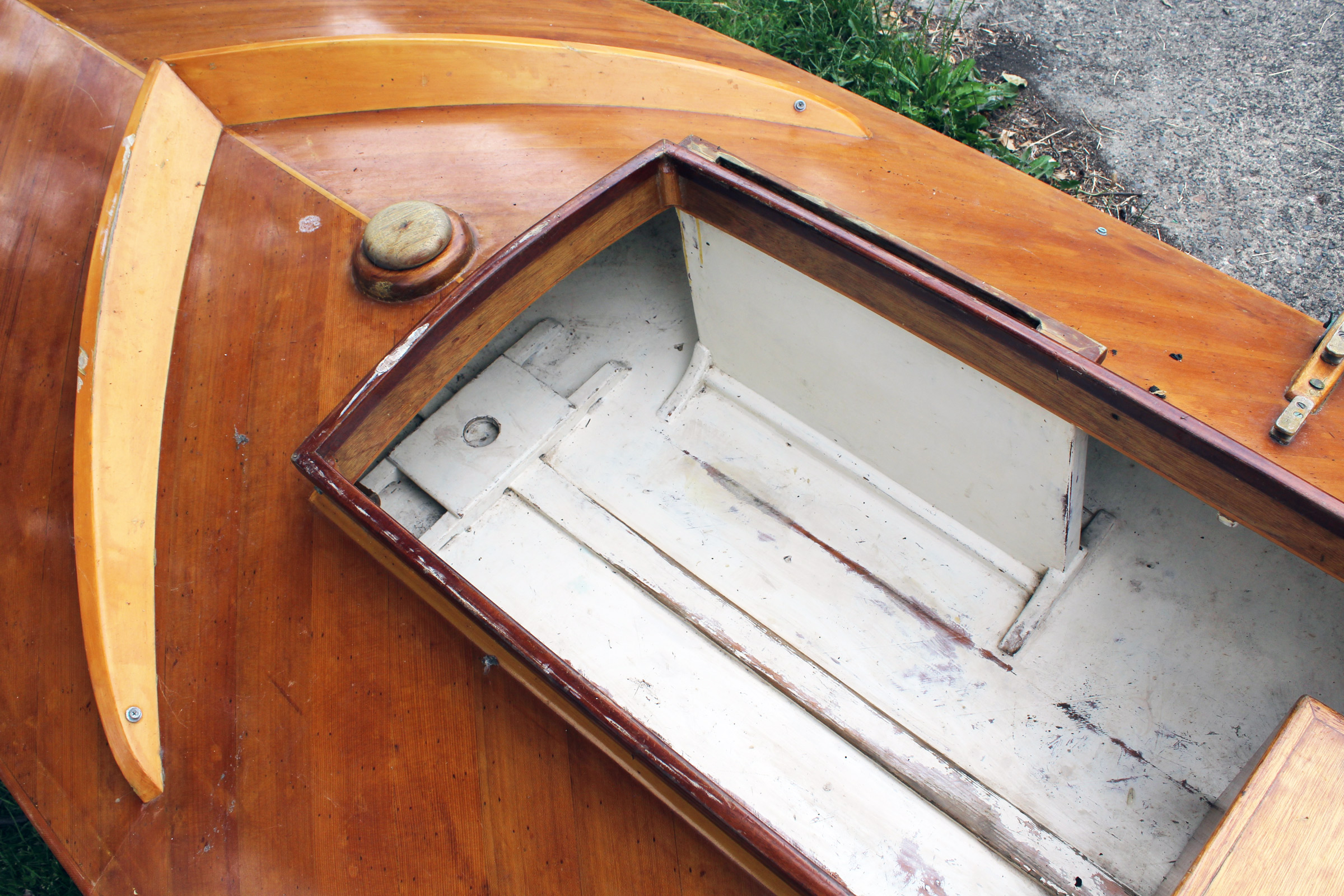
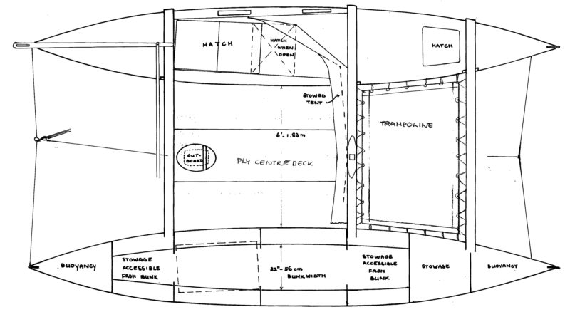
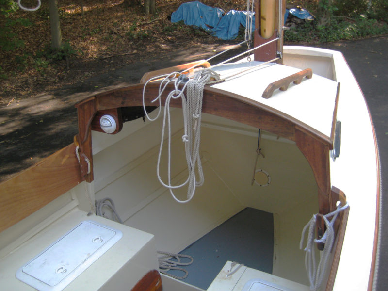
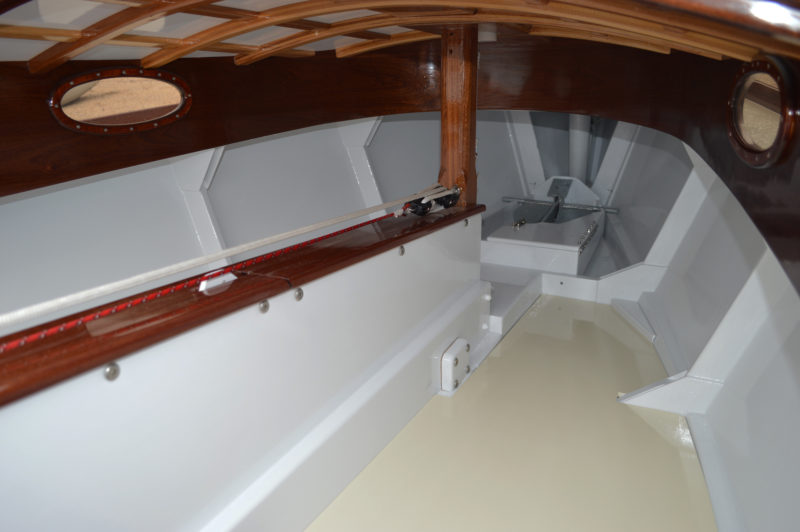
The interior layout is simple and comfortable, with the aft seat at the same height as the side benches, making it relatively easy to slide from one position to another inside the boat. The foredeck is above the bench level, but well below the sheer, and supported at its aft edge by a 12mm ply bulkhead. A large hatch on the bulkhead gives access to the watertight storage area under the deck. I stow the jib there, along with fenders and clothing. The rear compartment is accessed through two small hatches mounted on the bench and is used for stowing cordage, a chart, outboard motor parts, and safety equipment.
A pair of longitudinal buoyancy chambers span the bulkheads in the bow and stern and are fitted with removable hatches for ventilation and access. These chambers greatly increase the rigidity of the hull and comply with the EU Recreational Craft Directive regulations on safety. A pair of 7/8″ sapele knees at each bulkhead and at the center thwart secure the gunwales strongly to the hull. The centerboard case is topped by a 6″-wide 1/2″ plank, forming an additional perch in the middle of the boat. A 3’-deep swinging centerboard was fabricated from edge-glued sapele and carefully worked into an efficient foil from the plans. A 3” lead disc, epoxied in, provides some slight negative buoyancy. The nicely profiled kick-up rudder, offered in the plans as a full-sized pattern, is controlled by an uphaul and downhaul. The tiller projects from the rudderhead through an elliptical hole in the transom.
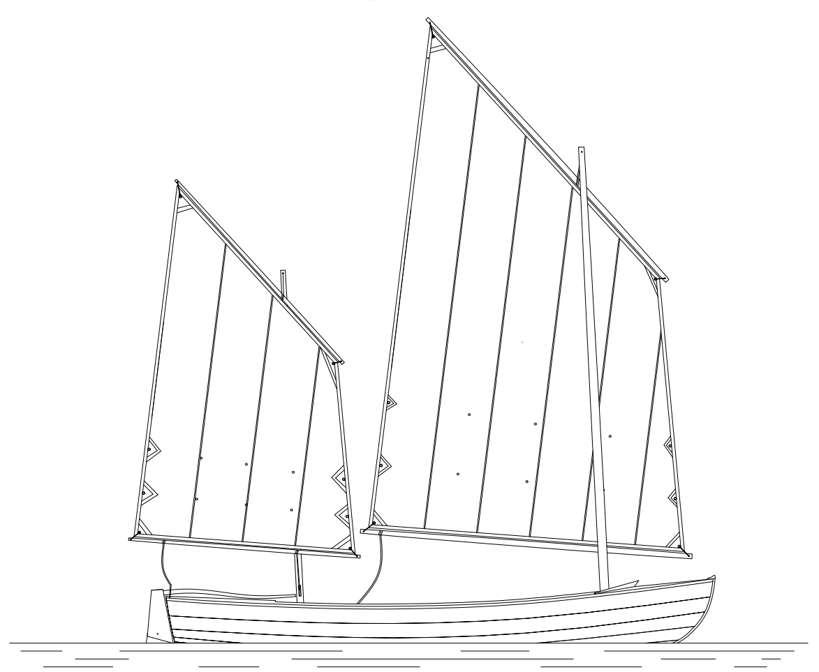
The boat carries a gunter rig, and the spars for the tall mainsail stow within the length of the boat. The mast is supported by two shrouds and a forestay. The plans call for a mast set in a tabernacle, but I opted for a strong bronze hinge. In raising the main, the yard is pulled tightly and parallel to the mast, in effect acting as a Bermudan rig. During windier conditions, the yard can be lowered about 18″ for attaching the main halyard with a quick-release pin to a second, higher slot on the yard when the sail is reefed.
Shrouds to the masthead support the rig when the Swallow is sailed hard.
Under sail, the Swallow is very responsive and light on the helm. The underwater profile of its hull not only gives a good turn of speed but the well-rounded shape, with a beam of 5′ 6″, is very stable when being boarded or sailed. There is room enough for up to four adults; with an agile crew of two aboard, the Swallow can be sailed very fast under full sail. On the Salcombe estuary in Devon, in a wind of Force 3 to 4, my wife Linda and I managed to keep completely dry despite the choppy conditions.
When sailing single-handed, the helmsman is provided with the main halyard and centerboard adjustment to the starboard of the centerboard trunk. A boom downhaul, with a 2-to-1 gun tackle to tighten the luff, leads to a cam cleat on the port side of the trunk. The Swallow sails wonderfully under main alone when going solo. I have experimented with leading the mainsheet to a block anchored on the centerboard trunk, but prefer handling the mainsheet as it comes from the boom end in the present arrangement. A kicking strap could be added to prevent the boom lifting, but I prefer less clutter. In recent years, I have fitted an auto ratchet block on the end of the boom to take the load in windy conditions. The mainsheet is led from the boom end around a block attached to a 2′ traveler on the transom.
With a beam of 5′ 6″, the Swallow needs long oars. The pair here are 9’6″.
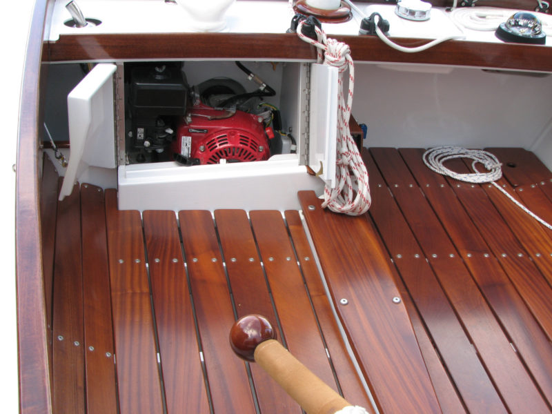
The Swallow has a single rowing station at the center thwart and, with 9′ 6″ oars, rows with ease, but I stopped carrying oars some years ago and use an outboard for auxiliary power. I stow a Honda 2.3 outboard on the port side horizontally under the center thwart over a wooden block that protects the larch floor boards. To use the motor, a special two-piece plywood mounting fits over the transom, covering the hole for the tiller and protecting the mainsheet traveler. The outboard is then quickly clamped on the centerline and can be used in minutes. The motor powers the boat so easily that I rarely get to half-throttle.
With the rudder removed, the Swallow will take a small outboard for auxiliary power. Half throttle is all it takes to get the boat up to speed.
Over the past 14 years, I have appreciated and enjoyed Andrew Wolstenholme’s timeless design for the Swallow—a traditional-looking dinghy which could happily sail in the lightest airs. I had originally wanted a dayboat that was roomy with easy lines and ideal for exploring the estuaries of South Devon, but I got that and so much more.
Nick Hanbury was a cartographic surveyor with Ordnance Survey, Great Britain’s mapping agency, and spent all his working life making maps. In 1992, he joined John Kerr at his boatyard in West Wales for a week and was introduced to concepts of lapstrake building. In 1997, Nick’s Whilly Boat won the Amateur Shipwright Award at the Wooden Boat Show at Greenwich. His Swallow, christened LUCY, went to the Boat Show at Beale Park in 2004 and won 3rd overall and special prize for Best Constructed Boat. He is grateful to Linda for her support during these projects. He’ll be happy to share more about his building and sailing experience through correspondence directed to [email protected].
Swallow Particulars
[table]
Length/14′ 6″
Beam/5′ 6″
Draft, board up/7.5″
Draft, board down/3′ 9″
Sail area, main/94 sq ft
Sail area, jib/29 sq ft
[/table]
Plans for the Swallow are available from Wolstenholme Yacht Design for £125 ($162 USD) for e-mailed PDF files, and printed for an additional £20 ($26 USD) plus shipping.
Is there a boat you’d like to know more about? Have you built one that you think other Small Boats Monthly readers would enjoy? Please email us!
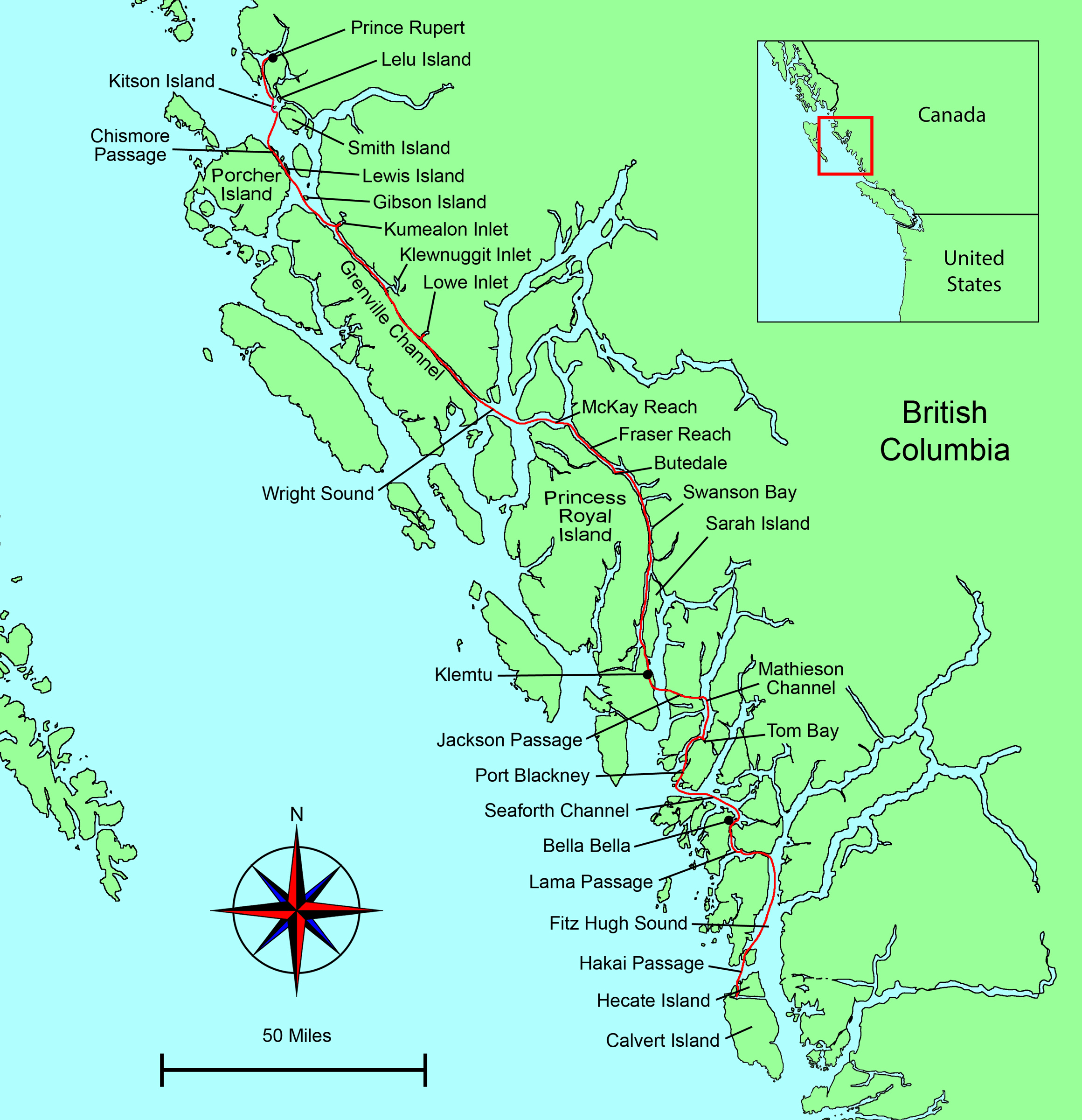
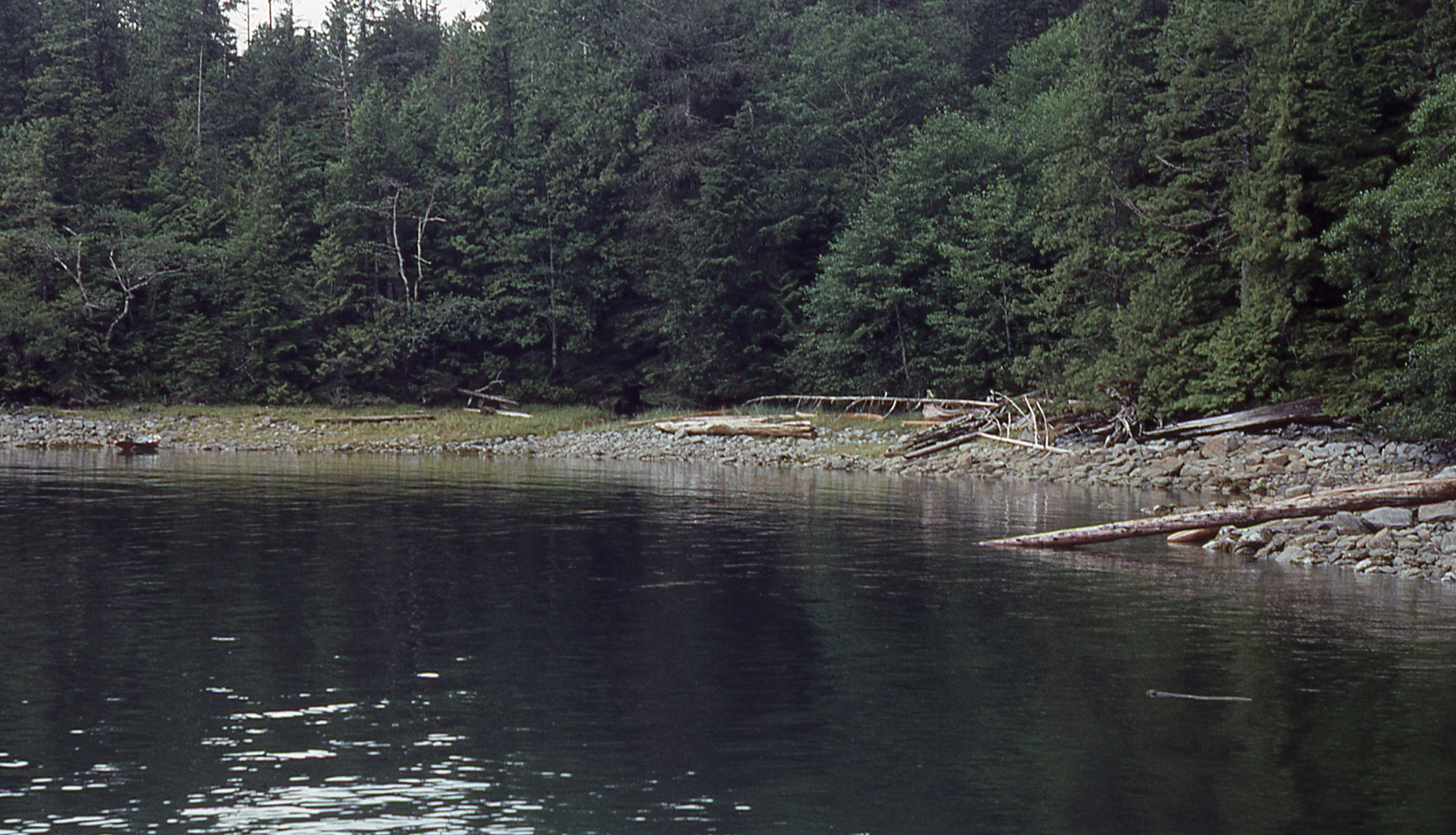
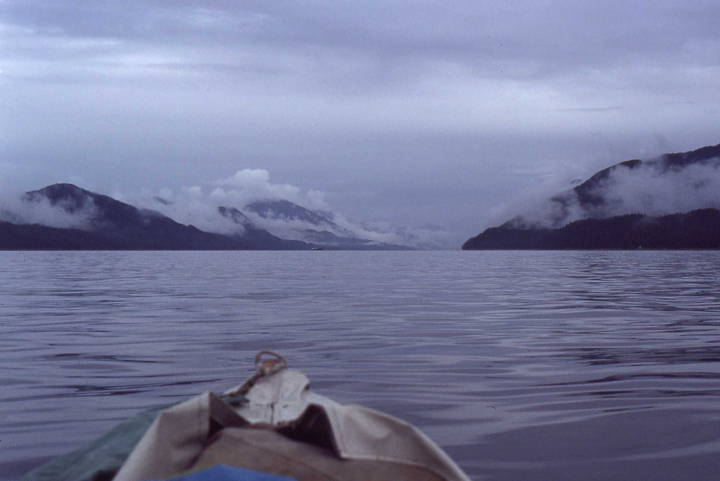
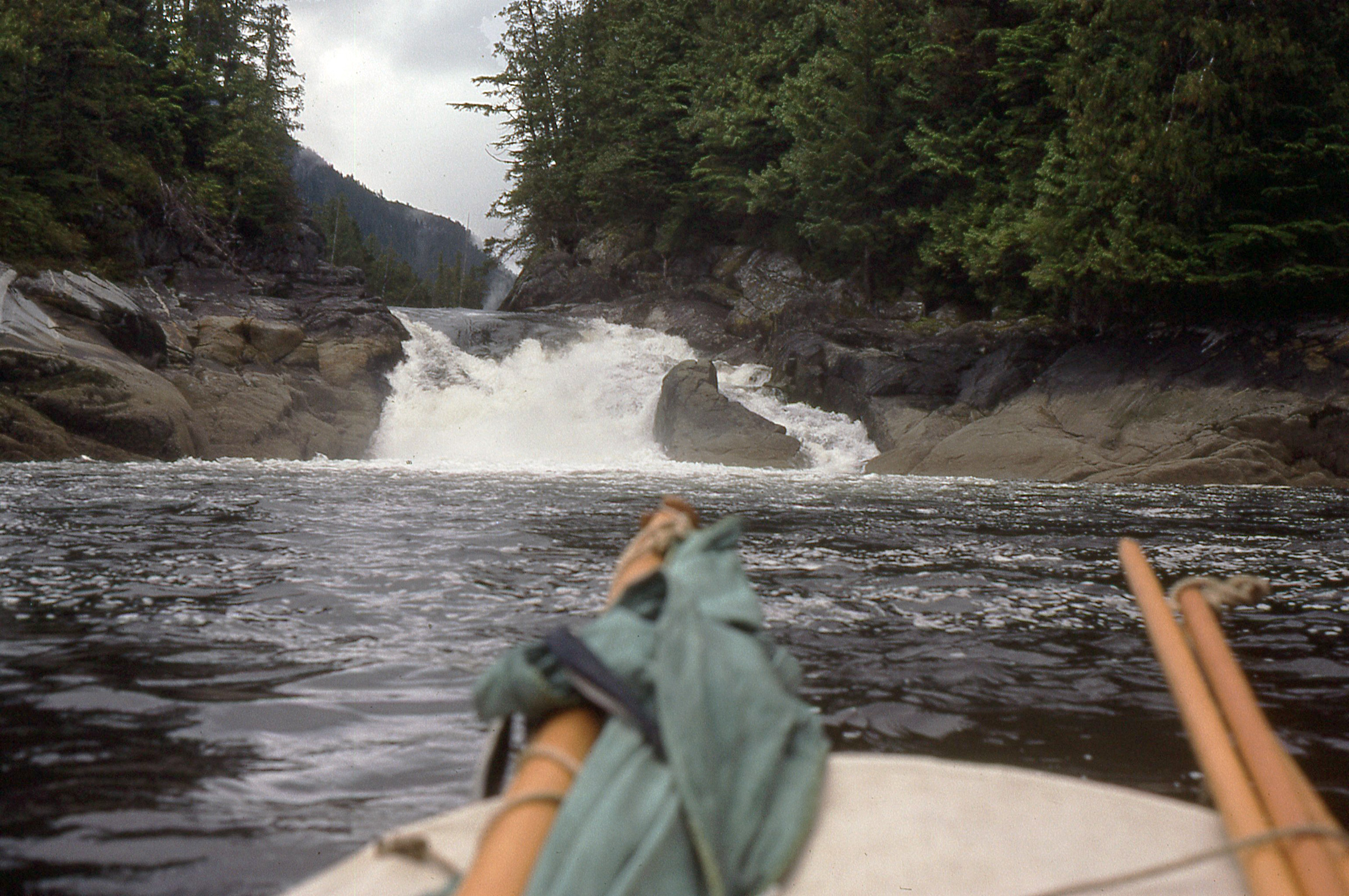
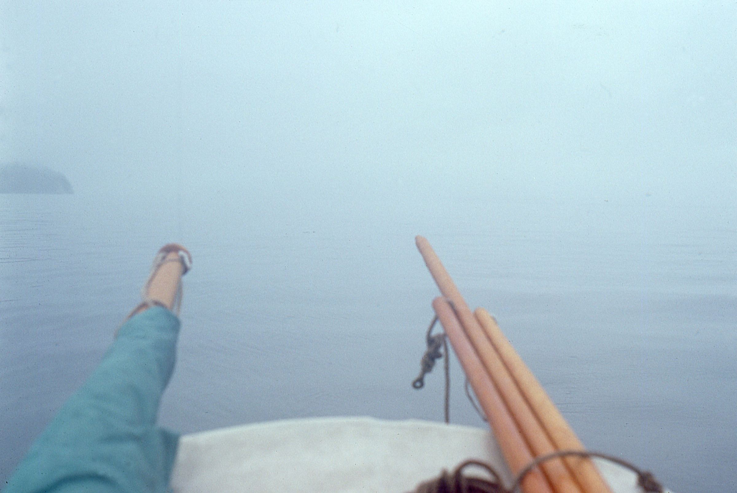
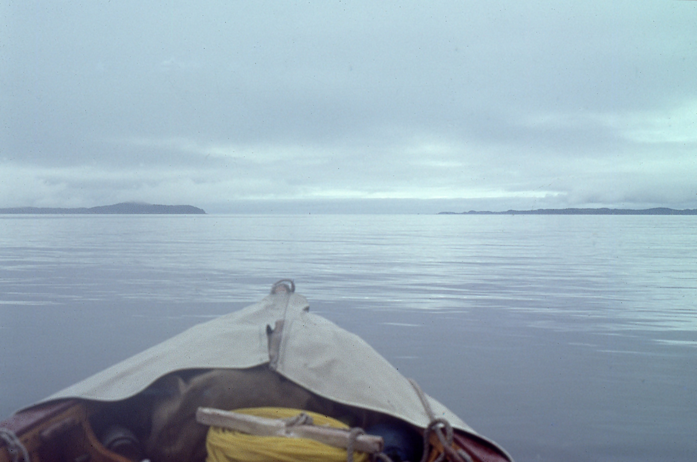
It was still dark when I woke, and all of Calvert Island and the anchorage it surrounded were eerily still. I shifted my weight and GAMINE moved with me. We were still afloat. Above the gunwales, the faint light of early dawn had just separated the sky from the silhouettes of the forested hills. I drifted in and out of sleep for another hour and when I sat up, beads of dew trickled off my bivi bag. With RAINBOW gone, I was alone in Pruth Bay, a cruciform inlet with three half-mile-long coves at the head of its entrance to the east. I was cold and rowing would be the quickest way to warm myself, so I prepared to get underway before breakfast. As I reeled the anchor in, the rattle of the chain against the gunwale echoed across the bay.
Photographs by the author
Ward Channel was quite still and GAMINE’s wake was the only thing disturbing the water. I couldn’t bring myself to row fast any more than I’d break into a run in a cathedral.
The 4-mile row to the north end of Calvert Island brought me to Hakai Pass, its waters rising and falling with the ocean swell as gently as the chest of someone still asleep. I made the crossing in about an hour and entered Ward Channel, a 1-1/2-mile-long alley just a few hundred yards wide. The swell diminished and the black water along the shore mirrored the band of gray rock beneath the trees; the closer to shore I rowed, the harder it was to distinguish the presence of water from emptiness. A raven flew by dozens of yards away; I could hear the faint crinoline rustle of its feathers.
I entered Fitz Hugh Sound where it was about 5 miles across to the mainland shore, and felt the beginnings of a southerly breeze. It filled in, pleating the water a darker blue, and I raised the mast and set sail in the first following wind I’d had in two weeks. I was making fair progress with the main and jib set, but I thought I could do better by raising the light nylon boom tent as a spinnaker. I had threaded the end of a halyard through the webbing loops on one end of the tarp when I heard the hollow rush of a whale’s exhalation.
Forty feet to port, a long, low streak of black broke the water’s surface. A low knuckled fin, traveling the length of the streak before submerging, identified the whale as a humpback. I pulled the tarp aloft and it bellied forward opposite the main. The wind continued to freshen and GAMINE churned northward, making quick work of Fitz Hugh.
Roger Siebert
.
I turned west into Lama Passage. There the wind was against me, but I felt strong even rowing 5 miles against the chop to Canal Bight, a twin-lobed cove on the north side of the pass. I’d covered more than 33 miles since leaving Calvert, but I’d sailed most of the way and had had a long break from rowing with my stay at Port Hardy and sailing with RAINBOW. I put GAMINE ashore to cook dinner and thought I’d spend the night at anchor, but the bight was not protected from southerlies. There were two nooks tucked around corners that would be safe if the wind came up during the night, but both would dry out with the early- morning low tide. The air was still and to the west the warming amber tones of sunset silhouetted the lacy fringe of tree line that surrounded me.
It was almost 9 p.m., but only 5 miles lay between me and Bella Bella. The tide would carry me northward and the gibbous moon, gleaming in the indigo sky to the east, would light the way. I rowed around Twilight Point, appropriately, at twilight and as I turned north the moon’s reflection splintered in the ripples of my wake. A seiner, southbound, slowed and came alongside; the skipper, having seen my light, asked if I was okay. I replied, “Yes, thanks, I’m doing great.”
When I reached Bella Bella, I tied up at the end of one of the two docks, hiding beneath the ramp to the pier a dozen feet above. I thought I’d be safe there, tucked out of the way, but after I had rearranged the boat for sleeping, a group of teenagers, judging by the sound of their voices, tromped down the ramp. Two of the boys among them were there to have a fight; the rest came to watch. All the shouting and goading was making me a bit anxious, so I quietly packed up, slipped my lines, and rowed away through the pilings beneath the pier.
A few dozen yards to the south, I found a mooring buoy and gambled that the owner wouldn’t be needing it that night. Dew was beading up on the boat and my gear, but I warmed up as soon as I was in my sleeping bag. The fights on the dock were still going on and I heard another similar commotion to the north. Around midnight the waterfront lapsed into silence and I was able to sleep until 4 a.m., when there was yelling and swearing again coming from the pier.
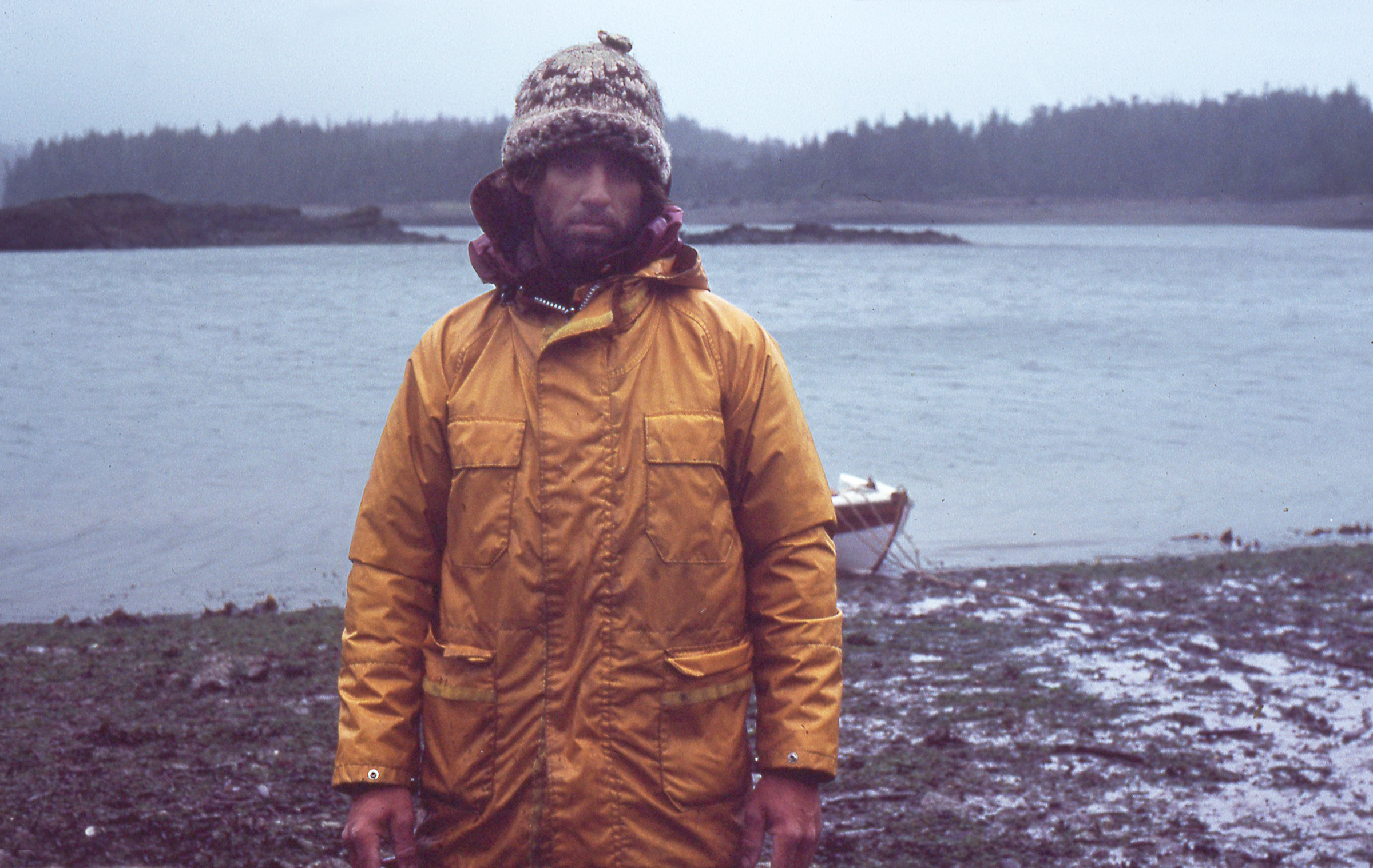
At daybreak, Bella Bella was at peace as a man in a red-and-black plaid coat rowed a diminutive plastic dinghy out to one of the fishing boats moored near GAMINE. I said good morning and introduced myself; he returned the greeting, identified himself as Kelvin, and invited me to come ashore for a cup of coffee. He rowed over to pick me up, but when I stepped aboard the dinghy, which was full of holes, it started filling with water. I tied a long line to it so he could go ashore first and I could pull the dinghy back out for my turn.
Kelvin’s house, built on slender stilts over the intertidal, was a short walk along a weathered boardwalk with several planks missing. His living room was well kept, with shag carpet and dark paneled walls, decorated with only a framed photograph of a young girl—his daughter—and a painting of Jesus. As we sat at the kitchen table with a plate of homemade bread his wife had made that morning, the washing machine, running just outside of the kitchen, went into a spin cycle and the whole house shook as if an earthquake had rumbled under Bella Bella.
The southerly that had helped me get to Bella Bella brought clouds, and when I left it began to rain. I sailed under the boom-tent spinnaker to Seaforth Channel. Visibility in the rain and mist was poor, but I was always able to steer clear of fishing boats and cruise ships and make out the landfalls along the north side of the channel. GAMINE was moving well, but sitting in the stern, inactive, I was getting chilled. My nylon rain jacket was saturated with rainwater and pressed heavily against my back and shoulders. The cold seeped through, at first numbing my hands and arms, then making me shudder. I lowered the rig, set the oars between the tholes, and began to row, waiting for the exertion to warm me.
Port Blackney wasn’t the refuge I’d expected it would be. GAMINE is tethered at the far left and somewhere behind the thick wall of trees there is an old log cabin being consumed by the rainforest.
After 3 miles under oars I turned north-northeast into Reid Passage, a 170-yard-wide channel separating Cecilia Island from the mainland peninsula it parallels. At the north end of the passage was a place marked on my charts as Port Blackney. I expected to find a harbor of some sort where I take shelter and warm up. What I found there, nearly invisible in the dark woods along the south side of the cove, was a one-room cabin, its log walls cinder-black with decay and its roof swaybacked under a thick layer of moss and duff fallen from the cedar trees that loomed over it.
My hands showed the effects of spending 10 hours in the rain. My sense of touch was quite dulled, and in the evening I had to dry the skin over my camp stove before I could use my hands less clumsily.
Worried that the cabin might yet appeal to bears or wolves, I resumed rowing along the mainland shore and made my way to Mathieson Channel. I had covered about 25 nautical miles when I pulled into Tom Bay to anchor for the night. It had been raining the entire time I’d been underway, and my hands had been wet for 10 hours. My palms were as rough and almost as white as raw cauliflower. Every fingerprint ridge was in high relief, and where rowing had peeled away a layer of skin there were craters surrounded by ragged edges. I could scarcely feel anything with my fingers, and I fumbled with the tarp, getting it stretched over the cockpit. Before I cooked dinner, I held my hands above the stove until the heat rising from its blue flame brought them back to normal.
The ride up Mathieson Channel went quickly with a benevolent tailwind, though the rain and gloom were dragging me down.
In the morning I woke well before sunrise as the first light was sifting through the fog and drizzle. I was under way at 5 a.m., dreading another day of being cold and wet, but again needing to get moving to warm up. There was a good following wind in Mathieson Channel, strong enough that I set only the mainsail to drive GAMINE north the 7 miles to Jackson Passage. Flanked by 1,000’-high ridges, the nearly 6-mile-long east–west passage spans not quite a half mile in a few places, but most of it is just a few hundred yards wide.
After I’d been rained on for the best part of two days, the mist began to lift over Jackson Passage. During the trip, I took very few photos of myself from a distance. The camera’s self timer gave me only 10 seconds to get into the frame and running across seaweed-covered rocks in this little cove off the passage was flirting with injuries I could ill afford.
There was no wind in the steep-sided landscape, so I brailed the main and rowed. Cedar trees, growing thick just above the water, had their lowest boughs evenly trimmed by the tides, like an orchard grazed by deer. The rain had stopped, and the water was dark and as smooth as oil. While the sky was still overcast, far to the west, beyond the end of the passage, the sun had reached through an unseen gap in the ceiling, setting the overlapping ridges of Swindle Island aglow and dappling them with the shadows of clouds.
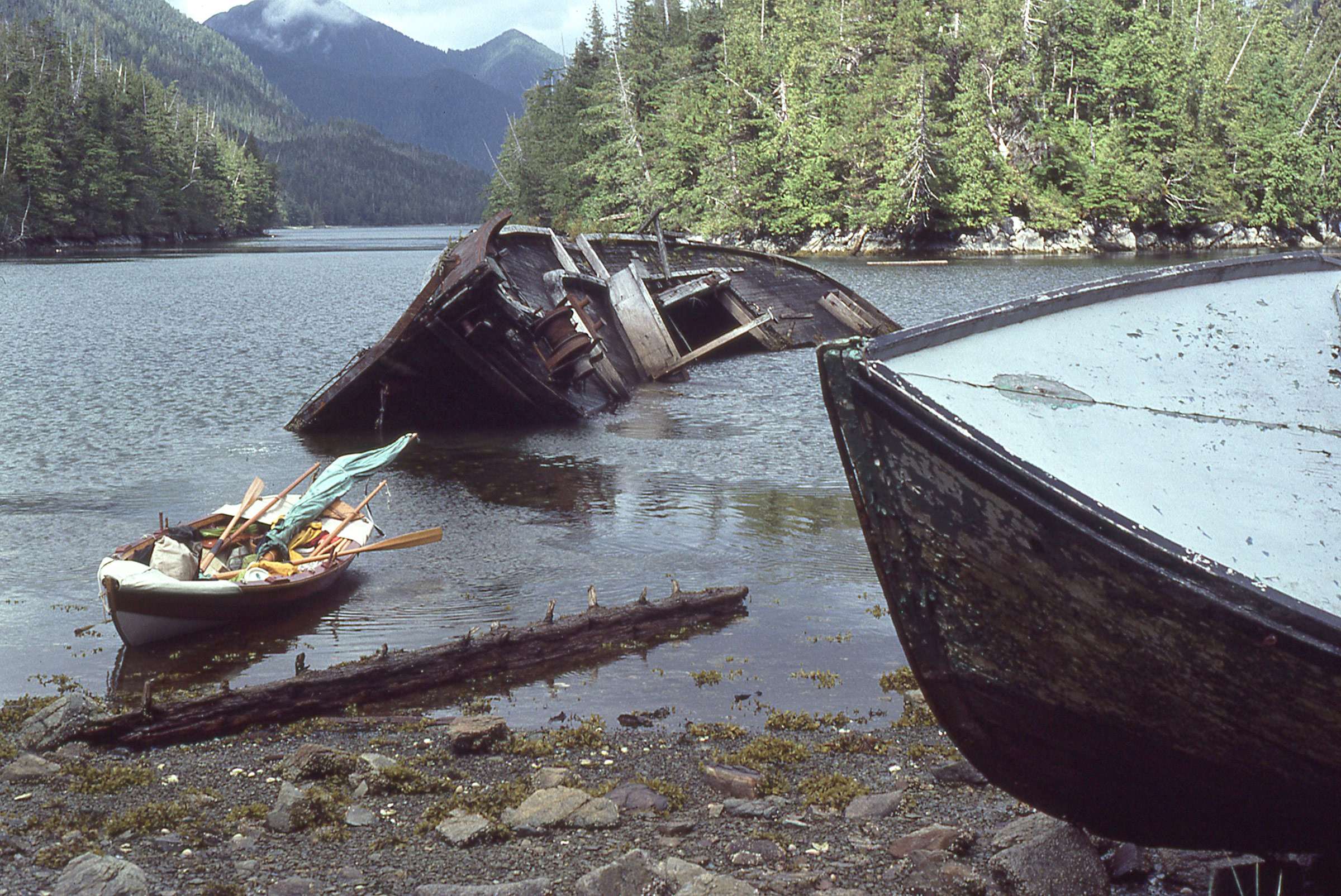
When I entered the channel that led to the village of Klemtu, I found a cove that seemed to be where fishing boats past their usefulness were left to die.
When I emerged from Jackson Passage there was a westerly on Finlayson Channel, so I dropped the bundled mast, mainsail, and sprit and began rowing across to Swindle. In mid-channel I passed a blue plastic tarp floating at the water’s surface. Thinking it would help me get through another spell of rain more comfortably, I fished it out of the water and tucked it away.
Klemtu was a small native village, home to about 200 people and accessible only by boat. Running in front of the houses at left and toward the white building at right is an elevated boardwalk that served as the main street.
Klemtu was a small village with a single row of white clapboard houses arrayed along the curve of the shoreline, and a boardwalk set on pilings over the intertidal zone and serving as the village’s main arterial. I stopped long enough to buy some apples and cookies at the grocery store, and was underway again at 3 p.m.
In the late afternoon a northwesterly arose briefly, staying only long enough to sweep the dull gray overcast. With the sky cleared and the air stilled, I kept rowing well into the evening. The moon rose above Sarah Island and lit my way along Tolmie Channel to a narrow inlet on Princess Royal Island. About 200 yards in, I stopped rowing and GAMINE slowly drifted backwards in what had to be the outward-flowing current of a river. I could hear fish jumping and guessed that salmon were heading to the river to spawn.
It had been a very long day—I’d covered 33 nautical miles since leaving Tom Bay—and I needed a good night’s sleep, but when I settled into my sleeping bag it was still wet from the rain two days ago. It took a long time to get warm, and I kept worrying that GAMINE would drag anchor and drift into the traffic in Tolmie Channel. The repeated knocks of salmon running into GAMINE’s hull made it that much harder to get to sleep.
I did nod off eventually and slept so soundly that I missed my alarm in the morning. When I woke I could still hear the salmon on the move, but instead of splashing, they were making a swishing sound like an oar blade pulled only half submerged. Then a sharp rap of wood against rock shook the boat. I bolted upright and saw the water was only inches deep; the salmon barely had enough to cover their backs. I was surrounded by fins. I got dressed quickly in the chilly morning air, hauled the anchor aboard, and let GAMINE drift into deeper water.
I’d rowed only about 4 miles to the north when several packs of 10 to 15 southbound commercial trollers rushed by, pushing piles of white foam at their bows. I took some wakes bow-on and rowed through them, but others were so high and steep that I had to lunge for the stern sheets to raise the bow enough to keep from spearing through them.
I stopped to stretch my legs at Swanson Bay on the mainland side of Graham Reach. There had been a pulp mill there, built around 1900. All that was left were a towering square brick chimney and the ruins of two concrete buildings, one with a pair of squirrel-cage fans 8’ in diameter at the base of rusted metal bars five stories high.
Marked on my chart was the point where the tides meet behind Princess Royal Island, and I rowed toward it from Swanson with the last of the flood, anticipating the ebb would carry me the remaining 10 miles to Butedale. But a northwesterly wind had given the flood tide flowing in from the north end of the island enough momentum to continue flowing south during the ebb. With wind and current against me, I had a long hard pull to get to Butedale.
I hiked to Butedale Lake on the steep boardwalk built alongside the wooden pipe supplying water to the generator that provides electricity to all of the buildings. A wrapping of wire kept the tarred staves from bursting under the pressure.
Tucked in a 1/3-mile-wide cove and built up against the steep slope of Princess Royal Island, Butedale was built as a cannery and was in operation for three decades before being shut down in ’50s. When I arrived, almost all of the buildings for fish processing and the residences for the workers were empty, but the general store, a two-story white clapboard building at the top of the ramp angling up from the dock, was still open for business. Dan, the man running the store, was a Seattlite like me, and he had just bought Butedale, all 72 acres along with the houses, the dining hall, a bunkhouse, the fish-packing buildings, and the hydroelectric plant. I bought an ice cream sandwich from him, and he invited me to spend the night in the bunkhouse.
I brought my gear up from GAMINE, took a long, hot shower in the bunkhouse, and made myself at home in the dining hall. I was the only one in the building, but the steam radiators were keeping it warm and the air was redolent with the aromas of old wood, paint, and linoleum. I didn’t need to use my camp stove for cooking, as I had a working institutional kitchen at my disposal.
I woke in the bunkhouse clean, dry, and well rested. A southeaster had moved in during the night, bringing rain. I was in no hurry to leave and the tide wouldn’t be in my favor until midday, so I took a walk around the village. Lights were on everywhere, even in the unoccupied worker houses. The turbine driving the electrical generator was always spinning, driven by water from Butedale Lake descending through a tarred wood-and-wire pipe 3′ in diameter. To keep the turbine at a safe rate there had to be a constant load on the generator from the electrical grid.
At noon, I left Butedale and rowed into a confusion of chop as two sets of waves were met at right angles to each other and bounced off the shore’s near-vertical slabs of bare rock. In Fraser Reach, a 12-mile-long furrow between ridges on either side rising from the water in uninterrupted slopes as high as 4,000 feet, the wind picked up, so I set the main and jib. GAMINE took off down the channel. Rain was seeping through leaks in my foulweather gear, so I wrapped myself in the blue tarp that I’d picked up in Finlayson Channel.
As I was settling in on the stern sheets, an errant gust slipped in behind the main. I ducked under the boom as it slammed across, but the sheet snapped tight across the back of my neck and pinned me on the now leeward side. Wrapped in the slippery wet tarp, I couldn’t get much traction and had to scramble to get my weight to windward. I managed to get to the high side before any water could come pouring over the rail; when I got GAMINE settled on the new tack, she made great speed, and the white-veil waterfalls draped over the steep flanks of Princess Royal Island raced by.
I rounded Kingcome Point at the intersection of Fraser Reach and McKay Reach and coasted into the island’s lee. A 1-mile row brought me into a cove that would be protected as long as the wind didn’t swing around to the north. It was only 5:30 p.m. and I had covered just 15 miles, a short day. The fog had lifted, the water was silky-smooth for as far as I could see, and although I had fallen into the habit of making miles whenever I could, the next safe haven was a long way off. A mooring buoy in the cove would simplify settling in for the night and set aside my anxiety about dragging anchor, so I settled in my nest on the floorboards dry, warm, and happy.
In the wee hours of the morning, I was awakened by a dull thud that shook the boat. A drifting log had struck GAMINE and stuck, balanced across her stem. It took several hard pushes with an oar to slip it free.
The gap in the hills ahead is the entrance to Grenville Channel, a 45-mile-long corridor that funnels winds and tides.
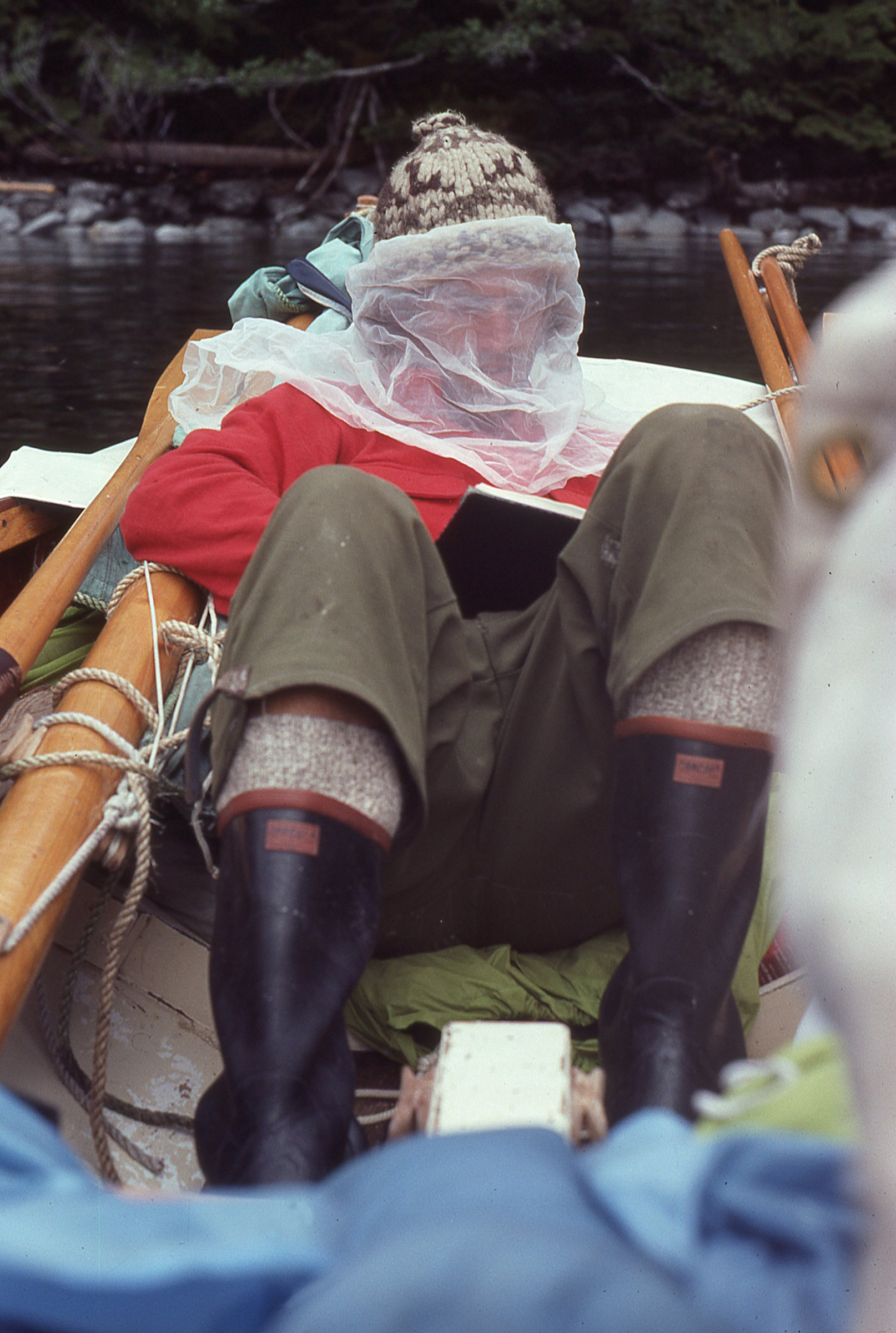
I got up at 4:30 and was under way at 5:00 under clear skies and on calm seas. I rowed with the tides in my favor and made good speed covering the 20 miles from McKay Reach and across Wright Sound. Two miles into Grenville Channel, a 45-mile-long ice-age-plowed trench between Pitt Island and the mainland, I was feeling fatigued and pulled into a narrow notch in the north shore to wait out the worst of the ebb; it would reach speeds upwards of 5 knots and make progress impossible. It didn’t take long for gnats to find me at anchor. I wrapped some netting around my head, pulled my bivi bag over the rest of me, wrote an early journal entry, and eventually lay down for a nap.
Waiting out an adverse tide on Grenville Channel, I had to wrap up in a piece of netting to keep the bugs off my face while I wrote in my journal. In cool weather I dressed in wool: heavy socks, Army surplus pants that I had turned into knickers for backpacking, a long-sleeved shirt, and a Cowichan knit hat that I’d found half buried in the intertidal sand on a Puget Sound beach.
When I woke an hour or two later, the backs of my hands were dotted with pinhead beads of blood and GAMINE was crowned with erratically circling gnats. I rowed out of the inlet as fast as I could, swinging at the bugs tucked into my slipstream. It took a mile of hard rowing to leave them all behind.
I’d been getting used to the fatigue—rowing was just what I did every day, often all day—and my hands had toughened up, but my mind was feeling the wear and worry of the travel, especially in the long channels where anchorages were scarce and adverse currents and winds were a daily struggle. September was just a few days away, and the crests of the ridges and peaks that surround the Inside Passage were now being dusted with snow. In another week I could cross the U.S. border, but as appealing as it might have been to say I had rowed to Alaska, as a goal, it had become meaningless. The scope of my concern was much narrower and more practical. Keeping warm and getting safely from one anchorage to the next were the only things that mattered.
Nettle Basin, in the farthest reach of Lowe Inlet, is quite remote but I found lots of good company there. The couple cruising with the St. Pierre dory (left) was quite generous. They brought me aboard for breakfast and before they left they gave me three big Dungeness crabs they’d caught.
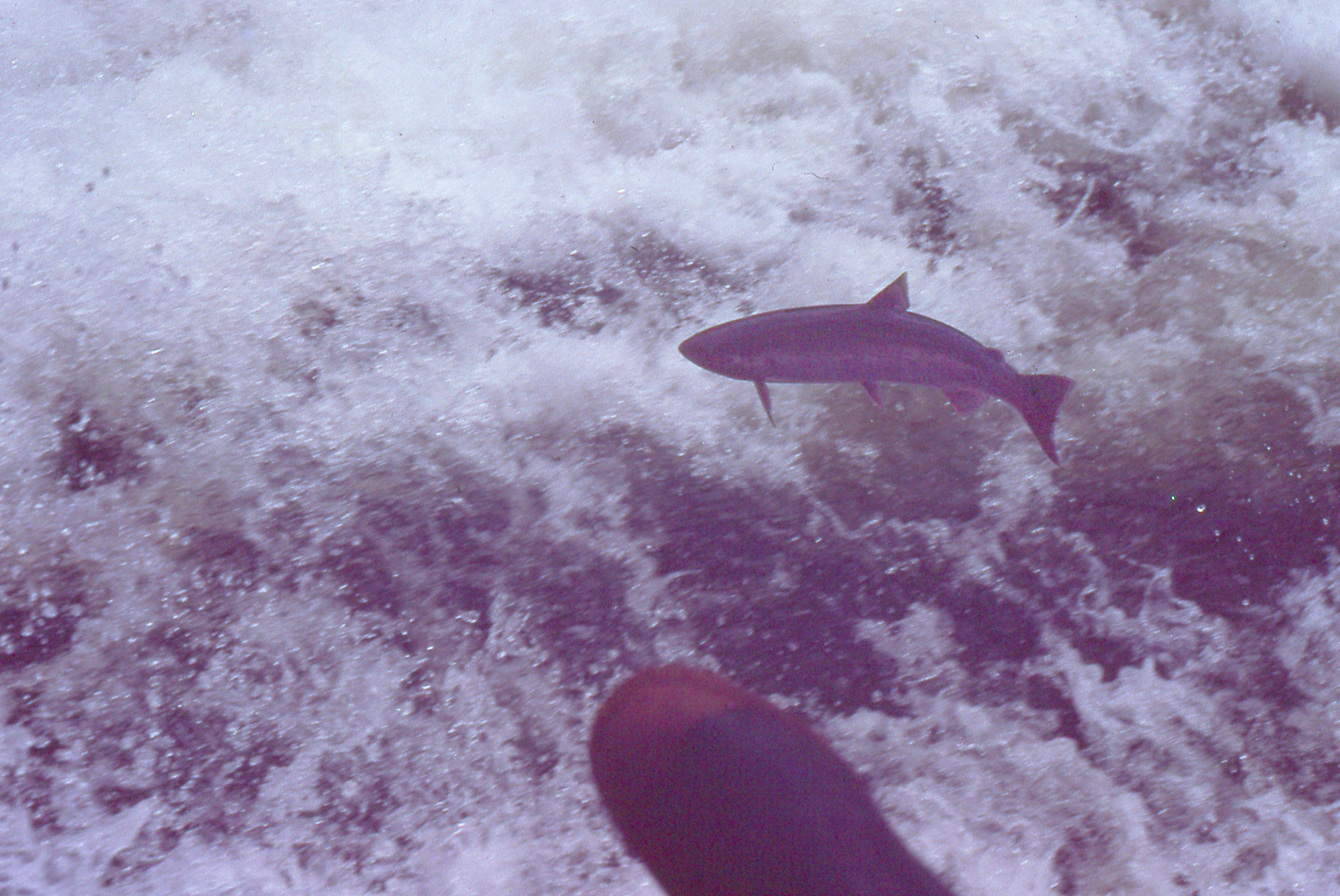
I rowed another dozen miles along Grenville, and in the mid-afternoon I entered Lowe Inlet, a 1/4-mile-wide gap in the 2,000′ ridge on the north side of the channel. Two miles into Lowe, I came to Nettle Basin, where a waterfall tumbled out of a valley in the farthest reach of the inlet. The top of Verney Falls was nearly level with the band of blackened rocks that separated the forest from the intertidal, and, with a spring high tide, the falls would be no more than tongue of dark jade water slipping quietly into the inlet.
The tide was rising when I arrived at Lowe Inlet and salmon were gathering in Nettle Basin, waiting for the peak of the tide before attempting to swim up the waterfall.
I beached the boat, carefully picked my way across the rock slope, and sat down at the edge of the falls. I had seen salmon surfacing at the base of the falls when I had approached with GAMINE, and suddenly dozens of them were darting out of the water in low arcs above the rush of whitewater, flexing their tails rapidly even though airborne. They had been waiting for the peak of the tide to help them get past the falls to their spawning grounds farther inland. Some of the salmon, attacking the falls on my side, flew by inches from my boots.
I sat watching salmon at Verney Falls for the best part of an hour. As I was doing research for this article, I found a photograph of the waterfall showing a black bear waiting to catch a fish at the very spot where I had been sitting with my back to the woods.
Nettle Basin was a popular anchorage for working vessels and pleasure craft. GAMINE, by far the smallest boat there, drew a lot of interest and generosity. A couple aboard a St. Pierre dory gave me two slabs of salmon that I cooked for dinner; the skipper of the tug LADY JODY let me spend the night in the fo’c’s’le. In the morning I was invited aboard the dory for breakfast and given three Dungeness crabs. A woman aboard a motor cruiser handed me some cookies and a banana, and a family of nine Tsimshian First Nations people invited me to join them for a beach picnic of spareribs and crab cooked over a campfire.
That second night in Nettle Basin was quite still, and rather than get ready to sleep, I started rowing out of the inlet, planning to take advantage of the nighttime tides in Grenville Channel. I rowed about a mile and had misgivings about spending the night underway; I and turned around and spent the night at the anchorage.
When I woke the next morning, black flies had found me. They were as big as raisins and their bites were quite painful. I had to wait until noon for the tides, so I pulled the bivi bag over my head while I had breakfast in bed.
I shared Grenville Channel with yachts, fishing boats, and cruise ships such as PACIFIC PRINCESS, featured in the TV series “The Love Boat.” After stardom, she got caught up in a drug smuggling ring in the Mediterranean and was ultimately scrapped in 2014.
I reentered Grenville Channel and rode the ebb tide, sailing wing-on-wing in a moderate wind. For hours I sat on one of my 5-gallon paint buckets with one hand on the tiller; I passed Klewnuggit Inlet, 11 miles along, where I got my first glimpse of the end of Grenville Channel, still some 20 miles away. I stopped in Kumealon Inlet on the north side of the channel after covering 25 miles. The anchorage was deep and the tides were running 15’ between high and low, so I asked a couple aboard a sailboat already anchored there if I could spend the night with a long painter tied to their stern, assuring them I’d be on my way at dawn. They agreed, and I made preparations aboard GAMINE for cooking dinner. I boiled the three Nettle Bay Dungeness crabs, one at a time, and ate all of them, picking them clean in 45 minutes. For dessert I had a peanut butter sandwich and two bowls of cereal.
I cast off from the sailboat at 6:00 a.m. and rowed back out to Grenville Channel. It was still early in the morning when a southeasterly funneled between the steep mountain slopes flanking it. I set sail and GAMINE again made good speed with the main and jib set wing-and-wing. The wind stiffened, making it harder to steer against the turning force of the mainsail. At the mouth of Grenville, just as I drew abreast of Gibson Island, the wind caromed off the island got behind the main; I saw the leech curl and dove for the floorboards as the boom slammed over to port. The sprit had crossed forward of the mast, raising the foot of the sail and pulling the boom jaws off the mast. Nothing had broken, and the self-scandalized sail reduced its area by at least a third and made it easier to steer.
I turned into the lee on the north side of the island to put things back to rights. I rowed the patch of slick water to a beach of rocks the size of bowling balls. After I put the boom jaws back on the mast and removed the sprit, I folded the mainsail from clew to throat, making it a low triangle with less than half the area. The next landfall, Porcher Island, was obscured from sight by the rain and low clouds, but I saw few whitecaps outside of Gibson’s lee, so it appeared that the wind had moderated.
I pushed off and drifted slowly out of the lee. A hundred yards out, the wind slammed into the sails and they turned as rigid as if they’d been made of steel. The mast bowed and GAMINE accelerated out from under me, rolling me into the stern. Both sheets were cleated on the centerboard trunk and now out of reach; I dared not go forward to reduce sail or round up to the wind, fearing the dory would pitchpole or capsize. GAMINE climbed up the backs of waves and stuck her bow out over the maws of deep troughs before dropping into them. There was no wallowing in the troughs pausing for following seas to lift the stern. GAMINE was outrunning the waves. After surfing the face of one wave, she just plowed into the next. As the bow drove forward into the back of a wave, I pushed myself tight against of the crown of the transom to keep the boat from being swallowed by the berms of green water raised up on either side.
The mainsail was set to port, and even though it was a fraction of its full size, it still overpowered the jib, set to starboard. I had to pull the tiller with both hands to keep the main from shoving the bow into a broach and a capsize. My arms and shoulders burned with the effort. Water around the dory rushed by in a blur that I could not bring into focus. I stole glances at the chart only to find that the part of Porcher Island I was headed for ran along a fold in the chart where the paper that had worn away. I had no choice but to aim straight at the land and accept that I might be driven against an abrupt rocky shore. Even that, I reasoned, gave me much better odds than a capsize mid-passage.
Beneath the stern sheets was the orange bag that contained a survival suit; I visualized grabbing it if I capsized. GAMINE plowed into one wave so sharp that it couldn’t support the weight of the boat amidships and poured water in over the gunwales. Gusts tore the tops off the waves, streaking them with spume. The rain and spray that hit my face stung so painfully that I had to stop looking aft to protect my eyes.
In spite of the speed, the dory skiff never broke loose on plane. If that had happened, the rudder, only as deep as the skeg, would have lost its grip and I’d have surely capsized. Water was boiling up astern, covering the transom nearly up to the gunwales and completely burying the rudder blade.
As I quickly closed on the land ahead, I saw a deep recess in the shoreline. It was dead ahead, but with each gust GAMINE veered to starboard, pushing my course toward the rocks on the east side of the gap. If I inched carefully back to port, I risked a jibe that I feared would, at the very least, break the mast.
Racing into the gap, GAMINE tore through a kelp bed without the least indication of slowing down. Kelp hammered against the bottom and the ends of wrist-thick stalks cut by the centerboard flailed up through the frothy white wake. The band of bare gray rock at the edge of the passage streaked by scarcely more than a boat length away.
After the crossing, GAMINE rests in Kelp Passage. With the sprit removed, the main is much smaller, but I’d have been better off running under bare poles, better still waiting for a better day.
The wind, weakened by its collision with the land, eased and GAMINE slowed. A quarter mile into the narrow gap I’d chanced upon—Kelp Passage, separating Porcher Island from Lewis Island—I turned to starboard into a 100-yard-wide cove. The sails and sheets went slack, and the dory coasted to a stop with the bow nudged against the shore. I stepped over the side and felt the cool, comforting squeeze of the mud around my boots.
I made it ashore in one piece but I was deeply shaken by the crossing from Gibson Island. The decision had been made for me; it was time to bring an end to this voyage and go home.
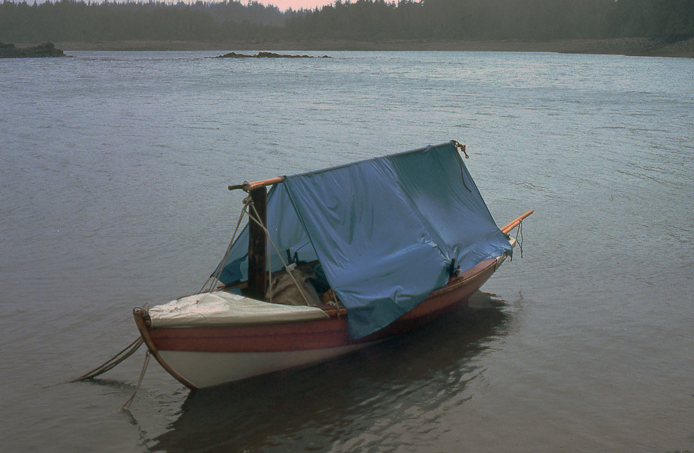
It was only 10:00 a.m., but I was certainly done for the day. The tide was nearing low slack. I left GAMINE where I’d come ashore and let the water slip out from under her. I dropped the rig, set up the boom tent, and heated a bowl of soup for an early lunch.
My accommodations were spartan at best. I slept on the floorboards with my legs tucked alongside the centerboard trunk. To roll over, I had to pull my legs back, lift them over the thwart, and tuck them on the other side of the trunk. All that required waking up. Here in Kelp Passage, the tide is rising as my last night of the voyage approaches.
I spent most of the day aboard the boat, and once she was afloat, she kited back and forth at the end of the anchor rode. The wind was blowing unabated and howling in the trees surrounding the cove. Tide would rise more than 20′ from the low and would lift me out of the lee, so in the afternoon I rowed deeper into the passage and anchored in larger cove better sheltered from the wind.
I spent the rest of the day aboard the boat tidying up, eating, and resting. At dusk, as I was settling in for night, the falling tide set GAMINE gently on a muddy plain. Grounded, I’d sleep well and be afloat in the morning. I awoke just before midnight and looked out from under the boom tent. The gibbous moon, just four days past full, was illuminating the landscape; as far as I could see, there was no water anywhere in the passage.
To the south, the islands were being swallowed up by fog.
When I woke, GAMINE was afloat and the air was still. I packed up and left in a hurry, not wanting to waste good rowing weather. As I headed north, Kelp Passage broadened and became Chismore Passage. Clear of Chismore’s north end, I set a course across Arthur Passage toward Smith Island, 4 miles away to the northeast. To the south, islands were turning pale and then disappearing as they were being enveloped by an approaching fog bank.
The horizon had disappeared behind a chalky haze, and when two pilot whales rose in tandem, their hooked black dorsals were the only marks on a dimensionless amalgam of sea and sky.
GAMINE’s bow is aimed at Alaska, hidden in distant fog bank beyond the gap between the northernmost islands of British Columbia. It would remain out of reach.
I rowed hard as fog wrapped around the south end of Smith Island and veered north by degrees, completing the crossing just before losing sight of the island. I crossed to Lelu Island and found my way along its western shore blocked by a sandbar that had been uncovered by the low tide. The bar stretched all the way to Kitson Island, a full mile to the southwest.
Prince Rupert is a busy port and I didn’t know where I’d be able to come ashore. In the midst of all of the oversized commercial facilities, I found the Prince Rupert Rowing and Yacht Club. I was welcomed there and allowed to stay for several days while I made arrangements to take GAMINE back home.
After I rounded Kitson, the fog cleared, and to the north I could see the last of the islands on the British Columbia coast stretched out along the horizon; beyond them lay Alaska. As close as I’d come to it, the weather had made it clear that it was time to stop. As I made my way to the port city of Prince Rupert, the sun broke through a ceiling of clouds the color of tarnished silver. I rowed the last 7 miles bathed in sunlight.
Epilogue
Wanting it to be over
I took this picture of myself during a break from rowing Grenville Channel. Thinking that I’d look back on this experience in a few years with fondness, I wanted to have something to remind me how difficult it was and how often I was either wet, cold, tired, hungry or all four.
After 31 days, having travelled over 700 miles aboard GAMINE and almost 100 miles with RAINBOW, I was relieved to be in Prince Rupert and on my way home. I hitched a ride back to Seattle; GAMINE came along on top of the van. I never did another cruise aboard her and eventually sold her.
I spent several days in Prince Rupert waiting for a ride back home to Seattle. No longer burdened by cruising, GAMINE and I both felt a bit lighter.
For a while I gave up on cruising, but when I saw maps of other inland waterways, the same stirring that had compelled me to build and sail GAMINE came over me. Between 1982 and 1987 I built three more boats for three more inland cruises. The first of those cruises was longer—2,500 miles over the course of 4 ½ months— and the one that followed was more challenging—2,400 miles in 2-1/2 months in the middle of winter. Eventually I returned to the Inside Passage and made it to Alaska.
During all those cruises I never came up with a good answer to the question—”Why?”— posed to me by young Bergie while I was aboard GAMINE in Nanaimo. I had no goal, at least not one that I could find within me, let alone express. To be sure, I had many memorable experiences, but they took on meaning only in retrospect and even the sum of them couldn’t account for whatever it was the kept me coming back to travel by boat. If I had known what I was looking for, I might have taken the quickest path to it and, having achieved it, set out for something else. When I was looking at maps of the British Columbia coast I must have seen the convoluted course of the Inside Passage not merely as a waterway leading north, but as a path I could follow to explore what I was capable of and perhaps discover something about myself.
Christopher Cunningham is the editor of Small Boats Monthly.
If you have an interesting story to tell about your adventures with a small boat, please email us a brief outline and a few photos.
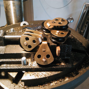
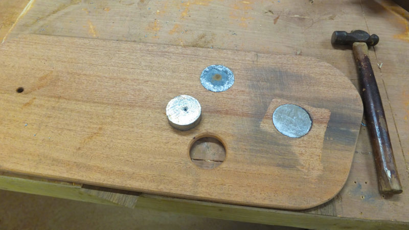
When Kyle and I decided to build our own boat to take on a trip down the Mississippi River, we decided to make, rather than buy, as many of the bits and pieces as possible to save money and make the build and journey on the boat even more meaningful. We needed five blocks for SØLVI’s sailing rig and looked to see what was available on the market. Traditional bronze blocks were beautiful but heavy and expensive. High-tech blocks for dinghy racing, made of stainless steel and fiber-reinforced plastic, were light and smooth-running, but expensive and not in keeping with the classic look we wanted. Our research led us to L. Francis Herreshoff’s Common Sense of Yacht Design, where we found drawings of blocks that we could adapt to meet our requirements.
While Herreshoff called for cast bronze sheaves, we decided to buy Harken’s Delrin ball-bearing sheaves. They are strong, smooth-running, and affordable. We ordered six—one for a prototype and spare—sized for 3/8″ line. The sheaves cost $10.99 apiece (less expensive sheaves, without ball bearings, are available in nylon or bronze from Duckworks). We purchased a 12″ x 12″ sheet of 0.062″ naval brass (C464) for $54 (and needed only half of it; a high silicon-bronze—C655—would also work), 36” of 1/4” bronze rod for $18, and a package of 100 bronze cotter pins for $5.
Danielle Kreusch
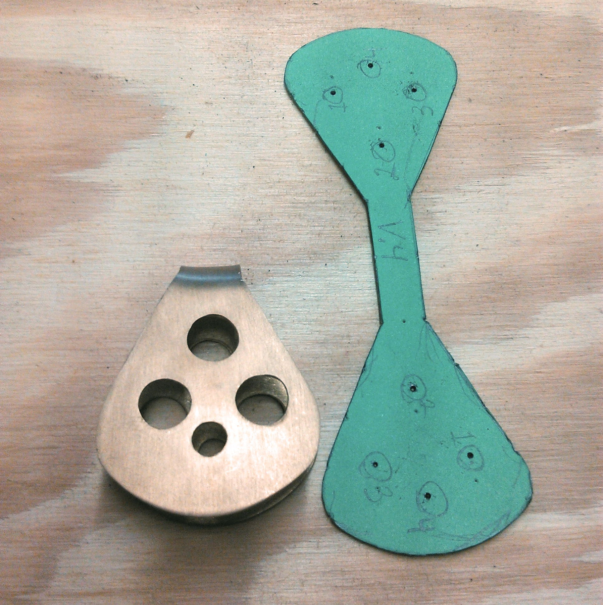
The paper pattern has small holes to locate the position of the holes to be drilled in the cheek plate. The straight portion of the pattern needs to be long enough to assure there will be enough clearance for the line.
Herreshoff made his blocks with two flat cheek plates joined to a third piece of bronze; we’d make both plates in one piece, bent to fit around the sheaves. The bend would have to provide enough clearance for the 3/8″ line to run freely. Rather than use the expensive bronze to get the right dimensions for creating a pattern, we used a piece of 1/16″ aluminum flat-bar to determine the distance needed between bend and the sheave axle. Our bending jig for the flat-bar, as well as for the plates we’d bend later, was a scrap of oak a bit over 1/2″ in thickness to match the sheave and with one end a half-round.
The bronze will spring back after it has been shaped to the jig and must be finished by hand. The fit isn’t critical as it would be with a simple, non-ball-bearing sheave. With the Harken sheave the cheek plates can be squeezed tight against its round inner circle; the outer ring will still spin freely.
After making a pattern on stiff paper, we went to work on the cheek plates, tracing the pattern in fine-point marker and cutting the line carefully. Cutting bronze sheet with a jig saw requires some care to keep the blade from binding in the tight turns and deforming the metal; any damage was easily fixed with a hammer. We then made the four holes in each cheek with a cordless drill; three 3/8″ holes were to make blocks lighter and more aesthetically pleasing, one 1/4″ hole was for the sheave axle. This prototype proved perfectly serviceable, and we went to work on the rest.
Danielle Kreusch
Homemade blocks met our goals for weight, affordability, and a classic look. The two blocks at the left share a single axle, creating a double block.
We decided that spending $14 on a new metal-cutting blade for our bandsaw was a good investment in the project; while not a necessity, it was more efficient than using the jigsaw. We smoothed the edges of the bronze sheet with a disc sander, something that could also be accomplished with files. After bending the cheek plates on the jig, we installed the sheaves with 1/4″ naval bronze rod axles, held in place with cotter pins on the ends.
We had intended to use bronze shackles with the blocks, as Herreshoff did, but decided they would add unnecessary weight and expense. We ended up splicing loops of line to the blocks or lashing them in place.
Our blocks were just half the cost of cast bronze blocks, and were not only lighter but also smoother rolling. After over 1,000 miles of sailing and use, we found the blocks to be durable and attractive.
Danielle Kreusch grew up in Salt Lake City, Utah and spent a lot of time hiking and camping in the mountains. After moving to Florida to finish her BA in Psychology and Child Development, Danielle met Kyle Hawkins, who took her sailing on their third date. Their Mississippi River trip was their first small-boat excursion, and they have both fallen in love with the idea of continuing to travel in small boats.
You can share your tips and tricks of the trade with other Small Boats Monthly readers by sending us an email.
The east side of the Bustard Islands was all shoals and breakers, with a broad band of granite shelves and outcroppings stretching half a mile or more offshore. Typical for Georgian Bay, I knew, where the safest routes run well outside to avoid the rocks, or follow the well-buoyed passages of the charted small-craft route that traverses Georgian Bay’s eastern shoreline.
Here in the Thirty Thousand Islands region, only kayaks and canoes—or a sail-and-oar cruiser with her board and rudder up—can manage to sneak through to the shore in most places. And even boats like my as-yet-unnamed Don Kurylko–designed Alaska beach cruiser have to pick their way carefully. Passing through the northern end of the Bustard Islands on my approach from the west, I had seen a few cottages and sailed past half a dozen larger boats in the main anchorage between Tie Island and Strawberry Island. Out here on the east side of the Bustards I was completely on my own.
photographs by the author
Like most of Georgian Bay’s eastern shore, the Bustard Islands are a compact collection of long narrow channels running parallel to each other, divided by low ridges of the Canadian Shield’s exposed granite topped by mature white pines. After I made it through the wide band of rocky shoals offshore, I threaded my way into Tanvat Island’s east side.
Holding a close reach well offshore, I eased the sheet until we were barely moving, fore-reaching along at half a knot. From a mile away it was almost impossible to identify any features of the low-lying islands behind the band of shoals, but I made my best guess at identifying an inlet that might mark the channel I wanted and took a bearing with my hand compass. Things would become clearer as I got closer, but I wanted to have at least some idea where I was headed before starting in.
Roger Siebert
.
On the chart, Tanvat Island is a spiderweb of long-fingered inlets and peninsulas reaching out to the north, south, and east; long ridges of pine and granite surrounded by hundreds of smaller islands that made it difficult to recognize the underlying shape. It looked like I should be able to skirt along the northern edge of the shoals and work close to shore in mostly open water. Worth a try, at least. I sheeted in to gather speed and pushed the tiller over to put the boat on a port tack, then steered toward the east side of Tanvat Island, watching the compass closely. I was trying for a course just south of west, but soon I was detouring around slabs of granite lying just beneath the surface and dodging half-submerged rocks almost completely hidden in the waves. After a few minutes, I gave up. “Mostly open water” or not, it would be foolish to try to sneak in any closer under sail. Turning into the wind, I dropped the sail and unclipped the halyard. It would be oars from here.
I pulled up the centerboard and rudder and slid the oars into the locks, then glanced again at the chart as we drifted slowly toward shore. I had managed to judge my entry well, despite my somewhat rough combination of eyeball navigation and compass bearings. At least, I thought I had judged well. But the chart might as well have been an inkblot test, a convoluted scrawling of rocks, islands, and narrow channels that twisted around each other like snakes crawling through a maze. When I put the tip of my finger down about where I thought I was, it covered more than a dozen islands. I wasn’t about to put any money on which one was which.
It didn’t really matter, anyway. I was almost through the reefs and safe along the east side of Tanvat Island—if I could manage to figure out which one it was. The narrow passage opening before me was lined with tall pines and granite slabs, and surrounded by a chaotic jumble of rocks, islands, hidden bays, and gnarled peninsulas. Was this the channel I had hoped to hit? I’d find out soon enough. Either way, I had reached the Bustards. It had taken me four days and a hundred miles, but finally, I was here. I moved to the aft thwart so I could row while facing forward—an advantage in avoiding the countless uncharted rocks and shoals I knew I’d encounter here—and made my way slowly deeper into the maze.
I had launched in the center of the North Channel, at the municipal marina in the small town of Spanish, Ontario, a ten-hour drive from home. Another four or five hours in the car would have gotten me to Georgian Bay two days sooner, but from my previous visits I knew Spanish had what I needed: a good ramp, showers, a laundromat, and, most important of all, hassle-free parking for a car and trailer for weeks at a time. Although I wanted as much time in Georgian Bay as I could get, that alone made Spanish a worthwhile trade-off.
After spending the first night on East Rous Island I woke to the flat calm of a typical North Channel summer morning. Three hours later, after rowing 6 miles and stopping briefly in the town of Little Current, a slight breeze arrived and I could stow the oars and raise the sail.
I had covered 60 miles in the first two days, broad-reaching on the starboard tack for hours on end, bypassing towns and marinas and overnighting in out-of-the-way backwaters, places too shallow or too small to see much traffic. At East Rous Island, a few miles west of Little Current, I anchored in knee-deep water outside the crowded main anchorage and slept on the Alaska’s full-width sleeping platform; at Thebo Cove a mile outside Killarney, I tied to shore and set up a freestanding tent on a granite slab.
This rocky beach on the west side of West Fox Island, 7 miles east of Killarney, offers a convenient place to land a boat, but lies completely exposed to the prevailing westerlies. Overnighting here is best left to kayaks and canoes—lightweight boats that can be carried up the beach. I had lunch here and headed north to spend the night in better protected waters.
The third day had brought me 7 miles east of Killarney to the Fox Islands, a favorite destination from earlier trips. Here, finally, was Georgian Bay, wild and rocky and filled with possibilities: high granite domes rising from the water, broad smooth slabs of Canadian shield granite sweeping up to jagged skylines of tall pines, trees that have withstood the prevailing westerlies for so long that they remain forever bent and twisted toward the east as if reaching out in supplication to some unseen power. After a lunch ashore on West Fox, I set out again, ghosting along in winds so light that I could barely feel the breeze.
A mile north of West Fox Island, the cluster of islets around Anchor Island and Solomons Island offers dozens of protected campsites for small boats. With an open boat, sleeping aboard is a good option only if you have foolproof mosquito netting. I opted to spend the nights in my tent.
Well, so be it. I’ve learned to enjoy what the day gives you rather than worrying about what it does not. This would be no 30-mile day. Instead, I worked my way slowly northward toward a cluster of islands only a mile away. With the wind behind me, and rocks all around, I sailed carefully, centerboard up, through cliff-lined channels less than a boat-length wide, sneaking through passages barely deep enough for my boat’s 7″ draft. And there, in a tiny shoal-draft backwater tucked in between Anchor Island and Solomons Island, I tied the boat to shore and unloaded my gear. This would be camp for the night. An afternoon ashore, scrambling among the rocks and climbing to the island’s tall summit, a long swim in the pleasantly cool water, and a quiet night at camp. After two days in the boat, it was exactly what I needed.
But now, 30 miles farther on and ready to make my landfall in the Bustards, I needed to figure out where I was. With no GPS—I try to avoid machines that purport to do our thinking for us—that might not be easy. But I knew it was almost always possible, even in a complicated setting like this. Here. The channel I was following split into two branches, then split again. I looked closely at the chart, turned it to align with the compass. A cluster of rocky islands here, a lone rock there. This was it—I had managed to find the passage I had been looking for. All I had to do now was follow the channel’s right-hand shore—Tanvat Island, I was fairly sure—through every twist and turn, as if working my way through a labyrinth with one hand on the wall. I kept rowing. A few more rocks and islands that matched the chart precisely confirmed it. Amazingly enough, I knew exactly where I was.
My fourth day began with cold rain and a strong breeze. Fortunately, the boat’s boomless standing lugsail is easily reefed: simply roll up the foot and tie it in place. With the first or second reef tied in, the boat performs well to windward; the deep third reef keeps things in control when running for shelter.
Twenty minutes later, rowing along a long narrow bay that ran between two ridges of granite topped with dark pines, I found my campsite: a broad smooth slab of gray stone that swept up from the water to a stand of gnarled pines above. Behind the trees, the ridge dropped down again to a dark pond dotted with white-flowered lily pads. The water here, so deep inside the maze, was perfectly calm with only the slight wake from our passage rippling through the reflection of the rock and sky and trees. I shipped the oars 10 yards out and let the boat glide slowly into shore, then stepped out into knee-deep water and tied the painter to a beaver-chewed stump at the water’s edge.
It had been another long day—30 miles of non-stop sailing on a close reach, and a half-hour of rowing. There was plenty of daylight left, but I felt no need to go farther. Instead, I stood barefoot on the stone and felt the rough texture of the granite, the curling lichen underfoot. Breathing deeply, I listened to the world around me. It was not silence, not completely, but a quiet stillness that seemed to hang heavy in the air. A whisper of shifting branches overhead, the faint ripple of water. And somewhere, a moment later, the call of a loon. I unstrapped my dry bags from the boat and carried them to shore.
I woke the next morning to a world blurred by gray mist and shrouded in silence. The water was still and dark at the foot of the rocks, a liquid mirror unruffled by the faintest hint of motion. Far out at the eastern edge of the islands, fog lay so thick on Georgian Bay that there was no horizon, no up, no down. It was no day for offshore sailing, but it would be perfect for exploring the maze of backwaters, narrow passages, hidden coves, and islands that made up the east side of the Bustards.
Moving as quietly as I could, I got my raincoat and water bottle and set them in the boat, then untied from shore. I stepped aboard with a gentle push, easing myself onto on the rowing thwart as the boat slid away from shore. As I lowered the oars gently into the water, I realized that I hadn’t even bothered with breakfast.
The fog held through the morning, painting the world in a palette of muted grays and blacks all around me as I rowed. A hundred oar strokes, a hundred paintings. The foreground of each scene came into sharp focus as I moved through it, the background forever hazy and indistinct. A vague darkness of pines; an oddly serrated slab of rock revealed itself to be a line of gulls standing and muttering to themselves as I rowed closer. From overhead came the rattling cry of a sandhill crane.
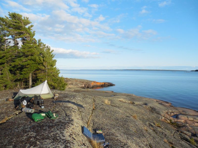
Hidden in the complex web of Tanvat Island’s surrounding maze is a wealth of potential campsites and anchorages. This perfectly sheltered inlet, my base camp for two nights, was tucked well back inside the Bustards, more than a half mile from the open waters of Georgian Bay.
My 18′ Alaska had been designed with exactly this in mind. With its Whitehall lines and narrow double-ended waterline, it was a decent sailer, but a flawless pulling boat. Built of 1/2″ planks, edge-nailed and glued—traditional strip planking—she was heavy enough to hold the momentum of each stroke. The oar blades dropped silently into the water, again and again, and glided through the maze with little effort and even less noise. At times the channel I was following pinched down to a passage so narrow there was no room to row, but the Alaska glided through easily, the hull’s weight preserving forward motion while the long keel kept her straight.
The layout of the maze become clearer in my head as I explored, my perceptions shifting to bring the chart and the world around me in line with each other. I had camped in the center of a long irregular peninsula that stuck out from the east side of Tanvat Island like a pair of weirdly twisted, frog-like legs. North of the peninsula was a large bay filled with so many islands that it was hard to recognize that it was, in fact, a large bay. By lunchtime I had explored it thoroughly under oars, making the discovery that the “peninsula” I had camped on was, in fact, an island—water levels were so high that a small circular inlet just west of camp had become a passage through to the other side. At least, a passage for boats with extreme shoal draft. Even the Alaska managed to scrape her keel as I slipped past.
A foggy morning on Tanvat Island’s east side inspired a lengthy rowing expedition before breakfast. On the chart, this bay was a dead end, but high water levels on Lake Huron and Georgian Bay allowed me to row all the way through and out the other side.
I returned to camp for lunch, a meal of red beans and rice I had prepped in my Thermos the night before. After eating, I set out again, this time following the southern edge of the peninsula. The day was still hazy and windless, the water flat and dark. I followed the shoreline of the peninsula until I reached its base, where I rowed far back into a fish-hook bay filled with lily pads, the shores strewn with beaver-gnawed branches. I had rowed 2 miles to get here, but the hook of the bay was dug so deeply into the island that a ridge of granite a few yards wide was all that separated me from the north side where I had spent the morning exploring. I had rowed for several hours and was barely a quarter of a mile from my campsite.
The Bustards, I realized, were a world of infinite possibilities.
Two hours after leaving camp, rowing steadily all the while along a circuitous route, I was still less than a mile from camp as the crow flies. The Bustard Islands hold more possibilities per mile than any other cruising area I’ve experienced.
One of the great joys of traveling by one’s self, I’ve learned, is that much of the need to plan ahead is negated. The solo traveler—the solo sailor—is free to act on a whim, and can keep all options open. By the time I had eaten a quick bowl of oatmeal the next morning, I still had no idea how I would spend the day. I suppose that many people would find that level of uncertainty unsettling, or annoying. Perhaps even foolish. I find it liberating.
I loaded everything into the boat—tent and gear, food and sailing rig—to keep my options open. First I’d row out to the mouth of the bay, where I could get a look at conditions on Georgian Bay proper. If the wind was good to continue south and east along the coast, I’d be ready to sail. If not—
Well, if not, I’d find something else to do. Just to be on the safe side, I surveyed the crew about my plan’s lack of specificity. No one objected. Taking a last look around camp to make sure I hadn’t forgotten anything, I rowed slowly out the channel toward the open water beyond. After ten strokes, the granite slab where I had set up my tent had vanished into the mist.
My technique for rowing the channels in the Bustard Islands was to keep the boat running straight with the help of a bungee-and-cord tiller tender and go fast enough to coast through the narrow spots.
As soon as I reached the edge of the bay, I knew that I wouldn’t be heading offshore. Fog had settled so thickly on the open waters of Georgian Bay that I doubted I’d be able to see the faintest hint of the Bustards from a hundred yards offshore. A chart and compass would suffice to get me to the next landfall, I knew—the ominously named Dead Island 3 miles to the east, where First Nations tribes had long ago interred their dead in the treetops, according to some sources I’d read—but it wouldn’t be the height of good judgment.
Besides, I was far from done here. On my only previous trip here, I had only stayed one night. This time I wanted more. But more what? I had already explored most of the eastern side of Tanvat Island, and retracing yesterday’s paths seemed less interesting than trying something new. I pulled out the chart. Tanvat Island, the largest in the Bustards, lay spread out across the page in two monstrous, squid-like lobes separated by a narrow isthmus where a deep bay cut into the shore on the western side. The area around Burnt Island just to the west housed a number of cottages, and the Bustard Island Headquarters for French River Provincial Park. There’d be other boats, other people. Burnt Island was, in other words, better to avoid.
The pond behind my Tanvat Island campsite—you can see my yellow tent through the fog—was too shallow for the boat’s 7” draft, and the entrance too narrow for the hull. It was a rare dead end.
But Tanvat Island itself? Possibilities. Tracing my finger around its convoluted outline, I wondered about a circumnavigation. But Tanvat’s northern end was pinched so tightly together with Strawberry Island that their outlines on the chart were touching. And Tanvat’s southern end was an endless scattering of rocks and shoals. Then too, there was a wide band of blue—the color used to indicate depths too shallow to bother marking—surrounding the entire island. I knew from yesterday’s explorations that not even my Alaska could always float across that blue band, and at 250 lbs for the empty hull, I wasn’t going to portage her. With water levels as high as they were, I thought my chances were good, but there would be no guarantees.
Gripping the oars lightly, I turned the boat north along the east side of Tanvat Island to begin—a counterclockwise circumnavigation. Or an ignominious failure. Either way, it’d be a good day.
The interior waterways of the Bustard Islands seem far removed from the open waters and offshore passages of Georgian Bay, but a good sail-and-oar cruising boat is equally at home in either world.
By late afternoon I had returned to the east side of Tanvat Island and pulled into the wide bay just south of my previous campsite, circumnavigation complete. I had seen no one. No one, that is, except for a few beavers, a pine marten (the first I’d ever seen in the wild), a northern water snake, a blue heron, a curious mink who swam out to the boat to stare wide-eyed at me for a moment before vanishing underwater, and an eastern massasauga rattlesnake that sidewinded its way across the surface of the water and crawled up onto the rocky dome where I had stopped for lunch.
The best thing about a long cruise is that there’s never any reason to hurry. With the fog gone, I enjoyed a quiet evening in camp after my all-day circumnavigation of Tanvat Island.
In the center of the bay I made camp at a cluster of three islands—in my head I had taken to calling them the Three Brothers—and rigged lines to keep the boat in shallow water without banging against the rocks. After a long swim and another Thermos-cooked supper, followed by a second course of instant mashed potatoes, I set up my tent on the island’s eastern summit, a bare granite dome overlooking the bay from ten feet above.
On my last night in the Bustards, I chose a tent site that faced east over relatively open water. As a result, the morning light woke me well before the sun cleared the horizon.
The sun was setting behind me, and the sky filled slowly with pinks and blues and wisps of purple clouds. The reflection in the still waters below was no less vivid. A sandhill crane flew past, wide wings flapping silently. Its rattling call was answered by another from deep within the dark pines of Tanvat Island. And then, silence.
Looking east from camp on my final morning in the Bustard Islands, it was easy to see a clear route out to the open waters of Georgian Bay to continue my journey.
I stood for a long time watching the sky grow slowly darker, until the first stars began to appear overhead. Tomorrow would be a fine sailing day and in the morning I’d be heading south along the shores of the Thirty Thousand Islands, sailing deeper into Georgian Bay. Being fogged in among the Bastards had seemed like an interruption at first, but the delay had forced upon me a mist-muted world where time and distance had become irrelevant, ambiguous, uncertain. For three days I had moved through a veiled, endless now, where each stroke of the oars only held me more firmly in place in the moment. Whatever lay beyond the mist remained out of reach no matter how far I rowed. When I woke the next morning to blue skies and bright sunlight, the Bustards felt like another world entirely, one made finite by its startling clarity.
Tom Pamperin is a freelance writer who lives in northwestern Wisconsin. He spends his summers cruising small boats throughout Wisconsin, the North Channel, and along the Texas coast. He is a frequent contributor to Small Boats Monthly and WoodenBoat.
If you have an interesting story to tell about your adventures with a small boat, please email us a brief outline and a few photos.
The French term voile-aviron translates to “sail and oar,” and describes a type of small cruising boats with a devoted following. French naval architect François Vivier has created an extensive portfolio of voile-aviron boats, and the Ilur is his most popular—many hundreds of them sail in France and a growing number are being built in North America. With a quiet, robust beauty, the Ilur’s current iteration represents an impressive marriage of classic form, 21st-century computer-assisted design, and modern plywood-and-epoxy glued lapstrake construction.
The Ilur arrives on pallets as a precut kit with CNC-cut components, including a strongback on which the hull is built. One of the key aspects of the kit-built method is the use of sawn bulkheads and interlocking longitudinal stringers that, as Vivier brilliantly executes, form both the building jig and the majority of the internal furnishings, so that after the hull is planked and flipped, much of the interior has already been completed. The result is an extremely strong hull that can be accurately and quickly executed by professionals and amateurs. The bulkheads and frames are 3/4″ marine ply, the planks are 3/8″.
John Hartmann
There are two rowing stations on the Ilur. The author made the aft station’s thwart removable to open up the cockpit for sleeping aboard, and he now usually sails without it.
With 10 strakes per side, there are a lot of rolling bevels to cut at the laps, and gains at bow and stern, but the work is pleasant, and not difficult. The builder will need to source lumber for the keel and keelson, floorboards, benches, thwarts, and spars. The plans are extremely detailed, and Vivier is quick to respond personally to emailed questions. Instructions are included for construction of rowing and sculling oars, and for hollow, four-sided spars. Vivier suggests about 400 hours to assemble the CNC kit; I took me almost twice that long, but the extra time went into items not covered in the plans, such as constructing hollow bird’s-mouth spars and casting a bronze mast partner.
The finished boat looks like a classic, traditional lapstrake boat. It also has ample storage with room below the cockpit sole for two pairs of 9-1/2′ oars, an anchor locker ahead of the forward thwart, and a large lazarette at the stern. For a boat less than 15′ long, it feels like a much larger boat. The hull shape is quite full, and the bilges are firm. As a result, the Ilur is very stable—I can stand or sit on the gunwale, and there are still three strakes of freeboard above the water.
John Hartmann
The mizzen and boomkin are set to port to keep clear of the tiller. This boomkin is hollow, allowing the mizzen sheet to run through it. The arrangement helps keep the stern a little less busy and prevents the sheet from fouling on the tip of the boomkin when coming about.
Under sail, the firm bilges show their worth in a wide range of conditions. As the breeze freshens, the boat will heel until the turn of the bilge buries, and the boat stiffens up and accelerates under its ample press of sail. In ghosting conditions, I sit to leeward, and the boat offers a sweet spot with minimal wetted surface area, while the full, curvaceous midsection of the hull maximizes waterline length for potential speed.
Though the Ilur’s measured waterline length is just over 13′, it is sneakily fast, and will happily sail in company with much longer boats such as Oughtred double-enders or Sea Pearls without struggling to keep up. In all conditions, the boat communicates clearly, gently, and progressively—there is simply nothing twitchy about her. Vivier designed the boat with built-in flotation in compliance with EU regulations, and it can be righted singlehandedly in self-rescue situations. Once upright, the water level inside the boat is below the top of the centerboard case, further improving the odds of a complete recovery.
John Hartmann
This Ilur carries the boomless Misainier rig. The lugsail, reefed here, has an area of 131 sq ft.
There are four rigs available, including a large, boomless standing lug, a balanced lug, a lug sloop, and most recently, a lug yawl, the rig that I had asked Vivier to create for the Ilur I built. The boat is well balanced under sail in all those configurations, and the weather helm is mild. It is surprisingly close-winded, and tacks through 90 degrees.
The full forward sections and generous freeboard provide a pretty dry interior when conditions are choppy, and any spray coming aboard drains to the bilges, so the crew is high and dry on the cockpit sole. In light wind, my favorite place to sit is on the sole, with my feet up on the leeward bench. My weight is low, the sail is well overhead, and the view over the gunwale is unobstructed. It is a delightful and cozy place. Likewise for the crew, a seat on the sole allows the gentle curve of the hull to form a very comfortable backrest, and the boat is roomy and secure.
The helm takes just a finger on the tiller, and often, using the mizzen to balance the helm, the Ilur can be trimmed to self-steer. As the winds strengthen, I sit up on the bench. Hiking out is rarely required. By the time whitecaps are widespread and the winds are in the 12–15 mph range, it is time to tuck in a reef. With the yawl rig, this couldn’t be simpler: turn the boat head to wind, sheet the mizzen in tight, and drop the tiller. The boat stays calmly hove-to, with the mainsail quietly at rest over the centerline of the boat. I walk forward and lower the sail while the boat tends itself. I move the tack downhaul up to the first reefpoint on the luff, then I move to the clew end of the sail. The mainsheet is reattached at the new reefpoint, and the sail is rolled into a neat bunt as I tie in the reef nettles while working my way forward. Back at the bow, I raise the main, then move aft to retighten the tack downhaul. After I release the mizzen sheet I can fall off onto my new heading. The whole process takes two or three minutes, and can be handled solo without any drama, even when conditions are boisterous.
The Ilur has stations for two rowers, but the glued-lap construction makes the boat light and easy to propel rowing solo in calm conditions. Even when the boat is loaded with a week’s food and dunnage, I can maintain 2-1/2 to 3 mph at an all-day pace. I drop the spars to reduce windage. The sail, yard, and mizzen fit inside the boat; the mainmast is taller than the boat is long, and is stowed with several feet overhanging the transom. The plans describe arrangements for fitting a small outboard to one side of the rudder. A long shaft is preferable, so no transom cut out is needed, just protection on both inner and outer faces of the transom for protection from the outboard’s clamps. I have not felt the urge to equip my Ilur for power, given how easily it is driven by sail or “ash breeze.”
Gabrielle Hartmann
The lug yawl rig carries 134 sq ft of sail. The sprit boom on the main was suggested by the sailmaker, Stuart Hopkins of Dabbler Sails. With its forward end set high it is self-vanging, a useful attribute when running downwind.
Ilur owners who cruise with their boats can sleep aboard under the shelter of a boom tent. The CNC kit boat’s full-width sawn frames are rigid enough without being braced by a thwart, so the rear thwart can be fitted to lift out of the way, creating a tremendous open area for spreading out bedrolls. Here again, keeping the weight low in the boat pays benefits. The Ilur, like many boats designed for oar and sail, is designed with a relatively narrow waterline beam to improve its rowing qualities, and if the sleeping platform were at thwart height, the boat would feels “tiddly.” With the floorboards at the waterline, the Ilur is anything but tiddly with the crew sleeping there, and a restful night’s sleep awaits.
On a recent overnight outing on Lake Champlain, I anchored in a protected bay after a fine day of sailing. I watched an osprey catch its dinner a few yards from my anchored Ilur, and as evening fell, I was surrounded by a flock of several hundred Canada geese that shared my mooring area for the night. In the morning, as I was readying the boat and storing gear, and was investigated by a family of four otters that swam up to check me out at close quarters. Experiences like these are what I love about voile-aviron boats—they get you to beautiful places slowly and quietly enough that you join the neighborhood of wildlife without scaring it off. The Ilur is perfect for the task—capable, commodious, and comfortable.
John Hartmann lives in central Vermont. He built his Ilur, WAXWING, to sail the 1000 Islands region of the St. Lawrence River, Lake Champlain, and along the coast of Maine. You can see his Ilur flying a mizzen staysail in “Mizzen Staysails Add Power” in our August 2017 issue.
It was the spring of 1988, the year I turned seven, and Dad was restless. Mom was happy on our little homestead. Dad had built a log cabin for us on the hill at the north end of the family property, as well as a blacksmith shop, a sawmill, a henhouse, goat barn, horse barn, picket-fenced garden, and other accoutrements of the homesteader, but he was growing bored with farm life.
photographs courtesy of the Blake family
From the cypress logs to the stone chimney, Dad built every inch of the cabin where I spent my childhood. Mom’s baskets are piled on the front porch and my pet deer is visible next to them. The baskets went to the fair for sale, the deer did not.
The goats were in milk, the front porch was stacked with baskets Mom had made for the county fair, and she was happily painting in her studio when Dad announced that he was going to build another boat. His last boat, a Block Island double-ender, was christened MERRY SAVAGE, a play on his great-grandmother’s maiden name, Mary Savage. Dad had sailed that boat along the coast of the Gulf of Mexico for a few months, and then she languished around the house for a few more before being sold to a young man from Maine. This all seemed a trifle foolish to Mom, so when Dad said “I am going to build another boat,” she responded, “We will have to actually use this next one, and it should be for the whole family.” She would regret that statement several times over the next few years.
The old Model-A John Deere tractor was parked next to the mill to power the big circular saw. My dad and uncle must have been taking a break for lunch, otherwise and the sawmill would be running and one of them would be riding on the carriage.
Dad thought about the design for a few months, made a few half models, sat down at the drafting table, and the idea for a new boat was born. Based loosely on a Portuguese 16th-century caravela redonda but cutter rigged, the MARY SAVAGE would have an overall length of 31′, a beam of 8′, and a draft of 32″. The name, at my mom’s request, was the proper spelling for my great-great-grandmother’s name. We started by calling the boat the MARY SAVAGE II, but eventually we just referred to her as the MARY SAVAGE. Dad was hoping we’d sail down the Mississippi River, take the Intracoastal Waterway to the East Coast, and then decide whether to head for Maine or the Caribbean. I don’t think Mom took him seriously.
When I wasn’t in school, I’d often help Dad with the boatbuilding. He taught me how to drive cotton roving in a seam and how to buck rivets.
Soon Dad and the old Model-A tractor were out in the woods, felling timber for the new boat. He selected black locust for the timbers and the planking to the waterline, sassafras for work above the waterline, and walnut for trim. After the logs were skidded from the woods, the tractor was flat-belted to Dad’s sawmill and he and my uncle cut, stickered, and stacked the lumber for the boat.
The planking up to the faintly visible red line was black locust; above it was sassafras. I imagine even if the MARY SAVAGE were ever left abandoned to rot away, the lower hull would still hold together.
Dad built the MARY SAVAGE outside, so every night she would be covered in blue tarps and every day she would be uncovered and the work continued. As the boat came together we had many visitors; people came from all over to see the eccentric folks who were building a boat near the goat house in the little cabin on the hill. Some were encouraging, and some simply shook their heads in disbelief.
Before the boat was finished, I spent many afternoons on board, sailing imaginary seas. The fo’c’s’le would be my quarters when we eventually got underway. There was one port that faced the after cabin and a clear panel in the hatch to let light in.
For several years it seemed as if nothing would actually happen. Life went on as usual; Dad worked on the boat, Mom continued to make baskets, weave, spin, sew, and paint, and I went to school. Then in the spring of my 10th year, the paint was on, the crowd was gathered, including our Episcopalian priest, and the boat made its way to the bank of the Yazoo River for launching, blessing, and party. A bottle of champagne was smashed on the bow, the priest blessed MARY SAVAGE stem to stern, and into the river she went.
MARY SAVAGE is ready to be taken to the river to meet the water for the first time. I am aboard to give advice and stay out of the way.
There were weeks of work to do after launching, but my world had changed. We were renting our house, I was leaving school, the animals were sold, and the goodbyes began. Despite assuring my fourth-grade class that I would return by fifth grade with a suitcase of gold (I was reading Treasure Island), I began to worry. If I was worried, Mom was a wreck. She had not expected Dad to complete a boat big enough for the family in such a short period of time. I think, in a way, she hoped the project might take forever.
At the Vicksburg waterfront we were preparing for our voyage. I stand in HAPPY COCKROACH, the ship’s boat, ready to ferry friends and family.
We took up residence on the boat at the Vicksburg waterfront while Dad made final preparations. We had many visitors, and I ran the official ferry in the ship’s boat—a little 7′ scow stowed on the after cabin roof when it was not being towed behind. Mom called it “BRAIN OF POOH” as a reference to A.A. Milne and perhaps a slight dig at the builder (Dad), but, as she was my boat, her real name was HAPPY COCKROACH. As a ferryman I only lost one passenger, but it was not really my fault. He was a rather large man and unsuited for such a small boat. He managed to swim ashore bedraggled, but otherwise unharmed.
With the final preparations made, I put on the best bold, able-seaman pose that I could manage.
The day finally arrived for us to leave the Vicksburg waterfront. It was mid-April 1991. There was a huge party. It seemed as if the whole town had come to see us off. Goodbyes said, we boarded the MARY SAVAGE; Dad went below and spun the flywheel on the one-cylinder Volvo diesel. We set out southbound. The bridge at Vicksburg, spanning over a mile, seemed to rise up forever as we passed underneath. I said, “Look Mom, a gateway to another world!”
The Mississippi river stretches before us. Our old life lies behind and adventure lies ahead.
Just then, as if an omen of various mishaps to come along the way, our friend Tom, who had joined us for the first day’s travel, kicked over a can of paint that Dad had been using to touch up earlier that day. It should have been stowed, but the party and the champagne had interfered with his good seamanship. Tom began scrubbing the deck like a madman; Dad looked up and down the river for traffic, and told me to take the helm so he could help Tom get the last of the paint off the deck. I steered through the portal to other lands. Life would never be the same.
The river was in flood stage when we left Vicksburg and the current mid-river was close to five knots, so we made fast passage to our first anchorage. About thirty miles below Vicksburg is Yucatan Lake, a large oxbow. Usually you cannot get from the river into the lake, but during high water you can cross a revetment and slip through the swamp. You must be careful not to let the water fall, however, or you will be stranded until the next high water which could be up to a year later. All eyes were on the depthsounder as we slipped over the top of the revetment. There was a brief moment where the depth leapt up rapidly but the sounder stabilized at 9′, and as we crossed over, it rapidly read deeper and deeper waters.
Tom owned some property on the edge of this mostly wild lake and had left his ancient Volvo parked at the water’s edge. He headed for home, but for the next week or so he would bring us food and supplies while we got used to living on board the boat away from the amenities of civilization. We were alone in our new boat.
My cabin was before the mast. I had a bunk, a little shelf for my books and personal effects, and a bench under which spare sails were stowed. At 7′ in beam and 7′ in length, the three-sided fo’c’sle didn’t have much room, but I had my own hatch and skylight, a 12-volt, flush-mounted ship’s light, a ventilator for fresh air, and a porthole that looked out on the cockpit amidships.
I started playing violin when I was 4 years old. During our voyage, I had to keep practicing both onboard and ashore. I complained sometimes, but I am glad now that I kept playing.
Shipboard life took some adjusting, and two amusing things happened while we were on the lake. We had an icebox in the galley for fresh food when we were near a town and could get ice, but in the wilderness, everything had to be dried or canned. Dad and I both loved deviled ham, so we ate can after can of it, with crackers, on sandwiches, or just out of the can. By the end of the week we had tired of it, and by the end of the voyage I had grown so sick of it that for 20 years afterward I could not abide the smell of deviled ham.
The second thing occurred on a day that Tom came to give us a ride to the grocery store. When we returned with our goods aboard the ship’s boat and approached the MARY SAVAGE, there was a squeak from her stern. “Tell Nick to not turn around,” Mom’s voice came from somewhere near the rudder. Alone on the boat, Mom had decided to take an afternoon swim. She neglected to allow for the fact that the gunwales were quite high on the MARY SAVAGE, and she did not leave a rope to climb back aboard.
She had found a place to sit on the rudder, and Dad helped a very soggy Mom, without a stitch of clothing, climb back over the gunwale while I dutifully stood off in the ship’s boat. The seams in the rudder had been recently tarred, so it was some time before she managed to finally get clean. This was made more difficult by the fact that, although there was a head across from the galley, there was no shower belowdecks. One of those black plastic bags with the shower head was run up the mast and if there was sun, a big if, you had 4 gallons of warm water. All private bathing was done with sponge and bucket in the cabin.
The water level in Yucatan Lake had begun to fall the following week. We said goodbye to Tom and slipped over the revetment and back into the river. We were bound for Natchez where Dad had stayed on a previous trip, but the moorings at Natchez had changed and small boats could no longer dock nearby. With darkness falling, we had to continue down the river and take shelter in a muddy bayou that stank of oil. It began to rain.The next morning, we realized that there were several oil wells on the bank just up the bayou. It was still raining and the mosquitoes were out in force. We set out as soon as possible to escape the smell and the bugs. Dad, knowing that the Mississippi gets more dangerous below Natchez, had decided that we would lock into the Atchafalaya. With the speed of the current and the Volvo’s help, we could just make the trip in a day.
My parents, Phyllis and Daniel, now look so young to me in this photo. Dad has the helm and Mom is enjoying the breeze. Summer is not yet with us.
I thought we should go right down the river to New Orleans, but my opinion changed that morning. We had already passed several tow boats pushing barges up the river. Many of these tows push a load five barges wide and seven long. That’s 175′ wide and 1,400′ long, and the captains’ capacity to see anything small and their ability to maneuver quickly became practically nonexistent. Some of the towboats had 10,000 hp and their wake was incredible.
Fortunately, it is a big river. We had been rocked around occasionally, but we were never in danger until about 30 miles below Natchez. Two towboats each pushing 5×7 loads of empty barges were headed up the river, and one had decided to pass the other. We could not get too close to the banks because of the rock dikes, and it was unwise to pass between the tows lest we get flattened between two walls of steel. We hugged the bank as close as we dared and came within 150′ of the closest towboat and its barges. That captain had decided that he did not want to be passed by the other tow and had opened his throttle wide. When his wake hit us, every unsecured item below and some of the secured ones ended up on the floorboards in a mighty crash. The rock dikes not 50′ away looked like rock jetties during a hurricane, with waves breaking and spraying over the top. Finally, the MARY SAVAGE ceased to roll and we continued downriver in a shocked stupor as the two tows continued to race each other up the river.
Roger Siebert
.
The lock to the Atchafalaya was not very far away. We simply needed to get by the Old River Spillway. During flood stage the gates can open and divert an enormous amount of water into the swamp. This keeps the lower reaches of the river from overflowing and drowning thousands of taxpayers. The river was in flood and the gates were open. The spillway looked like a giant mouth full of gapped teeth cut into the levee. We hugged the far shore while we passed by. The Volvo sputtered and died just as we came in sight of the spillway. Dad used the momentum of the boat to steer away from the spillway and into the flooded trees on the far bank. We lassoed a willow tree top and tied up while Dad went below and restarted the engine. It coughed a few times and started right up. We cut loose and passed the spillway.
The Mississippi was finished with us, and we with it. We locked into the Atchafalaya just a few miles farther down and drifted into the deep swamp that covers such a huge part of the state of Louisiana. The mood lightened for the first time in three days. We had survived our time on the big river.
We passed a few tows on the Atchafalaya, but they were usually pushing one or two barges, not the like the behemoths of the Mississippi. In Simmesport we resupplied and Dad lowered the mast in its tabernacle to get under the bridge just below the town. As we headed farther south, we entered a different culture. Southern Louisiana has its own flavor, and the people who live there are uncommonly hospitable and generous. This is not to say that some of the folks we met were not rough around the edges, like the nice man in Simmesport who happily gave us a ride to a dumpster even though he couldn’t understand why we didn’t just chuck our garbage in the river, or the pregnant teenage girl who sat on the dock and yelled her whole life story to Mom even though we were moored 30’ away from where she sat with her toes in the muddy water. On the whole though, we were simply struck by their kindness to us.
About 40 miles north of Morgan City, by far the largest town on the Atchafalaya, we anchored up a bayou late one afternoon. It was near the end of April, but the day was unusually cold. During the hot days we would have been using the Primus stove, but that evening we were heating up cans of soup on the wood-burning Shipmate stove in the galley. A young fisherman came by in his plywood fishing skiff to marvel at our boat. He had never seen anything like it before. We asked him how far by water we were from Morgan City. He had never heard of it. He had never been outside a 20-mile radius of his little fishing village deep in the heart of the swamp. The next morning before dawn, we heard a thump on the deck. When we went to investigate, he was just disappearing around the bend in his skiff, and on the deck sat a 20-lb sack of live crawfish, part of his morning’s catch.
At Morgan City, we took on water and fuel then docked next to an old sailboat with a scraggly but friendly character who invited us for dinner on his boat. His name was Ralph, and he was writing a science-fiction novel about aliens. Ralph had a small dog that spent all its time leaping from seat to seat and barking at the bilge, which was inhabited by crawfish and crabs living in the bilgewater. Ralph was generous with what little he had, and the next day as we were leaving he was standing on the deck waving goodbye. “Yip, yip!” was still coming from belowdecks.
Beyond Morgan City, the water turns brackish, and by the time we made it to Houma, Louisiana, you could tell that the Gulf was influencing the rivers and waterways. The tide rose and fell, we could catch blue crabs in the bayous, and the cypress swamp gave way to an endless marsh. Our cousins from Louisiana came to visit us and brought our cat, Luciano. We had left him with them before we set out. Getting him shipboard was Mom’s idea. I think she wanted something familiar and homey, but the cat never got used to being on board. Luciano, named after the opera tenor Luciano Pavarotti, was a big, handsome cat not used to privation. He spent most of his time in the engine compartment between decks and feathered the old diesel’s oily surface with cat hair.In Houma, some folks gave me a small shrimp net to drag behind the boat, and gave my parents an ice chest full of boiled blue crabs. We asked how we could return the ice chest, as it was a quite nice one, but they just laughed and sent us along our way. We pushed southeast through water hyacinth that chokes the waterways and canals in southern Louisiana, and dined on blue crab while enjoying some of the finest weather thus far. It was May, the skies had cleared, the water had cleared, and I could smell the salt sea in the air.
Beyond the confines of the Mississippi River, the MARY SAVAGE sailed along the Gulf Coast with just the gaff main and the staysail set. The boat had a bowsprit and a jib but 90 percent of the time we sailed without it.
As we came into the bay that lies behind Grand Isle, Louisiana, the wind became consistent for the first time. We had tried the sails on the river, but usually had to lower them quickly as the wind would die and the current drove us somewhere we did not want to be. Here though, as we broke through the endless marsh and into the bay, we raised the gaff main, staysail, and the jib on its retractable bowsprit. We made good time all morning out to Grand Isle.
At the time, Grand Isle was a collection of houses on stilts, fishing boats, and some of the friendliest folks we had yet met. I hear it is now a favorite spot for Louisianans to keep a second home or camp and has grown considerably. I hope it has maintained its attitude toward life.
At about noon we dropped the sails and headed into a rather fancy marina on the east end of the island. Two young attractive girls were standing on the dock ready to take our lines. “How much per night?” Dad said. “Only $27,” said one of the girls as I started to throw her the bowline. “Hold that line!” said Dad. “We will anchor out.” The girls looked disappointed. We were on a very tight budget during the trip; Dad had allotted $100 a week to take care of all necessities, groceries, fuel, anchorage, everything. As we left the marina, a small boat with three men aboard approached.
“Where bound?” a rather round man with a big brown beard asked. “Safe harbor,” said Dad. “We are pirates,” he said, “and if you let two of us board and sail with you, we will take you to a safe harbor.” Mom was worried a bit about the possible literal interpretation of “pirates” but Dad laughed and two of the three pirates came on board. They did bring rum, and they did tell me a whopper of a tale about a shrimp boat hauling a chest of silver up in its nets, but Grand Isle was the stomping ground of Jean Lafitte long ago, and even in those days, the pirates were of a rather high caliber.
Our pirates were particularly taken with the MARY SAVAGE and admired the ship’s wheel and all the blocks, cleats, pulleys, and sheaves. They were impressed that Dad had made all of these things as well as the boat itself. We sailed on a beam reach with a fresh wind, fresh enough that the gunwales in the cockpit surged with water on the leeward side when a particularly strong puff launched us along.
We sailed all the way to the west end of Grand Isle and put in at Cigar’s Marina. Dad was afraid we couldn’t afford it. “We will pay for your berth if you don’t have the cash,” the brown-bearded pirate said, “but Cigar’s is only $3 a night anyway.” Indeed, Cigar’s marina was cheap, clean, and friendly.
While we were there, we saw the pirates several times, but we also met several other locals. Having heard about us from our mutual pirate friends, a man we had never met handed Dad the keys to his car and said, “You might want supplies. I am not using the car right now, so take it and get what you need.” Another couple came on board to see the boat, and, after inviting us to a party at their house, said, “We are going out of town for the week, stay at our house while we are gone!” We were not allowed to buy one meal or one drink the entire time we stayed at Grand Isle.
I am making my way to catch bait with my cast net in the silver bucket. I always enjoyed the look of the windows Dad made for the aft cabin. The little scow, HAPPY COCKROACH, sits on the dock awaiting its captain.
I was watching with great interest as a fisherman used his cast net. He showed me how to cast, and the next morning there was a little 4’ net in a bucket sitting on deck with a note saying, “For the young fisherman.”
We stayed longer than we intended, but eventually we had to head east. I think Dad was beginning to feel guilty that he wasn’t allowed to pay for anything. We tracked down the manager of Cigar’s and paid our pittance for the week. There was a good breeze again, and we struck off for Empire.
Empire isn’t the end of the line headed south from New Orleans, but it is getting close. The folks in Empire were very friendly, but I don’t remember the town fondly as I got violently sick there. I had been cast-netting using a technique that involves holding a piece of the net in your teeth. It’s a good technique, but should be used in clean water. The muddy, marshy backwater was home to 50 fishing boats, most with questionable sanitary equipment, and I came down with some form of dysentery. We were 90 miles from any medical help and I could not keep fluids down or up. My parents gave me gallons of water with sugar and a bit of salt. This is the treatment used by the World Health Organization in places where there is no medical assistance. I slept on the bench in the after cabin below Mom’s folding berth for several days. I still remember looking up at the rope netting under the bunks and wishing I was safe back in our little cabin on the hill.
Just before the point when I would need to go to New Orleans to be hospitalized, I managed to get down some saltines. The next day I was a bit better again. Dad made the decision to go on with the voyage and we locked across the Mississippi river into Breton Sound. I was feeling much better, but both Mom and I were at the breaking point.
Breton Sound is shallow and often gets a south wind that builds up a ferocious chop. The weather report was advising small craft to seek shelter, but we had to go many miles out to get around a rock dike. We were plowing through a 4’ to 6’ chop and while it wasn’t dangerous, it was bitterly uncomfortable. I was throwing up again in my cabin, Mom was giving Dad the evil eye, and the cat had lost its grip and was tearing around below decks.
Dad had his resolute expression glued on as Mom said, “Why did we come on this trip, you…you brought us, what is wrong with you?” Suddenly, a small plane flew low on our port side and dipped its wings to us. We waved. It came by and dipped its wings again, we began to worry. We were about to pass the end of the dike, according to the chart, and eager to bring an end to the thrashing into the terrible chop, when a large boat came roaring up in sight and hailed us on the VHF. The airplane pilot, who spotted schools of fish for the fishing boats, had contacted the fishing boat to convey an important message to us: The dike had recently been extended an extra mile and the chart we had didn’t show it. Breaking waves should have given it away, but waves were cresting everywhere because of the shallow water.
We forged on until the fishing boat signaled that all was well and we finally rounded the dike. Sick, beaten, and exhausted, we entered Bayou la Loutre. The wind had fallen to a gentle 5 knots and a full moon rose above the marsh. The MARY SAVAGE ran before the breeze on gentle ripples. The terror was gone, I was recovering swiftly, and the place was beautiful. We dined on smoked oysters on top of saltines and Mom opened a bottle of wine. “All shall be well, all manner of things shall be well,” she said as she poured, quoting the 14th-century anchoress Julian of Norwich.
We anchored for the night at the easterly end of Bayou la Loutre. The next morning, we crossed back into Mississippi and anchored off Long Beach that evening. The MARY SAVAGE had accumulated a significant amount of scum on the bottom since we started our journey despite the copper bottom paint, and Dad wanted to clean the bottom and make sure everything looked sound before we continued our journey. We careened her in shallow water and waited for the tide to go out. Before long, two men were shouting to us from shore. We thought they were interested in the boat, but when Dad went to talk to them they told us we couldn’t careen our boat on the beach. They were apparently some local officials. Things got a bit heated until the man who owned the beachfront came out, told the two to leave us alone, and apologized for their rudeness.
When the tide came in we moved on and anchored off the beach in Biloxi, but soon we moved again, this time to the harbor in Ocean Springs. It was one of the nicest towns on the Gulf Coast that we went through. We stayed for two weeks there; the slips were cheap and the folks were friendly. When we left Ocean Springs we anchored off of Horn Island, a wild and deserted island with huge sand dunes and sea oats. We trekked across the island and found its marshy interior, several large lagoons teeming with birds and animals, and the deserted beach on the Gulf side. Back at the boat that afternoon I went swimming in the clear, salty water. Around evening we saw a large alligator, close to 14′ long, swim out from shore and quietly submerge. About 100 yards away, a cormorant was sitting on the water, preening; a sudden splash and the bird was no longer there. The alligator cruised back to shore; I was glad that I had not been the cormorant.
Leaving Mississippi behind, we entered Alabama. Dad’s family had a second house in Gulf Shores for years, but the place had changed drastically. The beachside condominiums were beginning to replace the old, simple beach houses. Dad was disgusted and we pressed on. We crossed into Florida and made port in the small village of Pirates Cove. Our cousins joined us again and we took several overnight trips out to the barrier islands. Uncle Buzz, my Dad’s cousin, taught me how to gig flounder and to steam oysters open on a campfire.
A few more days and nights put us in Destin, where Dad’s uncle, Paul, lived. Uncle Paul had been in the Air Corps during WWII and flown DC3s across the eastern Himalayan Mountains—The Hump—into Burma. He lived in Africa afterward selling Cessna aircraft, but that was a front for his work as a CIA agent. He had also sailed twice across the Atlantic on his 39′ sailing yacht. He and his wife, Louise, let us stay for a few days in their fancy condo on the beach. It was good to clean up and cool off, but we were terribly out of place. Destin had beautiful waters, white sand beaches, a million tourists, and endless souvenir shops. Despite the hospitality, we did not stay long.
As we moved east along the Florida Panhandle, the heat, bugs, and tight quarters were taking their toll on morale. I asked to be towed behind the MARY SAVAGE in HAPPY COCKROACH, and to my surprise there was little argument, in fact they suggested I might do it again the following day. Dad payed out the line until I was 100’ behind the boat. I was able to pretend I was in command of my own vessel, and my parents were able to talk to each other without my frequent interruptions.
They discussed the coming open-water passage around Florida’s Big Bend, the arc of coast between the Panhandle and the peninsula. Beyond Apalachicola we’d have to leave the safety of the intracoastal waterways that stretch from Texas and Maine. Dad had been hoping Mom had grown more confident in the MARY SAVAGE’s abilities and would be ready for the leap, but her terror built. This fear was reinforced one afternoon just out of East Bay in Panama City, when a sudden squall caught us. We had time to get the sails down, but very little else. For an hour, Dad stood on deck, motoring at a standstill into the storm and trying to keep the one channel marker that was visible in the rain the same distance off the starboard side. Mom was crying, the cat got on deck and bit Dad on the foot, and the wind blew his glasses away. We were in no danger of drowning—there were shallow oyster shoals on either side of the channel—but the MARY SAVAGE would have been smashed up by the high chop and nasty, sharp, oyster-shell bottom.
We arrived in Apalachicola in July of 1991. Though we stayed aboard the MARY SAVAGE in her slip at the Deep Water Marina, we began to put down roots. During the summer we kept after cabin windows open and a rigged a makeshift awning to provide some shade.
We all needed a rest. We entered the Apalachicola River the next day and sailed along until the little fishing village of Apalachicola came into view. Dropping our sails, we turned and motored up Scipio Creek. At Deep Water Marina we saw an older couple busy working on some obviously new slips. We asked if they were open for business and they said they would be glad to have us.
Harold was a retired tugboat pilot out of Long Island. He and his wife, Dee, had moved to Apalachicola and just the week before opened the marina as a second career. The rates were reasonable because they were trying to attract business. Our plan was to resupply, take on water, and refuel before we made the Big Bend jump. Apalachicola was a quaint, untouched fishing village full of eccentrics, artists, fishermen, and slowly decaying Victorian houses. The river and bay were teeming with fish, and the modern world had not yet touched the little town. Fishing boats for shrimp, grouper, mullet, and oysters were far more numerous than yachts.
During our stay in Apalachicola, Mom passed the time painting with watercolors. The owner of a local gallery took an interest in some of her artwork inspired by our voyage.
We stayed for a week that turned into a month. Mom’s paintings of boats, swamps, and wildlife she had seen along the way were very popular, and many locals hired Dad to build or do odd jobs for them. He helped Harold and Dee with the marina and then started restoring one of the local houses. Summer was swiftly becoming autumn.
The house in Apalachicola was surrounded by big live-oak trees. Mom and Dad could not resist buying it and the voyage was officially over when they did.
I was wondering if we would ever leave when a late Victorian house under two live-oak trees in the prettiest part of town came up for sale. The price was quite low, and Dad could not resist buying it. Mom was ecstatic; she loved the idea of a house with enough room for privacy in a town that time forgot. Dad sold the MARY SAVAGE to an older couple and went to work restoring the house. I went to the local school, and Mom started selling her paintings downtown.
Before long, life shifted to a new normal. Dad would soon be anxious again to build another boat, a steel-hulled stern-wheeler, and this time he would not have to travel very far to reach the sea. I would spend my teens and early 20s exploring the Apalachicola River and Bay and the Gulf of Mexico. It would be 12 years before we returned to our land in Mississippi.
Dedicated to Phyllis Ashcraft Blake
Teacher, artist, wit, bibliophile, devoted mother
February 22, 1947 – September 21, 2016
Nicholas Blake lives on his family land in Mississippi with his wife and two boys. When he is not playing music, he is building something in his shop or at his forge, wandering in the woods, messing about in boats, or fostering his family’s penchant for eccentricity. “From Father to Son,” his article on building a Whitehall, was published in the April 2018 issue.
If you have an interesting story to tell about your adventures with a small boat, please email us a brief outline and a few photos.
Insignia cloth was used to make the skull and crossbones on the sail as well as the racing stripes on the deck.
We once decided to put a skull and crossbones on a black lateen sail for a Sunfish and, rather than take on the very awkward task running it through the sewing machine, we used adhesive-backed insignia sailcloth. The material was easy to use, and it has held up well in the marine environment and harsh sunlight of Florida.
Adhesive-backed sailcloth is commonly used for numbers and class insignia on sails. It comes in several colors, and we used Challenge brand, purchased from Sailrite. The lightweight 3.3-oz polyester fabric ensures that the insignia does not interfere with the shape and pliability of the sail. There is a heavier fabric available from Contender that has additional UV treatment and weighs about a half ounce more than regular insignia sailcloth; it comes only in white and is well suited for repairing sails. The peel-off paper backing on Challenge cloth has a grid to aid in tracing out insignias and numbers.
The plywood pattern for the skull sits on the backside of the white insignia cloth, ready to be traced. The cloth’s removable backing, marked with a grid, is removed to expose the adhesive.
We make patterns on stiff paper or thin plywood, then flip them over to trace them on the back of the cloth so the pieces will read properly when applied to the sail. Once the pieces are marked on the backing, it is easy to cut out the shape with scissors, or an X-Acto knife in tight corners. Sails should be cleaned before installation; follow the manufacturer’s directions to select the proper detergent or soap.
The adhesive sailcloth is best applied in moderate temperatures; the backing peels off easily, and sailcloth pieces can be moved a few times to ensure smoothness and correct placement before being pressed more permanently onto the sail. The adjustability comes in handy when there are a lot of pieces to work with, as there were with our Jolly Roger’s teeth. The directions recommend leaving the sail flat overnight while the adhesive fully cures. Sewing the insignia cloth’s edges make for a more permanent installation, but our applications have adhered well, even over the uneven surface of a sail’s seams.
The authors restored an old Sunfish, and Kent is a pilot, so a combination insignia is in the works.
We used some red-and-white cloth to repair our Alcort Catfish sail. It was easy to cut the cloth to size, about an inch larger all around than the repair areas, and apply patches to both sides of the sail. Small repairs do not need to be sewn, so bits of adhesive-backed sailcloth for expeditious repairs are a good addition to a ditty bag. Adhesive sailcloth serves well where spreader patches and wear strips are needed. We’ve even used some to make nice deck stripes for two Sunfish.
If your sail numbers change or you decide to trade Jolly Roger’s crossed bones for crossed sabers, insignia cloth is reasonably easy to remove. Audrey, a theater costume designer who has been manipulating fabric for a long time, gives adhesive-backed sailcloth two thumbs up.
Audrey and Kent Lewis currently seek prizes on Pensacola Bay with their menagerie of sailboats, kayaks, canoes, and paddleboards.
Sailrite and Seattle Fabrics are among the sources for adhesive-backed insignia sailcloth. It may be available at sail lofts.
You can share your tricks of the trade with other Small Boats Monthly readers by sending us an email.
When I decided to follow the route Nathaniel Bishop took from Pittsburgh, Pennsylvania, to Cedar Key, Florida, in the winter of 1874–75, I chose not to build a replica of his CENTENNIAL REPUBLIC, the sneakbox at the heart of his book, Four Months in a Sneak-Box. I was drawn to build instead the Barnegat Bay sneakbox detailed in Chapelle’s American Small Sailing Craft because it had an intriguing feature: a daggerboard set 10″ to starboard, on the outside edge of the cockpit coaming. Bishop’s boat had its daggerboard just aft of the mast, on the centerline, where you’d expect it to be. Chapelle offered good reasons for moving the board to one side.
The offset daggerboard of my sneak box convinced me that there were no significant advantages to having the elements of the sailing rig all set on the centerline. I slept with my feet tucked under the foredeck. I occasionally put the hatch over the cockpit opening for warmth or to keep the rain out. The boat was only 14″ deep, so with the lid on I could understand why the sneakbox was known to some as “the devil’s coffin.”
There would be no smiles trying to get to sleep with a centerboard hogging the middle of the sneakbox.
“The gunners often spent a couple of days away from home, during which they lived and slept in their small skiffs. The cockpit had to be large enough and sufficiently clear of obstruction to permit stretching out in some comfort. When the daggerboard was introduced, it was decided that its case must not obstruct the cockpit, so it was placed well off center in the boat—just outboard of the cockpit coaming. Such an unorthodox position of a centerboard did not disturb the Jerseyman, whose artistic regard for symmetry and been blunted by long years of acceptance of a single lee board.”
I didn’t expect to do much sailing on the first two legs of the journey—the Ohio River and the Lower Mississippi—but I would be sleeping aboard. Moving the daggerboard case out of the way was worth a try, even if it meant losing a measure of sailing performance on the last leg, along the Gulf of Mexico where I’d find wind and open water.
I cold-molded my sneakbox, so it was an easy matter to put the daggerboard case off-center. Monocoque construction, whether cold-molded, stitch-and-glue, glued-lapstrake plywood, or strip-built, carries its strength in the unified skin of the hull, lending itself to moving daggerboard and centerboard cases without having to work around traditional planks and frames. I just cut slots in the sneakbox’s deck and hull, and glued the trunk in.
I set out from Pittsburgh in November of 1983 and spent many nights sleeping aboard my sneakbox, LUNA. I appreciated the room I had to stretch out as well as the protection the fully decked boat offered from wind and rain. When I reached the Gulf I did a lot of sailing, including a day’s 62-mile sail around Big Bend, the open-water passage along the Florida coast that bends from its panhandle to its peninsula. I was never able to feel any difference between tacks with the offset daggerboard. Whatever difference there might be, it was less than the difference I could feel between having the sprit mainsail creased around the sprit on one tack, and curved smoothly to leeward of it on the other. I was sold on the offset board, and I haven’t built a boat with a board on the centerline since then.
The off-center-board case in my Caledonia yawl supports the starboard bench. It’s so inconspicuous that I often forget to lower the board when I set sail.
My Caledonia yawl has its “off-center-board” case set 12″ to starboard. The wide garboards of the glued-lapstrake plywood made the move fairly simple and left the center of the cockpit clear. On rare occasion, driving the yawl hard to weather on the starboard tack, I’ve been able to see the top of the board come clear of the water if I lean over the windward rail, but I’ve never detected any increase in leeway or decrease in speed.
The center of the yawl’s cockpit is clear but for one bench/bulkhead combination. I can move from end to end to end very quickly with my shins intact.
My cruising garvey also carries its off-center-board to starboard, leaving a clear path down the middle of the boat. I carried the off-center idea a step further and moved the mizzenmast as far to starboard as I could, 18″ off the centerline, to give me room to work with the rudder and the outboard motor. The garvey is no racehorse under sail, but it is well mannered even with the main and rudder on the centerline and the mizzen and board offset.
The mizzen mast on my garvey is set to starboard, clear of the tiler and the outboard. The boat’s off-center-board is also to starboard.
The outboard-powered canal boat wasn’t designed to sail, but with a leeboard (set 36″ to starboard) and a mast (set 18″ to port) we can rig for silent running without interfering with the normal use of the boat, which includes diving into the water from the cabin-top catwalk.
Our canal boat, lately rigged for sail, has its mast and leeboard well out of the way. And my Gokstad faering, of course, has its rudder hung on the starboard side, in Viking fashion. Our word starboard is derived from the Old English steorboard, meaning “steer board.” Before vessels were equipped with rudders set on the centerline, they were steered with boards hung on their sides, so putting the elements of a sailing vessel off to one side has a long history. The space in small boats is limited; I prefer to keep as much of that for myself rather than give it away to masts and boards in blind devotion to symmetry.
I met this great bloke, Ross Lillistone, a classy sailor, designer, and builder of boats, at a boat show in 2005 and asked him to sell me plans and give me guidance in the selecting and building of a couple of small boats—a 9′ Sherpa that I rigged with a balanced lugsail and 10′ Fish Hook rowing boat—both from designer John Welsford. I’d been happily sailing then with a new cohort of like-minded sailors, but I eventually realized that I needed a faster, more versatile, but still simply rigged boat. I didn’t have the time to embark on building a third, so I was hoping Ross could both design and build a boat for me, and in 2007 he said he could.
John Shrapnel
The two masts fit all three of the mast steps, providing the option to sail with both sails, the main alone, or the mizzen alone, as conditions require.
He got to work drawing a larger, faster, but still simply rigged and sailed camp-cruiser with rowing and motor backup. He came up with a new design, and in 2008 a beautifully built 17′ cat-ketch with balanced lugsails emerged from his shop. I christened the boat PERIWINKLE, and Ross adopted the name for the design.
The Periwinkle has a glued 9mm-marine-plywood lapstrake hull with five strakes, built on its frames and bulkheads over a strongback. It has hardwood gunwales, stem, and skeg. It has very large and accessible flotation compartments, the rear one (capable of huge gear stowage) reached from a large midline hatch. The boat and sailing rig take about 600 hours to build.
John Shrapnel
The center mast partner braces the forward end of the centerboard trunk. The mast’s leather is long enough to protect the the mast in either of the partners it can be placed in.
Periwinkle has three maststeps, two for the main and one for the mizzen, giving many options for sail configuration. Ross built a beautiful bird’s-mouth mainmast, light enough to lift and drop into the appropriate mast step. Each mast, bundled with its spars and sail, fits within the boat’s length for storage and trailering.
I usually sail solo and enjoy that most but sailing with two or three aboard also works well. Being such a light boat, it is very easy to launch and retrieve singlehandedly. The lug sails and unstayed masts make for extra quick rigging at the ramp. For camp-cruising or daysailing in tidal waters, I carry two inflatable beach rollers. They make it easy to move the boat across any expanses of sand. Fully inflated, they stow neatly under each of the side decks along with the oars. If I’m daysailing from a beach camp, the simplicity of just pulling up the main, dropping the rudder and centerboard, and sailing away are always appreciated.
Paul Hernes
When fully set, the lug cat-ketch rig carries 156 sq ft of sail.
The Periwinkle excels in light air, and is a fast and easily driven boat, leaping forward in response to any puff of wind. Its initial tenderness is followed by stiffness as the aft sections come into play. With the full cat-ketch rig, I take to the ample side-decks early on to maintain the trim. An extra crew can help but is not necessary. If I’m sailing solo with the full rig I put the first reefs in at 7 to 10 knots of wind.
The rear seating, situated just forward of the rear deck, places the helmsman optimally for weight distribution. It is very comfortable tucked into those back corners with a leg resting on the seat and a foot wedged against the other side. Likewise, if hiking outboard on the side decks with tiller extension, your feet push firmly against the centerboard trunk as a counter to your pull on the mainsheet. When I spend the night aboard the boat, the floorboards offer enough room for comfortable sleeping to either side of the trunk.
Paul Hernes
The centerboard trunk makes a good footrest for the crew while they’re sitting on the rail.
Under sail, the Periwinkle points high, especially trimmed so the transom just kisses the water while the forefoot is well in—it helps to edge the bow upwind as it peels the water away. The fine entry means minimal hobby-horsing to impede its progress through choppy water. The boat is generally a very dry ride.
The Periwinkle has an ample skeg, so on every point of sail but tight push to windward using a small amount of centerboard to counter leeway. Minimal use of the centerboard, of course, helps speed. The hull has such a shallow draft that with board almost up it will get across any bit of shallow water, even as little as 6”.
When tacking, the Periwinkle doesn’t snap about like some of the other boats, probably because the centerboard acts like a long keel when it’s only partially deployed. Fully lowering the board to a nearly vertical position would make it easier for the boat to pivot around it.
Sailing on a run in stronger winds with lug sails requires care and attention. The yard shouldn’t be let out to more than 90 degrees, as dreaded rolling may put you in the drink. I learned this lesson the hard way.
And if you do capsize? The Periwinkle won’t put its mast under, so the hull will lie on its side, supported by both the mast and the watertight compartments in the ends. It was easy for me to get on the centerboard to right the boat, then slip in over the side. The built-in buoyancy limits the water scooped up, and a large bucket works well to clear the cockpit. I’ve thought an electric bilge pump would be a good addition.
I once capsized to starboard while my motor was clamped on the transom, and though it was partly dunked, I had the boat up so quickly that the motor was fine and started straight away. The air intake must have been clear of the water or perhaps there was a good seal on the cover. A capsize to port would leave the outboard well completely above water.
Paul Hernes
With the lug-rigged ketch setting only the 105 sq ft main in the middle partner, the Periwinkle still makes good speed and simplifies sail-tending tasks for the skipper.
I’ve tried all of the options the cat-ketch rig offers for sail area; the variety provides flexibility for various wind speeds. The least sail area is under the mizzen alone, and the boat really sings along in 15 to 20 knots of wind while I stay comfortably seated inboard. The helm is better balanced while using two sails, or when using one by adjusting the mainsheet and centerboard and the fore-and-aft trim. A light touch on the tiller is the reward. When tacking, moving around the centerboard case (which extends to the thwart in front of the mizzen mast) was awkward at first, but I’ve learned how to execute a flowing crossover.
John Shrapnel
In a fresh breeze, with the mizzen set in the middle partner, the Periwinkle made a GPS-measured 7 knots.
I have all the sail and centerboard controls led to the helm. If the wind is up, I can also reef both the main and mizzen from there. The yards on both sails drop readily when rounded up to the wind when their halyards are eased. If I know I’ll have brisk sailing conditions, I’ll fix about 25 lbs of lead below the floorboards, each side of the centerboard trunk. The additional weight improves performance and comfort.
As my experience with the boat grows, I have found a wonderful rig setup that’s not among those in Ross’s drawings. I step the mainmast in the forward position and move the downhaul forward to the tip of the boom, reconfiguring the balanced lug into a standing lug. This puts the aftmost part of the boom forward and well above head height—a very comforting modification. She looks good too, and still points high with great speed. As I get older and less energetic, I find this is now the optimal rig for me.
Ross kept rowing in mind when he designed the Periwinkle; the thwart and rowlocks are well situated for solo rowing. I leave the rudder hung on the transom and use a tiller tamer, as the tiller is out of reach. With a good pair of oars, the Periwinkle glides along straight and true.
For motoring I have a 2.5-hp four-stroke outboard. I fix the motor to straight ahead and use the rudder and tiller for directional control. It’s a long reach to the motor over the rear deck, so I have a small pole with loop of line for shifting gears and an extension on the throttle control. The motor well is offset to starboard, but it still keeps the motor above the water when the boat is strongly heeled on a port tack. Under power, the Periwinkle achieves hull speed at an economical half throttle.
The Periwinkle is a fine and versatile boat, and can be customized for a wide array of requirements. I’ve enjoyed the exploration of sail options and efficiency and simplicity of the lugsails. (Ross includes gaff-headed cat rig with flying jib option in his plans.)
Ross Lillistone
This Periwinkle carries the gaff cat with jib rig with a total of 132 sq ft of sail.
In its full rig option, the Periwinkle may not be a boat for a novice sailor, but with a reduced rig it offers easy and safe sailing. For those with more experience, a competitive streak, and an inquisitive mind, the Periwinkle gives a rewarding sail. I never stop learning about this boat and its abilities, and as I get older, my appreciation grows for the many options for reducing sail while maintaining performance.
We old sailors are a very competitive bunch, and all of us love our own boats. We constantly tune them to eke out every bit of speed as we close on the boat ahead (or to avoid getting closed-in on) and chuckle to see the other skipper furtively checking his trim, centerboard, and sail settings, trying to look unconcerned at being outfooted.
So, is the Periwinkle a good performer? Well, it really suits and satisfies me, and is a great all-rounder. It has taught me plenty about sailing.
John Shrapnel, a retired anesthesiologist, and his family live mostly in Queensland, on Australia’s Sunshine Coast. He has sailed enthusiastically for 10 years or so with a group of disparate older fellows in their home-built small wooden boats from designers all over the world. They often gather for meetings convened by the Wooden Boat Association of Queensland (WBAQ), whose members include boatbuilders and sailors from amateurs to masters. John has always lived by the sea, and boatbuilding, sailing, and the companionship afforded by the small-boat community are integral parts of his happy retirement.
Periwinkle Particulars
[table]
Length/17’2″
Beam/5’2″
Displacement, salt water/877 lbs
Sail area, Lug cat-ketch/156 sq ft
Sail area, gaff sloop/132 sq ft
[/table]
Plans for the Periwinkle are available from Ross Lillistone’s web site printed ($180 AUD, approx. $133 USD) or as PDF files ($170 AUD, approx. $126 USD).
Is there a boat you’d like to know more about? Have you built one that you think other Small Boats Monthly readers would enjoy? Please email us!
Frugal Navigator’s Small Craft version of NOAA charts comes folded to fit a waterproof chart case.
I still have the charts that my father and grandfather used when they were sailing out of Marblehead, Massachusetts. I don’t use them, of course—they’re over 50 years old and I live on the country’s other coast, 2,500 miles away. I’ve also kept my father’s charts of our local waters on Puget Sound, and every chart I used going up the Inside Passage.
While my fondness for old charts may be somewhat sentimental, I still find paper charts useful even though there are some very sophisticated electronic alternatives. If I were traveling the Inside Passage or the Intracoastal Waterway again, electronic charts would have a clear advantage in lower cost and bulk, but my cruising grounds are limited in range, so I don’t need many charts to cover the area. The screen on my handheld GPS is less than half the size of a credit card, and while it can zoom in and out, it can’t give me the big picture and the details all at once in the way that a chart can. And on a sunny day I can rarely see through the glare on the screen.
In the fall of 2013, the National Oceanic and Atmospheric Administration (NOAA) announced that the federal government would bring an end to the lithographic charts that it had been printing since 1862. Printed charts did not cease to exist the following spring when the presses stopped, but their production was taken over by NOAA-certified, on-demand printers. Initially there were only two sources of charts, a source of frustration at the time, but that number has grown to 25.
I obtained charts of my main cruising grounds—central Puget Sound (18446) and northeast San Juan Islands (18340)—from Frugal Navigator. These charts can be printed to replicate the NOAA charts and shipped rolled, but I ordered the Small Craft Charts. They’ve been configured for easy use in the large SealLine map case, the kind commonly carried aboard kayaks and small boats. The printing is two-sided, so you don’t have to struggle with a large, awkward sheet. If you’re about to sail off the edge of the chart, you can pinch your position and the location under your thumb will be near your forefinger on the other side—the area along the edge is duplicated on both sides.
Printed on both sides of the sheet, the Small Craft chart is half the size of a traditional one-sided chart and more easily managed.
The paper is much heavier than the paper that had been used for the NOAA charts, so it is easier to slide into a waterproof case. Frugal Navigator mails the charts with a 6mm zip-lock bag that provides some protection from water and wear if you don’t need a map case with attachment points to secure on deck. The company website notes that the charts are printed on “water-resistant paper.” I wet a portion of the chart repeatedly and each time it dried out the paper was only slightly buckled, but otherwise as good as new. The ink didn’t bleed or smear when rubbed. Immersing the paper for several hours did ultimately soften the paper and made it susceptible to tearing. The paper has a good tooth for making notes with pencil or ball-point pen, even when wet. Erasing pencil marks will get them faint enough to write over, but they won’t disappear completely.
In all, these new charts are a noticeable improvement over their predecessors. I’m glad that charts are still available with the same appearance, up-to-date information, and better paper. They’ll be as useful while cruising as they are welcome in my archives.
Christopher Cunningham is the editor of Small Boats Monthly.
A standard chart from FrugalNavigator , printed on one side and rolled, costs $15.95; the Small Craft version, printed both sides and folded, $21.95. You can find a list of printers, their offerings, and their contact information on the NOAA website. Frugal Navigator offers a free 8-1/2” x 11” sample chart.
Is there a product that might be useful for boatbuilding, cruising or shore-side camping that you’d like us to review? Please email your suggestions.
Peter Knape was once stuck behind an office desk in a soulless building in the business district of Arnhem in Holland. Year after year, his demanding career had sapped both his time and energy. He longed for a quiet life with freedom, and independence. He realized his destiny was in his own hands, and that he only had to muster the courage to make a break.
He took a vacation and traveled to northern Finland where he hired a small boat and set off on a long journey, one that took him far beyond the Arctic Circle to an area that’s almost uninhabited. Life aboard the boat was uncomplicated; it was exactly what he had been yearning for.
It was 1977 when Peter began looking for a boat of his own, and while on another vacation touring England by motorcycle, he made his way to Totnes in Devon, England, where Honnor Marine was building fiberglass Drascombe boats. He had decided a Drascombe Longboat could be adapted to suit the life he wanted to live, but in his discussions with Luke Churchouse, owner of the boatshop, it became apparent that a company geared for production ’glass boats wouldn’t be able to deliver the degree of customization that he required.
Peter was still convinced that a Drascombe would be the ideal boat for him, so Luke suggested a visit with my brother John and me at our boatyard at Yealmbridge. We had been involved with wooden Drascombes from their beginning, and we had the only license to build them of wood. Every Drascombe we built had been customized for each client, so we were in a good position to meet his requirements.
John and I were working when we saw a motorcycle drive up, the rider dismounted, and then came into the workshop. Peter introduced himself, explained his requirements, and asked for our opinions and advice. We answered his questions and then recommended he pay a visit to Ken Duxbury and his wife Brenda at Rock in Cornwall. Ken, who died in 2016, was a prolific writer and a very experienced sailor. He owned LUGWORM, a wooden Drascombe Lugger that featured in many of his writings and books. We felt Ken and Brenda could provide Peter with valuable advice gained from their own extensive voyages in a Drascombe, so after we telephoned Ken to provide the introduction, Peter set off on his motorcycle to meet them.
Peter Knape
Peter provided the Elliott brothers with detailed drawings and notes for the modified Drascombe Longboat that he wanted them to build.
A few weeks later, a letter arrived in the mail. It began with “Do you remember a Dutchman in blue-black leather who visited you?” Of course we did! Peter wrote about his visit to Ken and Brenda and how they had welcomed him, taken him out in LUGWORM for a sail and a row, and given great advice with enthusiastic encouragement. The visit had fired up his ambition and clarified what was achievable. He now wished to order a highly customized Drascombe Longboat Cruiser from us. He included some drawings to show us the modifications he had in mind.
Before we began building Peter’s boat we had long discussion with him about what would and wouldn’t work, and together we came to a clear understanding of the boat we’d build. A bond of understanding and trust had developed between us. During construction, Peter traveled by motorcycle from his home in Holland, a journey of around 900 miles each way, no less than three times, and even brought his partner Elly Jansen for one of those trips.
LEGOLAS would be radically different from any of the other Drascombes we’d built. It would be a cruising home. The cabin would be shorter than the standard length, and the hull would to appear normal from the outside, but the internal frames, bulkheads, and decks were designed higher to give more room for living and as much storage space as possible.
A sliding seat and long sweeps would be the means of propulsion when not sailing; there would be no outboard-motor well as on other Drascombes because, as Peter put it, “outboard motors are noisy, smelly, and guzzle very expensive fuel.” A hinged cabin hatch and a large dorade ventilator would catch the breeze and make the cabin more comfortable for sleeping in hot weather.
Douglas Elliott
LEGOLAS was built here in the Elliotts’ shop and delivered nearly finished, leaving some custom woodworking, varnish, and paint for Peter and Elly to do at their home in the Netherlands.
The manner of building LEGOLAS was the same we used for all of our other wooden Drascombes. The hull is built of high-quality 9mm marine plywood. The frames, bulkheads, centerboard case, and rudder trunk are of 12mm marine plywood. Kiln-dried iroko hardwood is used for floors, gunwales, frame doublers, and stem laminates. The decks were 6mm marine plywood, and the masts and spars were made from Columbian pine or Douglas-fir.
The forward bulkhead, ’midship frames, aft bulkhead, transom, centerplate case, and rudder trunk were all reinforced with hardwood or plywood doublers, and were assembled prior to fastening on the building jig. The rudder trunk was glued and fastened to the aft bulkhead and transom, and the centerboard case was glued and fastened to the ’midship frames. The components are all temporarily secured to the building jig. The hull was built upside down, and the frames are tied together by an inwale, the keelson, and inner stem.
Phenolic resin glues were used throughout the boat, but the frames for LEGOLAS were very different from the standard design, and so the build was about to become an experiment in adaption and innovation given Peter’s very specific requirements for this boat that was to become his home. We planked the hull up to the third strake, and before adding the sheer, we faired and finished the bottom, released the hull from the building jig, and flipped the hull.
This is the point where LEGOLAS started to differ quite significantly from other Drascombes. It’s not an open boat; it has a sheer-level deck instead of benches set even with the lower edge of the sheerstrake. We made a recess in the deck as a footwell for the sliding-seat rowing rig, not something you see on many traditional-looking 21′6″ sailing boats. LEGOLAS would be so high-sided afloat that Peter would have to use a pair of 12′ oars (normally meant to be used one per rower for racing) instead of the 9’ sculls a single rower would ordinarily use.
We dry-fit all of the plywood decking, then removed it to allow access to the interior for painting. We also painted the undersides of the decking before gluing and fastening the panels down. John and I then finished the hull by installing the sheerstrake and the transom return.
We paid particular attention to the fit and finish of the coach roof. The interior woodwork would be visible when Peter was below, and we didn’t want flaws in the joinery. The coach roof had to be strong too, because the front would be fitted with a tabernacle and have to transmit the thrust of the mainmast down to a reinforced forward bulkhead.
With the woodwork completed, we covered the decks in a 16-oz woven roving fiberglass cloth bonded with epoxy resin, which gives extra stiffness to the 6mm marine plywood decking and a durable non-slip finish.
During construction, our overriding aim was always to stay as true to Peter’s vision as possible. I believe we managed to achieve that quite well, because he requested very few alterations. The rig we supplied was a “smack rig,” which consists of a gunter main, a gunter mizzen, a jib, and a flying jib on a bowsprit.
This photograph and those that follow courtesy of Peter Knape and Elly Jansen
The modified cabin and raised deck on LEGOLAS provided more spacious accommodations than the standard Longboat Cruiser.
In March of 1979, Peter took delivery of the Drascombe Longboat Cruiser we built for him. It was unpainted and had all of the main storage spaces, but the small details surrounding storage and odds and ends were left for him work out. This was to save money, but only in part. There’s no substitute for sitting in the boat and making final decisions for yourself. Peter and Elly finished the boat in Holland and christened it LEGOLAS after an elven character in J.R.R. Tolkein’s The Lord of the Rings.
With LEGOLAS finally ready for launching after completion of the painting and multitude of odd jobs, Peter decided that it was time to move aboard and begin to travel. He sold all of his property, stepped aboard just outside of Arnhem with enough money to live simply for a year to a year-and-a-half, and on September 17, 1979, he departed in a general southerly direction on the River Meuse.
His upstream voyage on the Meuse, some 400 miles long, was against a steady 1-knot current. He sailed when he could, and when the wind dropped he brought his rowing rig into action or simply found a quiet spot to anchor and enjoy the solitude. The farther south he traveled, the less wind there was, so rowing became more of a regular duty until reaching Namur, Belgium, a city where the rocks on either side of the river reach around 100′ high, shadowing the wind altogether.
Peter rowed much of the route from the Netherlands to the south of France. Here LEGOLAS is on the Meuse River in Belgium. 1979
A little farther on, near the French border, he lowered the masts to clear the very low bridges, some as low as 11′, so rowing continued to be the everyday exercise and somewhat of a struggle against the never-abating current. It was exhausting work, and discouraging with the knowledge that winter was not far off. But the weather remained unseasonably beautiful for weeks on end.
When Peter thought he’d rowed far enough for a day, he’d pick a suitable stopping place and cook a four-course meal. Rowing burns up energy, so good food was essential, as was rest; this combination of fresh air and healthy living ensured a good night’s sleep, often as much as 9 or 10 hours. Peter was feeling fitter and healthier day by day, exactly what he had wished would happen. It raised his spirits and affirmed his decision to live life aboard a small boat.
Roger Siebert
.
In October, the nights got noticeably colder, and there was a thin sheet of ice on the water every morning in the canal running along the valley at the base of the Vosges mountains. Then it started to rain, making rowing difficult because his hands became soft with the constant drenching. But his journey along the rivers and canals of northeast France continued, every day he went some 15km and through several locks, and Peter arrived at the town of Epinal. Situated 1,000′ above sea level, it was not just the geological peak of the voyage south to the Mediterranean, but a psychological peak. He would no longer have to fight against a current, but could ride with it. His daily distance gradually increased and the weather didn’t get any colder as he progressed southward. Although the rain persisted all the way to Lyon, he had a tent that could be quickly erected over the cabin and cockpit to keep everything dry. A bottle filled with hot water kept him warm whether he was in the cockpit or in his sleeping bag.
The River Saone was flooding, which sometimes made the rowing difficult, but it offered silence and solitude, beautiful scenery, welcoming towns and villages, and safe places to stop overnight.
The Saone delivered him to the Rhône, an impressive river with long straight canals, but it offered few overnight refuges. The distances between good anchorages dictated his schedule, and he often had to stop sooner than he wanted, or worse, he had to continue rowing much longer than he intended. The towns along the river catered to commercial traffic and large boats, so it was also a difficult place to even go ashore to shop for the supplies he needed.
At Avignon, just 55 miles upstream from the Mediterranean Sea, the local rowing club welcomed Peter, wanting to know all about his boat and his journey. They treated him as an honored guest, provided hot showers, hosted him for dinner, and even arranged for a newspaper interview. He was grateful for the hospitality but not interested in the interview. He was making the journey for himself, but his hosts were so kind, it would have been rude to refuse, so he acquiesced.
After the rest at Avignon, Peter left the Rhône and Petit Rhône behind to follow the long-deserted and little-used canals that coursed their way west straight into the Mistral, a northwesterly wind that made rowing impossible much of the time, so he resigned himself to the role of a barge-mule. He harnessed himself to LEGOLAS with a long line, and took to the tow paths, walking for many miles along the route.
On Étang de Thau, a 9-mile-long, 2-mile-wide lagoon, he was surprised by a Force-9 Mistral. Sailing precariously under a reefed main only, he was unable to sail to windward because he had not finished the boat’s rigging. He had put that job off while traveling the canals and rivers, expecting there wouldn’t be much sailing until he reached the Mediterranean. It was a decision that he regretted, as it resulted in a very unpleasant night on the lake. The upside was that LEGOLAS showed her ability during the storm, and it reinforced his confidence in her.
Peter takes to the oars at Sète, near Étang de Thau on the southern coast of France, after a stop to repair the rudder. 1979
At the west end of the lagoon, Peter entered the sheltered water of the Canal du Midi and, just a few hundred yards in, found a hospitable winter berth at the Le Glénans sailing school. It was New Year’s Eve, 1979, and after 100 days aboard LEGOLAS, Peter was fitter, healthier, and felt a very youthful 45 years old. It was the first time in his life that he’d spent three months on his own, and had time to think and evaluate his life. He decided, “I will not return to the circus of over-organised society from which I now feel escaped.” That resolution laid the foundation for an extensive cruise. While in the Canal du Midi, he completed the rigging and got LEGOLAS ready for the long sea voyage that was to follow.
When the spring of 1980 arrived, Peter took LEGOLAS out into the Mediterranean for the first time. It turned out to be very uneventful debut, with only 4 miles sailed in about 8 hours, thanks to the flat, calm conditions that sometimes occur there. Peter traveled east along the French coast and sometimes the sea was mirror calm; other times a screaming mistral tested his seamanship to the limit. Rarely did he have any decent sailing conditions. Rowing the unsheltered waters turned out to be quite impossible; in all but the slightest swell he was unable to keep the oar handles from colliding with his knees. Sculling over the stern was good propulsion, but only for short distances or when steering into harbor berths. Peter passed the mouth of the Rhône river and the cities of Marseille and Toulon before leaving the coast and sailing southeast for Corsica.
The 100-mile passage took four days. The first two days were dead calm, and while Peter enjoyed beautiful peaceful nights under clear, starry skies, he had to stay vigilant for the ever-present danger of passing ships. He didn’t get much sleep. On the second night, he watched a brightly lit ferry pass by in the distance, and it seemed to jump along the horizon with each blink of his eyes. Each blink was, in reality, a minutes-long sleep. On the third night the moon was obscured by big clouds and a southeasterly rose rapidly to a Force 7 blow. Peter had no option but to stream a sea anchor from the bow to ride out the storm that night. The storm was followed by a beam-on mistral which hurried LEGOLAS along under shortened sail to Calvi on Corsica’s northwest coast.
Peter, after his solo crossing from France, sailed the coast of Corsica under full sail. 1980
Sheltered coves along the island coast provided anchorages for the night, and Peter enjoyed the benefits of peace and quiet. With the good food and abundant water supplies that he carried aboard LEGOLAS made it an easy and inexpensive way to live. When he reached the southern tip of Corsica, he stayed for a while in the fjord-like harbor of Bonifacio. Elly joined him there for what was to be a few weeks holiday, but discovered, as Peter did, that life onboard agreed with her. She never left. The two sailed across the Strait of Bonafacio, the 7-mile gap between Corsica and Sardinia. They had planned to continue south and make the 112-mile crossing of the Mediterranean to Tunisia, but the weather had deteriorated as summer came to a close.
Elly joined Peter at Villasimius, a coastal village on the south end of Sardinia. 1981
They hibernated in the south of Sardinia, and by springtime, their funds were rapidly diminishing. Peter took various jobs to bring in a little money. Repairing wooden boats and old engines for the local fishermen brought in a little income—they too had little money—but in his free time Peter found he had a talent for drawing and painting with watercolor. The tourists at the marinas and harbors provided a ready market for his art, and they paid well.
Soon Peter had enough money to buy a secondhand outboard motor. He had been against having an outboard at the beginning of his adventure, but he was now responsible for Elly’s safety. And the unreliable wind often made planning ahead impossible. They needed to be sure that they could find a place to spend the winter and find jobs. Where most Drascombes have a motorwell, Peter had a gear locker, so he mounted a bracket on the transom to carry the outboard motor.
LEGOLAS lines up on the northern entrance of the Corinth Canal. Nero, the Roman emperor, took a few swings of a pickax in 67 A.D. to begin the digging of the canal, but the project wasn’t successfully taken on until 1881. In 1893, the 300′-deep cut opened the shortcut through Greece.
Peter and Elly sailed and rowed the 155-nautical-mile crossing from Sardinia to Sicily in five days. With two aboard, they could schedule watches and stay alert during the night. They then cruised aboard LEGOLAS some 1500 miles along the sheltered coastline of Italy to Greece, arriving at the island of Rhodes just before Christmas. A few days later they found work on a big charter boat, varnishing brightwork under the warm Mediterranean sun. They worked for the charter company until spring and resumed their wandering by sailing to the coast of Turkey and then making the 36-mile crossing to Cyprus.
Rising above LEGOLAS are ruins near the village of Lindos, on Rhodes, the largest of Greece’s Dodecanese islands. August, 1982
They rounded the island’s west end and stopped at Larnaca on the southern coast for the coming winter. It was a good decision: the people living in the land of Bacchus and Aphrodite were relaxed and friendly, and work was easy to find. Peter and Elly lived comfortably aboard LEGOLAS. They decided to enlarge the rig to make better progress in the weak winds that they had so often encountered. Peter built a new mast that was 4’ taller, and a local sailmaker made a 90-sq-ft light-weather genoa. Flown high from the masthead, it was a great success.
While on Cyprus, LEGOLAS got a new taller mast and a light-weather genoa to improve sailing in light air. Note the pop-top cabin roof.
After Cyprus, Peter and Elly headed LEGOLAS west again, and the following year roamed the sea around Turkey. When they came ashore for the winter, they rented a house on the beach and pulled LEGOLAS ashore in a mandarin grove next to the house. Having a bigger roof over their heads was a good choice, as it turned out to be a very wet winter. They took advantage of the space and store all their gear in their temporary villa while they repainted the boat’s interior.
Peter and Elly came ashore at Kastilllorizo, a tiny Greek island 75 miles due east of Rhodes, but just a mile and a half off the coast of Turkey. 1982
In the spring, they started sailing early and toured the many Greek islands just west of Turkey. The Dodecanese archipelago offered some of the most interesting places to visit—the 12 large islands and the scores of islets scattered among them offer secluded coves, inviting beaches, and everything from prehistoric cave dwellings to cathedrals and castles.
The voyage from Turkey to Elba on Italy’s northwest coast proved to be the most difficult sailing during the whole eight years of their Mediterranean tour. After rounding the toe of Italy’s boot, LEGOLAS struggled against the prevailing westerly and north winds, and was slowed by both the short chop and the flat calms of the Tyrrhenian Sea. Peter and Elly tried sailing at night to make use of the predictable northeasterly offshore wind, but it would usually die in the middle of the night as the temperature dropped. Then the lulls made it difficult to get to an anchorage. Italy’s west coast is beautiful, but offers little in the way of shelter for a small boat. The sailing was very demanding, and after around six months of being on the move almost daily, the couple stopped frequently to keep morale high. Upon reaching the island of Elba they chose Portoferraio as the best port to spend winter.
Peter and Elly take a break at Ibizia, the westernmost of the Balearic Islands, 47 miles off the Spain’s mainland coast. 1986
In the spring of 1987, the cruise continued to France, Spain, and the Balearic Islands. Peter and Elly enjoyed their adventures in the Mediterranean aboard LEGOLAS and were planning to continue through the Straights of Gibraltar, the Gulf of Cadiz, and on to Portugal. However, fate took a hand in Elba when Peter lifted too heavy a weight and injured his back. His recovery while still aboard LEGOLAS took four long months, during which he couldn’t sail or work. Gradually he was able to take a few short sails, as long as he avoided lifting and bending over. The biggest problem was getting in and out of the bunk in the small cabin. There was only sitting headroom, and standing up meant painful stooping. He and Elly had to make a difficult decision. Giving up sailing and the freedom it offered wasn’t an option, so they pointed LEGOLAS toward Holland and to sell her and buy a bigger boat, one with headroom and more living space. Finding work to fund the major change would be easier in Holland.
Soon after they set their course northward through France, their old and unreliable outboard motor succumbed to the very salty water of the Mediterranean; parts of it just crumbled into the sea. They had enough money to buy a new engine, a quiet four-stroke 5-hp that sipped fuel, vastly different from the old, rackety 6-hp two-stroke that gulped gas at an alarming rate and spewed a trail of blue smoke—so at least some of their journey home would be easier on the ears and wallet.
With her rig down, LEGOLAS motors north along France’s Canal de l’Est, bound for home in the Netherlands. 1987
Sailing upstream on the Rhône was an exercise in patience—fast-flowing water under bridges and in canals approaching locks almost brought LEGOLAS to a dead stop at times—but they arrived quickly enough at Lyon and from there, the journey north along the chain of rivers and canals was quite pleasant. They enjoyed good food and lovely summer weather; the peace and quiet of the River Saone and the Canal de l’Est (now known as the Canal de la Meuse) turned the final part of their adventure into a relaxing holiday.
Peter had expected to be cruising for a year to a year and a half, but LEGOLAS finally returned by water to Arnhem, Holland, on September 14, 1987, just three days shy of an even eight years of cruising, having logged more than 9,000 miles.
Peter Knape sold LEGOLAS in 1989 to Johannes Jonkers Nieboer. He painted her Navy-ship gray, and together with his partner Roos Goverde from Utrecht, sailed her until 1992. Roos took sole ownership of LEGOLAS in 2001, and life changes left LEGOLAS sitting on a trailer in a covered barn since then. She is not being sailed, but she has not been forgotten.
Douglas Elliot lives in Plymouth, England, where he and Susan, his wife of nearly 48 years, raised three daughters. In 1968, working with John Watkinson at Kelly and Hall’s boatyard in Devon, England UK, Doug delivered the first production wooden Drascombe Lugger to the London Earls Court Boatshow. The boat sold within 20 minutes of the show’s opening. Two years later Doug’s brother John was granted the license to build Drascombes in wood. Doug joined him in building the custom Drascombes until John’s unexpected death at the age of 47 in 1980. Doug built a Drascombe Peterboat 4.5 meter under license from John Watkinson. It was the last Drascombe he built. He owns the Drascombe Scaith FOOTLOOSE, a boat he built for John Weller in 1978 but bought back a few years ago. Now 70 years old, he keeps his hand in with a few repair or modification jobs from time to time, and maintains a keen interest in boats, wooden Drascombes in particular. He regularly contributes to The Drascombe Association website forum and the DAN magazine, as well as the Dutch Drascombe Owners website the NKDE, and has occasionally written articles for boating magazines.
Afterword: Peter Knape passed away on January 22, 2022 with Elly at his side.
If you have an interesting story to tell about your adventures with a small boat, please email us a brief outline and a few photos.
This group of students at De Bootbouwschool in the Netherlands built the school’s 114th boat— and its seventh Catherine.
Bert van Baar runs De Bootbouwschool (The Boatbuilding School) in an old navy yard in Den Helden, a canal-laced city on the coast of the Netherlands. The boats he and his students have built over the 20 years since the school’s founding are mostly traditional, open, lapstrake boats for oar and sail, though not, as you might expect, inspired by Dutch designs. Bert has a fondness for what he calls “the American Style,” and among his favorites is the Catherine design, the boat detailed in Richard Kolin’s book, Building Catherine: a 14-foot pulling boat in the Whitehall tradition. Bert describes the Catherine as “sleek, tender, and gracious, and builds like a miracle.”
Like its predecessors, this Catherine took shape over the course of a nine-day class.
The first Catherine to come out of the school’s shop was built in 2007, and was the 77th student-built boat. During the nine-day class the students finished everything but the floorboards, a project that was left to the student who won the raffle to take the boat home. The sixth Catherine, christened ANNA by the retired doctor who won his class’s raffle, was planked in oak, making her heavy but tough. Bert has used mahogany too and has looked, without success, for white pine that’s suitable for planking, but most often uses western red cedar.
Original Whitehalls usually carried sprit rigs, author Rich Kolin opted for the standing lug rig in his book about building the Catherine, and ANNA carries a balanced lug.
Students often wonder why such a soft wood is used to plank the boat, and Bert explains “that it works so easily, and once the boat is finished and you know how much effort went into her building, you sail her very carefully!” Riveting the laps takes a light touch to avoid burying the heads too deeply into the cedar, but the students are eager to learn and soon grew accustomed to the demands of the work.
Catherine #6, christened ANNA, was planked with oak.
Bert works closely with the students for the first few days of the class, then gradually steps back, letting them take the lead. For this most recent Catherine, the students, ranging in age from 42 to 63 and by trade from a carpenter to a flight controller, were eager to finish the boat. They worked hard and had completed everything but the last two floorboards.
The most recent Catherine was planked with western red cedar.
Bert offered them a chance to take the boat out for a row on the canal just outside the shop, but the group had given all they had to the construction, and settled for coffee and cake. They agreed to have a reunion in Friesland when Gerrit, the carpenter and winner of the raffle, had the boat ready to be christened.
James Wharram is a multihull pioneer who has been sailing and designing exceptionally seaworthy catamarans since the 1950s. For his first voyage, he built, TANGAROA, a 23’ catamaran and sailed her from the U.K. to the Caribbean with Jutta Schulze-Rhonhof and Ruth Merseburger, both from Germany. While in the Caribbean he became a father, and the boat mothered a growing colony of teredo worms. With a strong desire to sail home, Wharram built a 40-footer and did the first North Atlantic crossing by catamaran. His designs are based on firsthand experience, regularly updated and improved, and have a safety record that is hard to beat.
I built his Tiki 21, which is designed as an easily built, trailerable coastal cruiser for adventurous folks who don’t mind bearing a small amount of discomfort to be rewarded with a boat which is in harmony with the sea. The plans are highly detailed and provide illustrations for almost every step of the process. The plans include a materials list, down to the last fitting, and an epoxy technique manual depicting everything from laminating to fairing. The plans call for 18 sheets of 1/4″ marine plywood and one sheet of 3/4″. My Tiki 21, BETO, took around 10 or 12 gallons of epoxy and a good helping of mahogany and Douglas-fir.
Dale Duke
While the Tiki’s main is designed to be sailed with a loose foot, the author finds an easily mounted, aluminum sprit boom provides improved performance in light air.
The hulls are built using the stitch-and-glue method, making it a fairly quick build, even for the first-time builder, though practicing with some scraps of plywood and epoxy is recommended for beginners.
Construction starts with forming the hull panels and stitching them together, then moves on to installing bulkheads and bunks and fitting the decks and cabintops. After the hulls are complete, just three beams, two tillers and rudders, and a wooden mast remain as the last major projects. For BETO, I chose an aluminum mast—a 22′ length of 4″ aluminum tubing with a 1/8″ wall thickness, as recommended in the plans. I chose aluminum over wood in hopes of a lighter mast that would require less maintenance and be easier to raise when rigging.
The Tiki 21’s most controversial feature is, perhaps, the use of lashings, rather than conventional marine hardware, to hold the amas and akas (hulls and cross beams) together. Wharram believes that the lashings allow for shock absorption and decrease shock loads at the joints. Each wrap of the five loops has a 2,800-lb breaking strength. The lashings are frapped so tightly that small movements between structural members are unnoticeable. The lashing system is proven by both Wharram cats and the well-traveled Polynesian voyaging canoes of the Pacific.
Scott Williams
The Tiki 21 plans include a motor mount set within the perimeter of the deck. The pod added to this boat frees up deck space and includes a place for the gas tank. The cross beams, or akas, are stitch-and-glue I-beams.
The Tiki 21 was designed to be assembled on a beach at low tide and to float away when the sea returns. It has a 14″ draft, and each hull weighs in right under 200 lbs when completed. For our negligible tidal range and for freshwater sailing, I chose to build a trailer with telescoping sides that allow the hulls to be expanded outward for boat assembly before being backed down the ramp. We currently sail BETO on a small lake, so it rests on the trailer between outings.
When we want a taste of salt water, we unlash the beams and slide the hulls together for a package that is a little wider than my small Toyota truck. I can assemble the boat by myself in two hours and disassemble it in an hour. This is pretty fast to be on the water, and a helper could easily bring this time down as the lashings and frappings are the most time-consuming tasks. Some Tiki sailors have had good luck with ratchet straps and nylon webbing when trailering to daysail. I wouldn’t recommend ratchets in lieu of lashings for venturing offshore, however.
Scott Williams
The Tiki 21 was designed with cruising accommodations for two, but there is room for more on deck. The catamaran has a carrying capacity of a half ton.
So how does the Tiki 21 sail? I’m a former racing catamaran sailor whose friends all sail go-fast boats, and I think it sails like a dream! The rig is a Wharram “Wing” sail that keeps the center of gravity low and the power high. The sail is modeled after a high-aspect Dutch gaff rig, using a short gaff at the peak and an elongated luff pocket that envelops the mast and minimizes turbulent airflow. This unique arrangement offers performance similar to modern rotating masts and square-top mainsails without all of the moving parts.
Scott Williams
The mainsail is sewn with a luff sleeve for a smother flow of air around the mast. The jib and main halyards run along the mast inside the sleeve. This Tiki 21 was built by Rick Hueschen of North Carolina.
Unlike older Wharram designs, the Tiki 21 has a power-to-weight ratio that can get one in trouble if the wind pipes up. In light air, however, it is slightly undercanvased, and a drifter works wonders. The deep-V hulls have hardly any noticeable leeway if sails are trimmed correctly, and can tack in light and heavy air even sailing just the main.
The rudders are lashed to the sternposts and skegs and do not extend below beneath them, so the Tiki can’t turn on a dime in tight quarters. However, when sailing, it tracks like it is on rails. I sail upwind all the time in up to 20 knots with just a bungee crossed over the tiller. The Tiki is superbly well balanced and will sail along happily with proper trim. To windward we have seen 7 knots with the wind at 50 degrees true, falling down to around 5 knots at 40 degrees true. Off the wind, BETO has clocked 15 knots while power-reaching with no noticeable lifting of the windward hull (check my video). For normal cruising, we reef the main and jib in 15 knots to keep dry on deck and fully in control while still making 8 to 10 knots on a reach. For sails, we carry a main with three reefs, a jib with one reef, a nylon drifter, an asymmetric spinnaker, and a storm jib. I have an outboard, but I learned to sail on a 22’ engineless racing sloop, so I have plenty of patience when the wind dies, preferring not to deal with a nasty outboard and volatile gasoline. Using a stand-up paddle, I can move the Tiki all day at 3 knots in flat water, and with a second paddler it’s even faster.
Dale Duke
While each hull provides room for a narrow berth, the deck provides more spacious accommodations when equipped with a canopy or a free-standing tent.
For coastal cruising on a small catamaran, one can really not find a better-suited vessel than the Tiki 21. The accommodations inside each hull provide a 12′-long bunk that is 2′ wide; the hulls span 3-1/2′ at the sheer. Our sleeping accommodations are often a two-person tent set on deck, or my girlfriend and I can get cuddly and sleep in one hull if needed. All of the bunks are above the waterline, and under them are the bilges, which provide loads of storage. The load capacity is listed as 1,000 lbs. The bows and sterns all have watertight flotation chambers. The anchor locker doubles as another flotation chamber. The Tiki 21 has six bulkheads in each small hull, making it a strong little boat. Resting between the akas is a plywood deck measuring 6′ x 7′ that never moves far from level when under sail. For my own preference I built a slatted cedar deck instead of a solid plywood one, and it has since been approved by the Wharram Design team.
Rory McDougall sailed his modified Tiki 21, COOKING FAT, around the world in the early 1990s, and until just recently he held the record for sailing the smallest catamaran in a circumnavigation. He experienced gales pushing waves up to 30′, and his boat suffered little damage. In 2010, McDougall sailed in the Jester Challenge, a single-handed transatlantic race for boats between 20′ and 30′, and came in second after 34 days under way, just a few hours after a larger monohull. When in storms, McDougall goes on his sea anchor and reports that the Tiki rides very happily and calmly. In his first gale on sea anchor, he even felt so relaxed that he tied a jibsheet around himself and jumped overboard to swim the swells!
The stories of COOKING FAT’s performance convinced me that a Tiki 21 would easily manage any conditions I’d be likely to encounter. If you’re looking for a small and easily managed coastal cruising catamaran to build, then I couldn’t recommend the Tiki 21 highly enough. In fact, it is my favorite boat I have ever sailed. For an adventurous couple with goals of gunkholing and cruising the coast, this vessel is simply what dreams are made of. The estimated building time is around 400 hours. I spread my time over about a year and a half and spent roughly $10,000. For my time and effort I got an outrageously capable, fast, safe, and well-mannered cruiser and daysailer.
Brad Ingram lives in Birmingham, Alabama, and enjoys sailing, running ultramarathons, and climbing. He spent eight years in 20th Special Forces Group on a small Intelligence team, and he’s now going to nursing school as a civilian. He plans to travel while working as a nurse, making it easy to spend a significant amount of the year traveling in the mountains or at sea. Among all of his recreational pursuits, sailing occupies the lion’s share of his enthusiasm and interest. He mostly enjoys small boat cruises and small, raid-type multihulls. He has a passion for simple, traditional vessels and enjoys sailing sport boats as well.
We think the Drascombe Lugger is one the most versatile small boats ever built. Its designer, John Watkinson, sailed alone often but wanted a boat that his family “could enjoy, and to do this, the first requirement was that they should have complete confidence in the craft.” He set four criteria for the boat he would design: It had to be easy “for the family to handle on and off the trailer,” have “first-rate seakeeping qualities,” be a “good motorboat for fishing and pottering under power,” and be “lively enough for me to enjoy a good hard sail once I had put the family on the beach.”
Douglas Elliott
John Elliott and his brother Doug built this wooden Drascombe Lugger in their boatshop in 1978. The building at Yealmbridge in Devon, England, was 300-year-old flocking mill and furniture factory that was cold and drafty in the winter. The boat was built for the Rees family and named REESKIP (Rees’ ship) has spent all her life in Holland. A later owner renamed the boat ELLIOTT in honor of the builders after John passed away. The boat was built from BS1088 mahogany marine plywood and iroko hardwood with an all glued construction using phenolic resin adhesives. In the photo, John is fitting the deck beams prior to the decks, sheer strake, and transom return being added. The hulls were built upside down on a jig on the floor above, then removed from the jig, turned right side up and the build continued on the ground floor. Every Lugger the Elliotts built was custom, so no two were identical.
These design criteria can be elusive when combined, but he hit the mark when he launched the first Lugger in 1965. He went into business making wooden Luggers in 1967. Fiberglass Luggers went into production in 1969 and are still being built today.
He based his Lugger design on fishing vessels that worked the choppy water of the English Channel. The sheer leading to a high freeboard forward keeps the crew dry and a broad beam makes it seakindly. The first Luggers carried a lug rig but switched early in production to a high-peaked sliding-gunter yawl rig. The boomless main allows the sail to be stowed out of the way and creates working space for in the middle of the boat.
The design met the requirements set by his wife, Kate, that the Lugger be “a day boat, so I could get home to a comfortable bed, have no boom to bang heads and have any engine fumes well out of the way.” Watkinson created a boat that his wife would enjoy and it drew the interest of others, and at the 1968 Earls Court Boat Show the first production boat sold within 20 minutes of the doors being opened.
Kent Lewis
To keep the rudder at the ready, the authors’ Lugger, ONKAHYE, uses a piece of wood with a thin slot to keep the blade pulled up into its trunk.
Luggers are seaworthy boats in which many notable voyages have been taken. Ken and B Duxbury cruised from England to the Aegean and back in LUGWORM. Webb Chiles sailed his two Luggers, CHIDIOCK TICHBORNE I and II, 20,000 miles, which included a crossing of the Pacific and Indian oceans. Seakeeping qualities indeed.
Audrey’s family has owned Lugger ONKAHYE since 1982, and we have sailed her in lakes, reservoirs, bays, and harbors and even poked her bow into the Pacific Ocean on a day sail. The Lugger is 18′9″ in length and 6′3″ on the beam. She will float in 8″ with the galvanized centerboard up, and draws 4′ with the board down. The hull weighs 800 lbs. All of this adds up to a boat and trailer that can fit in most garages, is easily towed by a minivan or SUV, and is easy to launch.
Kent Lewis
A compartment in the aft end of the centerboard trunk houses a bilge pump. The trunk houses a galvanized steel centerboard and is wide and strong enough to stand unsupported by thwarts.
At the ramp, we can rig our Lugger in under 30 minutes, with one person rigging the boat and the other loading float kits, food, water, and spare PFDs under the seats. The second person’s primary job is to serve as the public information officer, as the Lugger always draws a crowd eager to ask questions. We usually step the unstayed mizzen first to get it out of the way, then step the 16′ mast and attach the jib stay to the roller-furling drum. The mast is easy for one person to step and all of the spars fit inside the boat for transport; it is easily lowered for going under low bridges. The main halyard and downhaul belay to pins on the mast thwart. Next, we tie down mainmast’s stays and run jibsheets through the fairleads to their cam cleats. We set the rudder in its case, employing a wooden chock we made to slip under the rudder cheek that holds it clear of the keel for launching. Moving aft, we rig the boomkin, attaching the mizzen sheet to the sail and bending the ensign onto a line flown off of the mizzenmast.
We keep the boomkin stowed during launching, lest it snag on something or someone. When the wind is light, Audrey pivots the boat 180 degrees while I park the trailer; it helps to have the boomkin stowed during that maneuver as well. On most days we sail off the dock, and in that case we’ll extend the boomkin, drop the rudder, put about centerboard half down and unfurl the jib. Once we are off the dock, we raise the sliding gunter gaff for a full main. I tidy up lines, drop a little more centerboard, and move aft to loose the mizzen. If we use the motor at all we usually shut off at this point and tilt it clear of the water in the neat transom cutout.
The Lugger has a great motorwell just behind the tiller and mizzenmast, so there’s no need to hang over the transom to work with the motor. A Minn Kota trolling motor performed well for protected areas but not extended cruises; a four-stroke Suzuki 6-hp outboard will take us up to hull speed at one-third throttle and handle any current or wind that we have encountered.
The jib is 30 sq ft, the main has options from 70 to 115 sq ft, and the mizzen carries 23 sq ft of canvas. The Lugger performs well under all points of sail but really enjoys reaching. She is not at her best pointing high, but can work to windward at a slow pace. With higher winds, it is best to release the mizzen during tacks. On a nice day we have run wing-and-wing, and on the bad days we have a multitude of options to set, reef, or furl the jib, main, and mizzen.
Drascombe Nederland - Michel Maartens
CASTOR & POLLUX takes it easy flying only the jib and mizzen. The Dutch owner installed a tabernacle on the main mast to make it easier to lower. One of the oars is set in a transom-mounted oarlock in anticipation of shallow water ahead. The oar can be used for steering when the rudder needs to be retracted in thin water.
We almost never reef and we usually stow the mizzen first, but many folks prefer to drop the main and sail on the jib and mizzen. The boat is very stable and never feels like it is exceeding sensible limits. The wide beam is kind to beginner sailors, and there is plenty of room for four to move around the cockpit, tending to boat and sail trim without bumping into each other. Six adults is the maximum load.
With an experienced crew aboard, the Lugger is happy to take a lively sail; a hint of spray will come over the rail. The ride is comfortable with high bulwarks to lean against, and the boat feels sturdy. If water comes over the rail, ONKAHYE has a bilge pump built into the centerboard case. Heading back to the ramp the sails can be stowed and furled in a snap, giving us the opportunity to row a bit with the 8 1/2′ oars; the centerboard case provides a rowing seat for one set of oarlocks, and there’s a transom sculling socket to scull right up onto the beach.
Audrey Lewis
The authors’ Lugger, ONKAHYE (Seminole for Dancing Feather), was built in 1980 by Honnor Marine in Devon, England, and imported to Texas in 1982.
Our Lugger has required minimal maintenance over the years—the big jobs involved a touch of bottom paint, replacing the floor, and varnishing spars. That adds up to economy of ownership. We recently spent a day buffing the gelcoat, touching up the boomkin, replacing parrel beads, and whipping ends of a few lines. The teak gunwale, thwart, centerboard case cap, rudder case trim, and gunwale look phenomenal with just the right amount of patina.
Drascombe Nederland - Michel Maartens
CASTOR & POLLUX was built in 1982. With main, mizzen, and jib set, Luggers carry 132 sq ft of sail.
The Lugger has a global owner footprint with the Drascombe Association, which produces a newsletter and hosts an online support forum. The Lugger started off with over 100 wooden hulls and is one of just a few boats make the transition to fiberglass while wooden hulls continue to be in production now. Drascombe just celebrated its 50th anniversary, and the Lugger is currently built by Churchouse Boats in England. Through the years over 2,000 fiberglass Luggers have been built, and the high quality has been maintained.
Gunter yawl, tanbark sails, belaying pins and a boomkin…how can we top that? As Webb Chiles put it, “the boat is built for performer and spectator.” For a half century the Lugger has kindled the spirit of adventure.
Audrey Lewis has sailed her Lugger ONKAHYE for 35 years and pressed her husband Kent into service as movable ballast 24 years ago. The 1980 Lugger ONKAHYE is the flagship of their small-boat armada; her adventures can be followed on the blog Small Boat Restoration. Their review of Muck Boots is also in this issue.
Lugger Particulars
[table]
Length/18′9″
Beam/6′3″
Draft, board up/10″
Draft, Board down/4′
Weight/850 lbs
Sail area/132 sq ft
[/table]
Drascombe Luggers are available from Churchouse in the United Kingdom. They are priced at £18,250 (around $25,900 USD) and have been exported worldwide.
Is there a boat design you’d like to know more about? Have you built, bought, or adventured in one that you think other Small Boats Monthly readers would enjoy? Please email us!
When I sail WINKLE, my William Garden–designed Eel, people almost always take out their cameras. The 18′6″ canoe yawl was designed as a slightly shorter and much lighter version of the original Eel designed by George Holmes in 1895. Holmes was one of the pioneers of the canoe yawls that became popular in England at the end of the 1800s. Recreational boating was then in its early stages, and canoe yawls, derived from canoes and other small boats meant for work and pleasure, appealed to sailors drawn to longer cruises in more open waters. They were perhaps the first “pocket cruisers,” a category of small boats that have recently become popular once again.
Those 19th-century canoe yawls were often sailed on the rivers and estuaries of England and so were typically of shallow draft. The Garden-designed Eel draws only about 11″ with the board up. It can be nosed up to a beach, but its 330-lb external lead keel, about 4″ square and about 4′ long, makes it impossible to drag the boat up on a beach. You can omit the lead keel and use bags of lead shot as internal ballast instead if your sailing regularly brings you ashore.
Plans for the Eel consist of five sheets of drawings and a table of offsets that detail how to build the boat using carvel, strip, and cold-molded construction methods. I chose strip-building, as I had previously built a Wee Lassie cedar-strip canoe. My hope that the Eel would just be a bigger version of that project was not off the mark. Its hull is like that of a canoe, the lack of reverse curves simplifies the planking, and it’s built upside down, with the strips glued together over lofted station molds.
The strips were 3/4″ thick and 1-1/4″ wide—harder to bend than the strips I used for the Wee Lassie—and it was necessary to kerf some of them to take the tight curve around the canoe stern. I made a thin, 2′ cut down the middle from the end of the strip so I could more easily bend what had become, in essence, a pair of flexible 3/8″ strips instead of a stiff, single 3/4″ one. And yet, while strip-building is probably the simplest way to build the hull, the Eel is not a beginner’s building project. Doing the lofting, making the lead keel, building a cabin, and making spars call for some advanced skills and patience.
The Eel has a gunter rig with a vertical gaff that is an extension of the mast. I have come to really appreciate the rig; the shorter spar lengths are much easier to manage. I have built a tabernacle for the mainmast, and now I can quickly raise and lower it by myself. Another advantage of the gunter rig is that when you reef, you are lowering the gaff along with the sail, decreasing the weight aloft.
Apparently, some owners have complained that the gaff needs to be lowered all the way to the cockpit to change the attachment of its halyard for reefing. I added a second halyard that goes from a block higher up on the mast to a point higher up on the gunter. To reef, I slack the primary halyard and pull this one in. It works very well and makes for rapid reefing, shaking, and resetting. It does complicate the rig a little more with the addition of another line; however, this boat is light, and it is important to have the correct amount of sail up, so I think that it’s worth it.
I built the main mast and gaff hollow using the bird’s-mouth method, and the weight savings is significant. It does take some intricate work to mill the eight strips, tapered on one side and notched on the other. It is really fun and exciting when you put them together, and they create a long, faceted cylinder. The mizzen mast and booms are solid.
The centerboard has an arm going forward out of the top of the trunk. A line from the tip of the arm goes forward through blocks and then aft to a cleat in the cockpit. The board can be raised and lowered from the cockpit and works well. The plans call for the centerboard to be made of 5/16″ steel plate, which would weigh about 100 pounds. I made mine of 3/4″ marine plywood enclosed in fiberglass to save money and get a little bit of a foil shape. I added two lead inserts, but it still doesn’t weigh that much. I have thought about adding additional weight to the keel. My boat does seem a little tender as it heels quickly in puffs; it may a little underweight. Other Eel builders who kept to the plans report their boats are stiffer under sail.
The only other major modification I made to my Eel, beyond the tabernacle, was to the shape of the rudder. Garden’s plans call for a deep, removable spade rudder that can be pulled out through a trunk when encountering shallow water; then a paddle or an oar serves as a rudder. There are many bars and shallows where I sail, and I worried about snagging the rudder, or even bending the rudder shaft and then not being able to pull the blade up into the trunk. I had seen a picture of an Eel in WoodenBoat (Launchings, Sept/Oct 2001) mentioning a “winged” rudder. I was able to chase down the owner and creator, Roger Dahlberg in Tasmania, Australia, who graciously shared his plans with me. His rudder doesn’t extend below the keel and has a horizontal plate along the bottom to improve performance. It has worked well for me.
Randy Colker
The centerboard trunk divides the cabin’s sleeping quarters, but barely intrudes into the cockpit.
The cockpit of the Eel is very comfortable. After consulting a furniture-making manual, I made some alterations to improve the seating. I slanted the coamings outward about 10 degrees and the seat bottoms at about a 6-degree angle. This was extra work, but really added to the comfort. While the coamings offer good back support, but angled or not, they rise high enough above the deck to make hiking out impractical and uncomfortable.
The Eel is a very dry boat, and handles chop well. The cockpit is not self-bailing, which is not unusual for a boat this size; I don’t have a cover for the boat and I have to bail water after a rainfall.
I did not build cruising accommodations in the cabin, as I expected I would only use the boat only for daysailing. Other Eels have been equipped with two comfortable 6′-plus berths in the cabin and a good bit of storage, making them better suited for cruising. In 1983, Bruce Baker sailed his newly purchased Eel from Schooner Bay Boat Works (where about a dozen Eels were built in the 1970s and ’80s) in Anacortes, Washington, to his home near Juneau, Alaska, a trip up the inland passage of about 900 miles.
Tom Wessels
With 201 sq ft of sail, the Eel makes good speed. The design calls for 300 lbs of lead in the keel and a steel-plate centerboard to stiffen the hull for windward work.
Space in the cabin is tight and it takes a bit of flexibility to move around in it. There is about 38″ of headroom under the forward part of the cabin top, and 43″ aft. If you are sitting on the sole, without anything built in, you can sit upright. The plans call for hinging the cabintop at the front so that it could be raised for more headroom in the back. I did do this in case I ever decided to use the boat for cruising, but haven’t yet added the canvas panels to cover the openings at the sides.
While I was building my Eel, I read about the perils of sailing a boat without built-in flotation and so, despite the extra shop time it added, I put a watertight compartment in the bow and foam flotation under the deck, seats, and floorboards. I wanted to buy a flotation bladder to go under the aft deck, but couldn’t find one in the shape I needed, and the bladders I did see were prohibitively expensive. I settled on two heavy plastic bags filled with empty 2-liter soda bottles and gallon milk jugs.
Originally, I had intended to use a Seagull outboard for auxiliary power. The classic motors are light and in keeping with the character of the boat. Unfortunately, the Seagull I had was not cooperative when it came to starting and idling. I then tried a Torqeedo 1003 electric outboard. It comes apart in three pieces, which makes it easier to put the engine on and take it off. The Eel has a canoe stern, so the outboard needs to be mounted on a bracket hung over the side, and my preference would be to take it off while sailing for appearance’s sake as much as to keep it from dragging while heeling. Taking the three pieces apart and putting them back together wasn’t as easy as I’d hoped, so I settled for tilting the engine up, and swinging it over on the deck on its side when it is not in use. This has proved satisfactory, though the motor goes through one charge of the battery fairly quickly. Rowing is another option for auxiliary power. The Eel can be outfitted with elevated locks for stand-up, forward-facing rowing, but I have not yet invested in the locks and oars.
The Eel is very easy to trailer and launch. I have done it comfortably with my mid-size, six-cylinder Toyota sedan. With three sails, five spars (seven including the bowsprit and boomkin), roller-furling jib, and my reefing system, there is a lot to be assembled. It takes an hour to an hour and a half to set up at the launch ramp.
Randy Colker
Instead of incorporating the rudder specified in the original design—a vertical blade that retracts into a trunk—the author’s Eel has a rudder that is even with the keel and extends aft rather than down, allowing it to be used to sail in shallow water.
My mainsail cover fits around the gaff, sail, and boom. This creates a nice package that can be taken off the mast in one piece and tied down for transport. The bowsprit and boomkin can stay in place while the boat sits on the trailer, though I wouldn’t want to tow it any distance with the boomkin on, as it would be too vulnerable sticking out the back. The mast can stay folded down in the tabernacle for both storage and transport, which is very convenient.
Leigh Fenigsohn
Dropping the main and leaving the jib and mizzen flying reduces the sail area while keeping the helm well balanced.
Once the Eel is in the water, getting under way is rapid and easy. The jib’s roller-furling is a joy to have. The Eel is great fun to sail. It is fast, very responsive, and with 201 sq ft in the jib, main, and mizzen, it sails surprisingly well in very light winds. With a mizzen staysail rigged, I have sailed at 2 to 3 knots in 5-knot winds. I don’t think you could use the staysail in winds any higher than this without being overpowered. The fastest speed I have measured was 6.1 knots in about 10 knots of wind without really trying. I was happy with this as the theoretical hull speed for a boat this length is 5.7 knots. Maximum speed for just the jib and mizzen in higher winds has been 5.2 knots. It points very well with the full suit of sails, though not quite as well closehauled with just the jib and mizzen. Having the three sails makes for a very balanced boat with little weather helm. It also provides many sail combinations for different wind conditions, which is important for a light boat with this much sail area.
Tom Wessels
The author reports that his Eel, WINKLE, is “a joy to sail, fast and responsive. Immensely satisfying.”
My Eel took over five years—and an enormous amount of patience from my wife for a project that took over half of our garage—for me to build, but it was well worth the effort. It has been a pleasure to own and sail, and generates many compliments. WINKLE sails the Poquoson River which feeds into the Chesapeake Bay just below the York River. My wife often joins me, and many of the folks who helped build the boat volunteer to serve as crew. Whoever comes aboard is soon smiling.
Randy Colker is a retired psychologist living in Yorktown, Virginia. He started building boats after attending a class at The WoodenBoat School in Brooklin, Maine, and built several working his way up to the Eel. He loves beautiful wood and working with it.
The Pooduck Skiff had long been a bucket-list item for me. Almost 20 years ago I bought and read Eric Dow’s book, How to Build the Shellback Dinghy, and every so often I’d take it off the shelf and reread it, rekindling the longing to build a boat and learn how to sail. It wasn’t until recently, as an empty-nester, that I finally had the time, means, and space to build a boat. I bought the plans for the Pooduck Skiff, designed by naval architect Joel White for sailing, rowing, and, sculling.
The Pooduck, at 12′10″, is 20″ longer than White’s Shellback, but they are otherwise quite similar and Dow’s book—with its step-by-step instructions for the glued plywood lapstrake construction, outfitting the interior, and building the sailing rig—can be used as a guide for Pooduck as well. I entered the project with moderate woodworking skills acquired from years of home-ownership and taking woodshop classes, so I appreciated the book’s tips on what tool is best for what job, and on building useful jigs. As an example, I don’t know how I would have transferred the angle and curve of the hull to the edge of the seats, without the using the jig presented in the book. I also had some help from my friend Steve, who had some boatbuilding experience. Still, we both learned a lot with this project. I approached the build as several smaller projects ranging from tool sharpening to knot tying, and got a lot of help along the way from instructional videos on YouTube.
Thomas Guertin
While this skiff has only a single rowing station, the plans call for a second station at the thwart that serves as the mast partner.
I have a fairly well-equipped woodshop, and while my power tools were invaluable and did some jobs faster and more precisely, not all tasks lent themselves to using a bulky tool with an electric motor. The Pooduck project deepened my experience with hand planes, and I made certain they were sharp. A bullnose rabbet plane is especially handy for working in tight spaces and for shaping plank bevels and gains.and
The plans I purchased from The WoodenBoat Store are straightforward and contain every bit of information you need to build a Pooduck, though novice builders will benefit from Dow’s book as an supplement. The six pages of plans include full-sized patterns of the molds, stem, transom, breasthook, knees, and the boat’s single frame. Patterns for the planks are not full size, but described by a measured drawing. When plotting out the coordinates of the planks on the 3/8″ plywood, double-check your measurements. The plans note: “it is advisable to get out the planks a little oversize (1/4″ to 1/2″ in width), then determine the final shape on the jig.”
Thomas Guertin
The plans don’t call for floorboards, but they’re easily added to separate the occupants from water in the bilge. Note the elongated hole for the mast and crescent-shaped plug on the thwart. The plug goes forward of the mast when the jib is used, and aft for sailing with the main alone.
The Pooduck Skiff materials list calls for 3/4″ (18mm) mahogany marine plywood for the bottom and transom and 3/8″ (9mm) for the planking. The 12′ and 14′ sheets called for may have been available when the plans were drawn up in 1990; the 8’ sheets available today will need to be scarfed together to get the necessary length for the planks and the bottom. Solid mahogany is specified for the gunwales, breasthook, knees, and trunk cap; white pine for the thwarts; oak for the maststep and jam cleats. I wasn’t able to purchase mahogany in lengths sufficient to form the gunwales, so there was some scarfing done here as well.
The center frame is laminated from twenty 1/8″- thick strips cut from dimensional lumber. The plans call for fir or mahogany, but Steve suggested sawing the strips from clear 2×12 spruce. The quality of 2x12s is better than that of 2x4s because they come from bigger trees, and usually have fewer knots. I cut more strips than I needed and selected only clear strips from the best part of the 2×12. It’s best to buy quality lumber, so I avoided the big box stores and went to my neighborhood lumberyard.
The mast and spars are also made of spruce. The plans recommend using two clear 2x4s for this. As with the spruce we used for the frame, I found the quality of 2x12s to be better. With a little care, one can select the optimum pieces from the best part of the 2×12. A portion of it may go to waste, but the added expense is minimal.
An advanced builder could do it alone, but I had an extra pair of hands when attaching the planks. I found there to be a little variation between the planks as drawn and the shapes determined by the molds (as one should expect), which necessitated having a helper to locate each plank and refine its shape. Likewise, it was also nice to have someone around to help align the drill when drilling the pilot holes for fastenings, especially where the planks meet the transom.
For a bit of style I strayed from the plans, and instead of using a single piece of pine for thwarts in the bow and stern, I used leftover 18mm marine plywood to make slat seats. I used the same material to make floorboards. The one frame in the boat is under a thwart, so it’s possible to find comfortable seating anywhere in the bottom of the boat, but I’d rather be seated above any water that might get aboard. I also added two Shellback-style knees made from solid mahogany to the thwart that serves as the mast partner for additional strength. I adhered these to the hull using 3M 5200 marine adhesive instead of epoxy so it would be possible to remove them if necessary, to touch up the paint. The transom is drawn with a notch for sculling, but I didn’t include that in my boat because I had no intention of propelling it in that manner.
The boat is light, only about 200 lbs even with my extra features, and it trailers well. I treated myself to a brand-new trailer which came with two flat, carpeted bunks. They mate pretty nicely with the flat bottom of the boat. I use a ratchet strap to secure the boat to the trailer, with rags under the straps where they meet the gunwales to prevent chafing.
Empty, the Pooduck Skiff draws only about 6″, which makes it easily managed on the beach. Getting in and out of it isn’t bad either, though you have to get your weight planted in the center or have a shipmate holding the opposite side, or you may have a couple of gallons of water come over the side. It’s easier moving in and out of the boat while it is at a dock because you don’t have to climb over the gunwale. Once you’re aboard, the skiff is stable enough to stand in while afloat.
While rowing, Pooduck moves right along with little effort and tracks very well. With one person rowing, the skiff sits right on its lines with the transom just out of the water. There is plenty of room and freeboard to accommodate three average-sized people.
Pam Payson
The option to shift the rake of the mast helps keep the rig balanced. The mast is angled aft here, shifting the main’s center of effort aft to compensate for the addition of the jib to the sail plan.
I found that rigging for sail is best done on the trailer. The running rigging consists of the main halyard, sheet, and downhaul and the jib halyard and sheet. It can get a little awkward keeping them all straight and in the proper position if the boat is bouncing in the surf or spinning in the wind.
Under sail, I found it somewhat difficult to move from sitting on the floor to a position up on the gunwale. This winter I plan to extend the middle seat to provide an intermediate place to sit. Under sail, two adults are the limit. My buddy and I are both about 5′6″ tall, and I suspect two large individuals would feel a bit cramped for space.
The skiff sails equally as well with or without flying the jib. The hole in the thwart that serves as a mast partner is elongated and equipped with a crescent-shaped plug, allowing the mast to be angled and maintain the rig’s balance when shifting between sailing the main alone or main and jib. I’m not an experienced sailor, but I couldn’t tell the difference between sailing her with or without the jib. She seemed to beat to windward equally well under main alone or main and jib. Sailing without the jib is much easier, as you have less to do and there are two fewer lines to tend to.
Pam Payson
When taking the helm, sitting on the bottom is the most convenient position. Floorboards make that a more comfortable option when some water gets aboard.
On one occasion, my inexperience led to capsizing in a strong gust. The skiff righted easily, but this is mostly because it was full of water. I did not have an easy time bailing out and I was not able to get back in without refilling the hull with water. I had to be towed to shore, with the boat half swamped. The incident turned out okay because I was on a small lake, but it got me thinking about equipping the boat for self-rescue. Flotation isn’t mentioned in the plans or Dow’s book, but I’d recommended at least adding some foam under the two center seats as close to the bottom as possible.
Building a Pooduck was everything I had hoped it would be; it was challenging enough to make it feel like a real accomplishment. It was an enormous learning experience with many take-aways that I can apply to other projects down the road. I’m proud of the way it turned out. The Pooduck’s design provides a true feel for traditional boatbuilding. It is well suited for rowing but is just gorgeous under sail. I receive compliments every time I take the boat out, and I have already begun to meet others who took on similar wooden boat projects.
Tom Guertin lives in Warner, New Hampshire, 15 miles from Lake Sunapee and near several other lakes. His love of boats began in his youth fishing on Long Island Sound, not too far from Mystic Seaport. He sails, paddles, and fishes for bass in the many lakes of New Hampshire’s Lakes Region. He works for the State of New Hampshire’s Department of Environmental Services.
I crawled out of the boat tent as soon as the sky started growing light; a few leftover raindrops rolled off the edge of the tarp and down my back as I wriggled past. I had spent the evening huddled in my sleeping bag reading and looking at charts, shuffling gear around to keep things dry as rain pattered steadily on the tent. With a wide sleeping platform and a tent to keep me dry, my new boat was proving to be luxuriously comfortable, at least by backpacking standards, but September nights on the Great Lakes are long. After so many hours aboard, I was ready to be moving again. I climbed out into knee-deep water and waded ashore.
photographs by the author
I left my malfunctioning VHF radio in the car and returned to simpler methods of weather forecasting for this cruise—methods as simple as hearing the patter of raindrops overhead. An improvised boat tent and plenty of books helped me wait out the rain at South Benjamin Island.
The morning was clear and cool; the sky had washed itself clean of the thick gray clouds I’d encountered on yesterday’s 10-mile passage from my launching point in Spanish, Ontario. I’d never come to the North Channel so late in the year before. The sun hung low in the sky, casting long shadows across the beach and promising shorter days. A stand of yellow-leafed birches at the edge of the beach shifted slowly in a slight breeze, and an osprey flew past with a faint flumph of wings. A dozen small islands and granite outcroppings rose from the water just offshore, and beyond them was the chain of pink rocks named the Sow and Pigs. Otherwise, nothing. There were no other boats in sight—and this at South Benjamin Island, one of the most popular cruising destinations in the North Channel.
After several hours of sailing to reach the Benjamin Islands, I was ready to leave the boat for a while. A tricky scramble through thick brush and up a steep granite slab led me to this overlook at the southern tip of South Benjamin Island.
By the time I had eaten a bowl of oatmeal, stowed my gear, and had the boat ready to go, a strong northwesterly wind had come up. The open water to the east was a flurry of whitecaps, and the big pines along the shore were shifting and creaking restlessly overhead. A bit uneasy, I rowed through the rocky maze at the tip of South Benjamin and out of the lee of the island. It was windy—maybe too windy for the 20 miles I’d have to sail to reach Bay of Islands, my next planned anchorage. I’d had visions of an easy broad reach and a few pleasant days of sailing to begin with while I learned what my new boat, a Don Kurylko–designed Alaska I’d launched in June, could do. Instead I’d be starting off close-hauled on a double-reefed mainsail. Maybe triple-reefed. Well, I told myself, you can’t always wait for perfect conditions.
With no tides, it’s always easy to get to your boat when you need to. I replaced the mast gate shown in the Alaska plans with a simpler lift-out partner, which made stepping and unstepping the mast from shore a little simpler.
I started pulling out the sail to tie in a deep reef, but stopped a moment later, shaking my head. What was I doing? I wasn’t on any schedule other than a vague plan to sail eastward into Georgian Bay for as long as the weather was good. To set out in conditions like this, triple-reefed, suddenly struck me as asinine. Laughing out loud at my near-stupidity, I set the sail aside, then pulled out the oars. I wasn’t going to raise the sail, but that didn’t mean I had to sit around on the beach waiting for the wind to die down. I spent the morning rowing up the eastern side of the Benjamins, dodging through the wide band of rocks and shoals guarding the approaches to neighboring Fox Island. The boat, loaded heavily with cruising gear and ballast, took a half-dozen strokes to get up to speed, but kept moving through the waves with little effort and no fuss at all, no surprise for a design modeled on a classic Whitehall hull. With a deeply reefed sail, it would have been a struggle to work my way north. Under oars, it was a pleasant way to keep warm.
Looking over the chart, here at my South Benjamin anchorage, to pick a destination for the day was my standard post-breakfast routine. With good visibility and no tides or currents, navigation on the North Channel rarely gets more complicated than eyeballing the islands as you sail past.
The west side of Fox Island was all bare-boned ridges, dark pines, and narrow passages cutting through broad expanses of smooth granite. I rowed past the outlying rocks and up into Fox Harbor, a deep inlet I’d never explored before because it was always crowded with deep-draft sailboats and motoryachts. Today it was empty, except for one sloop anchored far up at the head of the narrow bay.
Roger Siebert
.
I worked my way up Fox Harbor, making detours up the many side channels and backwaters whenever the opportunity arose. They were dead ends, I knew from the chart, but still worth exploring. Near the head of the inlet I turned to port into one last dead end that led me to a narrow channel lined with cliffs, barely wide enough for my oars. At a few places, with less than a foot to spare on either side of the boat, I had to trail the oars close alongside the hull and let the boat’s momentum carry me through. And then all at once I was past the narrows and into a wide bay—a bay on the north side of Fox Island, and, according to the chart, completely unconnected to Fox Harbor. I had rowed right through a gap that wasn’t supposed to be there, the kind of unexpected opportunity that sail-and-oar cruising has to offer.
I spent the rest of the day working my way through unlikely passages along the edges of Fox Harbor, slipping through channels so narrow I sometimes had to stand in the boat and paddle with one oar. Summer had been rainy, and water levels were about 3’ higher than indicated on the chart, opening a complex web of passages that would have been dry land on my last trip here three years ago.
With the wind out of the northwest at 20 knots or more, I was happy to spend a day exploring the rocky interior of Fox Island under oars. The narrow channels and sweeping granite slabs provide a good preview of tightly clustered islets of Georgian Bay.
After an afternoon of poking around and keeping out of the wind, I emerged on the south side of Fox Island and followed the shoreline east. After a mile or two, I rounded a corner to find a hidden alcove carved into the stony shore, a tiny bay hardly bigger than my boat. A lichen-spattered granite dome rose 15’ above the water’s edge on one side, with a single stunted pine standing just below its summit. I glided to a stop in a stand of half-drowned willows at the foot of the rocks, tied off to some branches, and waded ashore.
The wind seemed to be dying down. I had a quick snack and wrote some notes in my journal, then set out again under sail. Once out of Fox Island’s lee, though, the wind swept in even stronger than before—too much to face so late in the day. I lowered the sail, dropped the mast, and headed back to the hidden alcove under oars, easier and faster than sailing in this wind. I tied the painter to a stout birch stump, then pulled my gear out of the boat—a single trip, with only two large waterproof duffels to carry—and brought everything up to the top of the dome. I’d arrange things later. For now, leaving the bags at the foot of the lone, sentinel pine, I set out to explore the island. I spent the rest of the afternoon walking broad pathways of bare granite past reed-fringed ponds and forests of white pines and birches. Just after sunset I returned to camp, ate a supper of black beans, tomatoes, and chiles sprinkled with lime juice, then set up my tent at the very edge of the granite cliffs and sat back to watch the darkening sky fill with stars.
Fox Island’s rugged southern shores offer plenty of good campsites overlooking the water, and a pleasant break from sleeping aboard. Here the view is east toward Amedroz Island and the Bay of Islands beyond.
Morning brought blue skies and light winds. I ate breakfast—oatmeal again—and prepped a Thermos meal of red beans and rice for supper. After repacking the boat, I rowed a few yards offshore and raised the sail. After half an hour, though, I’d barely cleared Fox Island, and the breeze was swinging around eastward, forcing me well off my desired course. I dropped the rig and settled in for a long session at the oars. Far ahead, the rugged pine-clad La Cloche Mountains rose from the mainland to the northeast, with a line of big islands—Amedroz, Bedford, and East Rous—forming the southern edge of a broad channel leading eastward. Somewhere just beyond the horizon was Great La Cloche Island and, along its northern edge, the back door to Georgian Bay.
Eventually a westerly wind came up, putting me on a broad reach—perfect sailing. I let my 59-cent autopilot, a simple bungee-and-line tiller tamer, keep me on course. With the wind holding steady, I tied the sheet to an oarlock with a slippery hitch, and sat back to enjoy the ride. The wind grew stronger as I sailed on, the boat surfing the steeper waves with a smooth rush of speed and showing no inclination to broach. Perfect sailing indeed—20 miles of it.
Guarded by extensive shoals and a narrow, winding entrance, this hidden cove at the gateway to the Bay of Islands is a perfect small-boat anchorage. Even in mid-September, the water was warm enough for a brief swim before supper.
When I reached the entrance to Bay of Islands, I turned up into a beam reach and the strength of the wind suddenly became obvious, then made way up the shore of Great La Cloche Island: a dead-end bay for keelboats, but not for my Alaska. Twenty yards offshore I dropped the rig and rowed through a narrow knee-deep channel that led, eventually, to a sheltered bay hidden between a cluster of tightly linked islands too small to be named on the chart.
I dropped my 6-lb Northill anchor from the stern in the middle of the bay and rowed up to shore as the line ran out, cleating off just as the bow edged toward the rocks. Stepping out into knee-deep water, I took the painter ashore, tied the end to a tree, and headed off to explore, but it didn’t take long. The islands were nothing but jumbled heaps of moss-covered boulders that rolled and clattered underfoot, with nowhere to pitch a tent. I set up the sleeping platform and boat tent and got ready for a night aboard.
I woke in the night to the sound of loud splashing and grunting just outside the boat. Bears? I wondered, but dismissed the idea almost immediately—I’d expect a bear to approach from shore, and these sounds were coming from behind me, out in the water. I pulled up the side of the boat tent. Five or six white-whiskered faces were just visible in the darkness. They vanished with a sudden series of huffs and splashes as soon as I poked my head out. A minute later I heard them surface farther down the bay. Otters. They splashed their way out of the cove and the noise faded to silence. I went back to sleep smiling.
Rowing past Great La Cloche Island on a typically calm North Channel morning, I covered more than 10 miles under oars before the wind came up. I was pleased to find my new Alaska as well-suited for the task as I had expected.
Daylight arrived without wind. No matter—I had oars. I pulled out a can of peaches to eat underway, packed up the boat, lowered the mast, and shoved off from shore, retrieving my anchor along the way. Soon I was rowing east along the north side of Great La Cloche Island, slipping along the southern margins of the Bay of Islands. Somewhere a loon called. Farther on, a bald eagle stood on the rocks at the water’s edge tearing a fish apart.
The water was dead flat, and the boat moved smoothly and easily. I was traveling 15’ per stroke, I decided, watching the hull slide through the water. A hundred strokes for 1,500’, 400 for a nautical mile. I pulled out my watch, set it on the bench beside me, and started counting strokes. Twenty minutes later, pulling steadily and easily, I hit 400. Twenty minutes meant 3 knots. And that was moving at an all-day pace, with the oars slipping in and out of the water so silently and smoothly that it felt like the boat was rowing itself. It hardly seemed necessary to have a sailing rig at all.
By late morning I reached the double bridge that joins mainland Ontario to Great La Cloche Island—my secret small-boat passage to Georgian Bay that bypasses the crowds, strong currents, and the open-on-the-hour swing bridge at Little Current on the south side of Great La Cloche Island. The bridges on my route were fixed: too low for even a short mast, and too narrow for oars, making it impassable for larger boats. In my Alaska, all I had to do was pull the oars in close to the hull as we coasted through.
I reached Killarney by early evening, and dropped the sail to row through the narrow dock-lined channel separating the town from George Island. With excellent anchorages just a few miles away at the northern edge of Georgian Bay, I had time for a stop in town to phone home. I pulled the boat onto the grass alongside one of Killarney’s many marinas, called my wife, and bought a few groceries. On my way back across town I treated myself to a local fish fry. As I was leaving, I saw a woman loading some bags into my boat.
“It’s the last day of our trip,” she said as I approached. I hadn’t even asked a question. “And it looked like you could use them in your little boat.”
When I opened the bags I found boxes and boxes of expensive cookies and candies: maple shortbreads maple creams maple peanut brittle maple sugar leaves maple everything. Only in Canada, I thought. And only in Canada would you find people putting stuff into your boat.
There was less than an hour of daylight remaining by the time I left Killarney. Out in Georgian Bay, beyond the end of the narrow Killarney Channel, a strong southwesterly was blowing, sending big waves crashing into cliff-lined lee shores. Not eager to face those conditions in the fast-approaching darkness, I turned back toward town and found a small sheltered bay near the end of the channel, just west of the lighthouse at Red Rock Point. I tied the boat up to a waist-high granite outcropping, slipped a cushion between the hull and the rocks, and set my tent up on a granite slab at the water’s edge.
The little bay was less than a mile outside of Killarney. It might as well have been a hundred. I spent the last of the day’s light looking over the small-craft charts for Georgian Bay, then sat outside the tent on a pile of boat cushions until late in the night, watching the broad belt of the Milky Way fade away with the light of the rising moon before I crawled at last into the tent. I drifted off to sleep to the sound of waves still crashing on the rocks below.
The good weather was holding, but I didn’t trust it. The long low slant of the sunlight, the coolness of the air, the emptiness of the popular anchorages—everything seemed to suggest the end of the season, as if November’s cold winds were waiting in the wings to sweep in and slam the door shut on summer. I didn’t want to be too far from my car and trailer when that happened.
I sailed eastward through Collins Inlet, a narrow cliff-lined passage 10 miles long. With a following wind that grew stronger as the day went on, I kept the boat on a broad reach and tacked my way downwind to avoid unpredictable jibes in the shifting gusts.
I’d left Killarney the day before, sailing a dead run eastward through Collins Inlet, a narrow fjord-like passage that ran for 10 miles along the north side of Philip Edward Island—an inland waterway lined with 50’ cliffs, occasional cabins and cottages, and here and there an outboard-powered fishing boat buzzing past. Now, tacking my way down Beaverstone Bay, the eastern end of Collins Inlet, I knew I’d have to decide soon: continue east to the Bustard Islands, or turn west and begin working my way back toward Spanish.
First, though, I had to find a way out of Beaverstone Bay. After a few false starts among the seemingly endless rocks and reefs, I found what I thought must be the entrance to an intricate boulder-studded passage just west of Toad Island. I short-tacked my way out through the gap, fighting strong winds dead on the nose, surging over steep waves that smashed themselves to spray on half-submerged rocks and shoals all around me. The boat handled it beautifully under full sail—I had learned to expect nothing less. It seemed a long time ago that I had been hesitant to set off from the Benjamins.
Once past Toad Island, I kept tacking out into Georgian Bay to get some sea room, heading south past the outlying rocks until there was nothing but hundreds of miles of open water ahead—a broad blue sky, a flat horizon, and an endless succession of waves rolling in from the southwest one after another, row on row, and row on row, for as far as I could see. Two miles offshore, far enough to be clear of shoals and shallows, I luffed up and released the sheet and let go of the tiller, leaving it to my bungee autopilot to hold us steady while I pulled out my large-scale chart. The boat drifted slowly downwind, rolling and yawing with each wave. I made dividers of my fingers and measured distances. It was 20 miles to the Bustard Islands—three days just to reach the islands and return to Killarney, and another three days back to Spanish from there at a minimum. Add time to explore, and I wouldn’t get back to my car until sometime in October.
Two nights in the Fox Islands gave me lots of time to explore. While circling West Fox Island on foot, I was caught by the play of light and shadows on the wave-sculpted granite.
I finally decided it was better to turn west and start closing the loop. The Bustards would have to wait. Taking a last look out across the open waters of Georgian Bay, I folded the chart and turned off the wind on the port tack, heading east. Close-hauled, I could just hold a course for the Fox Islands. I hauled the sheet in tightly and moved up onto the rail, smiling as the boat surged forward, shouldering past the waves and sending glittering arcs of spray flying over the water. I leaned farther outboard and reached one hand down to skim the surface of the water as we flew along.
North Benjamin Island’s hidden west-side lagoon is inaccessible to all but the shallowest-draft boats. With water levels 3’ above chart datum this year, the channel was less than 4’ deep.
Late that night, on a broad bare summit at the eastern end of the Fox Islands, I unzipped my tent and stepped out into the darkness. I could hear the quiet rush of waves on the slabs below, the ceaseless surge and retreat of wind-driven water that had scoured and smoothed the rock I was standing upon, and would continue to wear away the edges of the islands, slowly shaping them into fair curves and flowing forms until there is no water left for the wind to move, and no wind to move it.
From somewhere within the shadow of the pines a barred owl called. Slowly the northern sky filled with twisting ribbons of green, gold, and white, broad translucent bands of living light rising from the dark horizon in shifting curves to weave themselves together in silence, glowing brighter and still brighter until it seemed the sky was filled with fire.
I stood and watched until the colors began to fade, then made my way barefoot over cool, smooth stone down to the water’s edge where my boat was waiting, anchored just offshore. Her pale green hull, lit by a quarter moon, was mirrored in dark water that rippled and wavered and reformed itself beneath her with each breath of air until it was impossible to see where the work of human hands ended and the endless smoothing and shaping of the wind and waves began.
Will Stirling’s 15’ Sailing Dinghy has a shape that emerged gradually over a period of 15 years. He built his first dinghy in 2002, while he was in Cornwall working for Working Sail, a boatyard that builds pilot cutters. In his time off from building cutters, most of them over 40’ long, he decided to build a boat (just for a change!) and, constrained by the size of the small bedroom/workshop he inhabited at the time, settled on the 7’10” Auk designed by Iain Oughtred.
That dinghy, built of larch on oak, ended up as the tender to EZRA, one of the pilot cutters built at Working Sail. Stirling reshaped the design of the Auk to create his own 9’ lapstrake dinghy and so started a process of refinement—adjusting the shape of the transom, the stem, the sheer, and even the number of planks—that homed in on a hull shape he was satisfied with. By 2004 he had built four dinghies, and six years later he was producing a steady stream of dinghies, ranging from 9’ to 14’ long. He’s currently building his 38th dinghy.
It wasn’t until he had built 14 or 15 of the small boats that he was happy enough with the shape to commit it to paper as a set of lines, the first of what is now a range of six dinghies available as plans from Will’s company, Stirling & Son, in Devon, England.
When it came to building a boat for himself for coastal voyaging in 2012, he naturally chose what was then the biggest boat in his range, the 14’ Sailing Dinghy, and adapted it for adventure sailing. It was on that boat that he made the first two voyages of his slightly madcap project of sailing around every offshore lighthouse in Britain. A potentially dangerous incident (a near-capsize too complicated to explain here) during a 120-mile offshore trip from Devon to the Channel Islands and back, however, convinced him he needed something a bit more seaworthy.
Will Stirling
The Stirling dinghies are all built of mahogany on oak and are copper riveted.
The 15’ Sailing Dinghy was born by simply spacing the molds of the 14’ dinghy apart an extra inch per foot. The main changes were an extension to the foredeck and the addition of side decks and a deck aft with a coaming around the cockpit to keep the water out. The longer foredeck allows someone to sleep under it without getting a shot of spray in the face. The 15-footer also has a slightly stronger sheer. Like most of Stirling’s dinghies, it is varnished on the outside and oiled inside.
Will Stirling
The rudder blade is weighted with disks cut from lead sash weights. Hammering the lead spreads it out to cover the beveled edges of the hole, locking the lead in place.
Well-thought-out details abound in the 15-footer; some are purely decorative, others extremely practical. The sheerstrake has an elegant, gold-leafed cove; the thwarts have nice decorative beads scribed into their bottom edges. The dinghy also has some special features to fit its role as expedition boat, such as the enclosed centerboard case, which prevents water flooding into the boat in case of capsize. The plate-brass centerboard will drop when the uphaul is released, but it is fitted with a downhaul in case stones jam in the board and prevent gravity from doing its job. There is even a short length of line, which Stirling calls a “pig’s tail,” secured to the lower aft corner of the centerboard so it can be pulled out of the slot from beneath the hull if all else fails.
Will Stirling
The sheer strake is protected above and below and decorated with gold leaf coves and carvings.
For planking, Stirling long ago abandoned larch in favor of mahogany (Khaya ivorensis, FSC-certified). To keep the garboard from cupping, small wedges are inserted between the plank and the steam-bent frames, and riveted through to hold them in place. It takes about 2,000 copper rivets to build the boat, with three rivets per foot on each of the planks holding the laps together and the frames to the planks. The plank ends are triple-fastened with bronze nails.
Nic Compton
The dinghy’s bottom has brass half-oval along the keel and bilge guards to protect the hull on the beach.
The boat I sailed, christened GRACE after Stirling’s seven-year-old daughter, had been out of the water for nearly two years before we launched her at the end of this past summer, yet she only took on a wee bit of water before the planks swelled up and she was watertight again. She certainly made a pretty sight, bobbing at her anchor in Sennen, Cornwall, with her balanced lug sail set. Weighing in at almost 500 lbs, she’s not the lightest boat, and while it was easy enough for the two of us to drag her across the 30’ strip of sand from the stone slipway down into the sea, we were glad to have help with her recovery eight hours later, by which time the strip of sand had tripled in size. But lightness is not necessarily what you are looking for in a small boat intended for big voyages, and this boat is built to last.
Nic Compton
Cast bronze outriggers add 18″ to the span between locks.
There was a light westerly breeze and a confused sea as we headed out of Sennen, but GRACE cleared the off-lying rocks without any fuss and we were soon in the open sea making good, if not spectacular, progress. GRACE has a burdensome hull well suited to her role as expedition boat, but that doesn’t mean she’s slow. Stirling has combined a full ’midship section with moderately fine bow and a nicely tucked-up transom—a hull form that slips along very nicely indeed.
Stirling opted for a balanced lug rig, which performs excellently on every point of sail except close-hauled. The boat slowed down whenever we tried to pinch her up into the wind, and took off as soon as we eased off onto a more comfortable angle. It was probably no better or worse than on many traditionally rigged boats, where it’s usually better to opt for the extra speed rather than try to claw an extra few degrees upwind. Once she was sailing at a sensible 45 degrees or so to the wind, GRACE was unfailingly steady and, well, graceful.
Nic Compton
A half jaw is used instead of a parrel to keep the boom tight to the mast.
Even though we were only sailing 8 miles offshore and the wind was never more than moderate, mostly 4 to 6 knots rather than the forecast 7 to 10 knots, I was grateful for the extra protection provided by the side decks and cockpit coaming. The only slight drawback is that, when seated inside the cockpit, you can’t lean out as much as you would on a completely open dinghy. You soon get used to this, however, and when the boat does heel over you can sit out on the rail and take advantage of the extra comfort provided by the side decks.
On the longer journeys this expedition dinghy is intended for, you can’t always rely on having continuous wind, so it’s important the boat rows well. Stirling fitted a pair of custom-made bronze outriggers, which were bolted through the side decks and extended the rowlocks a good 9” outboard of the hull. The arrangement was fine when I rowed the boat in flat water but awkward in a seaway when the oar blades tended to catch the waves and the looms chafed the top of the coamings. Stirling has since added a pair of collars around the rowlock shafts which should raise the oars enough to clear the coamings and the water.
Nic Compton
The dinghy’s deck keeps spray out on rough passages and is wide enough to sit on to get some weight on the weather rail when the wind has piped up.
GRACE proved a pleasure to row, even against the strong contrary current we encountered at one point. I’m a sucker for rowing and will happily row at my own slow but steady pace for hours on end, but if you’re looking for a dinghy that you’ll mainly row, there are other boats that will be more nimble under oars. One obvious use for Stirling’s expedition dinghy is for so-called “raids.” The boat is both seaworthy and fast enough with two people on board to do very well in the events.
Nic Compton
The balanced lug sail is made of Clipper Canvas, a stable fabric woven of spun polyester designed to look and feel like canvas.
GRACE was sold just a few weeks after I sailed her and packed off to some superyacht in Mallorca to start a new life in the Mediterranean. Whatever use any of the Stirling dinghies are put to, it’s a comforting thought to know they will almost certainly end up as someone’s family heirloom, with owners decades down the line appreciating their handsome design and solid construction.
Nic Compton is a freelance writer and photographer who grew up sailing dinghies in Greece. He has written about boats and the sea for more than 20 years and has published 12 nautical books, including a biography of the designer Iain Oughtred. He currently lives on the River Dart in Devon, U.K.
15′ Sailing Dinghy Particulars
[table]
Length/15′
Beam/5′2″
Draft, board up/8.75″
Draft, board down/32″
Sail area/130 sq ft
[/table]
The 15′ Sailing Dinghy is a stretched version of Stirling’s 14′ Sailing Dinghy (lines shown here).
The 15’ Sailing Dinghy is available as a finished boat from Stirling & Son. The company also offers plansfor some of their other sailing and rowing dinghies, including the 14′ Sailing Dinghy that preceded the 15′ Sailing Dinghy.
The Tread Lightly’s mizzen was the feature that drew Steve to John Welsford’s design.
Steve Judson of Annapolis, Maryland, was thinking seriously about building a Scamp. His wife had given him the plans for Christmas and he had thought highly of the Scamp’s performance during a test sail. But he had his heart set on a boat with a mizzen so he could more easily heave to. He did a bit of research and discovered that John Welsford had designed another boat with a hull very much like that of the Scamp, but longer and equipped with a mizzen. Welsford’s Tread Lightly is 13′ long with a beam of 5’. That’s 13″ longer than the Scamp and 4″ narrower.
The shortened cabin leaves more room in the cockpit; eliminating the bulkhead and hatch makes access to day-sailing gear easier.
The Tread Lightly was designed with overnight cruising in mind and so it has a cabin with sitting headroom and room for a solo sailor to sleep with legs stretched out under a bench in the cockpit. Steve planned to use his boat primarily for daysailing and found his inspiration for a number of modifications to that end in Bob Trygg’s Tread Lightly, GIZMO. He shortened the cabin to provide more space in the cockpit, and eliminated the bulkhead that enclosed the cabin to make more a readily accessible space for stowing gear. Fore-and-aft benches took the place of the bridge deck in the original design; the side decks are 2″ narrower to keep them from crowding the side benches and footwell. The Tread Lightly centerboard was drawn offset to port, and Steve put his on the starboard side and pushed it a 2″ farther from the centerline to make more room in the footwell.
The step for the mizzen mast is above the tiller, allowing both the mast and the tiller to be on the centerline and not get in each other’s way. Note the yuloh’s fitting, which connects its handle to the blade of one of the two oars that were combined to make it.
He also made a few modifications of his own. He equipped the mast with a tabernacle to shorten his time at launch ramps. The tabernacle required the replacement the foredeck with an anchor well and moving the mast 3″ aft from its designed location.
Cutting the Tread Lightly’s foredeck provided clearance for the mast to pivot in its tabernacle and created a recessed well for the anchor.
Steve used recycled lumber for almost all of the solid wood parts, and even worked bits of maritime history into the construction of his Tread Lightly. He made his mooring cleats of teak from the decking of both the USCG barque EAGLE and the WWII submarine USS TORSK. A bit of Santa Maria, a wood also often used for decking, cast off from the PRIDE OF BALTIMORE II became another cleat and part of the pinrail. The pinrail also had some Osage orange from the schooner SULTANA. Steve’s brass builder’s plate is mounted on a piece of mahogany from the ferryboat GOVERNOR (formerly KULSHAN of Washington State) used by the Coast Guard when it operated a base at Governor’s Island in New York harbor.
He used less notable pieces of wood too: the boom was once a mast for a sailing dinghy, the yard is a section of a Star-class sailboat. The spars were dimensioned to fit a lugsail that Steve had on hand; its shape is slightly different than the main drawn by Welsford, but has the same area.
For auxiliary propulsion, Steve made a yuloh from a pair of 5′ oars that were too short to use on any of his other boats. A carbon-fiber ferrule joins the oars at the handles to make a 10′ long yuloh. He reshaped inboard and added a section of fiberglass tube added at a slight angle for a handle to get the proper feathering action when stroking.
Auxiliary power is provided by a yuloh fashioned from two short oars joined by ferrule. The two halves of the yuloh are easy to store aboard SYNCHRONY.
Steve launched his Tread Lightly this year, christened it SYNCHRONY, and has sailed solo and with his wife on the tidal waters of several of the rivers that feed Chesapeake Bay. He reports that the boat—beyond being easily trailered, launched, and sailed singlehanded—is a magnet for compliments.
Have you recently launched a boat? Please email us. We’d like to hear about it and share your story with other Small Boats Monthly readers.
The diminutive yacht OYSTER, a Milford 20, is a modern take on the early New Haven sharpies that worked the oyster beds along Long Island Sound’s Connecticut shores. Inspired by Mark Fitzgerald’s FLORIDAYS in Reuel B. Parker’s The Sharpie Book, the 20′ 6″ OYSTER was designed and built by Neville Watkinson of Milford Boats in Christchurch, New Zealand, and carries either a cat-ketch or a cat-schooner rig.
The sharpie design is well known, but the elements setting the Milford 20’s classic design apart are the counter stern and the cabin with its elliptical port-lights and trim, details that would usually be found on a much larger yacht. OYSTER has been greatly admired at recent classic and traditional boat events in our area of New Zealand. Its classic lines, beautiful counter stern, and immaculate finish readily show the careful thought that has been given to the integrity of the design and the quality of craftsmanship.
The 52-page build manual is comprehensive, with full sequential notes on the whole process enhanced with clear photographs and detailed drawings. The documentation would put the boat within the range of an amateur builder with good woodworking skills and access to a reasonable range of tools and workshop facilities. On OYSTER, the time and care that went into building the coach roof, coamings, lazarette, bulkheads, portlights, rails, and moldings were well rewarded. OYSTER took approximately 1,000 hours to build and outfit.
Neville Watkinson
OYSTER, the first Milford 20, had sapele chine logs, sheer clamps, frames floors, and keelson. Any durable straight-grained wood may be used.
Construction largely follows that of traditional plank-on-frame boats, but uses plywood for sheathing the hull. The Milford 20 is built upside down over a ladder frame without any temporary molds; the hull is built around the permanent timber frames and longitudinal members. The bottom is 12mm plywood, the sides 9mm, and the deck 6mm. To plank the strong curve of the counter, three layers of 3mm plywood were laminated. There are three 12mm plywood bulkheads: The bulkhead in the bow is open, and the stern bulkhead, set just ahead of the rudderpost, encloses a lazarette that provides buoyancy when its watertight hatch is sealed. The addition of some foam throughout the hull would be advised to add sufficient positive buoyancy to support hull and crew in event of a capsize. The hatch on the foredeck provides access to the anchor, which stows in the bottom of the boat where it can contribute to the boat’s stability.
Matt Vance
A double luff tackle (with a double-sheave block and a triple-sheave block) stretched out along the top of the trunk greatly eases the burden of raising the heavily weighted board. The anchor and chain have their place in a box in the bow.
The boat’s centerboard has an unusual construction. It’s a stack of thirty 1-7/8″-thick NACA foil sections, 17 of them hardwood, nine of them half wood, half lead, and four of them entirely made of lead, adding 121 pounds to the board’s weight. The stack is assembled on three 10mm stainless-steel rods with threaded ends for nuts and washers to pinch the epoxy-slathered sections together. The board then gets its sides sheathed with 6mm plywood, a leading edge of oak before a layer of epoxy and ’glass or Dynel.
Neville Watkinson
The plans include a sheet devoted to the installation of an air-cooled gas engine. It is “intended as a concept guide” rather than DIY instructions. In the construction manual the designer notes: “The clutch, timing belts, and pulleys cost more than the engine! I would probably just go with electric drive if starting over.”
Although not essential, auxiliary power makes it possible to get through marinas and lulls in the wind. OYSTER has a 6-hp, air-cooled Honda GX 200, an industrial four-stroke engine, neatly and unobtrusively mounted under the bridge deck. The engine was easy to start with a pull or two of its cord, quiet, and provided ample power for launching and hauling out as well as for a short passage in a short choppy seaway. Milford Boats reports that the inboard pushes the boat along at 4.5 to 5 knots and sips gas at the rate of about 1 gallon per sailing season.
Matt Vance
The optional inboard engine will keep the Milford moving at up to 5 knots when there isn’t any wind.
The engine is set to port, and a belt drive turns the prop shaft that emerges from the skeg forward of the rudder. The three-bladed prop is protected by a stainless-steel plate connecting the skeg and bottom of the rudder. The prop doesn’t feather or freewheel and causes a little drag, but this is a minor concern as the auxiliary power is a major benefit. A bracket for mounting a small outboard to one side of the hull may be a more appealing option to those who are uneasy about installing a shaft log. The long, slender hull and cockpit geometry suggest that the boat could be comfortably rowed if a builder wanted to fit a thwart or two and oarlocks.
Neville Watkinson
Sitting on the trailer designed for it, the Milford 20 doesn’t obscure the driver’s view to the rear. The towing weight with trailer, boat, rig, and gear is 1,320 lbs.
The build manual includes plans for a steel trailer custom-fit to the Milford 20. It was easy to use and, with the boat aboard, weighs around 1,320 lbs—an easy towing load for a small to average-sized vehicle.
At the launch ramp, two of us easily assembled the schooner rig in about 20 minutes. While the unstayed Douglas-fir masts, each weighing 30 lbs, are not heavy, they are awkward to maneuver, and best handled by two. Once the masts are stepped, the rest of the preparation is quickly accomplished. Most lines and sheets are kept in place when the masts are down for trailering, so it takes little time to rerig the boat at the ramp.
Similarly, retrieving the boat from the water and securing it on the trailer at the end of our outing took about 20 minutes. With all sailing gear packed easily in the boat and the masts resting in three crutches, one in each mast step and a third in the hollow rudder post, the Milford 20 is ready for travel. The compact and low profile of the boat on the trailer makes for easy towing and clear all-round vision on the road.
Neville Watkinson
The Milford 20 has a third mast step for sailing with a single sail. A deck plate covers the hole in the forward end of the cabin roof when that step is not in use.
We sailed OYSTER on the open water of Lyttelton Harbor on the east coast of New Zealand’s South Island on a late autumn day under clear skies with a breeze at 5 to 8 knots, later rising to over 10 knots. The Milford 20 is only about 4′2″ across at the widest part of the bottom, but was extremely stable under sail. It proved to be a responsive and easy to handle while underway. The thoughtful placement of the fittings and lines ensures that any adjustments can be made from a sitting position in the comfort of the main cockpit.
Neville Watkinson
The low sharpie profile makes the floorboards the best seating for the crew. The mainsail sheet is led to the tiller.
The cockpit isn’t deep, so the floorboards, along with throw cushions and a broad coaming, provide comfortable, dry seating as well as a secure feeling while underway. Even as the wind strength increased soon after we got underway and both sails were reefed, it was not necessary sit out on the windward side decks to counter the heeling. If we had additional crew sitting in the cockpit forward of the bridge deck/mizzen partner, they too would have been very secure, dry, and well clear of the rigging as we sailed the boat from rear cockpit.
Both cockpits are long enough to sleep in—6′2-1/2″ forward and 5′11″ aft—but the available spaces in the forward cockpit, either side of the centerboard trunk, have maximum width of about 22” and the aft cockpit has a 4’2″ maximum width. The limited space would be rather restrictive for sleeping. It would be a much more practical proposition to carry a tent and camping equipment on board for parking the crew onshore overnight. The generous space under the fore deck and in the enclosed aft compartment provide adequate out-of-the-way stowage for cruising and camping gear.
Matt Vance
With a hull that draws only 10″ and a forefoot right at the waterline, the Milford 20 takes well to nosing up on a sandy shore.
During our sail we raised the centerboard and ran OYSTER gently on a sandy beach, stepped ashore, and made a cup of hot coffee using a small portable stove and supplies stowed in the watertight locker under the lazarette. The hull is well protected by Dynel, providing a hard, damage-resistant surface. The Milford 20’s light weight—695 lbs for the hull, including the weighted centerboard—and its shallow 10” draft made the beach landing and relaunching a very easy exercise.
The balanced rudder is 37″ long and 13″ tall at the trailing edge, and has a shape typical of traditional sharpies but with a more modern feature: a 6″-wide horizontal bottom plate to keep water from decreasing the rudder’s effectiveness by slipping under it.
Matt Vance
The cat-schooner rig, seen here, has 67 sq ft in the main and 76 sq ft in the foresail. The alternate cat-ketch rig has 80 sq ft in the main and 62 sq ft in the mizzen. The designer favors the cat-schooner rig.
The modest sail area performs very well in both light and brisk breezes. However, having a long and slender hull and a tall rig, the Milford 20, like most sharpies, needs to be sailed with no more than 10 or 15 degrees of heel. It did sail comfortably with the lee rail under, although it is preferable to reduce heel in a choppy sea to prevent water from entering the cockpit. In winds of 10 to 12 knots, reefing the main would be advised for stability and comfort and in 15 knots it’s recommended that both sails be reefed. Reefing either sail is easily managed from the cockpits.
The Milford 20 obviously does not sail as close to the wind as a sloop-rigged boat of similar size, but it was very secure with a desirable positive helm. It moved readily in light airs, in a rising wind, and was very comfortable both upwind and running downwind.
The structure and configuration of the boat makes it a safe and pleasurable sailing boat in a range of conditions on moderately sheltered waters. It is not an offshore or coastal cruiser but an able craft that could appeal to sailors of all ages and abilities. The dry, secure cockpit and centralized rig controls would obviously have a wide appeal for older sailors or those with limited mobility. For the inexperienced, it is easily managed and forgiving underway.
Overall the Milford 20 design appeals as a very elegant, classic craft for home building, and gives a great sailing experience for both experienced and inexperienced sailors. It also would be a suitable craft for a couple or family of four; a delight to sail and appealing to those who want a safe boat for leisure and pleasure.
Peter Braithwaite ONZM has had a career as a teacher, school principal, administrator, training manager, consultant and foreign-aid adviser in New Zealand and the Pacific islands. He now lives in Christchurch where he continues his lifetime passion for recreational sailing and building small boats from RC pond sailers to competitive racing dinghies and harbor racing yachts. For the past ten years he has been the organizer of the Canterbury Classic & Traditional Boats group that promotes and organizes regular regattas and activities for classic, restored, and replica traditional boats in the local region.
Milford 20 Particulars
[table]
Length/20′6″
Beam/5′8″
Draft, board up/10″
Draft, board down/3′3″
Sail area/145 sq ft
Displacement/1,360 lbs
Hull weight (including centerboard)/695 lbs
[/table]
Schooner rig
Ketch rig
Plans for the Millford 20 are available from Milford Boats on paper for $120 and as digital files for $80.
Is there a boat you’d like to know more about? Have you built one that you think other Small Boats Monthly readers would enjoy? Please email us!
ARR & ARR, my homemade Ross Lillistone-designed Flint, surged north-northwest under reefed sail in the Lower Laguna Madre on the Texas Gulf Coast. It was midday on a hot Monday in June, and I would be in the 14′ 10″ open boat all day every day through Friday, so I was covered from head to toe to prevent sunburn, insect stings, and lacerations. I had a neck gaiter pulled up over my nose and ears, a wide-brimmed hat, UV-blocking gloves, and neoprene booties to protect my feet from mud riddled through with jagged shells that would steal shoes, slice skin, and rub in flesh-eating bacteria. I had just begun the Texas 200.
It wasn’t as if my gut hadn’t tried to warn me back at Port Mansfield the day before, as soon as I had put the boat in. I had secured my boat in the marina slip and walked down the dock looking at other boats that had arrived for the 200, recognizing some from pictures and videos posted to the Texas 200 Facebook group and excited at finally seeing them, including the FLYING M and a Bolger Featherwind named HELLO KITTY. After a few hellos to the boats’ crews and a brief conversation or two, I walked back down the dock, and at first my slip seemed empty. Only after a few steps did I finally see my Flint way down low on the water taking up a smidgen of the available space, like a water bug in a swimming pool.
A heavy lump had settled in my gut, and I wondered then if I might have misjudged myself and my boat. I tried to reassure myself that the forecast for the week was favorable, only fair and following winds at 10 to 15 knots. The lump wasn’t going anywhere, though, and I wondered if I should pull the boat out and drive home.
Photographs by the author except as noted
ARR & ARR lies in its slip at Port Mansfield close to the start of the Texas 200, about ready to shove off. Drybags and sealed buckets loaded with lightweight, bulky gear and lashed down to anchor points at the bottoms of the frames ended up functioning only marginally well as makeshift emergency flotation.
In the morning, before the captains’ meeting, I stopped by the docks again. The sun was just below the horizon, and the sky glowed mango yellow. My boat was fine, but it still seemed so tiny and low. I told myself I could join the other entrants and drive to Port Lavaca to park our cars and trailers near the finish line, have lunch, and then decide whether to get on the charter bus taking us all back to our boats at Port Mansfield or to drive my car and trailer back to Port Mansfield and pull out of the event. There was still time to mull it over.
When it came time to get on the bus, I joined the others. As fields of corn and sorghum and windbreaks of oak and mesquite drifted by at 70 miles an hour outside the bus window, I told myself I could withdraw anywhere along the route. It would be more logistically challenging with up to 200 miles separating the boat and the trailer, but it would always be an option. My satellite tracker had buttons that could send three different messages home to my wife, Victoria, in Austin; I’d programmed one to say, “Life and limb are not in danger, but I could use your help. Please meet me wherever my track eventually stops.”
The next morning, I carried my last three dry bags of gear down to the slip, finished loading the boat, cast off, and rowed out of the harbor. The lump was gone. It seems that it fed on idleness, and I had had things to do that morning.
Roger Siebert
.
When I rowed out of Port Mansfield I was almost certain I was the last to start this year’s event. I hadn’t expected to see more than one or two other Texas 200 boats until I reached the first camp, but there they were, at least one sail on the horizon far ahead and one or two on the horizon behind. Boats that caught and passed me flew the Texas 200 burgee and crews aboard hollered and waved.
The winds were a perfect 10 to 15 knots and building, and my destination for the evening lay another 10 miles downwind. The water was dark olive green under mostly sunny skies, and as each wave caught me, it lifted my boat’s stern, hissed and gurgled its way forward just beneath my gunwales then rolled off ahead, a lacy train of foam on its back.
The Texas 200 started in the Lower Laguna Madre without much wind, but by midday I had to put two reefs in. It may look like there is a lot of loose gear in the cockpit, but everything stored outside the boat’s buoyancy compartments was tethered to the boat or to me on the assumption that everything on board would at some point try to jump ship and either sink or float away. The tethers paid off later in the day when ARR & ARR capsized.
Land lay at the horizon to the left and right, but it had changed from thin, mostly gray fuzzy lines in the distance to thicker green ones near enough to make out the wind turbines strung out all along the mainland coast. The land closed on me over the next few miles until I entered the Land Cut, where the Intracoastal Waterway (ICW) becomes a 20-mile-long, 100’-wide dredged path through the Saltillo Flats, a low-lying stretch of mud, shell, sand, and salt flats. Spoil islands lie on the east side of the channel, mostly covered with scrub and grasses, some bearing fishing shacks. Smaller cuts lead away from the channel into the flats on both sides.
The wind had been shifting from southeast to more easterly throughout the day, and at the start of the Land Cut, the channel turned slightly east of north, which put me on a beam reach. The water was only ruffled, but the wind was barely hindered by the spoil islands and made for some exhilarating sailing.
What appeared to be the last of the sails behind had come near enough to tell that it was the Pathfinder I had first seen at Port Mansfield Harbor two days earlier. My boat seemed to have slowed to only a knot or two, so I figured it was the perfect time to shake out a reef and put some distance between me and the Pathfinder again.
I hadn’t gone half a mile with that reef out when an exceptionally strong gust hit and heeled the boat over hard. I let the sheet fly, but it was too late. The leeward gunwale submerged, the boom hit the water, the wind pushed the boat on over onto its side, and I plunged in feet-first.
I righted the boat and reboarded, and the Pathfinder, Peter Menegaz’s FLYING M, pulled alongside, luffed, and slowed to a crawl. Peter and his crewman Joe asked if I was all right. Joe offered a bilge pump, but I declined, figuring I could empty the water faster with my bucket.
FLYING M circled while I emptied the water and put the reef back in my sail. I sheeted in and got moving again, and FLYING M fell in behind me. The capsize and recovery had taken only minutes, and I was embarrassed but cooler for the dunking.
The Texas 200 is not a race. No one seems to care who reaches the finish at Magnolia Beach first, and no one records results anywhere that I know of. You challenge yourself, not others, which made my failed attempt to outpace another boat even more ridiculous.
FLYING M followed me all the way to the first camp, a mud and sand beach on the spoil island side of Land Cut, the dredged channel between Lower and Upper Laguna Madre. I beached my boat just inside one of the side cuts that heads out into the flats. My feet sank in the mucky sand beneath the shin-deep water next to my boat, but on shore, the footing was firm as I lugged camping gear from the boat to the dry spot I had picked out among the yellow beach daisies and fleshy green glasswort.
On the first night we camped on one of the Land Cut’s spoil islands. I set my tent near a side cut, visible at the right, that leads out into the Saltillo Flats.
My original plan was to take the battery that powered the boat’s electrical system inside the tent each night to recharge my cell phone, handheld VHF, and video camera, but the capsize had fried the battery. My phone had been on all day, so its battery was mostly drained. I had packed two spare phone batteries, an older one that holds only about half a charge and a new one. I decided to reserve the older battery for emergencies and to save the new one for the fourth day of the 200, when I’d need to navigate through passes in almost a dozen oyster reefs over a course of about 40 miles.
Just beyond our camp was a fishing shack, a ramshackle box missing huge swaths of siding and with exposed, rotting rafters, sitting on a pier that was missing almost half of its planks. Still, the shack provided the only shade at the camp, and sailors filled almost every inch of that shadow.
I returned to my tent and nibbled at a mix of dried fruit and nuts—what was supposed to have been my lunch—debating whether I wanted to also heat up a dinner. Kim Apel walked over from the next tent and insisted that I join him and his group after they got their gumbo going. I ended up in a long conversation with Joe and so missed out on the gumbo, but I was grateful for the offer, and it felt good to be among such people.
At dusk I crawled into my tent, its flaps rolled up to prevent it from becoming a sauna, and bedded down. The wind stayed strong into the night and beat, fluttered the rolled-up flaps, and drummed the windward panels, which kept me from falling asleep for a good while.
I woke during the night to a deep thrumming permeating the night air. A tugboat was pushing two barges through the Land Cut, appearing ghostly gray in the light of a gibbous moon. After the tugboat passed, it revealed all along the western horizon, countless blinking red lights atop the mainland’s long stretch of wind turbines. I kept an eye on our boats pulled up along the shore to see if the tugboat’s wake might do anything that would need attention, but it left barely more than a ripple. A few of our boats adjusted their haunches, as if snuggling into different sleeping positions, and that was it.
I woke again while it was still dark, feeling rested but hungry. With my phone turned off, I wasn’t sure what time it was, but I guessed from the position of the moon that it was close to dawn, so I made a cup of coffee and ate a baggie of granola with milk. A coyote yipped in the distance. Shortly after breakfast, the eastern sky lightened, and other sailors began to stir, so I broke camp and loaded the boat.
The wind hadn’t slackened overnight, so I left the two reefs in my sail, humbled into taking more care after my dunking. Through the morning’s sail, the clouds grew more numerous and larger, their bellies turning gray while still glowing bright white around their edges. Each time I felt like shaking out a reef, I glanced behind and saw the gurgles and foam in my wake slipping away at 3 or 4 knots, and I left things alone. I scarfed down a bit of jerky and an energy bar while I was still in the Land Cut and had the chance, assuming I would have my hands full managing the boat later in the day.
The day turned windy, with gusts reaching 25 knots. In Baffin Bay, with the waves on my quarter and building, my push-pull tiller required a fair bit of force to keep the boat from broaching. The daggerboard tapped against the sides of its slot, spilling water into the forward section of the cockpit. Sharp wave crests lapped a cup or two over the windward gunwale. The waves were only 2′ tall, but big enough to push my boat around.
A half dozen dolphins surfaced around my boat; two leapt half out of the water right next to my bow. I had been quite anxious about the waves and the water coming aboard, but the dolphins, playing as if we were in a kiddie pool, calmed me. ARR & ARR apparently wasn’t going fast enough or creating a big enough bow wave for the dolphins, and they soon they headed over to a small sloop gaining on my starboard quarter.
After I crossed the bay, I ducked in and out of the shelter of some spoil islands, and where the waves were smaller I could move to the center thwart and sponge out the water that had spilled into the forward half of the cockpit. When I built the boat, I thought about running a couple of tubes through the bottom of the center-thwart buoyancy compartment to allow shipped water to flow aft where I could bail it out. I wished I had done that.
ARR & ARR rests on the bottom in only inches of water at Camp Two, on the west side of Padre Island, about halfway between Baffin and Corpus Christi Bays. Other Texas 200 boats here include a Bolger Dovekie (cream topsides and leeboard); a sloop designed and built by the late Joe Dobler (yellow topsides), renamed JOE COOL by its current owner; and a couple of Jim Michalak-designed Mayflies (dark brown boat and tan boat at right).
Camp 2 was on the western shore of Padre Island. The ground was sandy and flat for about 100’ inland, where it rose up in grass-covered dunes. Between the shoreline and the dunes, a meandering rivulet of water snaked inland from Laguna Madre. A black skimmer swooped in and raced within inches of the water angled its lower bill almost straight down, ripping a miniature bow wave and wake down the rivulet’s middle.
The next morning, on the way to Corpus Christi Bay, the wind blew 10 to 20 knots across water sheltered by Padre Island, so I made good headway on nearly flat water on a broad reach, even with two reefs in. Four dolphins rose from the dark olive water right next to me. One surfaced so close that I could have reached out and touched its curved, gray back.
The winds built and became more easterly as the day progressed. By the time I entered the bay, the wind had backed from my quarter toward my beam, and with a fetch of 2 to 3 miles, the waves built up to 2′ again. The boat started taking water. I heeled the boat to raise the weather rail, but there was a limit to how much I could do that without dipping the lee rail, and as wave tops continued to splash aboard, water accumulated forward where I couldn’t get to it.
I headed up toward the windward shore to get into sheltered water; sailing on a close reach left my starboard flank less exposed and only a few wave tops spilled aboard.
On the morning of Day Three, we sailed north along the 42-nautical-mile length of Upper Laguna Madre on the way north to Corpus Christi Bay. The lagoon is 5 miles wide and yet has an average depth of only 3’. The stern light is wired to a 12-volt system that powers the boat’s lights, horn, and sound system.
The chop stirred up the bottom across miles of shallows, turning the water gold under the midday sun. I closed on the windward shore until I was in calmer water, where waving swaths of dark brown sea grass waved across the bottom. Water had almost filled the forward part of the cockpit, and instead of turning to parallel the shoreline and sponging out as I sailed, I beached the boat and took a break. I pushed the button on my satellite tracker to send Victoria the preprogrammed message that I wasn’t on my planned route, but everything was okay. I bailed out the boat and tucked my last reef.
It was a gorgeous beach, with calm water, fine sand, and grass-covered dunes. I checked my chart and found my position on Mustang Island. I pushed my boat into knee-deep water and climbed aboard, eager to get going again. I was glad to have the company of the two other boats, even if for a short while. Within a couple of miles, the Hobie left the sloop and me behind, and I followed the sloop through Shamrock Cove and toward Stingray Hole, where the sloop went around Point of Mustang and also disappeared. I was undercanvased, but I didn’t want to shake out a reef and then have to hike out. I wanted to keep my weight low for stability and to be able to move forward when necessary to sponge out the cockpit.
ELSIE B, a folding schooner, passed me in the Intracoastal Waterway on the way to Corpus Christi Bay on Day 3. On the gunwale at the boat’s middle is a large hinge that allows the boat to be folded in half for transport and storage. ELSIE B has participated in every Texas 200 so far and is the model for the Texas 200’s logo.
I arrived at Camp 3, Mud Island, about two hours before sunset, to the sight of nearly 60 boats pulled up all along the shoreline. This year, the Texas 200 offered two routes; the traditional 200, from Port Mansfield at the southern part of the Laguna Madre to the finish at Magnolia Beach; and the “Hard Way,” which started at Magnolia Beach, joined us traditional types at Camp 3, and then headed back to the finish back at Magnolia Beach along with the rest of us. Mud Island was the first time the two fleets were combined as one.
After setting up my tent, eating a hot meal, and studying the next day’s route on the charts, I was disappointed that not enough daylight remained to walk the beach to see the Hard Way boats and meet many of the sailors I had read about.
Day 4 was the longest, at 43 nautical miles, and most difficult of the trip. Some of the oyster reefs would be easy to avoid—the deep-water gap between Poverty and Spalding Reefs is about a quarter mile wide and easily negotiated with chart and compass alone. Other passes, like that between Cedar and Ayres Reefs, were narrow, and sometimes winding, requiring either local knowledge, a GPS device, or the patience to slowly poke and prod your way along. Day 4 was what I had saved the better of my two charged phone batteries for, and I wasn’t sure how long it would last while constantly operating a navigation app with the phone’s GPS enabled, so I checked and double-checked my planned route for accuracy in case I had to fall back on navigating with chart and compass.
I launched shortly after sunrise but was still behind half the fleet, a loose trail of sails sprinkled across the water all the way to the horizon. Behind me came FLYING M and one of the Hobie trimarans. The air felt cool with the sun still mostly tucked behind clouds at the horizon, and my boat left a gurgling wake in nearly flat water. The more Mud Island shrank behind, the more fetch the wind had to build the waves, and I was soon pushing and pulling the tiller to stay on course again. The action wasn’t as extreme this time and the sailing was actually pleasant.
FLYING M and I sailed side by side only 100 yards apart as we neared the wide gap between Pauls Mott and Long Reef. A line of white tumbling wave tops appeared directly ahead of me, running out from Pauls Mott to starboard. I turned to port and aimed around the farthest edge of the churning waves and toward FLYING M, but I hadn’t reacted quickly enough. My daggerboard plowed into the shell bottom. I spilled the air from the sail and jerked the daggerboard up. The grinding ended, and ARR & ARR moved ahead again. Once the churning waves were behind, I pushed the daggerboard back down clear of the boom. FLYING M had pulled ahead during my grounding, and I fell in behind them on a course that would take us between Poverty and Spalding Reefs 2 to 3 miles ahead and then to the more challenging Cape Carlos Dugout.
Before this trip I was worried about having a daggerboard instead of a pivoting centerboard. When the daggerboard hit bottom—and in the Texas 200, it is “when,” not “if”—something would break or the boat would capsize. Because I was mostly sailing downwind, I kept the daggerboard as high as I could without allowing its top to get in the way of the boom and had originally thought that my kick-up rudder blade, sticking farther beneath the surface than the mostly raised daggerboard, would warn me when I got into less than 2 feet of water. But the daggerboard always hit first. Sometimes it would grind on the shell bottom like at Pauls Mott, and at other times it would hit mud and feel more like I had firmly pressed a brake pedal. The boat was never moving so fast that it broke anything or capsized. After the shells on the bottom had worn down the edge of my daggerboard, it was easy to shrug off additional damage and accept that it had become my makeshift depth sounder.
Dolphins are a common sight in the Texas 200, and they are not at all shy. One surfaced repeatedly next to ARR & ARR on the approach to Corpus Christi Bay on Day Three.
Cape Carlos Dugout and Cedar Dugout were unexpectedly easy channels to navigate. I had my phone’s navigation app, the pilings marking the channel, and FLYING M traveling the same course only 50’ ahead. It was easy to be cautious as the water in the dugouts was smooth between the surrounding reefs and a shortened sail nudged me along at only 2 or 3 knots. In Cedar Dugout, the water lapped the edge of a long shoal only inches deep to starboard, and a few dozen bright pink roseate spoonbills sauntered ankle deep on the shoal, a few here and there dipping and swishing their long paddle-like beaks.
After crossing Mesquite Bay, I followed the bottom contours of my navigation app into Ayres Dugout, which ran adjacent to a small island with a short, steep beach. Three or four boats were pulled up on the beach, so I came ashore for a quick break too. One of the sailors helped me land and held my bow until I got out and took the boat from him. I thanked him, pulled the bow onto the beach, and began sponging out the forward area of my boat. The other crews relaunched and sailed into Ayres Bay on a path that would take them around the southern edge of the Second Chain of Islands. They seemed to be following the course I had plotted for the bay, so I quickly tucked my sponge away and shoved off to follow them.
Little by little, their sails shrank in the distance ahead. After I entered San Antonio Bay and set my course northeast toward Panther Reef Cut, the other boats passed Ayres Point and turned more eastward, toward the southern edge of Panther Reef and much closer to Matagorda Island. The water would be calmer there, which was enticing. On my chart, I didn’t see an obvious path through the reef where they were headed, but I knew that at least some of those sailors had completed previous Texas 200s and wouldn’t be going that way if there weren’t a way through.
After I passed Ayres Point, I turned toward the other boats and shot a bearing on their cluster of sails so I’d know what course to steer after they’d disappeared over the horizon. I wished I had plotted several courses for each day, a primary course and a couple of alternative ones. As it was, deciding to alter course meant juggling phone and chart and trying to memorize new courses on the fly.
I pulled out my phone to see where my new bearing would take me, knowing that the navigation app would show greater detail on the depths at the reef and probably the way through, but my phone’s battery was dead. I pulled out my chart and between double-checking my course against the sails on the horizon, steering the boat through the waves, and glancing at the chart to figure it all out, I determined I was heading toward Pelican Point some 5 or 6 miles distant, with the low green line of Matagorda Island stretching across the horizon to starboard a mile or two away.
I was back on a close reach, but the waves remained choppy and water continued to come aboard. Whenever the chop subsided for three or four waves, I crept onto the main thwart and sponged out some of the water, and whenever the chop steepened, I pointed higher to take them more on the bow, but still, little by little over the next 4 miles, the water coming aboard outpaced my sponging and was within inches of the top of the main thwart in the forward area.
The boat was sluggish as a result, and of course the water always went to the side of the boat that was lowest, which was like having a crewman constantly moving to the wrong side of the boat. On one steeper dip to leeward, water flowed over the lowered end of the main thwart into the part of the cockpit I occupied. I leveled the boat and bailed that out. I was pleased with the discovery that I could shift some of the water aft simply by heeling the boat, and then could bail it out from where I sat.
Asmus Freytag
With me and all gear aboard, the ARR &ARR floats low in the water, while sailing in Aransas Bay on Day 4. I had reduced my original inventory of gear from 240 pounds to 150 before leaving home, but I could have ditched more. I carried water for the entire trip, but I could have taken on fresh water at Corpus Christi, halfway into the 200, and carried only half of the 65 pounds I had on board at the start. A lighter anchor with less chain would have helped as well.
I wanted to land somewhere I could bail everything out. A pair of white beaches lay about a mile dead ahead, and I was still within about a mile of Matagorda Island to starboard. I couldn’t tell whether the white beaches to the east or the green land to my southeast were closer. I checked the chart and figured out roughly where I was, and it appeared even on the chart that I was about equidistant to both shorelines. The beaches to the east were closer to my destination, so I continued toward them.
As I approached the two beaches, the gap between them grew. I aimed for the windward beach, so I could use the leeward one as backup in case I had more leeway than I was guessing or in case the wind backed before I got there.
I sailed and bailed, but it was difficult to keep up with the water coming aboard. The more water the boat had in it, the faster it came aboard. It sloshed around 6” deep even in the main area where I sat, and I became disheartened with the whole trip. I couldn’t help concluding that it had been stupid of me to enter the Texas 200. It wasn’t the boat—it was a good boat, just not the best choice for me for this event. It wasn’t the conditions—wind speeds were perfect, and the chop was only 2 feet high. It was my lack of experience—I had sailed this boat in windier conditions plenty of times, but not in such shallow waters and in this sort of chop.
I wasn’t in danger. Land lay on every side, albeit over the horizon much of the way around; the water was wading depth sometimes a half mile from shore and so warm that hypothermia was virtually impossible. My boat has somewhere around 600 lbs of buoyancy and would float fully swamped. Indeed, it can still make headway under oars while swamped. The most realistic threats were sunburn and dehydration, but I had plenty of sun protection and drinking water. What seemed threatened more than anything else was my pride, and the fact that I was even thinking about such a dumb thing irritated me. So the boat slogged toward shore at about a knot, and I bailed and bailed, grumbling at myself for worrying about how stupid I might appear for—get this—having been stupid.
I was only a couple hundred feet from the searing white beach on what I guessed was Pelican Point when the daggerboard grated against the shell bottom. I pulled the board out, clambered overboard, and dragged the boat toward shore, more relieved than happy. I was too tired and disgusted with myself to be happy.
As I waded, the bottom dipped once, from thigh to sternum deep, but then rose again, continuously this time, until I had the boat’s bow pulled up on shore. I bailed most of the water out then pulled the boat higher onto the beach to finish bailing and sponging.
The beach was steep and made of coarse shells almost too bright to look at under the afternoon sun. A light breeze came over the ridge of greenery inland, and it felt pleasantly cool because I was drenched up to my armpits.
I flipped the page on the chart book looking for the spot where everyone would converge for the night’s camp, Army Hole, an abandoned airfield near the far end of Matagorda Island, but it wasn’t on the chart. I flipped another page. There it was, still at least 15 miles away. It was already midafternoon.
I tucked the third reef in the sail, pushed the boat out to thigh-deep water, and climbed aboard. It was good to have a responsive boat again. I sailed around Panther Point without grounding, although the chart showed only 1’ of water there, and stayed within a mile of the shoreline for the 6 or 7 miles to the First Chain of Islands. There were times when water would still sneak aboard, but I knew that the more water I had aboard, the more work it would take to match the pace of the ingress, so I sponged it out as soon as it came in. With less sail up, and with the responsiveness of a drier boat, it was easier to sail even while forward removing water. While it helped that the chop was gentler this close to the windward shore, I suspected I’d gotten at least a little smarter about how to handle it all. Whatever the case, I was enjoying myself again.
The Corpus Christi Bay side of Mustang Island provided the perfect opportunity for a quick break. The Gulf side of the island sees people take a break of a different sort, Spring Break, when thousands of college kids descend upon the miles of broad, sandy beaches.
A lime-green Goat Island Skiff shot by with almost all sail up, passing me about 100 yards to starboard. It was John Goodman aboard GIR. He yelled out “Woo-hoo!” as raced ahead on plane, heading straight for the islands I had set my course to. It felt as if Superman had swooped in to show me the way through.
I followed GIR as she headed straight for what appeared to be a small wooden water tower on one of the islands. GIR shrank in the distance and doglegged left, cutting around the northern edge of the island.
I followed, although at a fraction of the speed. I cut left at the water tower, and then doglegged back right at the island’s edge, and my daggerboard ground to a halt on the oyster-shell bottom. I got out and walked the boat to deeper water, got back in, and promptly ground to a halt only 50’ farther on. I walked the boat again and, that time, left the islands behind.
I was elated that GIR had shown me a way through and that only deeper water remained between me and Army Hole. I had 8 or 9 miles to go but there would be no more reefs.
About 4 miles later, as I approached Vanderveer Island and the last stretch to Army Hole, the sun hung low in the sky, about to duck behind the denser cloud cover at the horizon. I doubted I’d reach Army Hole before dark, and I didn’t want to be on the water at night. Every once in a while, a wave top tossed a pint or so of water into the front of the boat, and water was sneaking in through the daggerboard slot again. I sponged it out but I wasn’t ready to shake out a reef.
Ahead there appeared to be beaches suitable for campsites dotted along the Vanderveer Island shoreline. I considered heading for one and setting up camp by myself while it was still light and meeting up with the rest of the boats at the finish the next day. I could send Victoria two messages: one letting her know I was stopping for the day and another letting her know that although I wasn’t on my planned route, everything was okay.
I continued to skirt the island and rounded the turn in the island, and with the sunlight coming from behind me, Army Hole’s long main building and picnic pavilion roofs gleamed white against the darkening horizon ahead. The final 2 or 3 miles would be in the lee of Vanderveer Island, which meant flat water the entire way, so I crawled forward and took out a reef. ARR & ARR sped up, but it still didn’t seem fast enough. As the sun had slipped to within a few degrees of the horizon, I shook out another reef, sat on the gunwale, tucked my toes beneath the hiking strap, and pulled in the sheet. The boat took off, and I thought I might make it after all.
The sun set when I was about a mile out, and the light and the wind faded, but I was so, so close. I was too close to save any time by stopping and shaking out the last reef, so I kept sailing.
I made Army Hole in the last of the twilight, and another sailor helped pull my bow onto the grassy shore. I set up my tent in the dark, slipped inside, and ate a quick cold dinner. I was wet, hungry, sore, and exhausted, but I had made it, more than 40 nautical miles in one very long day. I stretched out on my sleeping mat in my still-damp clothes and fell into a long, deep sleep.
Spending five days with the Texas summer sun beating down on and reflecting off of the water makes complete coverage a necessity. Previous Texas 200 participants have had to drop out as early as Day Two from sunburn alone. Lightweight, quick-drying synthetic pants and shirt are best—cotton doesn’t provide adequate protection, especially when wet. Carrying a change of clothes prevents daily apparel from becoming too foul. I had only one neck gaiter and it was quite rank by the end of the event. I enjoyed my separate set of sleeping clothes—a pair of shorts and a T-shirt until Day Four when water seeped into their dry bag and soaked them. The bicycle mirror provides a limited but useful view of where I was heading when I was rowing. I commute by bicycle, so I was already used to that type of mirror.
It was already light when I woke to the last day of the 200. Only about 20 miles of easy sailing lay between me and the finish at Magnolia Beach. I took my time eating breakfast, taking down the tent, and preparing the boat.
Most of the fleet was already gone by the time I pushed off. The wind blew a steady 10 to 15 knots with gusts up to 20, and I had 4 or 5 miles of a broad Espiritu Santo Bay to cross, so I sailed double-reefed.
The bay is only about 6′ deep, so the waves were choppy, even if only about 2′ high, but they were regular and going my direction. With the steeper sets, water sprayed outward from the gunwales.
Water flowed from the daggerboard trunk into the forward cockpit, but I’d lashed an empty 5-gallon water can in that part of the cockpit and functioned as a buoyancy tank, making it unnecessary to bail. I made good headway across the 4 ½ miles of Espiritu Santu and threaded through the ruins of more than a dozen platforms about halfway across the bay, so I certainly wasn’t at risk of dozing off or anything, but the whole thing seemed routine by then. Just outside the entrance to the channel between the islands, a lone dolphin surfaced 50′ off my port bow. It moved slowly and surfaced only once. Its dorsal fin had a chopped, jagged edge; an old wound likely from a boat’s propeller. I felt for the poor thing but admired its resilience.
Roger Siebert/Ross Stapp
I was all smiles at the finish at Magnolia Beach. Beaches like these, made up of coarse shell fragments, may seem benign, but even the slight rocking caused by waves as small as these would wear through paint in just a couple of hours.
I negotiated the narrow 1/3-mile-long passage between Dewberry and Blackberry islands and sailed into the sheltered waters of the 175-yard-wide ICW channel behind Blackberry. After about 5 miles of dodging barges and powerboats, I exited the channel between the twin jetties at Port O’Connor, and headed northwest toward Magnolia Beach, sailing the last 8 or so miles in the lee of the shore, close enough to stay sheltered but far enough out to enjoy the ride. I landed on Magnolia Beach, the finish of the Texas 200. It had been a long, wet, hot five days with plenty of stumbles, but with a wealth of amazing moments too. At the post-event dinner, I stuffed myself with shrimp, sausage, corn, and potatoes and swapped stories with the other sailors. I hadn’t even pulled the boat out of the water yet, and already I wanted more.
Roger Siebert is an editor in Austin, Texas. He rows and sails his Flint on local lakes, and has trailered it to a few of his favorite places on the Florida coast.
The Ross Lillistone Flint
The Flint is a 14′ 10″ open boat Ross Lillistone designed primarily as a rowboat but which can also take sails or a small motor. It’s built using 1/4″ plywood and dimensional lumber. A profile of the design appears in Small Boats Monthly’s October 2016 issue.
I built my Flint to use the 55.7-sq-ft balance-lug sail. I also coated the outside of the hull with fiberglass, beefed up parts such as key joints and the rudder, added inwales and splashboards, and replaced the designed tiller with a push-pull version. My modifications added at least 50 lbs to what is normally a very lightweight boat.
I set out on the Texas 200, with about 150 lbs of gear, including a 22-amp-hour battery, and 8 gallons of drinking water. The weight turned out to be too much for the conditions, even as mild as they were. I originally thought I would have about 10” of freeboard at the sheer’s lowest point, which isn’t much. A few weeks after the event, as I was patching dings and scratches on the boat’s bottom, I noticed watermarks on the topsides that indicated the actual freeboard during the event had been only about 7″. It’s no wonder I had such a difficult time in the bays. The load also made the boat easier to capsize, in that not much heeling was required to push the leeward gunwale under.
The Texas 200
Although the route runs through parts of the Intracoastal Waterway, the Laguna Madre, and the bays of south Texas and is protected from the Gulf by barrier islands, the wind can build up a steep chop over depths that average in the single digits. For more information, visit the club’s website or Facebook page.
Editor’s note: Hurricane Harvey
On August 25, 2017, the eye of Hurricane Harvey swept over the Texas coast near Corpus Christi, right at the halfway point of the route of the Texas 200. Texans from outlying areas converged on the stricken area with small boats to aid official agencies in the rescue effort. The damage caused by high winds, storm surge, and flooding has yet to be fully assessed, but it seems clear that the area will take years to recover. Donations to charitable organizations will help provide much needed assistance to Texans suffering the consequences of the storm.
If you have an interesting story to tell about your adventures with a small boat, please email us a brief outline and a few photos.
The bungee doesn’t need to be removed to use the tiller. Just push or pull the tiller and the bungee will hold it at the new angle.
In my years of solo cruising in small boats I’ve found that there are many times when it’s helpful to have both hands free while sailing. I can free one hand by securing mainsheet with a cam cleat or slippery hitch, and then I just need something to hold the tiller in place so I can grab a bite to eat, take a compass bearing, or pull on a jacket.
There are a number of tiller tenders available commercially, but they tend to be bulky, overly complicated, and come at an added expense; from what I’ve seen, many of them also require you to engage and disengage them or adjust their tension.
On a recent cruise, though, my brother showed me a tiller tender that eliminates all those problems. It’s cheap, simple, and utterly reliable. It doesn’t need adjustment and there’s nothing to engage or disengage; you can steer the boat normally with the system in place, and whenever you need to let go of the tiller, it stays where you positioned it.
To set this system up for a conventional tiller, run a line athwartships under your tiller from rail to rail. If your boat has open gunwales or a pair of cleats well aft on the gunwales, you don’t need to add anything to anchor the ends of the line. This line needs to be just taut enough to minimize play in the tiller when the system is in use.
The tiller tender requires only a short line run across the boat under the tiller an toggled bungee loop to squeeze that line to the tiller.
Next, take a short bungee loop with a plastic ball on the end and pass the looped end around both the tiller and the loop you just rigged. Take enough turns with the bungee around both the tiller and the loop of line to pull them tightly together before tucking the plastic ball through the bungee to finish the wrap. You can always adjust the tension if you find the bungee is not tight enough and not providing enough friction to hold the tiller in place, or too tight and making the tiller hard to move.
That’s it. Your tiller tender is ready for action. You will still be able to steer normally, but the friction of the system will hold the tiller in place when you let go. You can set the tiller to hold a steady course or push the tiller hard over to tack or jibe while you tend to the sheets.
After rigging this system on my own boat, I found myself sailing hands-free most of the time, with just a slight nudge of the tiller now and then. I doubt I’ll ever go cruising again, or even daysailing, without having this simple tiller tender in place.
One caveat: as with all tiller tenders, be aware that your boat will keep right on sailing if you fall overboard with this system rigged. Act accordingly.
Tom Pamperin is a freelance writer who lives in northwestern Wisconsin. He spends his summers cruising small boats throughout Wisconsin, the North Channel, and along the Texas coast. He is a frequent contributor to Small Boats Monthly and WoodenBoat.
Editor’s note:
A bungee loop can also be used as a tiller tender on a Norwegian tiller.
To give this system a try, I made a standard tiller that I could attach to the rudder of my Caledonia Yawl (pictured here in the photographs above) and sailed without the mizzen mast in place. I was impressed how well the bungee worked with a standard tiller and wanted to use the same method to create a tiller tender for a Norwegian tiller. I first thought about using the same length of line but set fore and aft instead of athwartships, but a thole pin presented itself as a better place to start. I put the bungee loop over the push-pull tiller and then wrapped it around both tiller and thole.
With a Norwegian tiller, the bungee can be looped onto a thole pin or other upright fixture. If the bungee loop has the tiller running through it before it is wrapped, the tiller can be lifted to disengage the tiller tender without loosing the bungee.
That’s all it took, and the bungee worked just as well in this new arrangement. I could change course by pushing or pulling the tiller and leaving it to make the boat come about or hold a straight course. I could also disengage the tiller by lifting it—along with the bungee—from the thole and have complete freedom of motion. The tiller follows me after I tack and gets wrapped with a thole pin on the windward rail.
The tiller should be held on the weather rail where it is accessible when the boat heels in a gust.
You can share your tricks of the trade with other Small Boats Monthly readers by sending us an email.
The author’s red mizzen staysail was designed and made for WAXWING, his François Vivier-designed, lug-yawl rigged Ilur. Sailmaker Stuart Hopkins writes about this sail: “We drew a 40-sq-ft sail to be tacked on the weather rail forward and sheeted to the leeward rail aft. We cut it rather flat from 3-oz polyester (instead of nylon) ‘storm spinnaker’ cloth, in the hope it will prove useful even with the wind a little forward of the beam, and keep its shape in slightly stronger winds.”
My camp-cruising boat is rigged as a lug yawl, with a powerful and well-behaved pair of sails that is ideal for solo sailing. My cruising grounds tend to have very light morning winds during the summer months, and despite my boat’s ample sail area I have looked for ways to improve light-air performance. Enter the mizzen staysail.
I first saw one in use on the Maine coast, where Harris Bucklin and his wife Barbara were flying one in ghosting conditions on their Ian Oughtred-designed Caledonia yawl. The blue sail was not only eye catching, it was also a demonstrably effective bit of sailcloth, providing a notable gain in speed over several other Caledonia yawls sailing in company with them.
When I contacted my sailmaker, Stuart Hopkins of Dabbler Sails, he was enthusiastic and replied “I’ve had four yawl-rigged boats through the years, and every one of them had mizzen staysails—lovely, useful things.” A few weeks later I had taken delivery of the new mizzen staysail and was out on Lake Champlain in 5–7-mph winds, doing sea trials aboard WAXWING, my Vivier-designed Ilur.
The staysail is 40 sq ft of 3-oz cloth, which represents a 30percent increase in sail area over the original rig’s 133 sq ft. Deployment is straightforward. I had lashed a small block to the head of the mizzenmast, and placed a halyard cleat on the mizzen step. I already had four small horn cleats, one at each corner of the cockpit, which are normally used when setting up my boom tent for camping aboard. Once the boat settles in on a reach, I hoist the staysail by its halyard, and take the tack line forward to the cleat on the windward gunwale. The staysail sheet runs from the clew, passing through a low-friction thimble on a Dyneema loop aft that’s dropped over the leeward cleat on the aft gunwale. The staysail sheet can be secured with a small clam cleat within easy reach while I’m at the helm.
John Hartmann
The mizzen staysail’s tack is tethered to the windward rail, here secured to a cleat originally installed for the boat’s overnight canopy.
Over a series of trial runs with and without the staysail set, the new sail translated into a roughly 10 to 15 percent gain in speed as measured by GPS. The increased speed is noticeable even without GPS. When shooting pictures for this piece, my friend Christophe was the photographer. He sails a Sea Pearl, which has about the same sail area (136 sq ft) as my boat, but with a waterline line almost 6′ longer than the Ilur, usually leaves WAXWING well astern. I was ahead of Christophe as we started out, and I set the mizzen staysail. A few minutes later, the Sea Pearl was still well astern. Christophe hailed me: “Hey, luff up and let me catch you!” I think he might have said that to make me feel good, but the staysail was clearly making a real difference.
My staysail is a low-aspect sail, and doesn’t add noticeable heeling moment to the boat; it doesn’t affect the balance of the helm significantly either. It is a reaching sail, and in the 3-oz fabric, is stiff enough to manage sailing as far upwind as a close reach.
Tacking is easy, even singlehanded. With the boat balanced to sail hands-free, I walk forward, uncleat the tack line, and return aft. I then bundle the staysail to the mizzenmast, and come about. Once the new heading is established, I unbundle the staysail and go forward again to cleat the tack line to the new windward cleat before returning to the helm and trimming the staysail sheet.
The mizzen staysail is a beautiful, effective, and easily managed addition to a yawl or a ketch rig’s quiver. It isn’t a sail I’d deploy in close quarters or when short-tacking in confined environs, but on a longer light air reach, it is indeed a lovely, useful thing.
John Hartmann lives in central Vermont. He built his Ilur dinghy, WAXWING, to sail the 1000 Islands region of the St. Lawrence River, Lake Champlain, and along the coast of Maine. He details the Pythagorean mooring system he used at Nubble beach in the Technique article in our November 2016 issue.
More on Mizzen Staysails
Christopher Cunningham
The editor’s mizzen staysail for his Caledonia Yawl was made from a jib he had salvaged. Angling the foot up for clearance was the only modification required. The jib’s cut had a bit too much luff curve for the sail’s use as a mizzen staysail and loses power when on a close reach. As Stuart Hopkins suggests above, the sail should be cut rather flat with only a slight curve in the luff.
Marty Loken
The cat-ketch rig of this Core Sound 17, with its tall mizzen mast, allows flying a large (85 sq ft) mizzen staysail. Drawings for this mizzen staysail call for a nearly straight 17′ luff, 6″ of round in the 12′ 8″ foot just forward of center, and 6″ of hollow in the 13′ 7″ leech just above center. Here the main and mizzen are still reefed after the wind eased and the mizzen staysail went up.
You can share your tricks of the trade with other Small Boats Monthly readers by sending us an email.
From the 1,900′ summit of Mount Maxwell on Salt Spring Island, my wife and I looked out over dozens of emerald islands spread out all along the southern horizon. With their forested slopes and rocky shores, these islands are the broken edge of the land, where a continent buckles under an ocean. I opened my sketchbook and drew each hill and bay, and each shadowed shore rising from a silvery sea. We had caught a glimpse of British Columbia’s Gulf islands while aboard the ferry on its hurried passage from the mainland to Vancouver Island, but as I drew the outline of each island I couldn’t help but yearn to trace their contours in my own boat, following my own route on my own schedule.
Three years later I slid ROW BIRD, my 18′ Iain Oughtred Arctic Tern, into the waters bordering the town of Sidney on Vancouver Island. I was launching very late in the day—I’d just finished a 200-mile drive from my home in Portland, Oregon, followed by the two-hour ferry ride—but I didn’t mind. Ahead of me I had a week to cruise among the islands I had drawn from the heights of Mount Maxwell, now visible, 8 miles to the north and looming over Sidney’s shore. The southern Gulf Islands, scattered to the east, promised an ever-changing horizon along with the pleasures and challenges of new anchorages.
Roger Siebert
.
I usually sail with friends, but this would be a solo trip with the freedom to do as I pleased without negotiating routes, times, or decisions. If I wanted to spend two nights in a secluded campsite or to row all day, I could. My travel would be limited only by the tides and winds and my goal was to shake myself free of electronic leashes, bolt from thoughts that tie my brain in knots, and find my freedom in the present moment.
The sun had started to set, but the air was still a balmy 65 degrees and the honey-colored water was placid and inviting. It was mid-June, and Canadian kids were still in school, so the flood tide of summer tourists hadn’t started. ROW BIRD was the only boat on the water. With no wake but my own, there was barely a ripple to be seen in any direction. I rowed a half mile north along Sidney’s suburban edge to a cove I’d found while studying satellite photographs on my computer back at home. It had just room enough to allow my boat to swing at anchor between a commercial dock, the boulders protecting a waterfront trail, and a tattered, creosote-stained pier.
As I set up my cockpit tent, three pairs of walkers on the trail stopped to watch me preparing to spend the night aboard. I stretched my nylon cockpit tent between ROW BIRD’s masts, and tied down the rib-like battens that make the whole thing look like a Conestoga wagon on the water. With my sleeping bag unrolled on the floorboards, my pillow and book at the head of my bed, I lay down with a view of waterfront hotels and condos illuminating the edge of town. People watching me from shore must have thought a small open boat would be cramped place to spend a night, but being aboard ROW BIRD felt right; after years of camp-cruising, I knew every inch of the boat, and her familiar motion in the water made it easy to make myself comfortable and content.
photographs and video by the author
Although lacking facilities developed for small boats, downtown Sidney made an easy first overnight and a convenient stop for anything I needed. Within a five-minute walk of the water I found two grocery stores, lots of restaurants, and shops.
I awoke earlier than I’d hoped, thanks to an early-morning delivery truck rumbling by. Soon after the sunlight hit the water I brought the boat to shore, and three people approached. A young couple who love to kayak told me about their favorite stops in the islands. Then a silver-haired woman in an exercise outfit asked where I was headed, and when I told her of my plans, she spoke of her own small-boat adventures through the islands and stared wistfully at the islands a few miles away.
The tide was rising, so I set a 4-lb claw anchor off the stern with an Anchor Buddy, rowed ashore to set my 8-lb Danforth-style anchor on shore and let the elastic stern line pull the boat into deeper water. With ROW BIRD afloat, I headed for Beacon Avenue, Sidney’s main shopping street, and bought a cup of coffee and a pumpkin scone; I was ready to start my journey.
After stowing my anchors in their canvas bags, I took to the oars. I set a course 8 miles south-southwest for D’Arcy Island and listened to the weather report on my VHF radio. In Canada the weather is announced in both English and French, so the broadcast cycle is twice as long as what I was used to. Impatient to get to the English version, I struggled to translate French and convert metric measurements, reaching back to rusty skills acquired in high school. A high wind advisory had been issued for Haro Strait, the dog-leg channel separating B.C.’s Gulf Islands from Washington State’s San Juan Islands.
The wind would be a problem for me because D’Arcy lies in the middle of the 7-mile-wide north-south leg of the strait and is exposed to an uninterrupted 20-mile stretch of open and often rough water to the south. Not quite 3/4-mile long and 1/2-mile wide and without any well-protected anchorages, D’Arcy sits apart from the rest of the Gulf islands and its isolation helped shape its history. For three decades, ending in 1924, it served as a leper colony for Chinese immigrants; during Prohibition it was a hideout for bootleggers smuggling whiskey into the States. Now part of the Gulf Islands National Park Reserve, D’Arcy was high on my list of islands to see, but with the wind predicted to build over the next few days, I had a small window to get there and back.
I should have hustled if I really wanted to explore D’Arcy, but I found the rocky shores of Sidney and James islands were less developed and more enchanting than the San Juan Islands I was familiar with. And no one was out on the water. Wherever I looked, if I saw boats, they were way out in the distance.
I had to navigate rocks, islets, and tidal currents, keeping an eye out for the many ferries that use Sidney as a hub. They generally stay on a defined route, but some of the passenger ferries reach speeds of up to 30 knots and can sneak up in a hurry if you’re not paying attention.
After three hours of rowing and slow, close-hauled sailing, I approached D’Arcy’s north end—a craggy, coarse shoreline behind offshore rocks and beds of hose-like bull kelp. A few fragments of lichen-encrusted concrete walls, the remnants of the leper colony, stood eerily at the edge of the forest. The wind was patchy as I neared the kelp beds, so I raised the centerboard and took to the oars. Kelp wrapped itself around the blades like spaghetti spun on a fork, forcing me to stop every few strokes to free my oars.
The large logs lining the shore of D’Arcy Island are a testament to the strength of the winds and storms that hit the exposed southern shore. Visitors arriving by kayak and other hand-carried small craft can take advantage of a primitive campground near the cove, but I had no safe place to anchor if the water got rough.
I rowed the mile around the west side of the island and arrived at the southernmost point close to low tide. Bony fingers of jagged granite stretched into the water. Even for a small boat, this was a treacherous place to maneuver; every few strokes I had to look over the bow for unseen rocks. After several moments of uncertainty, I spotted a silvery mast behind a rocky outcropping and knew I’d come to a place more suitable for landing.
“Ahoy,” I called to a deeply tanned man relaxing in the cockpit of the sloop, “how’s the anchorage here?”
“Fine now,” he answered. “But I was anchored out here recently, and that time it was too rough to go ashore and too rough to leave. I didn’t sleep so well.”
If the wind that had been forecast didn’t kick up I could spend the night anchored here near the gravelly beach, so, hoping for the best, I pulled the bow of my boat ashore and set an anchor near the beach wrack from the last high tide. I spent a few hours exploring D’Arcy’s brushy trails and drawing in my sketchbook, but late in the afternoon, the treetops above me swayed as the predicted southerly front arrived. Thinking of the sailor’s recent experience, I decided that staying could make for a dicey situation. I boarded ROW BIRD and headed north for the more sheltered waters that the other Gulf Islands could provide.
Although I had been looking forward to spending a quiet night at D’Arcy, I wasn’t disappointed by the change in plans. I had no specific route to follow, just a list of places I wanted to see, and the weather, tides, and currents would guide me. Content to go with the flow, I felt a greater sense of freedom than I would have had if I’d held tightly to a fixed itinerary that put me at odds with the elements.
The locals warned me that Sidney Spit can get quite crowded during the summer when the passenger ferry is bringing visitors from the mainland, but I arrived in the off season and it was very quiet.
The front’s early wind provided a gentle push and I sailed northward on a broad reach, winding my way through a series of rocky islands, uninhabited but for the scores of seabirds I could hear calling in the distance. Sidney Spit on the north end of Sidney Island’s was the one bit of island coastline that was free of rocks, but I was unsure about it as a place to go ashore, having read that it can be as crowded as Coney Island on a hot summer weekend. But when I approached the slender mile-long neck of sand at the north end of the island that evening, just two people were strolling the beach; a quiet group of kayakers had settled in at the campground, and a few larger craft were tied to the mooring buoys, and floating above a vast eelgrass bed. The dock was empty—I’d have it all to myself. At dusk, voices in the distance softened, then grew quiet, and the only sound was the wind ruffling my cockpit tent.
Just before dawn I was awakened by a raft of river otters foraging and splashing around the docks; I got up before the sun was in the sky, and the light scattering of clouds indicated a clear day ahead. I intended to head northeast toward the eastern Gulf Islands that back up against the rough waters of the Strait of Georgia. The first step was to make the 8-mile passage to North and South Pender, a pair of islands separated by a slender 30-yard-wide gap. During the night, the flood tide had flowed into the 100-mile-long strait and in the early hours of the morning all that water retreated on the ebb, straining through the passages between the Gulf islands. I tried to time my departure to coincide with the slack tide’s still water and catch the flood that would push me much of the way to the Penders, but my start was a bit too early, and I made it only about 4 miles.
Traveling by a shallow-draft boat let me get in among the kelp and massive rocks to watch intertidal life and seabirds. I made a temporary anchor by wrapping the painter around a few thick stalks of kelp.
I had to tie my boat in a patch of kelp off Imrie Island, a 70-yard-wide grassy islet, and wait out the last of the ebb. It was a peaceful place to be—the kelp dampened the waves and the patches of smooth water between its stalks provided a clear window to the underwater world. Milky white jellyfish the size of saucers pulsed below, and dull-green fish hid in the kelp fronds. Oystercatchers with their bright blood-orange hued beaks paced about their stony nests on the outcroppings of lichen-tinted rock surrounding Imrie.
By the time the tide turned and the flood began to work in my favor, an intensely puffy headwind was blowing from the northeast against the current, causing steep choppy waves with a height that matched to ROW BIRD’s freeboard. Each time ROW BIRD started to move, there was a moment of quick acceleration, then heeling, followed by spray splashing over the gunwale. When I stopped to put another reef to the mainsail, I drifted toward half-submerged rocks. Setting the newly shortened sail again just in time, I slid away from the rocks.
The sound of water on the hull made it seem like ROW BIRD was rushing forward, but in the sloppy waters our actual speed was a crawl. Keeping the boat flat was the main thing on my mind, but after a few minutes, I realized that if I was going to make forward progress, I’d need more sail up, so I stopped and let a reef out. I hauled the main up again and while the chop persisted, this time there was almost no wind. Seconds later it reappeared, shot the boat forward and only by hiking out, something I never do in ROW BIRD, was I able to keep the rail out of the sea.
The winds were irregular but never entirely absent, so I usually rowed with the masts up, ready to take advantage of any breeze that might pipe up.
I had to concede that the water was too rough, so I abandoned Pender as my destination for the day. Portland Island was about 3 miles to the northwest, and I figured I’d find easier going in the sheltered coves on its south shore, so I steered for Princess Bay, the island’s biggest anchorage. Initially, I couldn’t see the ¼-mile-wide anchorage even though I was looking right where it should be, but as I got closer the islets that masked its entrance seemed to separate themselves from the island creating openings that had looked, just a few minutes earlier, like an unbroken wall. The water in the bay was still and flat, sunlight glinted off the smooth water, and crooked, weathered trees clung to the rocks at the edge of the bay.
I set my anchor and started cooking dinner. ROW BIRD’s cockpit is snug but the floorboards have room enough for my kitchen activities. Sitting cross-legged, I tended my camping stove, which I set near the centerboard trunk. I mixed couscous in a dried lentil soup mix, added water, slowly stirred and simmered it to a thick, mortar-like consistency. Then I turned the stove off, covered my concoction and waited until the pot cooled enough to hold in my bare hands. As I ate I was warmed by a small south-facing cliff that radiated the heat it had gathered from the day’s sunlight.
The anchorages at Portland Island range from open bays with sandy bottoms to steep, rock-bound coves. Ferries, like the one just coming into view at left, leave wakes known as “ferry wash” and can cause rolly conditions. It’s best to get the boat off the beach before the wake hits and, at night, to anchor with a stern line tied on shore to keep the bow facing the wakes.
The next morning I got up early to catch the flood tide toward the Penders, hopeful I’d reach the pair of islands this time. I put my drysuit on but the cool gray sky chilled me, and as I emerged from Princess Bay, a breeze from the southwest filled from behind. The tidal atlas indicated that a shift in the current’s direction lay ahead and I anticipated bumpy sailing.
Through my binoculars, I saw dark ripples in the water and low-lying rocks near the northwest edge of Moresby Island. Rounding the dark line a few minutes later, instead of the sailing getting gnarly, the wind abruptly died, and I took to the oars, leaving the sails up, and “motorsailed.” When smooth, leaden water between Moresby and Pender islands stretched as far as I could see, I dropped the sails and continued rowing. I set a course across 2 miles of open water toward the Penders and lost myself in the rhythm of the oars.
ROW BIRD handled the changeable spring conditions well, including calms, lumpy seas, and strong winds. The mizzen sail is a useful safety feature for heaving-to.
The pale rocky cliffs of North Pender shimmered in the tiny ripples around ROW BIRD as I drew near the island. Pigeon guillemots, soot-black but for white patches on their wings and comical cherry-red feet, came and went from their nests in the cliff’s hollows 50′ above me. Then, with a quarter mile left to go before making the entrance to Bedwell Harbour, a 2-1/2-mile-long inlet between the two islands, I felt myself being pushed back. An unanticipated current seemed to be pouring out of the harbor. The flood should have been flowing in by this point, pushing me into the harbor, but I was being moved south away from the island. I pulled hard on the oars to keep myself from being carried toward open water. I crept through the current and eventually glided into slower moving water on the opposite side of the mile-wide entrance.
I poked along the north shore of South Pender Island, weaving around huge boulders rising from the water—arranged as if they were in a Japanese stone garden—and skirting the towering hills that rose from a gray band of deeply fissured rock. The breeze was light and fluky, but after the hard pull on the oars, I couldn’t be troubled to row to the campground, so I raised the main and mizzen and sailed slowly up Bedwell Harbor.
The Beaumont campground by Skull Islet, like others in the Gulf Islands National Park Reserve with protected beaches and easy access to well-maintained tent sites and trails, are geared toward small boats.
I came ashore at the Beaumont campground on the shore of South Pender. ROW BIRD was the sole boat there; the whisper of the wind in the trees was interrupted only by the calls of birds. The beach was a shell midden, white with countless bleached fragments of shells that crunched underfoot.
After I set up my tent, I walked the steep Mount Norman trail. By the time I reached the 800′-high summit, the highest point on the Penders, my shirt was soaked in sweat despite the cool air. From an observation deck above the trees, I stared out at the islands below, tracing my route to the campground below and envisioning where I’d go next as I drew the scene in my sketchbook.
First Nations people in British Columbia still use parts of the National Park Reserve for traditional hunting and gathering and some areas, such as the burial ground on Skull Island (seen off the bow), are closed to the public as a sign of respect to the local tribes.
At dawn the next day, I sat on the shell beach looking over to Skull Islet, a round, 60-yard mound of slanted rock strata crowned with a dozen trees that was a burial site for First Nations people. The harbor waters were tranquil, but the weather radio predicted a strong storm two days out, and I knew I’d have to run for home or hunker down. I reviewed the tidal atlas to see where I could go with my remaining two days. Its arrows marked the flow of water through the islands that would push me north, south, or east—all the wrong direction—so I’d likely need both days to get safely back to the ramp at Sidney.
I spent the day at camp, and the following morning I headed homeward through the choppy waters of Haro Strait. Once I cleared the 2-mile ope- water crossing, I hugged the south shore of each of the Gulf Islands I came to. The intricate shorelines, rocky outcroppings, weather-worn shingled cottages, and meadowy pockets offered much more to see than the open water the shortest course would have taken me through. None of the islands—Moresby, Rum, Brethour, Domville, Forest—offered a good place to anchor for the night, so by late afternoon so I had decided to return to Sidney Spit for my final night.
The plip-plop of rain on my tent started slowly as the morning sky lightened. I sat on the floorboards, tidying up the cockpit, reluctant to don my raingear and head back to Sidney and bring an end to the trip. Low clouds blocked the sunrise. I eventually got underway and despite the drizzle, decided to loop around some of the islands closest to the town of Sidney before heading to the dock.
The Gulf Islands are in Vancouver Island’s rain shadow. While the west coast of Vancouver may receive more than 120″ of rain a year, the east side can receive less than 35″ annually.
ROW BIRD slid through the still, rain-flecked water as I rowed past the end of the spit. A half mile later the flag on my mizzen, a navy blue silhouette of a bird in flight on a white field, flickered about, so I set sail. As the wind grew, the hull started to hiss as it cut through the water. Close-hauled, I traveled past a cluster of rocky islets called the Little Group. When spray started to splash aboard and darker clouds approached from the south, I sensed that the full force of the predicted storm was coming. Soon, I had to feather the mainsail to handle the gusts as ROW BIRD bounced along parallel to the Sidney waterfront. I was in control for the moment, but I knew that with the rising wind, it was time to head in.
Two hours later, having put ROW BIRD on her trailer, I stood overlooking the cove where I spent my first night in Sidney. The flags along the edge of town snapped and blew straight back. Eastward, whitecaps covered the water between the shore and the nearest islands.
I ducked into a café for a cup of tea. As I flipped through my sketchbook, I paused at the drawing of the islands I’d made with pencil and pen, brush and watercolor at South Pender on the summit of Mount Norman. I had sailed the archipelago and now knew something of those islands, rocks, and coves. I’d traced their edges with ROW BIRD’s wake and filled the space within their outlines with my footsteps.
Bruce Bateau, a regular contributor to Small Boats Monthly, sails and rows traditional boats with a modern twist in Portland, Oregon. His stories and adventures can be found at his web site, Terrapin Tales.
If you have an interesting story to tell about your adventures with a small wooden boat, please email us a brief outline and a few photos.
Subscribe For Full Access
Flipbooks are available to paid subscribers only. Subscribe now or log in for access.
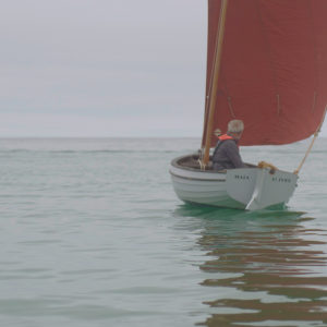
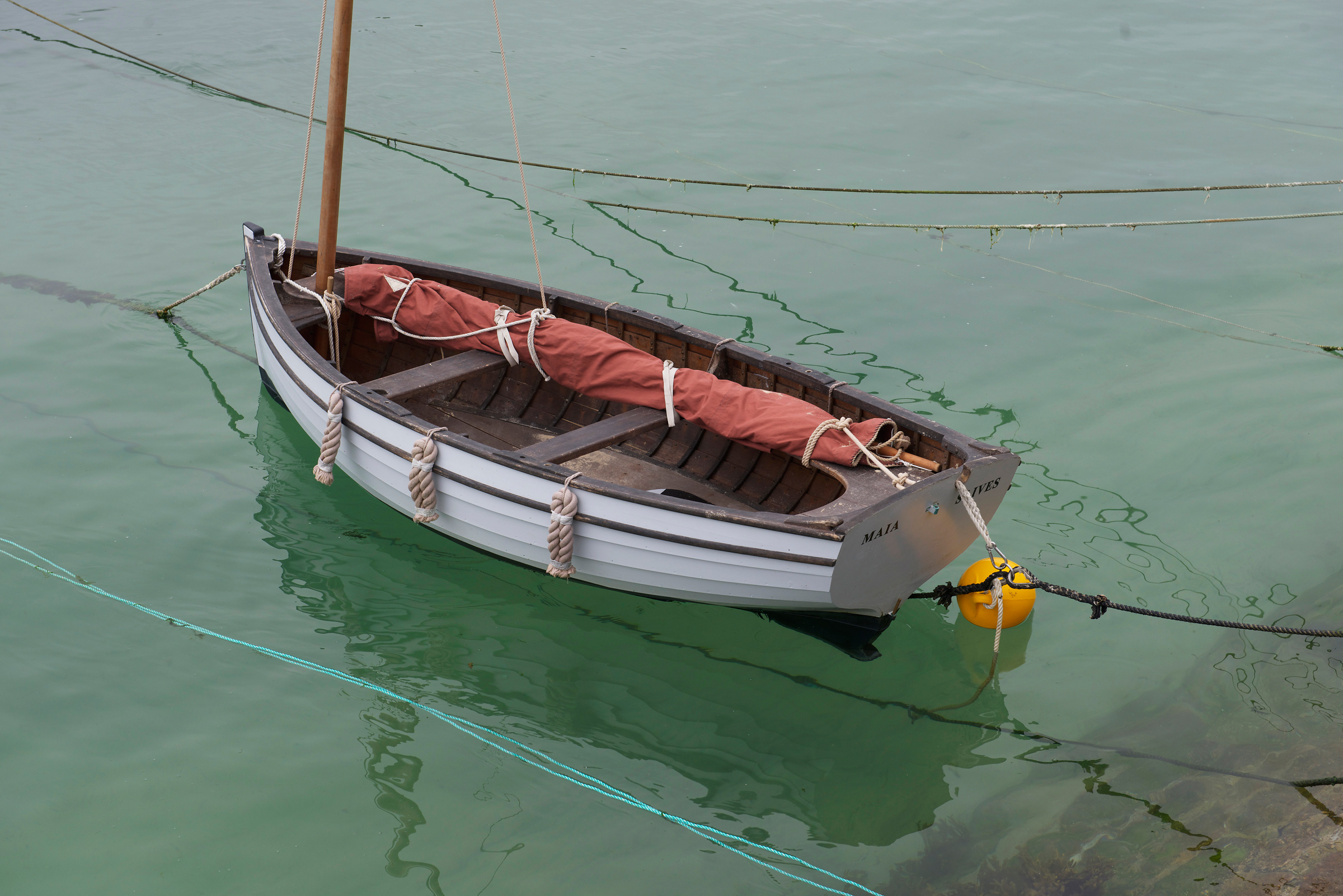 Photographs by the author