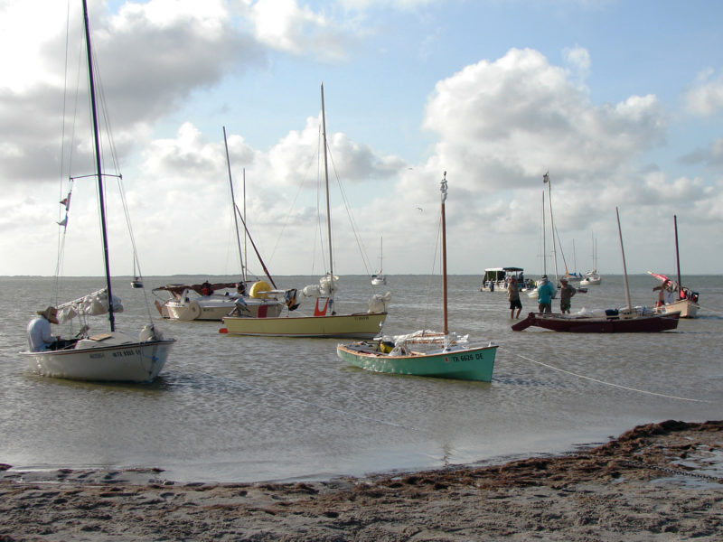
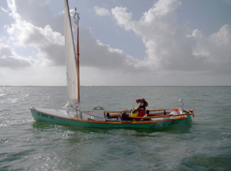
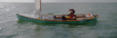
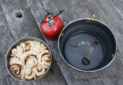
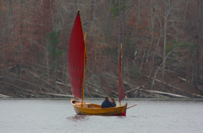
ARR & ARR, my homemade Ross Lillistone-designed Flint, surged north-northwest under reefed sail in the Lower Laguna Madre on the Texas Gulf Coast. It was midday on a hot Monday in June, and I would be in the 14′ 10″ open boat all day every day through Friday, so I was covered from head to toe to prevent sunburn, insect stings, and lacerations. I had a neck gaiter pulled up over my nose and ears, a wide-brimmed hat, UV-blocking gloves, and neoprene booties to protect my feet from mud riddled through with jagged shells that would steal shoes, slice skin, and rub in flesh-eating bacteria. I had just begun the Texas 200.
It wasn’t as if my gut hadn’t tried to warn me back at Port Mansfield the day before, as soon as I had put the boat in. I had secured my boat in the marina slip and walked down the dock looking at other boats that had arrived for the 200, recognizing some from pictures and videos posted to the Texas 200 Facebook group and excited at finally seeing them, including the FLYING M and a Bolger Featherwind named HELLO KITTY. After a few hellos to the boats’ crews and a brief conversation or two, I walked back down the dock, and at first my slip seemed empty. Only after a few steps did I finally see my Flint way down low on the water taking up a smidgen of the available space, like a water bug in a swimming pool.
A heavy lump had settled in my gut, and I wondered then if I might have misjudged myself and my boat. I tried to reassure myself that the forecast for the week was favorable, only fair and following winds at 10 to 15 knots. The lump wasn’t going anywhere, though, and I wondered if I should pull the boat out and drive home.
 Photographs by the author except as noted
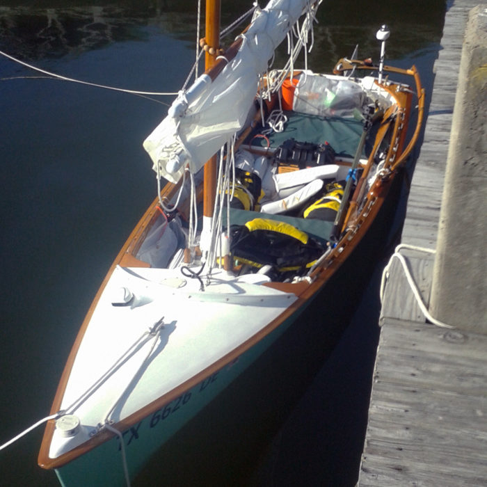
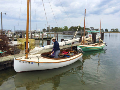
ARR & ARR lies in its slip at Port Mansfield close to the start of the Texas 200, about ready to shove off. Drybags and sealed buckets loaded with lightweight, bulky gear and lashed down to anchor points at the bottoms of the frames ended up functioning only marginally well as makeshift emergency flotation.
In the morning, before the captains’ meeting, I stopped by the docks again. The sun was just below the horizon, and the sky glowed mango yellow. My boat was fine, but it still seemed so tiny and low. I told myself I could join the other entrants and drive to Port Lavaca to park our cars and trailers near the finish line, have lunch, and then decide whether to get on the charter bus taking us all back to our boats at Port Mansfield or to drive my car and trailer back to Port Mansfield and pull out of the event. There was still time to mull it over.
When it came time to get on the bus, I joined the others. As fields of corn and sorghum and windbreaks of oak and mesquite drifted by at 70 miles an hour outside the bus window, I told myself I could withdraw anywhere along the route. It would be more logistically challenging with up to 200 miles separating the boat and the trailer, but it would always be an option. My satellite tracker had buttons that could send three different messages home to my wife, Victoria, in Austin; I’d programmed one to say, “Life and limb are not in danger, but I could use your help. Please meet me wherever my track eventually stops.”
The next morning, I carried my last three dry bags of gear down to the slip, finished loading the boat, cast off, and rowed out of the harbor. The lump was gone. It seems that it fed on idleness, and I had had things to do that morning.
 Roger Siebert
.
When I rowed out of Port Mansfield I was almost certain I was the last to start this year’s event. I hadn’t expected to see more than one or two other Texas 200 boats until I reached the first camp, but there they were, at least one sail on the horizon far ahead and one or two on the horizon behind. Boats that caught and passed me flew the Texas 200 burgee and crews aboard hollered and waved.
The winds were a perfect 10 to 15 knots and building, and my destination for the evening lay another 10 miles downwind. The water was dark olive green under mostly sunny skies, and as each wave caught me, it lifted my boat’s stern, hissed and gurgled its way forward just beneath my gunwales then rolled off ahead, a lacy train of foam on its back.
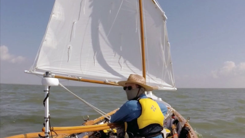
The Texas 200 started in the Lower Laguna Madre without much wind, but by midday I had to put two reefs in. It may look like there is a lot of loose gear in the cockpit, but everything stored outside the boat’s buoyancy compartments was tethered to the boat or to me on the assumption that everything on board would at some point try to jump ship and either sink or float away. The tethers paid off later in the day when ARR & ARR capsized.
Land lay at the horizon to the left and right, but it had changed from thin, mostly gray fuzzy lines in the distance to thicker green ones near enough to make out the wind turbines strung out all along the mainland coast. The land closed on me over the next few miles until I entered the Land Cut, where the Intracoastal Waterway (ICW) becomes a 20-mile-long, 100’-wide dredged path through the Saltillo Flats, a low-lying stretch of mud, shell, sand, and salt flats. Spoil islands lie on the east side of the channel, mostly covered with scrub and grasses, some bearing fishing shacks. Smaller cuts lead away from the channel into the flats on both sides.
The wind had been shifting from southeast to more easterly throughout the day, and at the start of the Land Cut, the channel turned slightly east of north, which put me on a beam reach. The water was only ruffled, but the wind was barely hindered by the spoil islands and made for some exhilarating sailing.
What appeared to be the last of the sails behind had come near enough to tell that it was the Pathfinder I had first seen at Port Mansfield Harbor two days earlier. My boat seemed to have slowed to only a knot or two, so I figured it was the perfect time to shake out a reef and put some distance between me and the Pathfinder again.
I hadn’t gone half a mile with that reef out when an exceptionally strong gust hit and heeled the boat over hard. I let the sheet fly, but it was too late. The leeward gunwale submerged, the boom hit the water, the wind pushed the boat on over onto its side, and I plunged in feet-first.
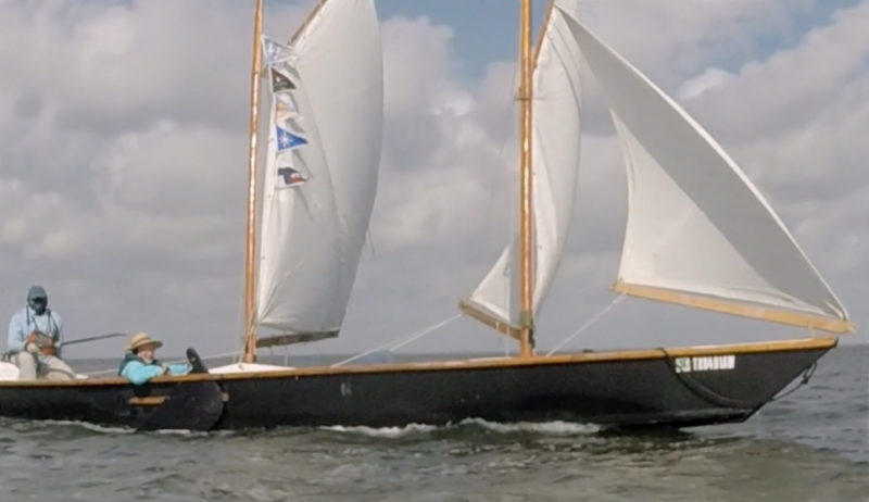
I righted the boat and reboarded, and the Pathfinder, Peter Menegaz’s FLYING M, pulled alongside, luffed, and slowed to a crawl. Peter and his crewman Joe asked if I was all right. Joe offered a bilge pump, but I declined, figuring I could empty the water faster with my bucket.
FLYING M circled while I emptied the water and put the reef back in my sail. I sheeted in and got moving again, and FLYING M fell in behind me. The capsize and recovery had taken only minutes, and I was embarrassed but cooler for the dunking.
The Texas 200 is not a race. No one seems to care who reaches the finish at Magnolia Beach first, and no one records results anywhere that I know of. You challenge yourself, not others, which made my failed attempt to outpace another boat even more ridiculous.
FLYING M followed me all the way to the first camp, a mud and sand beach on the spoil island side of Land Cut, the dredged channel between Lower and Upper Laguna Madre. I beached my boat just inside one of the side cuts that heads out into the flats. My feet sank in the mucky sand beneath the shin-deep water next to my boat, but on shore, the footing was firm as I lugged camping gear from the boat to the dry spot I had picked out among the yellow beach daisies and fleshy green glasswort.
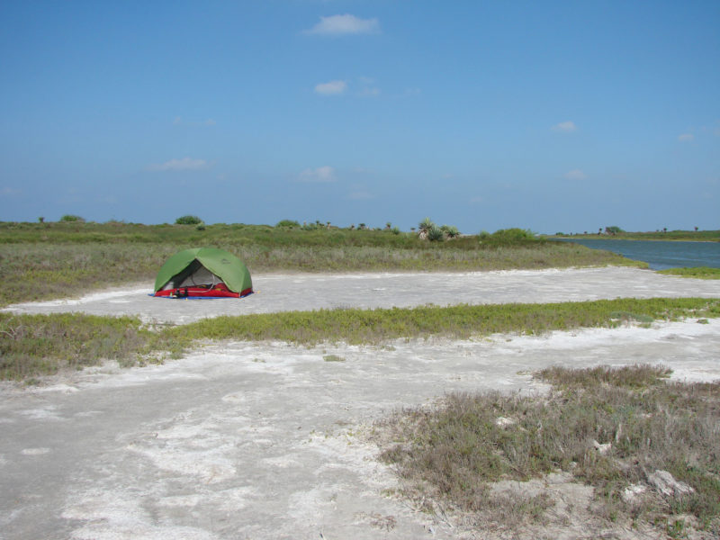
On the first night we camped on one of the Land Cut’s spoil islands. I set my tent near a side cut, visible at the right, that leads out into the Saltillo Flats.
My original plan was to take the battery that powered the boat’s electrical system inside the tent each night to recharge my cell phone, handheld VHF, and video camera, but the capsize had fried the battery. My phone had been on all day, so its battery was mostly drained. I had packed two spare phone batteries, an older one that holds only about half a charge and a new one. I decided to reserve the older battery for emergencies and to save the new one for the fourth day of the 200, when I’d need to navigate through passes in almost a dozen oyster reefs over a course of about 40 miles.
Just beyond our camp was a fishing shack, a ramshackle box missing huge swaths of siding and with exposed, rotting rafters, sitting on a pier that was missing almost half of its planks. Still, the shack provided the only shade at the camp, and sailors filled almost every inch of that shadow.
I returned to my tent and nibbled at a mix of dried fruit and nuts—what was supposed to have been my lunch—debating whether I wanted to also heat up a dinner. Kim Apel walked over from the next tent and insisted that I join him and his group after they got their gumbo going. I ended up in a long conversation with Joe and so missed out on the gumbo, but I was grateful for the offer, and it felt good to be among such people.
At dusk I crawled into my tent, its flaps rolled up to prevent it from becoming a sauna, and bedded down. The wind stayed strong into the night and beat, fluttered the rolled-up flaps, and drummed the windward panels, which kept me from falling asleep for a good while.
I woke during the night to a deep thrumming permeating the night air. A tugboat was pushing two barges through the Land Cut, appearing ghostly gray in the light of a gibbous moon. After the tugboat passed, it revealed all along the western horizon, countless blinking red lights atop the mainland’s long stretch of wind turbines. I kept an eye on our boats pulled up along the shore to see if the tugboat’s wake might do anything that would need attention, but it left barely more than a ripple. A few of our boats adjusted their haunches, as if snuggling into different sleeping positions, and that was it.
I woke again while it was still dark, feeling rested but hungry. With my phone turned off, I wasn’t sure what time it was, but I guessed from the position of the moon that it was close to dawn, so I made a cup of coffee and ate a baggie of granola with milk. A coyote yipped in the distance. Shortly after breakfast, the eastern sky lightened, and other sailors began to stir, so I broke camp and loaded the boat.
The wind hadn’t slackened overnight, so I left the two reefs in my sail, humbled into taking more care after my dunking. Through the morning’s sail, the clouds grew more numerous and larger, their bellies turning gray while still glowing bright white around their edges. Each time I felt like shaking out a reef, I glanced behind and saw the gurgles and foam in my wake slipping away at 3 or 4 knots, and I left things alone. I scarfed down a bit of jerky and an energy bar while I was still in the Land Cut and had the chance, assuming I would have my hands full managing the boat later in the day.
The day turned windy, with gusts reaching 25 knots. In Baffin Bay, with the waves on my quarter and building, my push-pull tiller required a fair bit of force to keep the boat from broaching. The daggerboard tapped against the sides of its slot, spilling water into the forward section of the cockpit. Sharp wave crests lapped a cup or two over the windward gunwale. The waves were only 2′ tall, but big enough to push my boat around.
A half dozen dolphins surfaced around my boat; two leapt half out of the water right next to my bow. I had been quite anxious about the waves and the water coming aboard, but the dolphins, playing as if we were in a kiddie pool, calmed me. ARR & ARR apparently wasn’t going fast enough or creating a big enough bow wave for the dolphins, and they soon they headed over to a small sloop gaining on my starboard quarter.
After I crossed the bay, I ducked in and out of the shelter of some spoil islands, and where the waves were smaller I could move to the center thwart and sponge out the water that had spilled into the forward half of the cockpit. When I built the boat, I thought about running a couple of tubes through the bottom of the center-thwart buoyancy compartment to allow shipped water to flow aft where I could bail it out. I wished I had done that.
ARR & ARR rests on the bottom in only inches of water at Camp Two, on the west side of Padre Island, about halfway between Baffin and Corpus Christi Bays. Other Texas 200 boats here include a Bolger Dovekie (cream topsides and leeboard); a sloop designed and built by the late Joe Dobler (yellow topsides), renamed JOE COOL by its current owner; and a couple of Jim Michalak-designed Mayflies (dark brown boat and tan boat at right).
Camp 2 was on the western shore of Padre Island. The ground was sandy and flat for about 100’ inland, where it rose up in grass-covered dunes. Between the shoreline and the dunes, a meandering rivulet of water snaked inland from Laguna Madre. A black skimmer swooped in and raced within inches of the water angled its lower bill almost straight down, ripping a miniature bow wave and wake down the rivulet’s middle.
The next morning, on the way to Corpus Christi Bay, the wind blew 10 to 20 knots across water sheltered by Padre Island, so I made good headway on nearly flat water on a broad reach, even with two reefs in. Four dolphins rose from the dark olive water right next to me. One surfaced so close that I could have reached out and touched its curved, gray back.
The winds built and became more easterly as the day progressed. By the time I entered the bay, the wind had backed from my quarter toward my beam, and with a fetch of 2 to 3 miles, the waves built up to 2′ again. The boat started taking water. I heeled the boat to raise the weather rail, but there was a limit to how much I could do that without dipping the lee rail, and as wave tops continued to splash aboard, water accumulated forward where I couldn’t get to it.
I headed up toward the windward shore to get into sheltered water; sailing on a close reach left my starboard flank less exposed and only a few wave tops spilled aboard.
On the morning of Day Three, we sailed north along the 42-nautical-mile length of Upper Laguna Madre on the way north to Corpus Christi Bay. The lagoon is 5 miles wide and yet has an average depth of only 3’. The stern light is wired to a 12-volt system that powers the boat’s lights, horn, and sound system.
The chop stirred up the bottom across miles of shallows, turning the water gold under the midday sun. I closed on the windward shore until I was in calmer water, where waving swaths of dark brown sea grass waved across the bottom. Water had almost filled the forward part of the cockpit, and instead of turning to parallel the shoreline and sponging out as I sailed, I beached the boat and took a break. I pushed the button on my satellite tracker to send Victoria the preprogrammed message that I wasn’t on my planned route, but everything was okay. I bailed out the boat and tucked my last reef.
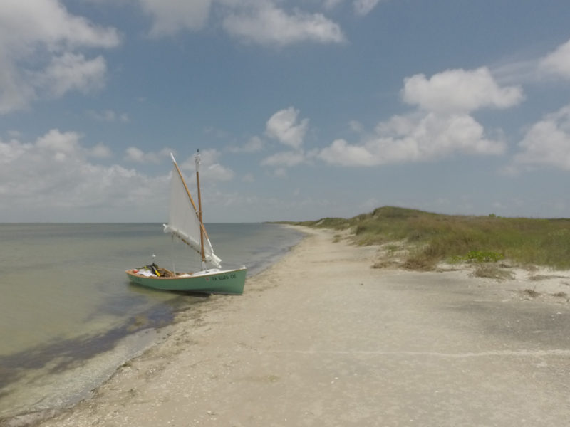
It was a gorgeous beach, with calm water, fine sand, and grass-covered dunes. I checked my chart and found my position on Mustang Island. I pushed my boat into knee-deep water and climbed aboard, eager to get going again. I was glad to have the company of the two other boats, even if for a short while. Within a couple of miles, the Hobie left the sloop and me behind, and I followed the sloop through Shamrock Cove and toward Stingray Hole, where the sloop went around Point of Mustang and also disappeared. I was undercanvased, but I didn’t want to shake out a reef and then have to hike out. I wanted to keep my weight low for stability and to be able to move forward when necessary to sponge out the cockpit.
ELSIE B, a folding schooner, passed me in the Intracoastal Waterway on the way to Corpus Christi Bay on Day 3. On the gunwale at the boat’s middle is a large hinge that allows the boat to be folded in half for transport and storage. ELSIE B has participated in every Texas 200 so far and is the model for the Texas 200’s logo.
I arrived at Camp 3, Mud Island, about two hours before sunset, to the sight of nearly 60 boats pulled up all along the shoreline. This year, the Texas 200 offered two routes; the traditional 200, from Port Mansfield at the southern part of the Laguna Madre to the finish at Magnolia Beach; and the “Hard Way,” which started at Magnolia Beach, joined us traditional types at Camp 3, and then headed back to the finish back at Magnolia Beach along with the rest of us. Mud Island was the first time the two fleets were combined as one.
After setting up my tent, eating a hot meal, and studying the next day’s route on the charts, I was disappointed that not enough daylight remained to walk the beach to see the Hard Way boats and meet many of the sailors I had read about.
Day 4 was the longest, at 43 nautical miles, and most difficult of the trip. Some of the oyster reefs would be easy to avoid—the deep-water gap between Poverty and Spalding Reefs is about a quarter mile wide and easily negotiated with chart and compass alone. Other passes, like that between Cedar and Ayres Reefs, were narrow, and sometimes winding, requiring either local knowledge, a GPS device, or the patience to slowly poke and prod your way along. Day 4 was what I had saved the better of my two charged phone batteries for, and I wasn’t sure how long it would last while constantly operating a navigation app with the phone’s GPS enabled, so I checked and double-checked my planned route for accuracy in case I had to fall back on navigating with chart and compass.
I launched shortly after sunrise but was still behind half the fleet, a loose trail of sails sprinkled across the water all the way to the horizon. Behind me came FLYING M and one of the Hobie trimarans. The air felt cool with the sun still mostly tucked behind clouds at the horizon, and my boat left a gurgling wake in nearly flat water. The more Mud Island shrank behind, the more fetch the wind had to build the waves, and I was soon pushing and pulling the tiller to stay on course again. The action wasn’t as extreme this time and the sailing was actually pleasant.
FLYING M and I sailed side by side only 100 yards apart as we neared the wide gap between Pauls Mott and Long Reef. A line of white tumbling wave tops appeared directly ahead of me, running out from Pauls Mott to starboard. I turned to port and aimed around the farthest edge of the churning waves and toward FLYING M, but I hadn’t reacted quickly enough. My daggerboard plowed into the shell bottom. I spilled the air from the sail and jerked the daggerboard up. The grinding ended, and ARR & ARR moved ahead again. Once the churning waves were behind, I pushed the daggerboard back down clear of the boom. FLYING M had pulled ahead during my grounding, and I fell in behind them on a course that would take us between Poverty and Spalding Reefs 2 to 3 miles ahead and then to the more challenging Cape Carlos Dugout.
Before this trip I was worried about having a daggerboard instead of a pivoting centerboard. When the daggerboard hit bottom—and in the Texas 200, it is “when,” not “if”—something would break or the boat would capsize. Because I was mostly sailing downwind, I kept the daggerboard as high as I could without allowing its top to get in the way of the boom and had originally thought that my kick-up rudder blade, sticking farther beneath the surface than the mostly raised daggerboard, would warn me when I got into less than 2 feet of water. But the daggerboard always hit first. Sometimes it would grind on the shell bottom like at Pauls Mott, and at other times it would hit mud and feel more like I had firmly pressed a brake pedal. The boat was never moving so fast that it broke anything or capsized. After the shells on the bottom had worn down the edge of my daggerboard, it was easy to shrug off additional damage and accept that it had become my makeshift depth sounder.
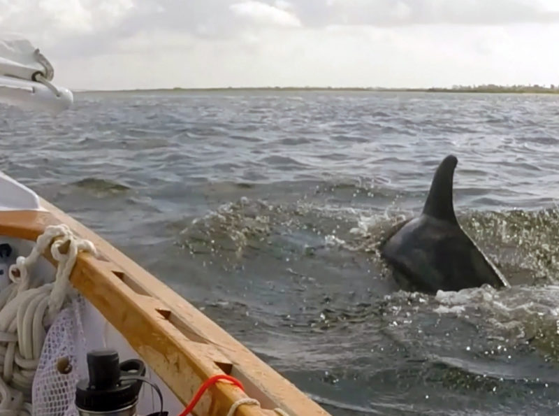
Dolphins are a common sight in the Texas 200, and they are not at all shy. One surfaced repeatedly next to ARR & ARR on the approach to Corpus Christi Bay on Day Three.
Cape Carlos Dugout and Cedar Dugout were unexpectedly easy channels to navigate. I had my phone’s navigation app, the pilings marking the channel, and FLYING M traveling the same course only 50’ ahead. It was easy to be cautious as the water in the dugouts was smooth between the surrounding reefs and a shortened sail nudged me along at only 2 or 3 knots. In Cedar Dugout, the water lapped the edge of a long shoal only inches deep to starboard, and a few dozen bright pink roseate spoonbills sauntered ankle deep on the shoal, a few here and there dipping and swishing their long paddle-like beaks.
After crossing Mesquite Bay, I followed the bottom contours of my navigation app into Ayres Dugout, which ran adjacent to a small island with a short, steep beach. Three or four boats were pulled up on the beach, so I came ashore for a quick break too. One of the sailors helped me land and held my bow until I got out and took the boat from him. I thanked him, pulled the bow onto the beach, and began sponging out the forward area of my boat. The other crews relaunched and sailed into Ayres Bay on a path that would take them around the southern edge of the Second Chain of Islands. They seemed to be following the course I had plotted for the bay, so I quickly tucked my sponge away and shoved off to follow them.
Little by little, their sails shrank in the distance ahead. After I entered San Antonio Bay and set my course northeast toward Panther Reef Cut, the other boats passed Ayres Point and turned more eastward, toward the southern edge of Panther Reef and much closer to Matagorda Island. The water would be calmer there, which was enticing. On my chart, I didn’t see an obvious path through the reef where they were headed, but I knew that at least some of those sailors had completed previous Texas 200s and wouldn’t be going that way if there weren’t a way through.
After I passed Ayres Point, I turned toward the other boats and shot a bearing on their cluster of sails so I’d know what course to steer after they’d disappeared over the horizon. I wished I had plotted several courses for each day, a primary course and a couple of alternative ones. As it was, deciding to alter course meant juggling phone and chart and trying to memorize new courses on the fly.
I pulled out my phone to see where my new bearing would take me, knowing that the navigation app would show greater detail on the depths at the reef and probably the way through, but my phone’s battery was dead. I pulled out my chart and between double-checking my course against the sails on the horizon, steering the boat through the waves, and glancing at the chart to figure it all out, I determined I was heading toward Pelican Point some 5 or 6 miles distant, with the low green line of Matagorda Island stretching across the horizon to starboard a mile or two away.
I was back on a close reach, but the waves remained choppy and water continued to come aboard. Whenever the chop subsided for three or four waves, I crept onto the main thwart and sponged out some of the water, and whenever the chop steepened, I pointed higher to take them more on the bow, but still, little by little over the next 4 miles, the water coming aboard outpaced my sponging and was within inches of the top of the main thwart in the forward area.
The boat was sluggish as a result, and of course the water always went to the side of the boat that was lowest, which was like having a crewman constantly moving to the wrong side of the boat. On one steeper dip to leeward, water flowed over the lowered end of the main thwart into the part of the cockpit I occupied. I leveled the boat and bailed that out. I was pleased with the discovery that I could shift some of the water aft simply by heeling the boat, and then could bail it out from where I sat.
 Asmus Freytag
With me and all gear aboard, the ARR &ARR floats low in the water, while sailing in Aransas Bay on Day 4. I had reduced my original inventory of gear from 240 pounds to 150 before leaving home, but I could have ditched more. I carried water for the entire trip, but I could have taken on fresh water at Corpus Christi, halfway into the 200, and carried only half of the 65 pounds I had on board at the start. A lighter anchor with less chain would have helped as well.
I wanted to land somewhere I could bail everything out. A pair of white beaches lay about a mile dead ahead, and I was still within about a mile of Matagorda Island to starboard. I couldn’t tell whether the white beaches to the east or the green land to my southeast were closer. I checked the chart and figured out roughly where I was, and it appeared even on the chart that I was about equidistant to both shorelines. The beaches to the east were closer to my destination, so I continued toward them.
As I approached the two beaches, the gap between them grew. I aimed for the windward beach, so I could use the leeward one as backup in case I had more leeway than I was guessing or in case the wind backed before I got there.
I sailed and bailed, but it was difficult to keep up with the water coming aboard. The more water the boat had in it, the faster it came aboard. It sloshed around 6” deep even in the main area where I sat, and I became disheartened with the whole trip. I couldn’t help concluding that it had been stupid of me to enter the Texas 200. It wasn’t the boat—it was a good boat, just not the best choice for me for this event. It wasn’t the conditions—wind speeds were perfect, and the chop was only 2 feet high. It was my lack of experience—I had sailed this boat in windier conditions plenty of times, but not in such shallow waters and in this sort of chop.
I wasn’t in danger. Land lay on every side, albeit over the horizon much of the way around; the water was wading depth sometimes a half mile from shore and so warm that hypothermia was virtually impossible. My boat has somewhere around 600 lbs of buoyancy and would float fully swamped. Indeed, it can still make headway under oars while swamped. The most realistic threats were sunburn and dehydration, but I had plenty of sun protection and drinking water. What seemed threatened more than anything else was my pride, and the fact that I was even thinking about such a dumb thing irritated me. So the boat slogged toward shore at about a knot, and I bailed and bailed, grumbling at myself for worrying about how stupid I might appear for—get this—having been stupid.
I was only a couple hundred feet from the searing white beach on what I guessed was Pelican Point when the daggerboard grated against the shell bottom. I pulled the board out, clambered overboard, and dragged the boat toward shore, more relieved than happy. I was too tired and disgusted with myself to be happy.
As I waded, the bottom dipped once, from thigh to sternum deep, but then rose again, continuously this time, until I had the boat’s bow pulled up on shore. I bailed most of the water out then pulled the boat higher onto the beach to finish bailing and sponging.
The beach was steep and made of coarse shells almost too bright to look at under the afternoon sun. A light breeze came over the ridge of greenery inland, and it felt pleasantly cool because I was drenched up to my armpits.
I flipped the page on the chart book looking for the spot where everyone would converge for the night’s camp, Army Hole, an abandoned airfield near the far end of Matagorda Island, but it wasn’t on the chart. I flipped another page. There it was, still at least 15 miles away. It was already midafternoon.
I tucked the third reef in the sail, pushed the boat out to thigh-deep water, and climbed aboard. It was good to have a responsive boat again. I sailed around Panther Point without grounding, although the chart showed only 1’ of water there, and stayed within a mile of the shoreline for the 6 or 7 miles to the First Chain of Islands. There were times when water would still sneak aboard, but I knew that the more water I had aboard, the more work it would take to match the pace of the ingress, so I sponged it out as soon as it came in. With less sail up, and with the responsiveness of a drier boat, it was easier to sail even while forward removing water. While it helped that the chop was gentler this close to the windward shore, I suspected I’d gotten at least a little smarter about how to handle it all. Whatever the case, I was enjoying myself again.
The Corpus Christi Bay side of Mustang Island provided the perfect opportunity for a quick break. The Gulf side of the island sees people take a break of a different sort, Spring Break, when thousands of college kids descend upon the miles of broad, sandy beaches.
A lime-green Goat Island Skiff shot by with almost all sail up, passing me about 100 yards to starboard. It was John Goodman aboard GIR. He yelled out “Woo-hoo!” as raced ahead on plane, heading straight for the islands I had set my course to. It felt as if Superman had swooped in to show me the way through.
I followed GIR as she headed straight for what appeared to be a small wooden water tower on one of the islands. GIR shrank in the distance and doglegged left, cutting around the northern edge of the island.
I followed, although at a fraction of the speed. I cut left at the water tower, and then doglegged back right at the island’s edge, and my daggerboard ground to a halt on the oyster-shell bottom. I got out and walked the boat to deeper water, got back in, and promptly ground to a halt only 50’ farther on. I walked the boat again and, that time, left the islands behind.
I was elated that GIR had shown me a way through and that only deeper water remained between me and Army Hole. I had 8 or 9 miles to go but there would be no more reefs.
About 4 miles later, as I approached Vanderveer Island and the last stretch to Army Hole, the sun hung low in the sky, about to duck behind the denser cloud cover at the horizon. I doubted I’d reach Army Hole before dark, and I didn’t want to be on the water at night. Every once in a while, a wave top tossed a pint or so of water into the front of the boat, and water was sneaking in through the daggerboard slot again. I sponged it out but I wasn’t ready to shake out a reef.
Ahead there appeared to be beaches suitable for campsites dotted along the Vanderveer Island shoreline. I considered heading for one and setting up camp by myself while it was still light and meeting up with the rest of the boats at the finish the next day. I could send Victoria two messages: one letting her know I was stopping for the day and another letting her know that although I wasn’t on my planned route, everything was okay.
I continued to skirt the island and rounded the turn in the island, and with the sunlight coming from behind me, Army Hole’s long main building and picnic pavilion roofs gleamed white against the darkening horizon ahead. The final 2 or 3 miles would be in the lee of Vanderveer Island, which meant flat water the entire way, so I crawled forward and took out a reef. ARR & ARR sped up, but it still didn’t seem fast enough. As the sun had slipped to within a few degrees of the horizon, I shook out another reef, sat on the gunwale, tucked my toes beneath the hiking strap, and pulled in the sheet. The boat took off, and I thought I might make it after all.
The sun set when I was about a mile out, and the light and the wind faded, but I was so, so close. I was too close to save any time by stopping and shaking out the last reef, so I kept sailing.
I made Army Hole in the last of the twilight, and another sailor helped pull my bow onto the grassy shore. I set up my tent in the dark, slipped inside, and ate a quick cold dinner. I was wet, hungry, sore, and exhausted, but I had made it, more than 40 nautical miles in one very long day. I stretched out on my sleeping mat in my still-damp clothes and fell into a long, deep sleep.
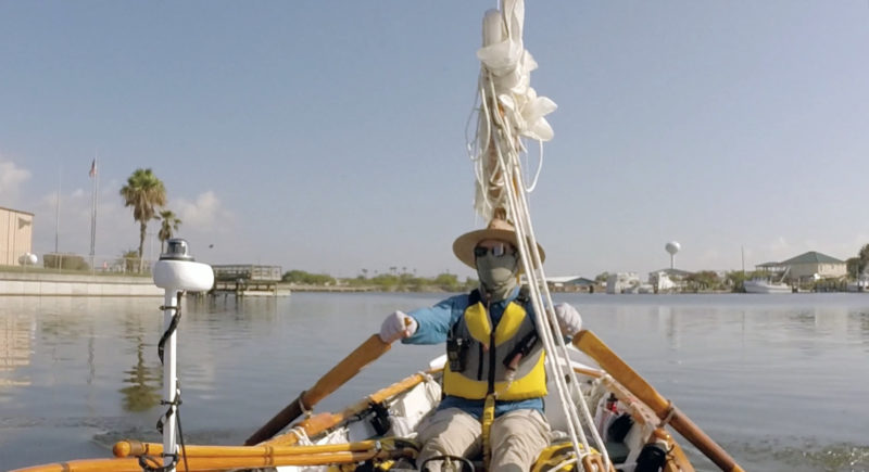
Spending five days with the Texas summer sun beating down on and reflecting off of the water makes complete coverage a necessity. Previous Texas 200 participants have had to drop out as early as Day Two from sunburn alone. Lightweight, quick-drying synthetic pants and shirt are best—cotton doesn’t provide adequate protection, especially when wet. Carrying a change of clothes prevents daily apparel from becoming too foul. I had only one neck gaiter and it was quite rank by the end of the event. I enjoyed my separate set of sleeping clothes—a pair of shorts and a T-shirt until Day Four when water seeped into their dry bag and soaked them. The bicycle mirror provides a limited but useful view of where I was heading when I was rowing. I commute by bicycle, so I was already used to that type of mirror.
It was already light when I woke to the last day of the 200. Only about 20 miles of easy sailing lay between me and the finish at Magnolia Beach. I took my time eating breakfast, taking down the tent, and preparing the boat.
Most of the fleet was already gone by the time I pushed off. The wind blew a steady 10 to 15 knots with gusts up to 20, and I had 4 or 5 miles of a broad Espiritu Santo Bay to cross, so I sailed double-reefed.
The bay is only about 6′ deep, so the waves were choppy, even if only about 2′ high, but they were regular and going my direction. With the steeper sets, water sprayed outward from the gunwales.
Water flowed from the daggerboard trunk into the forward cockpit, but I’d lashed an empty 5-gallon water can in that part of the cockpit and functioned as a buoyancy tank, making it unnecessary to bail. I made good headway across the 4 ½ miles of Espiritu Santu and threaded through the ruins of more than a dozen platforms about halfway across the bay, so I certainly wasn’t at risk of dozing off or anything, but the whole thing seemed routine by then. Just outside the entrance to the channel between the islands, a lone dolphin surfaced 50′ off my port bow. It moved slowly and surfaced only once. Its dorsal fin had a chopped, jagged edge; an old wound likely from a boat’s propeller. I felt for the poor thing but admired its resilience.
 Roger Siebert/Ross Stapp
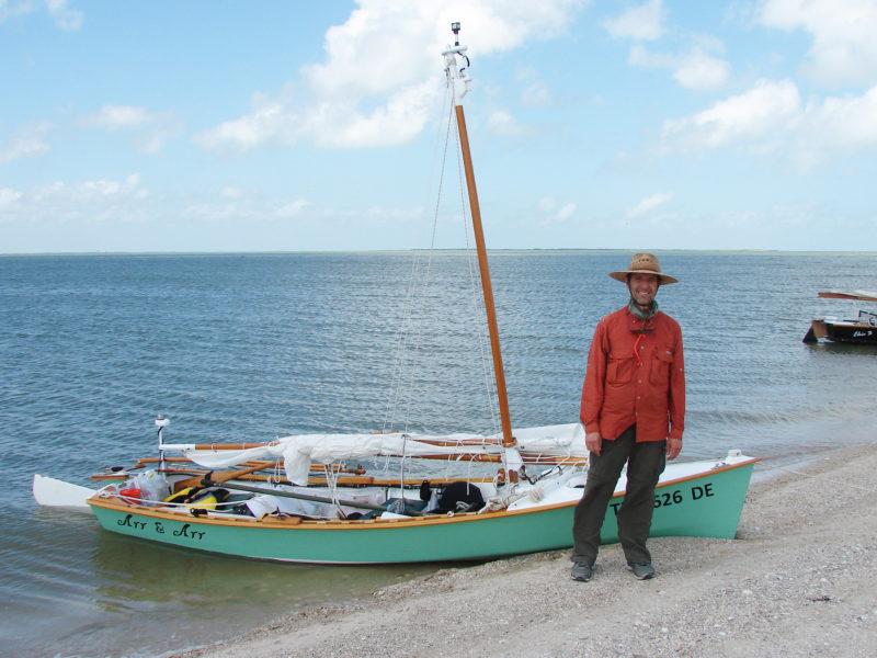
I was all smiles at the finish at Magnolia Beach. Beaches like these, made up of coarse shell fragments, may seem benign, but even the slight rocking caused by waves as small as these would wear through paint in just a couple of hours.
I negotiated the narrow 1/3-mile-long passage between Dewberry and Blackberry islands and sailed into the sheltered waters of the 175-yard-wide ICW channel behind Blackberry. After about 5 miles of dodging barges and powerboats, I exited the channel between the twin jetties at Port O’Connor, and headed northwest toward Magnolia Beach, sailing the last 8 or so miles in the lee of the shore, close enough to stay sheltered but far enough out to enjoy the ride. I landed on Magnolia Beach, the finish of the Texas 200. It had been a long, wet, hot five days with plenty of stumbles, but with a wealth of amazing moments too. At the post-event dinner, I stuffed myself with shrimp, sausage, corn, and potatoes and swapped stories with the other sailors. I hadn’t even pulled the boat out of the water yet, and already I wanted more.![]()
Roger Siebert is an editor in Austin, Texas. He rows and sails his Flint on local lakes, and has trailered it to a few of his favorite places on the Florida coast.
The Ross Lillistone Flint
The Flint is a 14′ 10″ open boat Ross Lillistone designed primarily as a rowboat but which can also take sails or a small motor. It’s built using 1/4″ plywood and dimensional lumber. A profile of the design appears in Small Boats Monthly’s October 2016 issue.
I built my Flint to use the 55.7-sq-ft balance-lug sail. I also coated the outside of the hull with fiberglass, beefed up parts such as key joints and the rudder, added inwales and splashboards, and replaced the designed tiller with a push-pull version. My modifications added at least 50 lbs to what is normally a very lightweight boat.
I set out on the Texas 200, with about 150 lbs of gear, including a 22-amp-hour battery, and 8 gallons of drinking water. The weight turned out to be too much for the conditions, even as mild as they were. I originally thought I would have about 10” of freeboard at the sheer’s lowest point, which isn’t much. A few weeks after the event, as I was patching dings and scratches on the boat’s bottom, I noticed watermarks on the topsides that indicated the actual freeboard during the event had been only about 7″. It’s no wonder I had such a difficult time in the bays. The load also made the boat easier to capsize, in that not much heeling was required to push the leeward gunwale under.
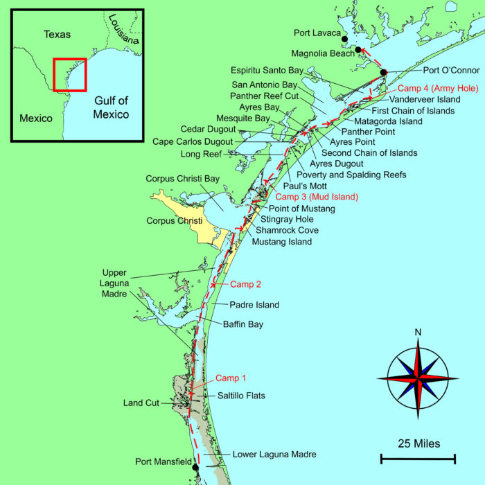
The Texas 200
Although the route runs through parts of the Intracoastal Waterway, the Laguna Madre, and the bays of south Texas and is protected from the Gulf by barrier islands, the wind can build up a steep chop over depths that average in the single digits. For more information, visit the club’s website or Facebook page.
Editor’s note: Hurricane Harvey
On August 25, 2017, the eye of Hurricane Harvey swept over the Texas coast near Corpus Christi, right at the halfway point of the route of the Texas 200. Texans from outlying areas converged on the stricken area with small boats to aid official agencies in the rescue effort. The damage caused by high winds, storm surge, and flooding has yet to be fully assessed, but it seems clear that the area will take years to recover. Donations to charitable organizations will help provide much needed assistance to Texans suffering the consequences of the storm.
If you have an interesting story to tell about your adventures with a small boat, please email us a brief outline and a few photos.
Interesting story. Anyone planning the trip should read it. Yes, a hinged centerboard and drains to allow water to get to a central bailing point would help. I couldn’t help noticing the rowing style was not good. The oars should almost meet in the middle and should not go so deep into the water on the rowing stroke or else the upper part will offer resistance in the water. I don’t think Roger enjoyed his trip but will if he does it again better prepared. I also think it would be more fun with a bigger boat and a partner to share the fun.
Hi, John. Yes, my rowing technique could use a lot of improvement. The Texas 200 showed me that a lot of my boating skills could use improvement. I enjoyed a good part of the trip, maybe even most of it, but you are certainly right that better preparation, a bigger boat, and a partner would make the entire trip enjoyable. Thank you for taking the time to read the story.
Looks fantastic, I just wonder what it is like now after the impact of this recent bad weather. Thank you for sharing your journey, a lot of learning and a lot of fun!
Thanks for reading, Robert. The editor’s note above about Hurricane Harvey (I believe added after your comment was posted) describes the situation far better than I could have. Those areas could sure use all the help we can provide.
Probably the most enlightening account of the T200 ever. A first timer sees things that old timers never notice. Thanks for that fresh view!
Thank you, John.
At last I have a true picture of the 200. Thanks so much. I don’t know whether I’m sad or glad that I’m too old to try it. (Ok, I’m sad.)
Thank you, Annie.
Annie, I have done it a number of times and will continue until I can not get in a boat. Next year I will be 78. See you there.
I read “Trial By Water “ and it is the best T200 account I’ve read, including my own. I sailed the T200 in 2012, at 84 years of age, with my grandson as crew in a borrowed Lido 14. My grandson, Douglas, was 28 at the time and plenty big enough to pull me back into the boat in the event of an event. We found the T200 arduous, but I’d do it again if I were able.
Thank you, Garry. The Texas 200 at 84 is quite an accomplishment. I hope I’m as fortunate.
SO COOL! Thank you for sharing your journey, a lot of learning and a lot of fun! A big hug from ARGENTINA!
Roger, I have built and sailed a Flint in Australia. I admire your courage and determination, and understanding the lump in your stomach before the start of the Texas 200. Well done and thanks for your story.
Thanks for a great and inspiring writeup! I live in California, and sail in San Francisco Bay, but have a hankering to sail somewhere where the water isn’t cold enough to kill you!
I admire your courage and determination! Enjoyed reading your adventure. Couldn’t stop reading. Nicely written.
Thanks for the excellent write up. Really well done.
I really enjoyed your narration, makes me wonder how you had time to remember all this stuff, thinking tape recorder maybe. It has been a dream of mine since sailing from Port Isabel back in ’63, before the Beulah Blow Down. As a Sea Scout with the local Explorer group headed by Charlie Berry, we built two trimaran sailboats from hulls donated by the Trimaran factory in Laguna Vista. We group-sailed the two trimarans, a 21′ sloop, and a old 25′ flat-bottom Tow Master called THE QUEEN from Port Isabel to the Mansfield cut and back. I’ve been having sailing dreams ever since; been with the boat people ever since. Navy, charter, and family business. But I digress. Thank you for the narrative, and one day I will put my 22.5′ StarWind in the ditch and join all of you. Again, thanks for the memories. (Sorry bout the pun, Bob.)