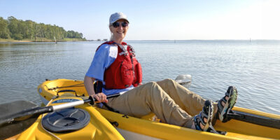
In Tasmania, Australia’s island state, there is a community of wooden-boat enthusiasts who, since 1998, have come together under the auspices of the Living Boat Trust to promote the maritime heritage of Tasmania, preserve wooden boats, and engage in water-based group activities. Every two years, the Trust organizes the Tawe Nunnugah Raid (Tawae Nunnugah means “traveling by canoe” in the local Palawa language, and the phrase was chosen by the Trust in homage to the indigenous Tasmanian people). The Raid is a fully catered 10-day small-boat expedition that starts with a welcome dinner in Franklin on the Huon River, 15 miles inland from Tasmania’s southeast coast, and finishes in Hobart, 21 miles to the northeast as the crow flies. The goal is to arrive in time for the opening of the biannual Australian Wooden Boat Festival in Hobart. In July 2024, I signed up to take part in the 2025 Raid in my Cygnet 20, RUST NEVER SLEEPS; Andrew, a fellow Cygnet 20 owner, would sail with me.
Trailering the boat, we drove to Franklin and arrived in time for the welcome dinner the night before the start of the Raid at Recherche Bay. We joined some 120 others who had come from across Australia, New Zealand, England, Scotland, the Netherlands, Canada, the USA, Spain, and France. The fleet consisted of 34 boats ranging in size from 12′ to 28′. There were sailboats, rowboats, boats with and without motors; all were wooden, with the exception of my own boat, a 20′ fiberglass gaff-rigged sailboat.
 Jan Kent
The launching ramp into the Catamaran River allowed just one boat at a time to be backed down into the water, but for each one there was a gathering of helpful onlookers eager to share their advice. Here, Andrew and I are about to launch my Cygnet 20, RUST NEVER SLEEPS.
The following morning, we drove the boats to Recherche Bay, just 7 miles from Tasmania’s southernmost point, along roads that wound through farmland and rolling hills crowned by blue gum trees and radiata-pine plantations. The area borders Tasmania’s South West National Park, home to wallabies, Tasmanian devils, wombats, and the elusive platypus. At the end of a single-lane asphalt road we congregated at the Catamaran River boat ramp. Boats were eased into the water one at a time and as each trailer made its way down the lane to the ramp, there was a general buzz, punctuated by the inevitable helpful directions: “Watch the trees, to your right! No! Your other right!”
Andrew and I readied the boat in the parking lot, raising the mast, securing the standing rigging, attaching fenders, and stowing our gear. There was a light wind rustling in the gum trees and fishbone ferns, and we were excited to get afloat. At last, it was our turn to launch and, like those who had gone before us, we negotiated the ramp, climbed aboard, motored upriver, and anchored. The morning was calm, the river a deep emerald green, the gum trees at the water’s edge standing tall, silver-barked and straight. Later, when the fleet had all launched and vehicles and trailers had been taken care of, we sailed in company to Pigsties Cove and the Moss Glen campground, a mere 1 ½ miles to the north. There was plenty of sheltered water for those of us who anchored off, but with no beach, the smaller boats simply moved into the shallows and tied up to trees on the foreshore so that their crews could step ashore to set up camp on the gentle slope above. We had arrived at our first overnight rendezvous.
 Jan Kent
Once RUST NEVER SLEEPS was safely anchored in the river, I swam back ashore to tend to the car and trailer, leaving Andrew in charge of the boat.
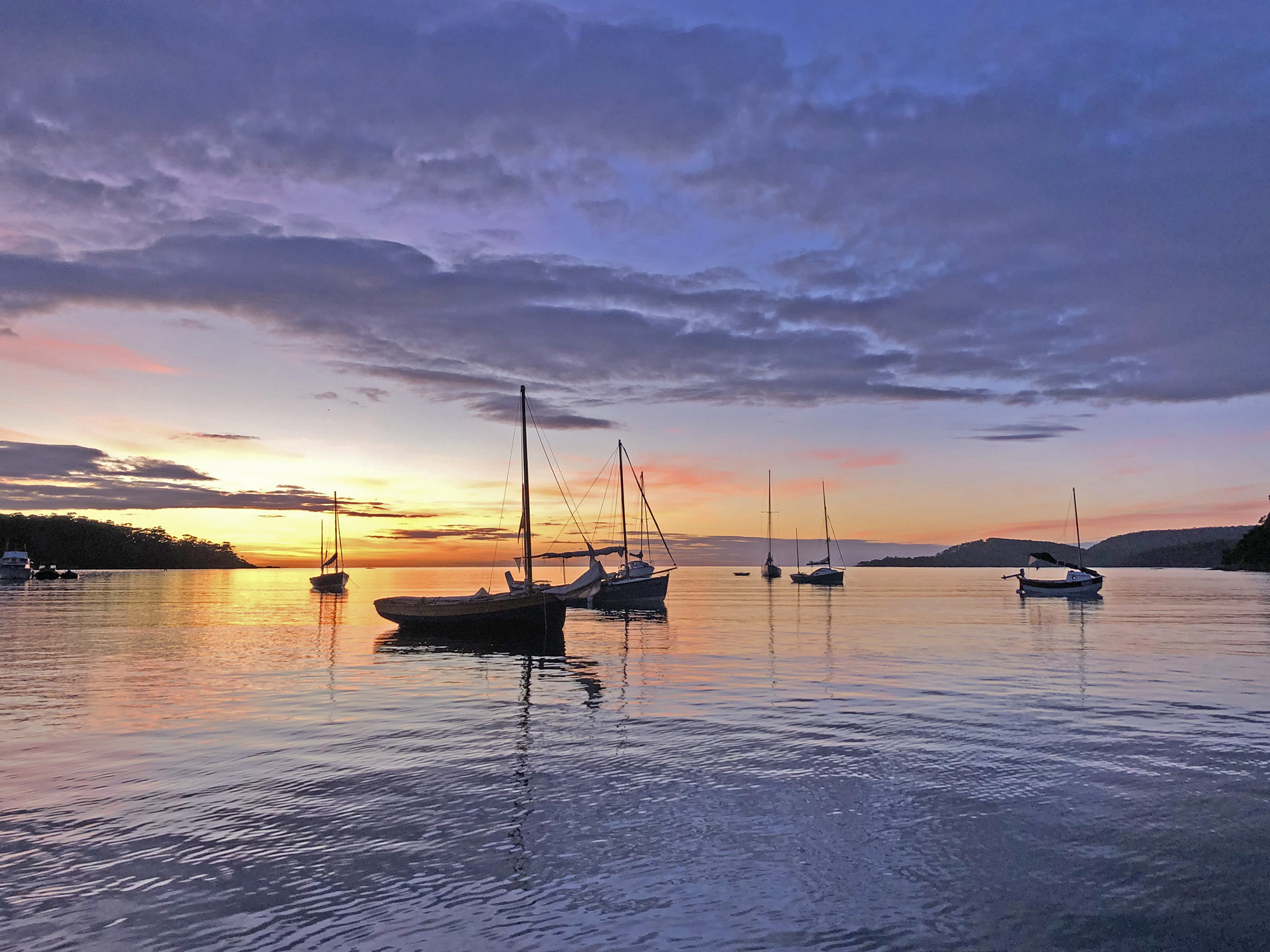
The start of the 2025 Tawe Nunnugah
Early the next morning, I sat quietly in the cockpit, enjoying the stillness and watching the sunrise paint the sky with hues of yellow, pink, and tangerine. The sounds of the bush were all around: the guttural squawk of a wattlebird, the zit zit whorl of a thornbill, the chortling deep-throated trill of magpies. From time to time a red-breasted cockatoo with pearl-gray wings passed by.
We went ashore for breakfast and to hear the plan for the day: a short 4-mile shakedown cruise south across Recherche Bay to Cockle Creek, which would allow crews to work out any kinks before we headed north. As we sailed down the cove to Shag Rock, gateway to Recherche Bay, the wind slowly built to a gentle westerly breeze. We adjusted course and set a waypoint for the red “danger” mark atop Denmark Reef, about 1 ½ miles away. There was a slight chop and the occasional white cap but nothing the boat couldn’t handle efficiently—we were cruising comfortably, and on a broad reach we passed many of the boats that had weighed anchor before us. Andrew and I spent the next hour checking everything and getting to know one another’s sailing habits. Arriving at Cockle Creek the fleet anchored or ran up on the beach for lunch. The food and company were good, and we both took time to relax before setting sail again in mid-afternoon. Andrew and I settled into sharing the helming and sail-trimming duties, alternating between being on duty and enjoying the view. As we arrived back in Pigsties Cove for a second night at Moss Glen, we were both content.
 Jan Kent
Our first morning afloat dawned bright and calm in Pigsties Cove. I spent some time sitting in the cockpit soaking up the sights and sounds of the Tasmanian coast.
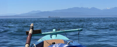
The first day of the expedition dawned. Our destination was Southport, about 11 nautical miles to the north. We motored out of Pigsties Cove and past The Images, a group of low-lying, blue-gray rocky outcrops covered in scraggly, khaki-colored bushes. Beyond the channel, in the open sea, there was a southeast breeze of about 6 knots and we raised sail. The sky was lightly overcast, the air temperature 65°F. We set a course to the northeast, heading for Southport on a broad starboard reach. To our east was nothing but 700 nautical miles of Southern Ocean stretching away to New Zealand. To our west was the coast of Tasmania, and a conservation reserve indented by windswept sandy beaches and undulating hills crowned by eucalypts, tea trees, and coastal heath.
We skirted the submerged rocks of Bowdens Mistake, their presence indicated by a mere hint of breaking whitewater, and passed Actaeon Island and its lighthouse 3 miles off our starboard bow.
 Roger Siebert
.
Three-and-a-half miles farther on, near George III Rock, a jagged granite cairn visible only in a heavy sea swell, we caught up with several boats that had departed before us. Close inshore, all were making good progress: EMMELINE, an open skiff with two rowers; IMAGINE, an 80-year-old restored naval pinnace crewed by four rowers, a helmsperson with an oar sweep, and another rower resting in the bow; and PAT C, a singlehanded open skiff. Farther out, the wind was holding steady, but within the hour it had started to increase. Our speed rose with it to a comfortable 4 knots, and just two-and-a-half hours after leaving the anchorage in Pigsties Cove we were slipping through the 100-yard gap between Southport Island and Southport Bluff. We rounded up, started the outboard, furled the jib, flaked the main, and motored along the crescent-shaped beach for 100 yards, past the Settlement Creek outlet, and dropped the anchor. We had sailed 10 1⁄2 nautical miles, and I was well pleased with our maiden sail along the Tasmanian coast.
Over the next two hours the anchorage slowly filled with the rest of the fleet. Rowboats beached and the all-volunteer water-based support crew (ranging from eight to six people as some returned to work) helped to ferry crews off anchored boats to shore. The catering team had already arrived and set up in a grassy paddock next to Settlement Creek. As crews came in, we helped to set up tables and chairs, found refreshments, and chatted about the day’s sailing until the dinner gong sounded.
Southport to Dover
At around 10 a.m. the following morning we raised anchor and set sail for Dover. It was 7 miles due north of us, but thanks to the east-northeast breeze, and the extra miles to navigate the passages out of Southport and into Dover, the voyage would total 18 miles. As we set off through Southport Bay, the wind was fickle. The tree-covered hills to windward created irregular lulls and shifts, but within the hour we had rounded Herriots Point, a rugged, scrubby-forested cape with exposed rocky cliffs, and were out in D’Entrecasteaux Channel, the 37-mile-long, north–northeast passage between Bruny Island and the Tasmanian mainland. The wind freshened, blowing straight into our faces. Over the next two hours, we tacked five times up the 3-mile-wide channel. To the east were the ochre-colored cliffs of Bruny Island’s Labillardiere Peninsula crowned by tea trees, the bright yellow burst of wattle, and the silvery-soft green leaves of gum trees.
 Jan Kent
Sailing to and from Dover, the islands of Faith (seen here), Hope, and Charity are never far away. Beyond, on the mainland, rising up above the lowlands we could see the distinctive 4,000′-high Adamsons Peak.
As we approached Scott Point to our west, sailing closehauled on our fifth tack, we spotted two large fish pens less than a mile ahead. Salmon-farm pens are typically circular, constructed of steel mesh, with floating platforms and overhead netting to deter hungry birds. They are anchored to the seabed. As we came closer, we saw that these pens were unusually oblong in shape, lying end-to-end and separated by about 200 yards of water; each was about 700 yards long and 100 yards wide. They were clearly marked with exclusion pylons and floating yellow warning marks. We observed the warnings, and negotiated a course between the pens, being careful not to get too close to either one.
Three miles farther on, we eased the sheets and changed our course to the west and the islands of Faith, Hope, and Charity. Hope, the largest of the three but still only 1⁄2 mile long, was once a burial ground for convicts. It was later briefly used for farming but is now a reserve overrun by rabbits. At the island’s eastern tip stands a 30′-tall navigation beacon. To our west, the distinctive triangular shape of Adamsons Peak, 4,000′ tall and 10 miles inland, rose above the horizon, a scattering of cumulus clouds beyond it.
The small fishing port of Dover lay a mile before us, straddling the western coastline of Port Esperance. The afternoon breeze was steady and the sun was warm. We could make out small bays and sandy beaches along the shore. With the boat flying along at 5.8 knots we took our time to enjoy the day, glancing back from time to time to see the rest of the fleet appear as they entered Port Esperance.
 Jan Kent
We were one of the first to arrive in Alonnah, and after making sure everything was shipshape on board, we stuffed some essentials into drybags and swam in to the beach, leaving RUST NEVER SLEEPS at anchor.
By late afternoon we were anchored off Dover Beach, below the Port Esperance Sailing Club. Beyond, the township extended for just two blocks, bordered inland by the state highway. It was a sheltered anchorage and, for those boats landing onshore, the sandy beach had a gentle incline. We settled in for another quiet night.
Sunday morning dawned with mill-pond conditions, blue skies, a scattering of clouds, and a clear view across the bay as we enjoyed breakfast. Our destination for the day was Alonnah on Bruny Island, 10 miles away. We would stay there for two nights. Andrew and I were in no rush and relaxed as we watched the fleet motor away from the anchorage, the rowboats gliding past us through the still-calm waters. Then it was our turn: we fired up the motor and weighed anchor. Within 15 minutes, a light breeze had filled in, and we raised sail and settled in on a port tack headed for Charity Island, a 50-yard-wide wooded islet, then onto starboard for a mile towards Faith Island, half the size of Charity, and finally another port tack for Hope.
As we sailed towards Hope, the wind frustratingly light, the other boats began to catch up, some passing by with friendly shouts of, “No, it’s not a race!”
At last, after almost an hour of light winds, we escaped the shelter of Port Esperance, and entered the Channel with a clear view east to Bruny Island. The wind had risen and settled from the southeast and we once more overhauled the fleet as we set course for the small township of Alonnah, about 8 miles due east.
 Courtesy of Jan Kent
The swim from RUST NEVER SLEEPS to the beach was refreshing, but so too were the cold beers at the Alonnah Sailing Club beach bar. Andrew (right) and I (left) were given a warm welcome, and there was no more relaxing spot from which to watch the arrival of the rest of the fleet.
With less than a mile to go, we rounded the northern tip of Satellite Island, a mile-long landmass that, if viewed from above, bears the shape of a sperm whale lying on its side. Once the home of a reclusive writer, painter, and poet, the island is now an exclusive, privately owned holiday retreat. In its lee, we drifted for half a mile past several small circular fish pens, and in towards the beach at Alonnah. The early afternoon sun had burned away the morning’s light cloud cover. We quickly packed a change of clothes, our wallets, and phones into waterproof bags, changed into board shorts, and jumped into the water. It was a leisurely swim from the boat to the beach—the water was crisp, clear, and refreshingly cool—and we were greeted warmly at the beach bar of the Alonnah Sailing Club. Through the rest of that balmy summer afternoon, in temperatures that peaked at 75°F, we sat at the bar and watched the rest of the flotilla arrive. Some boats, like RUST NEVER SLEEPS, anchored off the beach, while others maneuvered inside the breakwater or ran up onto the sandy shore.
A well-timed stay at Alonnah
The following day was a layover. Multiple outings had been planned, but we decided to stay local and walk along the coastal path—open on our left to the Channel’s blue-green waters, and bordered on our right by stunted coastal trees long bent by the prevailing westerly winds. The Raid leader, Martin, had reported that a weather system with winds forecast 35 to 45 knots was due the next day so we would be staying put for today and tomorrow. He encouraged those of us who were anchored out in the bay to put out storm ground tackle or, if we preferred, to relocate inside the breakwater. Throughout the day, the ever-willing support crew and their outboard-powered RHiBs towed the smaller craft around the breakwater and beached them, bow-first. The crews buried their anchors into the sand and stowed their sails and loose items. We followed the fleet inside the breakwater and, along with two other boats, rafted up to a local yacht.
 Jan Kent
With an overnight storm building, the support crew helped the smaller boats to beach in Alonnah while encouraging the larger boats to anchor or raft up with resident moored boats inside the breakwater.
That night, as I closed up the companionway, the wind picked up, and alongside us the yacht’s halyards began to slap against its mast. I strapped on my LED headlamp, grabbed a spare mainsail tie, clambered across to locate the offending lines, and tied them off to the shrouds. The slapping ceased. I headed back to my sleeping bag and instantly fell asleep.
When I awoke the next morning and made my way to breakfast, I heard from Andrew and fellow sailors who had spent the night camped ashore that the wind had blown hard and loud throughout the night—after the calming of the halyards, I had heard nothing. The weather, though, had surely changed. The wind was still strong, and the sky was overcast and gray; beyond the bay, wind-whipped waves marched across the channel. We congregated in the community hall. Some found voice and a couple of guitars; others retreated to quiet corners, losing themselves in books as the gray clouds scudded north, the occasional shower drumming down on the corrugated tin roof of the hall.
At the end of the day, after dinner, John Welsford (the small-boat designer from New Zealand who was sailing with a friend on a Navigator, one of John’s designs) gave an impromptu talk on boat design, the challenges of boatbuilding, and one or two entertaining New Zealand sailing adventures.
From Alonnah to Quarantine Bay
The storm abated on the second night, and we awoke to a blue sky with scattered clouds, and a gentle southwesterly breeze. Our destination for the day was more than 15 miles to the north and the support crew worked hard to launch all the beached boats as quickly as possible. We helped to cast off the two boats that had rafted up with us, before slipping our own lines and motoring out beyond the breakwater. We raised the mainsail, unfurled the jib, and stopped the engine. We were off: a bow wave whispered along the hull as we gathered speed, the boat heeled over, and we headed out into the channel’s open waters.
 Courtesy of Jan Kent
As we came into Ralphs Bay, we could see Hobart—our destination for the following day—to the northwest. Rising high above the city, its peak shrouded by clouds, was Mount Wellington.
It was a great morning for sailing; the sky was clear with scattered clouds, the temperature was a mild 61°F, and a 7- to 8-knot breeze from the southwest propelled us on a broad reach up the D’Entrecasteaux Channel. We headed north to our first waypoint, a red lateral beacon about 4 1⁄2 miles ahead, off the township of Middleton. To the west, rolling hills rose from the sea; farther away, to the southwest, the distant blue-green Hartz Mountains were starkly outlined against the vibrant blue sky. To the east, the low hills and sandstone cliffs of Bruny Island rose steeply from sandy beaches. As we passed Middleton and headed for North Bruny Island, we counted off the headlands and bays that studded the island’s west coast. At Roberts Point we jibed east to skirt the ferry terminal and sailed into Barnes Bay. Immediately, we fell into the lee of Roberts Point and jibed again to find clear air out in the channel.
We were now sailing in company with several of the other boats all similarly affected by the fickle wind. We jibed first one way then the other as the southwesterly was alternately blanketed or deflected by the hills. But, at last, we made it to Shelter Cove, with its lee shore completely exposed to the southwesterlies, at the northern end of Barnes Bay. As we tacked to the southeast, Barnes Bay opened before us, the coastline a mixture of cleared farmland running down to a rocky shoreline, with the occasional farmhouse and isolated stands of gum trees and plantation pine trees dotted across the rolling hills. The breeze, though steady in its direction, continued to rise and fall as we sailed towards Lodge Bay, and Quarantine Bay beyond. By early afternoon we were 100 yards from the Lodge Bay rocky shoreline directly ahead. We tacked to port and sailed north again, towards Quarantine Point and the bay that lay to starboard. The breeze continued to rise and fall, our speed reduced to 2 knots, and at 1:30 p.m. we dropped anchor at the head of Quarantine Bay and furled the sails. We had been sailing for nearly five hours in the light winds and were happy now to sit and watch as the support team helped shepherd in the stragglers slowly making their way into the anchorage.
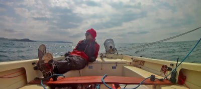
 Philip Lyne
On our last morning there was an eerie calm in Ralphs Bay—later we’d encounter some of the strongest winds we’d faced under sail.
Once used as a prisoner internment camp during World War I and then as a quarantine station during the 1918 influenza epidemic, Quarantine Bay today operates as a plant quarantine station with a small visitor center and basic campground. The campers set up on the gently sloping hillside, and before long we were tucking into a fine dinner of barbecued steak and sausages, salad, fruit salad, and ice cream—good food was definitely a perk of sailing in company.
The Tawe Nunnugah’s final push to Hobart
Our last full day of sailing dawned bright and clear, but the hours ahead were expected to be challenging. The distance from Quarantine Bay to a campsite at Rokeby, once a farming community and now an outer suburb of Hobart, was roughly 15 miles and the weather forecast was for very light northeasterly winds in the morning, building to gusts of up to 25 knots by lunchtime. By the afternoon the wind direction was expected to have shifted first to the east and then the southeast—typical of a summer day on the coast of southern Tasmania, but not great for us: the morning northeasterlies would be on the nose as we headed up the channel to the Derwent River.
 Tom Stevens
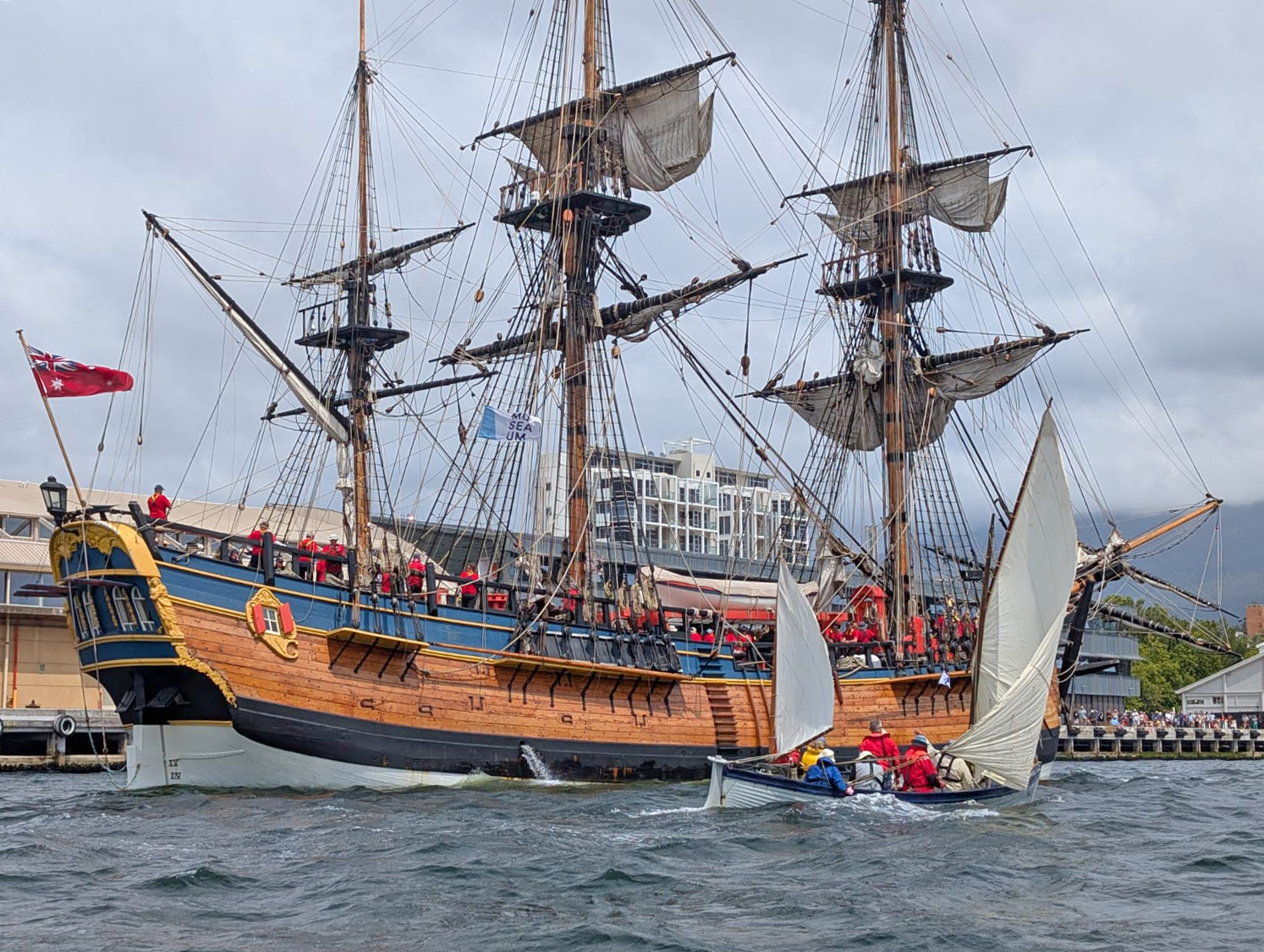
RUST NEVER SLEEPS fairly flew across the River Derwent on our final leg into Hobart. Anchored in the distance is the Australian-built replica of HM Bark ENDEAVOUR, Lieutenant Cook’s vessel of discovery.
Nevertheless, we had a date with a festival and were out of extra time. We made an early start, and by 7 a.m. most of the boats were underway in waters that were flat, calm, and glassy, just as forecast. Several of the smaller boats without motors requested a tow over the radio, and we took a line from Geoff Turnbull on STIRLING, a beautiful lapstrake dinghy, and set off with him in tow. About 1 1⁄2 miles beyond Quarantine Point, as the wind picked up, we both raised sail, cast off the towline, and waved our goodbyes. Once more we were headed out to the D’Entrecasteaux Channel.
The wind continued to rise. Sailing closehauled, we made our way up the channel, hugging the tree-lined west coast of North Bruny Island. We passed Rat Bay, home to a number of holiday homes and an occasional farm, and skirted the rocky shelf and khaki-colored bull kelp beds exposed by the morning’s low tide off Bligh Point, named after Captain William Bligh—governor of New South Wales from 1806 to 1808—who visited and anchored off Bruny Island several times. As we passed the hamlet at Dennes Point—a grassy headland just 20′ above sea level, and the northernmost tip of Bruny—we eased our sheets for a close reach, entered the River Derwent and headed east, for the western shore of the South Arm Peninsula. From there, as we once more turned north, still with a full set of sail, we hugged the coast for the next 4 miles, in an attempt to shelter from the strengthening northeasterly winds.
 Tom Stevens
ENDEAVOUR is a frequent visitor at the Australian Wooden Boat Festival in Hobart. The annual festival attracts boats large and small from far and wide. Regularly taking part is the fleet of boats taking part in the Living Boat Trust’s Tawe Nunnugah Raid. As the TN boats—such as the 27′ MONTY, an ex-naval whaler owned by the Living Boat Trust—join others arriving in Hobart, the waters in and around the festival become quite tight.
By the time we had cleared Gellibrand Point, the northernmost tip of the peninsula, the city of Hobart and its southern suburbs were clearly visible to the west. We furled our sails and motored directly into the headwind, a stiff 1′ chop on our bow, across Ralphs Bay to the Rokeby campsite. It was still only noon, but with Ralphs Bay fully exposed to the northeasterly wind now gusting up to 20 knots, it took some time to settle on a suitable anchor site as other boats continued to arrive and jockeyed for space. We anchored in 10′ of water, just 100 yards off the beach, packed up the boat, and went ashore—Andrew to pitch his tent, me to find my wife and sister.
 Tom Stevens
The TN25 fleet rafted up in Hobart for the festival. Being the only non-wooden boat of the fleet, RUST NEVER SLEEPS was docked away from the festivities at the Bellerive Yacht Club, but we made it back overland to the festival to join our fellow sailors in celebrating the end of a successful expedition.
Our arrival was perfectly timed: the following day, Hobart would celebrate the opening of the Australian Wooden Boat Festival, and the TN25 fleet was invited to participate in the official Parade of Sail and later to join the flotilla of wooden craft and tall ships on display at the Hobart docks. Being a fiberglass boat, RUST NEVER SLEEPS could not be included in the festival, so we made our way to the Bellerive Yacht Club for the weekend, going back into town to join our fellow Raiders later that afternoon. It had been an exceptional 10 days; I had made new friends, explored new sailing grounds, and developed an appreciation for extended cruising in a small boat. And throughout, RUST NEVER SLEEPS, regardless of her hull material, had done me proud.![]()
Jan Stephen Kent is the eldest of three children of Polish migrants who arrived in Australia in the early 1950s. Born and raised in Hobart, Tasmania, his love for the ocean came when he began surfing aged 14. He has surfed in Hawaii, Peru, Portugal, South Africa, and most of Australia. He and his wife have traveled extensively to the United States, Peru, Chile, Argentina, southern Africa, most of Europe, and parts of Asia, and have sailed off Croatia and Sardinia. Retiring at the end of 2023, he is still surfing, and messing around in boats has become his passion.
If you have an interesting story to tell about your adventures with a small boat, please email us a brief outline and a few photos.
Looking for more Australian boats? See…
Jan Stephen Kent’s Boat Profile, Cygnet 20, a trailer-sailer ideal for gunkholing
Ian Hamilton’s Boat Profile, First Mate, a Lillistone beach cruiser for sail, oars, and outboard
Nigel Sharpe’s Boat Profile, The Paroz Tender, a Queensland-built dinghy for oars, outboard, and towing

Good one, Jan. Thanks, that was fun to read!