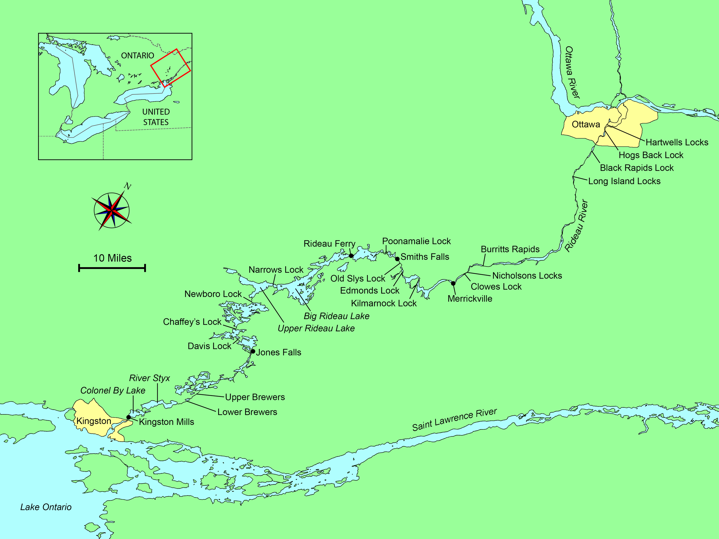
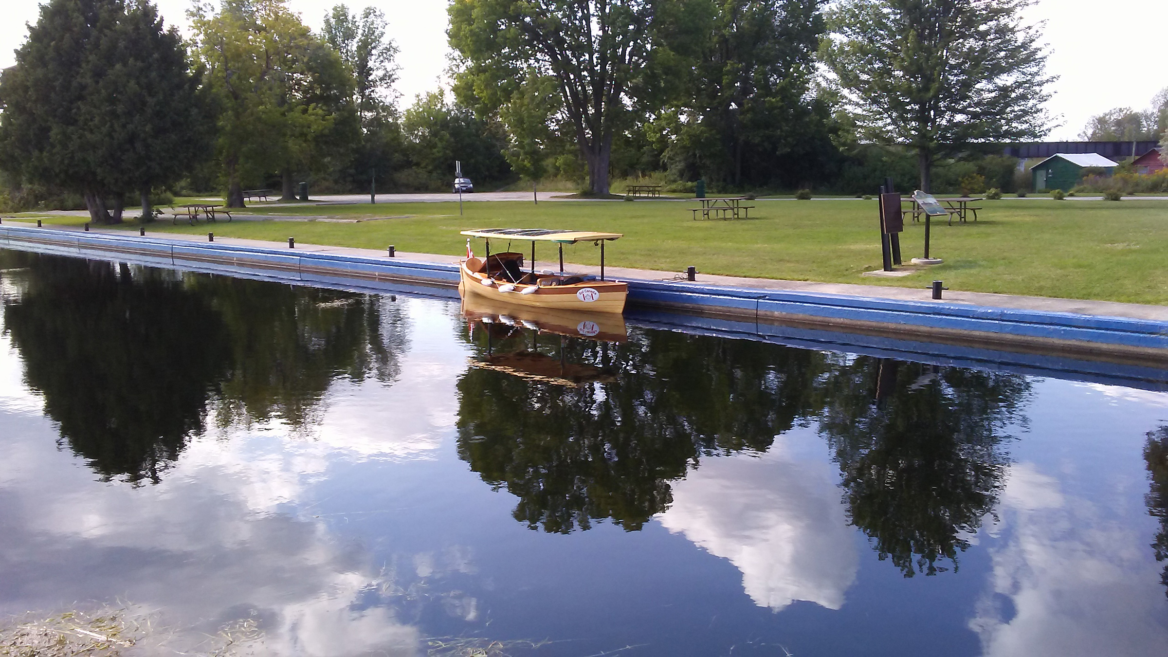
I stood on the old planked dock gazing out from the Kingston, Ontario, shore onto the Cataraqui River. The sky was clear and blue but for a few cumulus clouds, the late morning was a comfortable temperature for late August, and the light breeze made a few ripples on the river’s dark blue surface. The far shore seemed quite distant but was in fact less than a half-mile away. I could plainly see the trees lining the shore with the few apartment buildings peeking out. Not wall-to-wall buildings as you would expect in a city, but very rural with a wooded shoreline. To my right, downstream, I could see under the Kingston-LaSalle Causeway to the city harbor and beyond it out into Lake Ontario. I was at the south end of the Rideau Canal system, a 125-mile-long series of interconnecting lakes, rivers, locks, and hand-dug canals that has connected Lake Ontario to the capital city of Ottawa since 1832.
 Photographs by the author
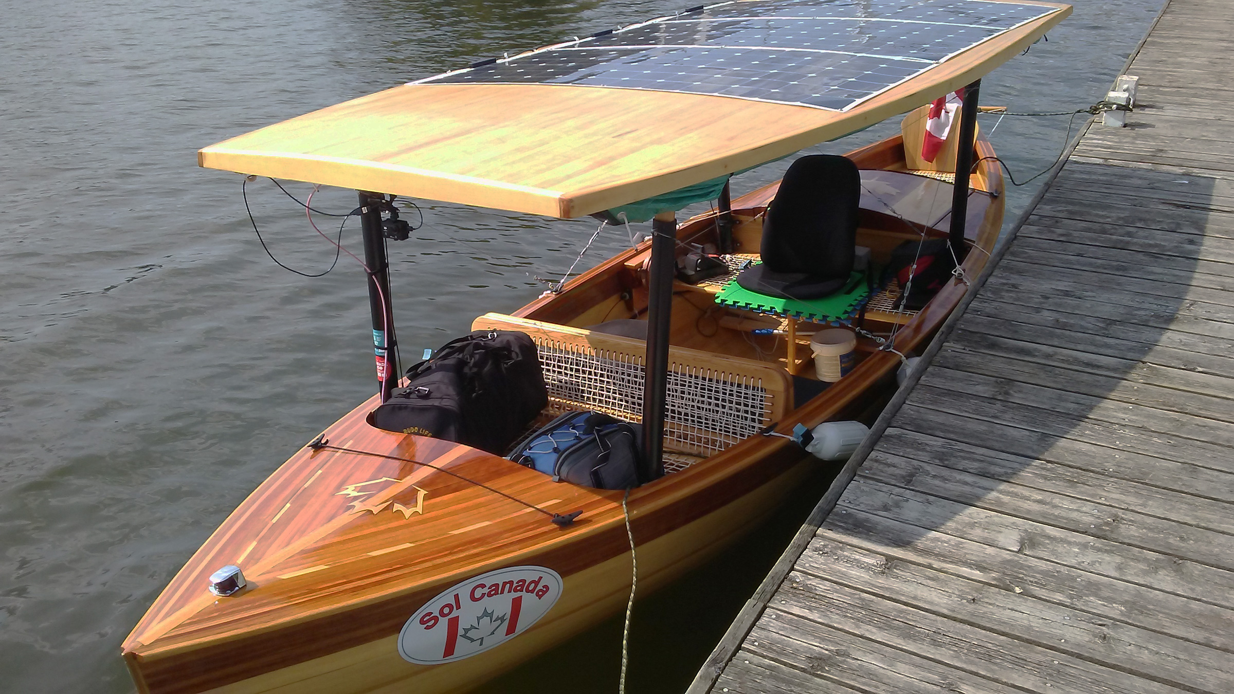
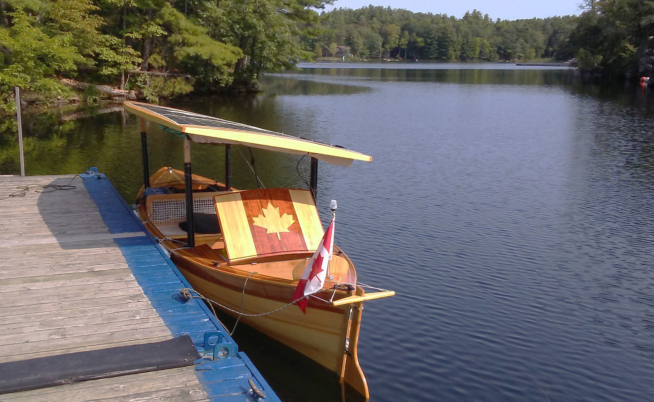
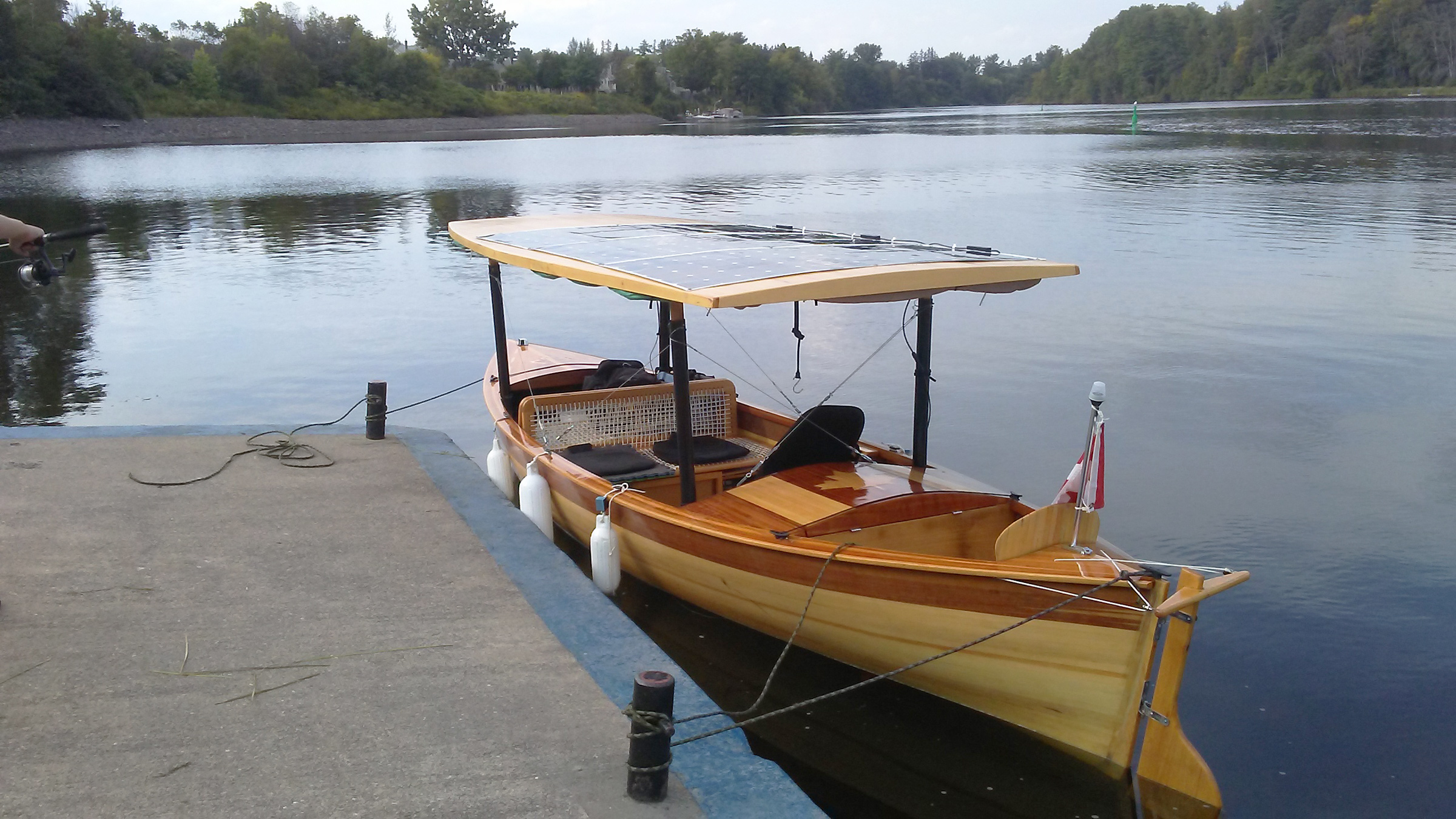
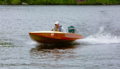
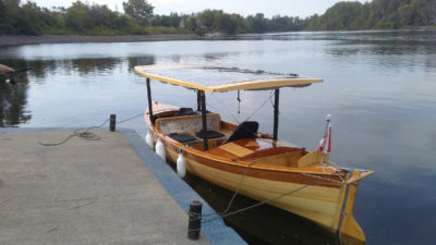
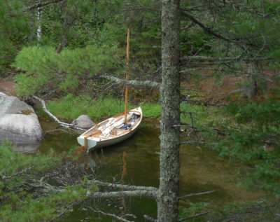
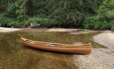
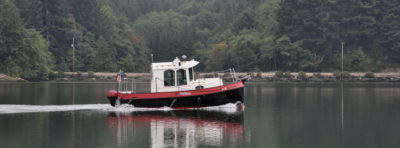
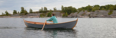
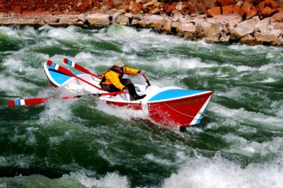
 It was getting late in the morning but SOL CANADA, the 18 1/2′ solar-powered cruiser I built, was finally ready to depart from the Kingston Marina’s dock, beginning my journey up the Rideau Canal system. I’d rely on the solar panels on the canopy to supply the only power I’d use to cover the 125 miles to Ottawa.
With SOL CANADA, my 18 1/2′ wooden, hand-built, solar-electric boat tied to the dock and now loaded with my supplies, I aimed to make it to Ottawa and back using only solar electric power. This has never been done before; at least that is the conclusion I arrived at from my research.
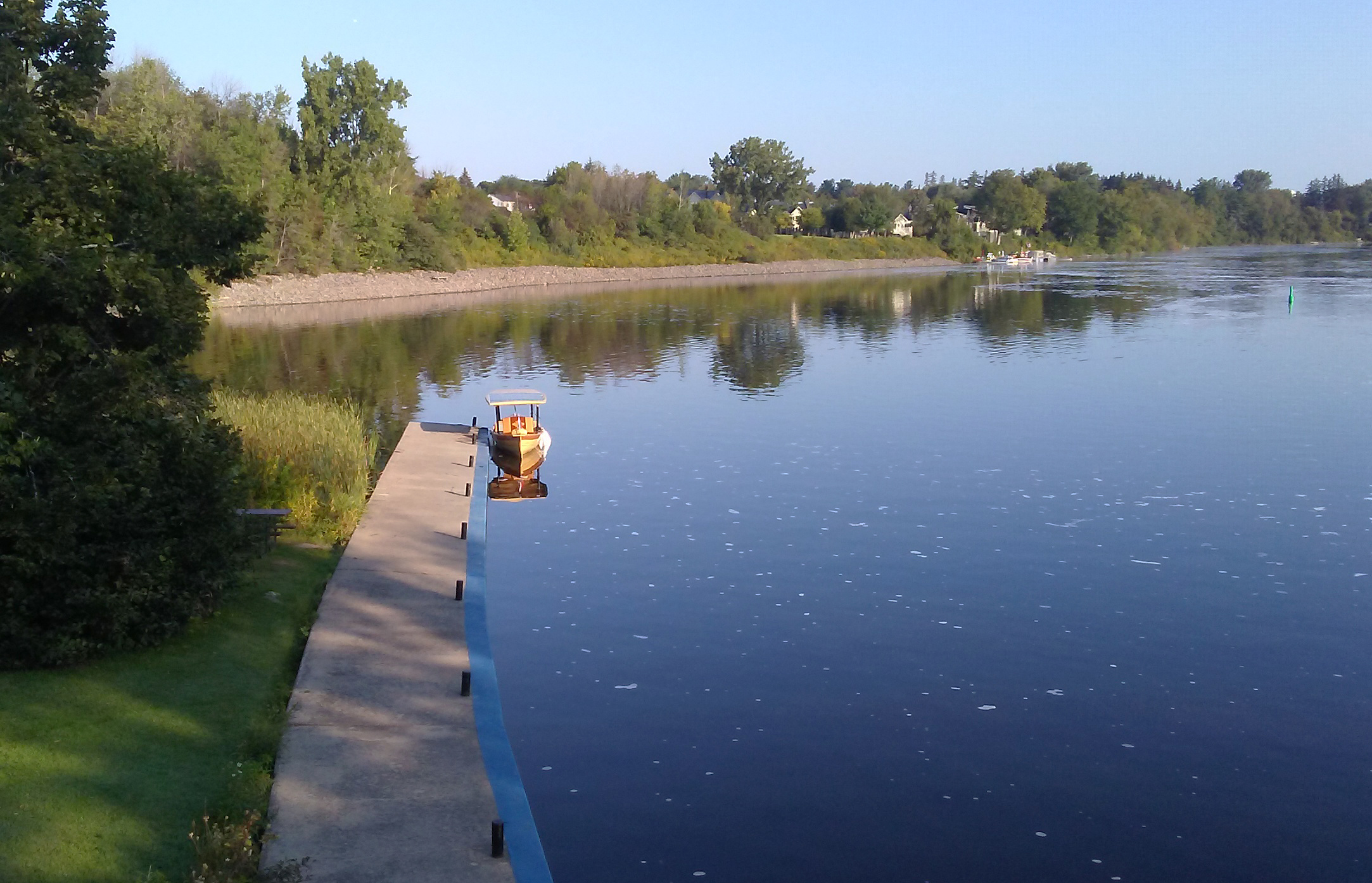
I shoved off at 11:30, made my way carefully out to the channel, passed by a few moored sailboats, and steered away from prop-fouling weed beds.
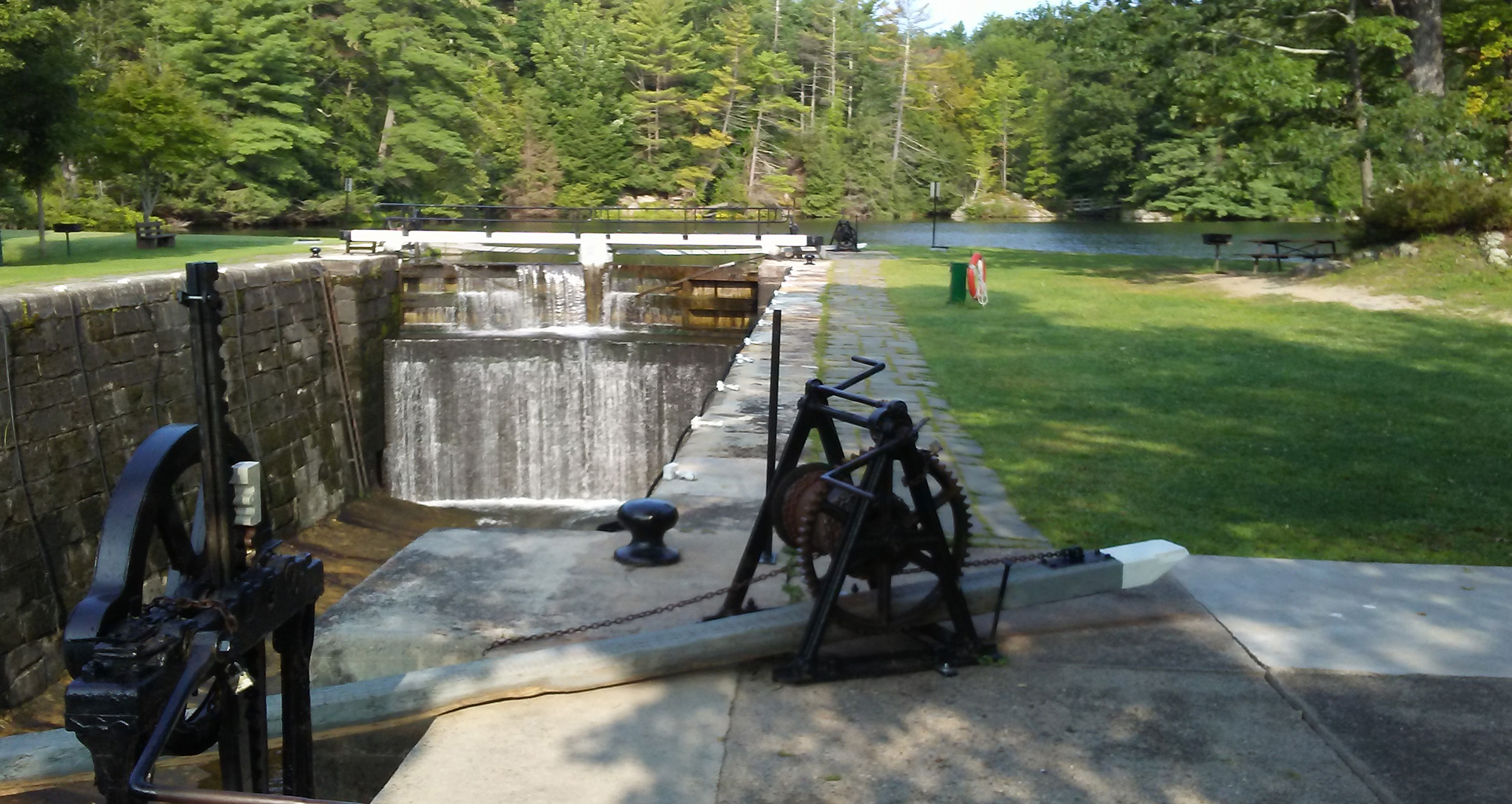
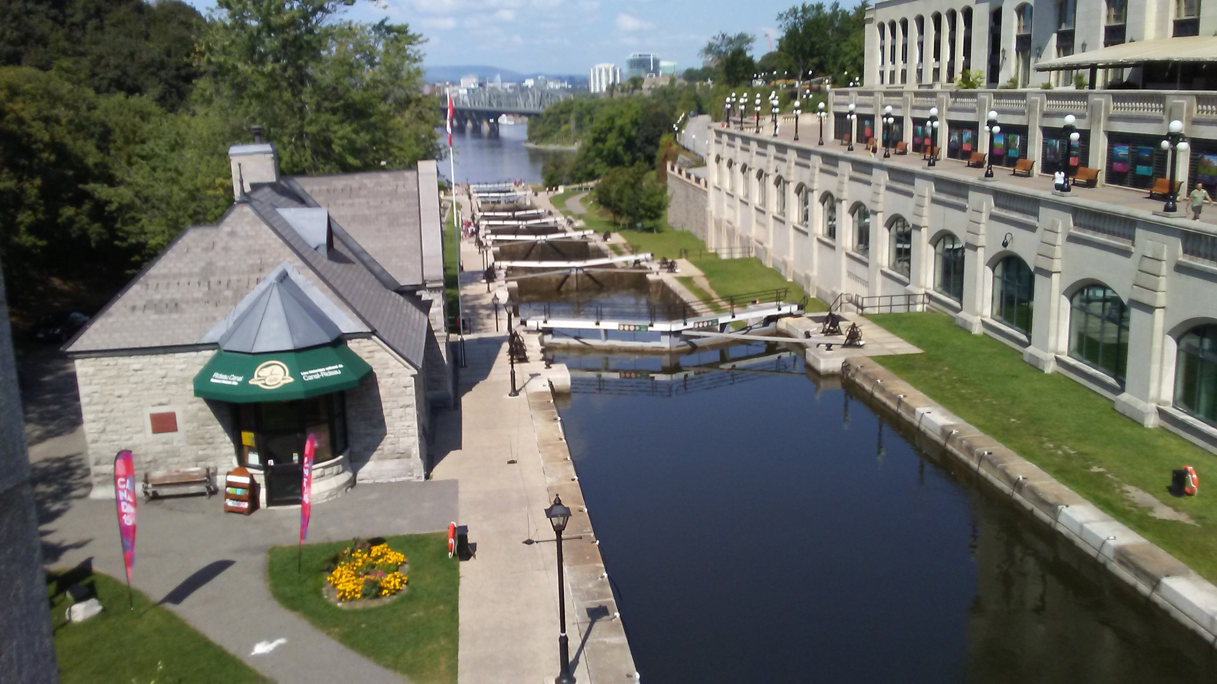
I made it into the channel and headed north. The current flowing against me slowed the boat to 3.7 miles per hour, a pace slower than I had planned for. The distance to the first lock was just under 5 miles upstream at Kingston Mills, and I could expect to arrive there in about an hour and a half. Within minutes of traveling up the channel, the city skyline vanished behind the riverside marshlands, acres of cattails, and grasses that are home to turtles, ducks, cormorants, Canada geese, mute swans, and seagulls. SOL CANADA was the only boat heading upstream. I soon passed under a busy overpass where thundering traffic disrupted the stillness. The banks grew higher and the river was soon flanked with high rocky shores covered with dense brush of pine and cedar. The river narrowed as if cutting through a gorge and stirred up algae, turning the water an emerald green. I followed a bend to the right and suddenly, over the bow, loomed the towering stone structure of the Kingston Mills Lock, like a medieval castle with round turrets of stone blocks flanking the lock gates. The flight of four locks would raise SOL CANADA 45′ in about an hour.
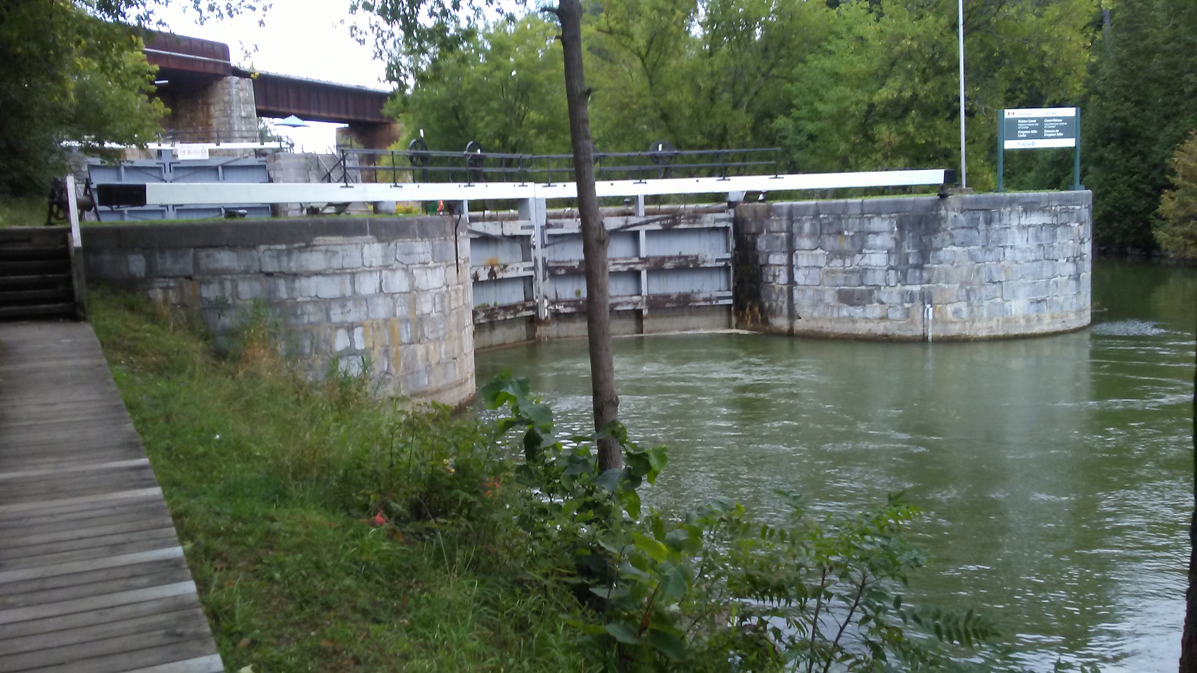
The Kingston Mills Lock on the downstream side is typical of all the locks on the Rideau with huge stone-block columns and wooden gates. This is how they were made in the 1830s and they’re still working almost two centuries later.
I did not have to wait very long before the lock gates opened to let a few downstream boats exit. A lock tender waved me in to take the left side of the lock. I motored slowly forward and looped the painter around one of the vertical mooring cables. The grayed walls were chipped in some places and covered in slippery algae in others, and in the mortared seams between the blocks grew tufts of weeds and moss. As I waited in shade of the walls, the aroma of the lock reminded me of an old damp, musty basement.

Ascending in the locks was often a turbulent ride as water poured in from upstream. When I passed the apex of the Rideau and entered the descending locks, the water would be quite still as it drained.
The lock tenders cranked open the sluice valve and water rushed in, bouncing my small boat around. I used my boathook to push away from the walls to keep the canopy and the solar panels that covered it from being damaged. I slipped into the sunshine as the water level rose and soon the gates slowly opened as the tenders cranked the large winch handles by hand. SOL CANADA was the only boat in the lock, so I proceeded alone into the second chamber to repeat the process and then moved to the third chamber. I crossed a 75-yard-wide mill pond before entering the fourth lock.
After I motored out of the final lock, I stopped at the wood-planked mooring dock to get out and stretch my legs. The sky was still mostly clear but the clouds were starting to creep in from the horizon and would eventually affect the output of the solar panels.
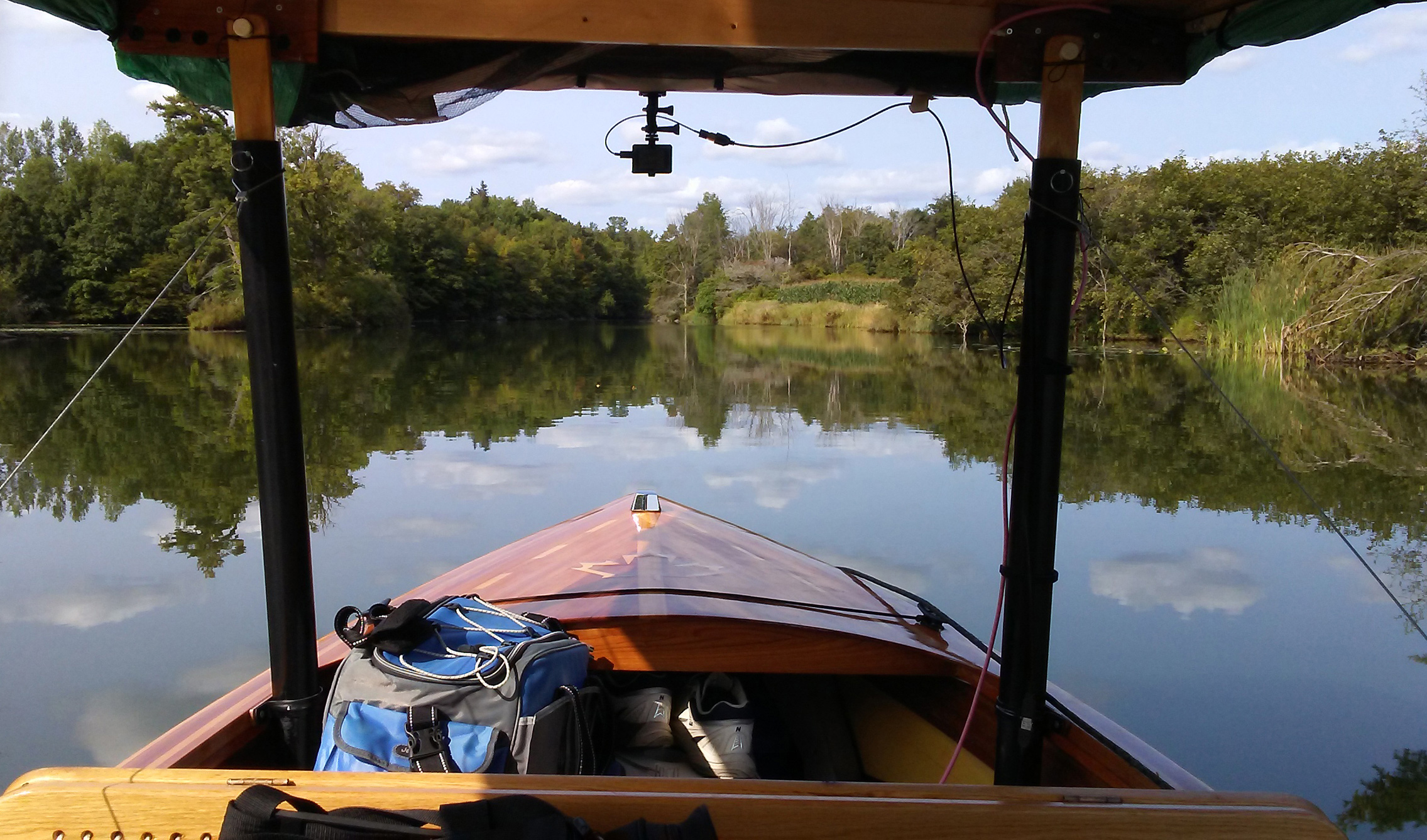
The river widened into Colonel By Lake, which stretched 3 miles north where it again narrowed through a dog-leg channel into the River Styx, another wide stretch of water where the shores were lined by marshes and dotted with widely scattered farm buildings. After covering 5 miles at cruising speed, I steered SOL CANADA into a 50-yard-wide riverway that gently weaves through farmland and marsh for more than a mile leading to the Lower Brewers Lock. On the right bank, a great blue heron waded along the shore on stilt-like legs, intent on the water, and ready to strike at any small fish with its long-pointed beak. How catching a fish could be possible was beyond me as the water here was a very murky bright green and nothing below the surface was visible.
Between Lower Brewers Lock and Upper Brewers Locks the canal enters and meanders through peaceful wetlands where only the wildlife broke the stillness. The water here was bright green.
On both sides of the stream, maple and willow trees arched their branches over the banks. There were no other boats at Lower Brewers when I arrived, and the lock gates opened almost as if by magic. Ten minutes later, SOL CANADA had gained another 13′ of elevation.
It was 4 p.m. I had planned to make it to Jones Falls by day’s end, more than 12 miles away upstream, but first I would have a half hour’s journey of 1-3/4 miles to Upper Brewers Locks, which has two chambers to pass through. I could have stayed the night at Upper Brewers, but that would have put me behind on my schedule. My average speed seemed to have settled on about 4.5 miles per hour, very good for SOL CANADA. The sun had stayed out most of the time, and the solar panels had held the charge on my battery bank at 95 percent; I was in good shape to continue.
Upon reaching Upper Brewers Locks, the gates again were open for me and I was able to pass right in without stopping. The Parks Canada staffers always monitor the traffic and ask you how far you will be going so they can notify the next lock about boats in transit.
SOL CANADA had been performing fairly well, but about once an hour the motor would just stop. I could get it going again by putting the throttle neutral for a few seconds and then I could put it back in gear. This was happening more frequently, and by the time I left the lock, it was occurring about every 10 to 15 minutes. The 11-mile run to Jones Falls should take two hours and 20 minutes, but the delays caused by the motor would add to that. I decided to push on. After 4 p.m. in late August, the solar production diminishes quickly, so I’d have to rely on the batteries as the day wore on.
The route took me through three lakes—Cranberry, Little Cranberry, and Whitefish—and the meandering channels between them. The landscape was marked with bare granite outcroppings and dense forests of cedar and pine. Cottages took the place of farmhouses, and the water was clear—a deep, dark blue.
The intermittent motor outages continued until I reached Jones Falls at 7 p.m., 40 minutes behind schedule and too late to be let into the locks.
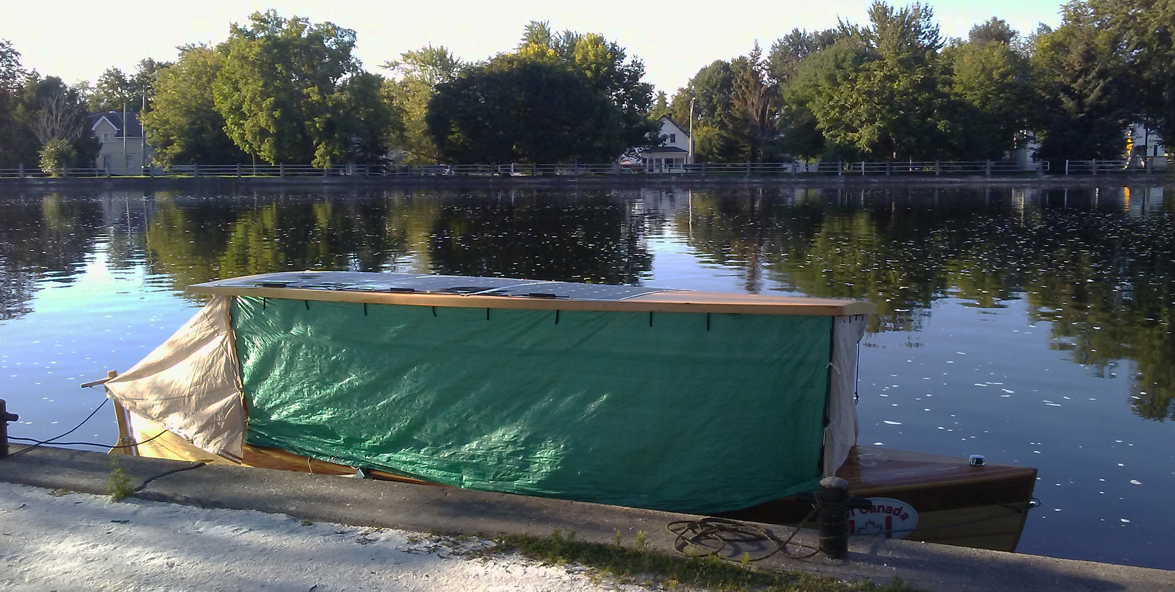
To keep wind, rain, and prying eyes out I enclose the cockpit with tarps. During the day, they’re rolled up and secured to the canopy.
I moored the boat at the downstream wharf and got my boat into camping mode. I rolled canvas panels down from the perimeter of the canopy and fastened them to the gunwale. I folded the seats down to make the sleeping platform and set my inflated air mattress and sleeping bag on it. For dinner, I heated up some spaghetti for a quick bite to eat.
Before turning in, I walked through the locks to see what the Rideau Canal had in store for me in the morning. Jones Falls is a four-lock flight secluded from any towns but it has a resort a hundred yards down from the lock. I could have walked across the boardwalk and enjoyed a nice meal, but I was thinking about the motor, concerned that I could not continue the trip if it continued to cut out. I phoned my son-in-law to see if he would be available to drive my trailer to me if I decided to terminate the trip. While talking with him, I thought perhaps it was a thermal issue and that I would try traveling the following day with the hatch open to allow for better cooling. We decided that I would at least continue for one more day after I had a good night’s sleep.
Early in the morning of the second day, I waited for the Jones Falls lock tenders to begin their day’s work. Beyond the upper gate is a mill pond I’d cross to get to the final lock in the flight of four.
The night sky was starry but the air was very cold, and I woke several times shivering. With my jacket draped over the sleeping bag, I slept okay but was wide awake and up by about 6:30 a.m. The sky was clear and blue and a morning mist rolled across the 100-yard-wide bay at the base of the locks. The water was mirror-like, adding symmetry to the beautiful patterns of white and green made by the pale stone blocks powerhouse at the base of the dam and the wooded banks that surrounded them.
The previous day I had run the battery bank down at 80 percent, which concerned me as the boat’s lead-acid batteries shouldn’t ever carry less than half of a full charge. This was my first strictly solar-powered trip, and I was not sure if I was being too conservative or not. My goal was to have the battery bank back to near 100 percent at the end of each day to avoid depleting the batteries.
At the mooring dock just beyond the final Jones Falls lock, I decided to give the boat a couple of hours of sunshine and tilted the canopy to more quickly charge the batteries. I had depleted them to an 80-percent state of charge.
At 9 a.m. the lock staff arrived and opened the first chamber for me. I was once again the only boat going through, which made going through all four chambers of the first flight a quick process. I was through to the mooring dock in about 45 minutes. I moored at the upstream dock to boost the charge on the batteries. To maximize the charging, I angled the canopy on its adjustable posts to face the sun. While the boat was sitting there in the bright morning sun, I crossed the lock on the white painted walkway on top of the gates. Peering over the black painted steel railing and looking down into the lock basin made me a bit dizzy.
Up the hilly pathway was a small stone building approximately 30′ by 20′. The blocks that composed the walls were of assorted sizes and colors—mostly variations of beige and gray, others rusty red. Two windows, each composed of 24 small panes of glass, flanked the entry to this restored lockmaster’s home. Inside were heavy wooden shutters that could close off the windows and small rectangular slotted holes in the walls were gunports the first British lockmasters and staff could use to defend the house if Americans were to attack. The Rideau Canal was built by the British Navy after the War of 1812 as a military route to bypass the Saint Lawrence in case another conflict with the Americans occurred.
The footpath crossed a weir used to divert excess water to keep it from overwhelming the dam downstream. Water tumbled down in a thundering torrent of foam.
When I returned to the boat, I re-leveled the canopy and checked the state of charge. It was now at 90 percent. That was enough to allow me to continue cruising, though I’d have to travel at a reduced speed of 3 miles per hour to ease the draw on the batteries. The solar panels could then supply the power to the motor while trickle charging the battery bank.
 Roger Siebert
.
Working my way through the curving waterways that connected pond-like lakes I had to round the bends cautiously, keeping watch for oncoming traffic in the very narrow channels. This went on for about 3/4 mile before opening up to a series of lakes, channels, and locks. During the afternoon, bright sunshine fell upon the solar cells, but a haze of overcast moved across the sky as I made my way through Davies, Chaffey’s, and Newboro locks. I kept the motor hatch half open to allow a good amount of airflow to the motorwell, and that helped keep the motor running. It shut down only twice.
The lakes had high granite shores and forests of large maple and white pine trees. The dark blue water was clean, deep, and cool. Cottages and docks were scattered along the shores and on the islands and there was considerably more boat traffic. At one point I was swarmed by fishing boats flying by flat out, racing back for a fishing derby weigh-in. Even at my decidedly slower pace I was making good progress along the circuitous 18 miles of the route to the Narrows Lock.
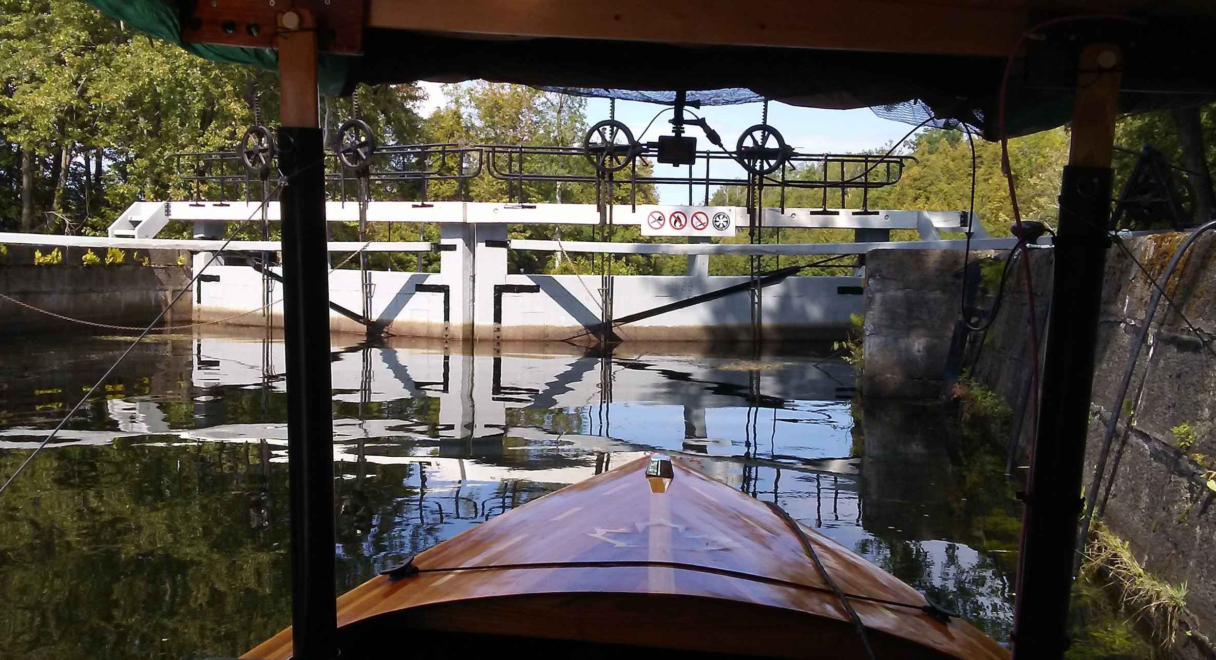
The Narrows joins Upper Rideau Lake with its much larger sister, Big Rideau Lake. Upper Rideau is the summit of the Rideau Canal system, so the lock would be the start of the 275′ descent to the Ottawa River. A causeway at the Narrows carries a backcountry highway to a swing bridge that crosses the locks. The bridge is low, so before boats can pass though the lock, a gate with flashing lights blocks traffic while the bridge is raised and the lock gates are opened.
By the time I passed through the lock after a drop of just 3′, it was getting close to 6 p.m., so I swung around to the back side of the long extended wooden pier and moored about 40′ behind a large yacht. In the protected cove between the pier and the causeway, I’d have good shelter from the wind. A picnic table on the pier right next to the boat was where I settled in for dinner.
As morning broke I climbed out onto the dock and found Big Rideau Lake perfectly still, with mist hanging in the air right next to the water. The trees were separated from their mirror images by an indistinct white boundary that looked like a smudged line of chalk.

I approached the bridge at Rideau Ferry, which separates Big Rideau Lake from Lower Rideau Lake. The name of the place recalls the ferryboat that crossed the channel before the bridge was built.
Big Rideau is the largest of the lakes on the canal system. It is 13 miles long and its perimeter is dotted with as many elegant homes as humble cottages. I got off to a late start and made my way up the lake, following a course just 100′ from the west shore in case the wind came up and I needed a lee. The lake stayed calm, barely rippled, except by the wakes of boats that appeared as the morning wore on. I reached the top of Big Rideau Lake where Rideau Ferry, a 150-yard-wide channel, divided Big Rideau from Lower Rideau Lake. The gap is spanned by a 26’-tall cement bridge, high enough to let boats pass beneath it.
Crossing under the bridge I checked my batteries’ charge. They were at 94 percent, so even with the skies becoming more overcast I was in a good position to cross Lower Rideau Lake to a narrow winding section of the Rideau River.
After passing through Lower Rideau Lake, I entered the Poonamalie Lock and was now headed downstream. The experience in the descending locks was quite different and much easier. Draining the lock and descending is no more turbulent than pulling the plug in a bath tub.
The low banks were dense with cedar and brush, the water was glass calm; the ride was so peaceful, unspoiled by the quiet running of my electric motor. After making my way along a channel that took me through the Poonamalie Lock, the waterway opened to wide marshlands. Around a third bend in the river I saw an old bascule railway bridge, abandoned and left in a permanent 45-degree angle. It marked the entrance to the locks at Smith Falls. The first lock lowered SOL CANADA into a large manicured basin in the middle of a park in the heart of the town. I passed through to the second lock and moored on the downriver side so I could leave at my own leisure in the morning rather than wait for the lock. I walked into town for a restaurant meal.
At the first lock at the town of Smith Falls, I had to wait for a few boats before we entered the lock. The lock tenders are always aware of what boats should be approaching and will wait until everyone is at the lock before opening it.
I left Smith Falls early the next morning. I had been traveling for three days and had passed the halfway point. I had my battery management down pat and knew how far I could travel given the amount of sunshine a day would provide. This waterway weaved through low terrain with large marshy bays thick with cattails. I was careful to remain in the channel as the river and bays were clogged with weeds.
The day was warm and sunny and I would have seven locks to go through to travel the 20 miles to Burritt’s Rapids. The current was in my favor and SOL CANADA made 5 mph over the bottom as my battery bank gained enough charge to reach and stay at 100 percent while underway. I covered the first 6 miles with ease and passed through Old Sly, Edmonds, and Kilmarnock locks. Rarely did I see another boat. There were no cottages; the unspoiled terrain was inhabited instead by turtles, ducks, and geese.
I arrived at a very narrow channel that led me into the first of three locks in the town of Merrickville. The bright sun made the buildings around the lock glisten. Just yards away stood the Merrickville United Church. Opened in 1890, it is built of rough-hewn blocks of limestone and has a square bell tower with narrow arch-capped windows. Beyond the church were three-story commercial buildings all made of radiant limestone.
The lock gates closed, we descended, and as the downstream gates opened a steel swing bridge in front of us slowly opened as all the cars driving to and from town waited. The group of boats proceeded to a second and third lock, both flanked by trees and well-manicured lawn. When the gate of the last lock opened, I put the power to the motor and jumped out in front of the pack of boats to get a bit of a lead on the way to the next lock, Clowes, 2 miles downstream. The lockmaster there would wait for all the boats to gather before closing the gates, and I did not want to be the straggler who kept everyone waiting. The other boats all soon overtook me and the wakes of a few, hitting the port quarter, tossed SOL CANADA around, forcing me to pull back on the throttle. Even so, I was not too late to enter the lock.
A short distance past Clowes was a half-mile of channel that was hand dug, mostly through limestone, over 187 years ago. The passageway was narrow—at places only 40′ across—and bordered on the west by a line of limestone blocks arranged to create a level walkway.
Three miles downstream, the river splits with two channels, creating a long, narrow island. The right channel led me pass the town of Burritts Rapids, which sits in the broad middle of the island. After passing through the lock at the tail end of the island, I secured SOL CANADA for the night to a long dock away from the main channel.
The following morning was looking to be a good day for keeping the batteries charged, but I had some concerns that wisps of clouds might cover the sun later in the day. I had to travel 25 miles to get to the next lock and SOL CANADA had never traveled that far in one day. If bad weather closed in, I could be in a bit of a pickle if I had to stop for the night short of the lock.
It was a beautiful morning at Black Rapids Lock as I got ready for a final push to reach downtown Ottawa. While this area is within the city limits of Ottawa, it is quite pastoral.
I motored through about 7 miles of the Rideau River hemmed in by farmlands; beyond them, the suburbs of Ottawa crowded the banks. I cruised under a couple of noisy, heavily trafficked bridges and passed several marinas before I reached Long Island’s flight of three locks. The weather had held and remained mostly sunny, so I was thrilled to see the batteries at 94 percent. It was still early enough in the day to push another 5 miles to Black Rapids. The river was lined with homes and cottages and busy with boat traffic.
I finished the fifth day at the downstream side of Black Rapids Lock. This is a popular spot for fishermen and I had to anticipate having company in the morning and be ready to cast off to get out of their way.
I passed through the Black Rapids Lock and tied up for the evening. I had traveled 30 miles in one day on solar-electric power, the farthest I have ever gone, and my battery bank was still at 94 percent.
I woke to a beautiful morning, excited to make my final push to Ottawa. The air was a bit cool, but there was neither a cloud in the sky nor a breeze on the water.
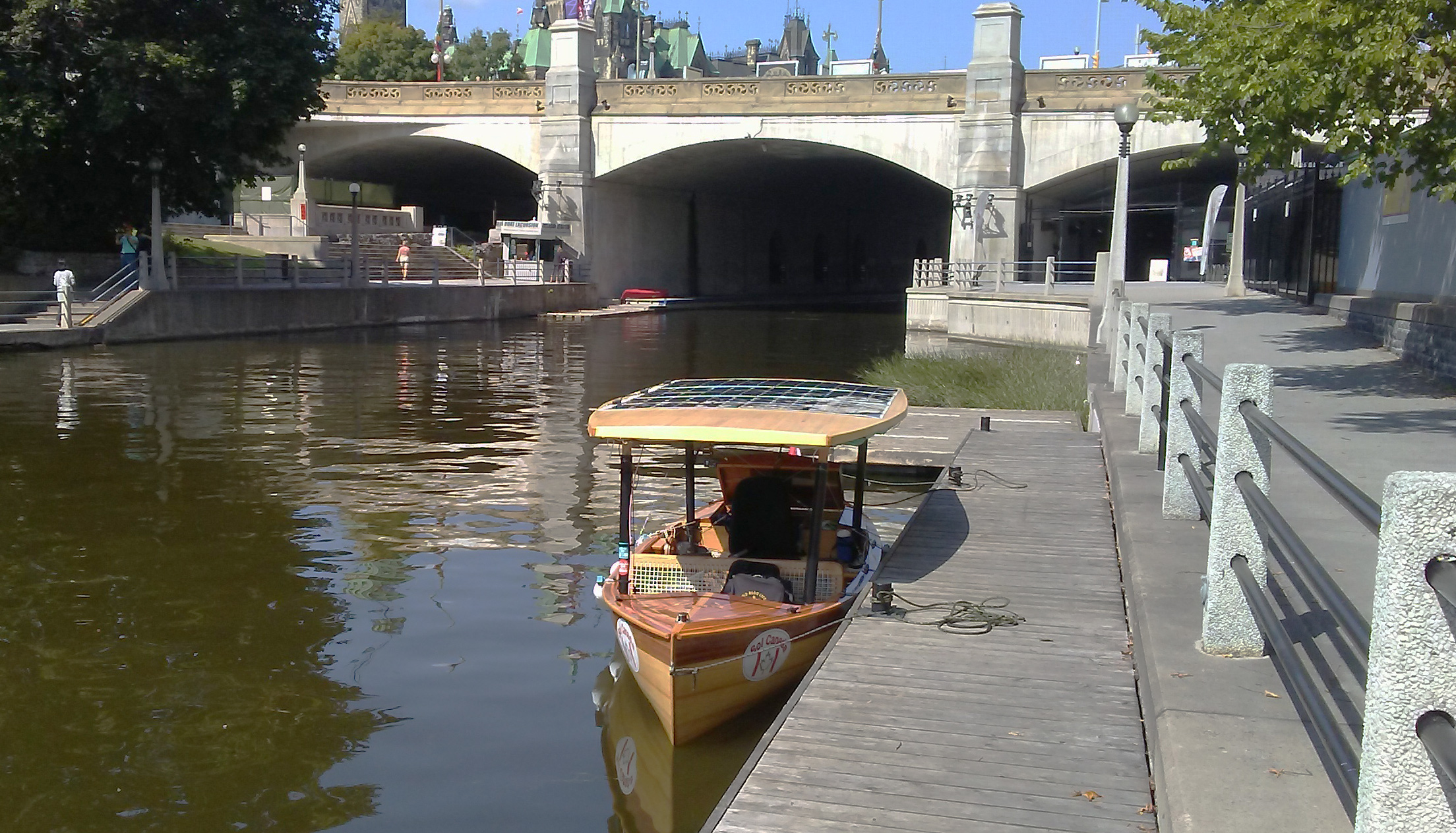
The dock in downtown Ottawa was my final destination of the trip. Through the dark passage under the Wellington Street bridge is the top lock of the flight of eight locks that descends to the Ottawa River. The intricate building looming above the bridge is the East Block, one of the three buildings of the Canadian Parliament.
I started downriver, passing a rock berm all along the shore for a few hundred feet and then a mix of trees and homes so well blended that it seemed more country than city. As I approached Hogs Back Lock I passed Mooney’s Bay, usually crowded with beachgoers, swimmers and rowers, but there was not a soul to be seen this chilly day. At the north end of the bay the river splits. To the left is the lock at the entrance to the canal to downtown Ottawa, and on the right the Rideau River parts company to tumble over the dam above Hogs Back Falls on its final descent to the Ottawa River. A mile downstream along the canal, beyond a row of mansions, I passed through Hartwells Lock adjacent to the modern blocky buildings of Carleton University.
The canal narrowed to about 150′—all along the banks it was well-kept park land, bike paths, and busy streets—then made an abrupt 90-degree left turn and narrowed to 90′. Down this straight 3/4-mile-long final stretch I could see the castle-like Chateau Laurier hotel and the limestone buildings of Parliament with their green-patinaed copper roofs. I came to my final moorage, a pier running along the canal beneath a row of large ornamental street lights. Just a short distance beyond were the final eight locks that drop 79′ to the Ottawa River. It could take at least 1-1/2 hours to travel the last 1,000′ of the Rideau Canal system, so I made my final destination the top of the locks and counted that as the first ever 100-percent solar-powered voyage from Kingston to Ottawa. I walked the short quarter mile to the Parliament building. It was lunch hour and the lawn there was full of people in a yoga class.
The descent to the Ottawa River, seen in the distance, traverses the eight locks of the Ottawa flight and can take hours, so I decided not to go down them.
After lunch I was back to my boat. I had a schedule to keep, and that was to start the journey back along the Rideau Canal to Kingston where I had started six days ago. The trip from Ottawa to Kingston by solar-electric boat had never been done either, and I intended to be the first.![]()
Phil Boyer retired in 2017 after working 38 years in R&D in the telecommunications industry. He now keeps busy teaching karate at two local clubs and building boats. He has been around boats his whole life, starting with paddling as a kid. At age 11 he built a sailing pram with a bit of help from his father. In 2006 he began building solo canoes and now has four of them, featured in the August 2019 issue. Phil’s interest turned to building SOL CANADA, his solar-electric boat, in 2015. His next build will be a solar-electric version of the Power Cat he read about in the March 2016 issue of Small Boats Magazine.
If you have an interesting story to tell about your adventures with a small boat, please email us a brief outline and a few photos.
A very inspirational story!! I have been toying with the idea of building a solar-powered boat for years. Thank you so much for sharing this with us all.
Phil,
Thank you for sharing this trip with us. I am a home-bound ex-skipper and thoroughly enjoyed traveling along with you on this journey.
Jim Fischer
Thank you for enjoying the article. I was hoping that readers would get to feel at least some of the excitement of going on an adventure.
Phil Boyer
Phil,
Thank you for this story, what a great trip! Having spent many years in diesel-electric submarines I can fully understand the challenges of managing lead-acid batteries with only the sun available for charging during the day. The pressure of a schedule makes it difficult too. Well done for making the trip and writing this article.
You’re welcome, Sid. I had a fantastic time. I plan on repeating the trip next year in a new catamaran I am building. I can hardly wait.
Thank you for the story and photos of your voyage, Phil. As a Canadian reader, I can’t help but note the close resemblance of your boat’s distinctive hull shape to that of the classic Muskoka disappearing propeller boat, or Dispro. And when you mention that, “Once an hour the motor would stop for no reason,” well, that also echoes the behaviour of the occasionally cranky hundred-year-old gasoline power plants of the cherished original Dispros. Plus ca change …
Congratulations on an innovative boatbuilding project and ambitious test run.
Hi John, sorry for the late reply. The hull design is from the Dippy. I am actually a member of the Dispro Users Association. I grew up in the summers on Lake Muskoka and remember Dippies being on the Lake.
I would rather build it then go alone like you did.
Phil: Thank you for this inspiring article! The Rideau has always been on my list. What time of year did you take this cruise? My folks have done the Rideau several times and I recall them talking of heavy boat traffic and congested locks. You certainly didn’t have that experience. You did mention “brisk mornings” so I’m guessing late Spring? Thanks again!
You may have missed the bit in the first paragraph that mentioned “late August,” so the brisk mornings were signs of autumn’s approach.
Ed.
Thanks for the fascinating account! Can you give us some details on your boat’s configuration? Wattage of your panels, voltage and Amp hours of your battery bank, and what sort of motor was used?
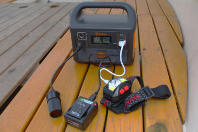
Hi Neil, the boat is 18′ and is a displacement hull. I use a 24-volt 220-amp hour lead-acid battery bank (golf-cart batteries). The motor is a Torqeedo 2.0, which is 5HP. The panels total 860 watts and are flexible so they weigh about 8 lbs each.
With 860 watts you never get to that level as you are never at perfect right angles to the sun plus atmospheric conditions. For calculating the requirement for the day I use 50% which is usually a good average for the day.
Thanks for those details, Phil. Could you also clarify what you mean by 50% in your solar calculations? I’m about to add a Torqeedo 1103 C (3 hp) to my modified 20’ Whitehall for extended camp/fish/cruising in N Canada. I’m also estimating 50% of nameplate Watts but then reducing that further across a flattened Bell curve to account for lower solar intensity in the morning and late afternoon. I’ve used a 3.5-hp gas outboard on the Whitehall, so I’m confident the 1103 C will suffice. I only have space for 310 W of solar, however, so the Wh estimates are important.
Thanks,
Tim
Thank you for including us in your wonderful trip! A few years ago, three other women and I rowed our racing sculls from just above the Kingston Mills Lock to Ottawa. We traveled at about the same speed as you, bypassing Big Rideau Lake. On the first day, a herd of curious cows wandered to the water’s edge, a contrast from the boating traffic near Ottawa. The lock experience was quite an adventure – most lock masters had never seen boats like ours. It took a bit to convince them that it was necessary for us to sit in the middle of each lock with oars in the water to keep from capsizing. Unfortunately the July sun took its toll and we had to stop just south of Ottawa. You’ve inspired me to go back and finish the last few miles!
Hi Karen,
I love the Rideau and especially the peaceful areas from Kingston Mills to Black Rapids. I will be tackling it again in 2021.
Your motor was stopping intermittently until you opened up the hatch. I assume that the motor was overheating and this corrected the problem. Would you recommend adding vents or other means to aid in cooling the motor?
Thoroughly enjoyed your narrative of the journey and the equipment information. Very interested in electric small craft for touring U.S. lakes, rivers. Have used small trolling motors on canoe and kayak, and building a 12′ skiff in Florida that I’ll electrify. Considering lithium batteries next. Did see the Rideau canal in Ottawa during a short holiday there years back. Have a great safe trip in 2021.
Thank you
Wonderful story, Phil. Good luck with your cat build!
Very interesting story. In the late ‘80s I built a pedal-powered launch. I later converted the propulsion to a modified trolling motor. I still have the wooden hull I built to serve as a plug to make a fiberglass hull mold and have rigged it with a 78 sq. ft. lug sail. I sail most days in the summer off Brighton, Ontario.