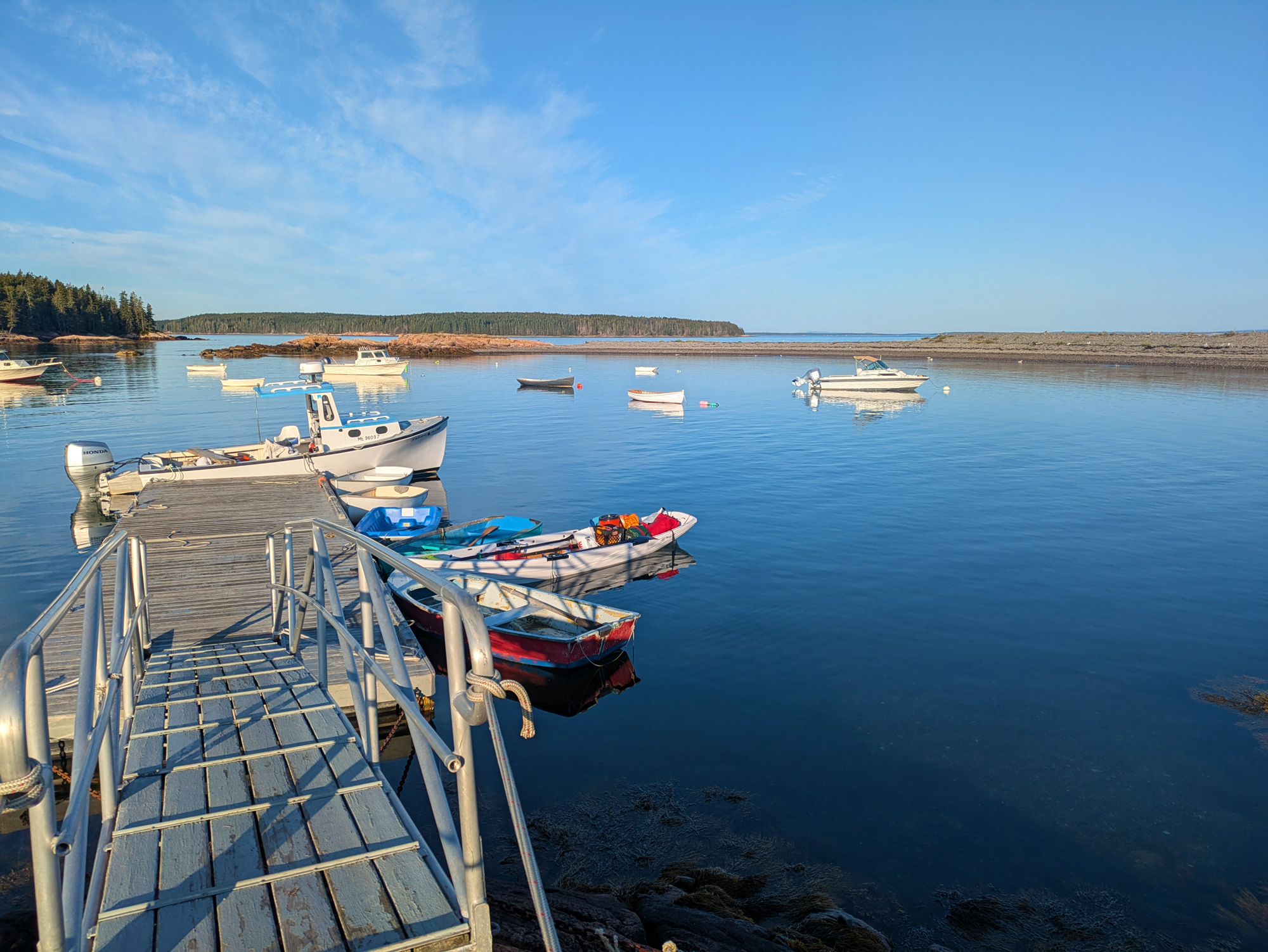
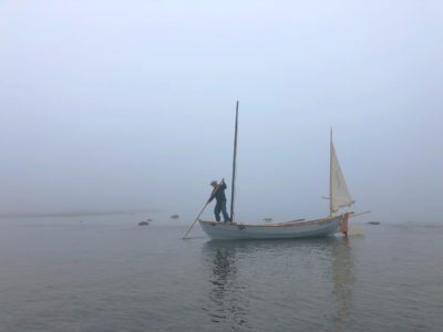
Looking out over Bass Harbor, Maine, from the Bernard launch ramp I could see riffles across the water, and the southerly breeze on my cheek felt consistent with the forecast 10 knots. To the north, low, broken cumulus clouds scudded over the high terrain of Mount Desert Island (MDI); to the south, the view was obscured by dozens of lobsterboats both moored and underway. It was late August. Even in summer, working lobsterboats moored in Bass Harbor vastly outnumber the pleasure craft.
The previous day, I had been forced to postpone my voyage due to high winds, but today the weather looked promising. The sun cut through the clouds, the temperature was comfortably cool, and the air smelled of seaweed with the hint of fishiness one often finds in the working harbors of Maine. As I launched AURELIUS, my Tango 17, a sliding-seat Whitehall, down Bernard’s narrow public boat ramp, the lobstermen unloading their catch at the town wharf paid me no mind. Indeed, as I pushed off, right at noon, and carefully navigated through the warren of moored boats, gear-laden mid-harbor floats, and slow-moving lobsterboats, I was barely noticed.
 Photographs by the author
Bass Harbor on Mount Desert Island (MDI) is home to more commercial fishing boats than leisure craft. In the distance can be seen the high summits of MDI.
My plan was to explore the four islands directly south of Bass Harbor, with the possibility of then going farther south to the environs of Swans Island, the nearest island with a year-round community south of MDI. My first waypoint was Great Gott Island, about 2 1⁄2 miles away. As I rowed toward Bass Harbor Head, the harbor widened from barely 300 yards across to more than a mile. The moorings thinned out as I made my way past the large dock of the Maine state ferry to Swans Island and Frenchboro. The breeze picked up a few knots, and by the time I reached the green can at the harbor’s mouth, I was rowing into a light chop from the south. I stayed close to the bluff on the east side of the harbor, thinking I would be clear of boat traffic and that it would afford me the most direct route to Great Gott. It was my first mistake—it was, indeed, the shortest distance between Bass Harbor Head and Great Gott, less than 1 nautical mile, but it took me almost directly over the Bass Harbor Bar. As I realized my error, I weighed my options: I’d heard that the bar could be troublesome, but I was approaching at mid-tide, which according to the chart, would mean a depth of about 45′ to 50′ over the bar. Surely that would be OK. I continued on my way. Within minutes the light chop had become a confused sea with closely spaced 3′ to 4′ waves, mostly out of the south, but sometimes out of the east. I was in for a ride.
 Roger Siebert
.
I rowed on, straining against the oars to make headway, and wondering, not for the first time, if AURELIUS and I belonged out there. But the boat seemed to be handling the confused seas well, Great Gott wasn’t that far off, and there were a number of boats under power nearby if things went badly. The tumult seemed to peak as I made my way past the red-and-white “WB” gong buoy a few hundred yards west of the shallowest part of the bar. A motoring sailboat was hovering about 300 yards away. Perhaps, like me, her crew was concerned about my situation. But deep down I was enjoying this early challenge, and as I turned to look forward over my shoulder I could see that the waves ahead had lessened considerably. I pushed on, rowing slightly west of south to avoid the shoals off the northwest end of Great Gott, and soon reached the relatively calm waters in the lee of Little Gott Island. I caught my breath and acknowledged a newfound appreciation of tides and bars.

I rowed south, to the west of Great and Little Gott islands. Navigating over Bass Harbor Bar had been stressful, but now, in the lee of Little Gott, I was relaxed and decided to continue southward to the Black islands.
Gott Islands to Black Islands
It was still only mid-afternoon, so I decided not to stop at Great Gott. Instead, I continued rowing mostly south. The nearby gold-and-russet granite ledges of Little Gott’s western shoreline rose out of the water beneath the deeply shaded forest; their flat surfaces would have made great spots for a late lunch, but the choppy waters breaking on the rocks made landing difficult, so I contented myself with grabbing a bite from a bagel whenever I paused to consult the chart. To the west of Little Gott was the northeast corner of Placentia Island, locally pronounced “PlaSENCH,” and well-known as the former home of Art and Nan Kellam. The Kellams purchased the 550-acre island in 1949 and lived there for more than 40 years, rowing to Bass Harbor in all seasons for groceries and befriending the local fishermen in the process. After Art’s death in 1985, Nan moved to MDI where she remained until her passing in 2001, and The Nature Conservancy, to which the Kellams had donated the island, took over Placentia’s upkeep. The conservancy permits day visits but no camping, and as Placentia was exposed to the southerly swell as I passed by, I stayed in the more protected water close to Little Gott, before crossing the channel to Black Island, a mile-long wooded island directly to the south.
As I neared the western shore of Black, I came upon a surreal sight: about 50 yards from the island, running in north–south lines for as far as I could see, were large circular aquaculture pens. Each pen was about 90′ in diameter, supported by 12″-thick black tubing lying on the water’s surface. Above the pens, black netting stretched across an inner circular ring that stood perhaps 10′ higher than the outer ring to approximate a cone, designed to keep seabirds away from the fish within. Close to shore, an austere-looking floating metal building stood next to one of the pens; and in lines equidistant between the rows of pens, large mooring cylinders anchored the whole setup in place. Surrounded by densely forested Maine islands, with no man-made structures along the rocky shorelines, the sudden appearance of this industrial-scale aquaculture was jarring. I kept my distance as I passed by.

The industrial fish-farming pens off the western shore of Black Island seemed out of place in this area of natural beauty. I gave them a wide berth.
Like Placentia, Black benefits from the strong conservation ethic shared by the communities of the Maine coast. The greater part of the island is owned or managed, via conservation easement, by Maine Coast Heritage Trust (MCHT). The Trust’s holdings include designated camping on 3-acre Little Black Island, just 70 yards off the southernmost tip of Black Island; this, I decided, would be my destination for the day. Through the afternoon, I had passed several places where I could have anchored off and slept on board, but none offered the combination of good protection from wind, wave, and tidal currents, with the necessary depth to avoid bottoming out. After my adventurous crossing of the Bass Harbor Bar, I was in no mood for anchoring and trying to sleep in a small rolling boat. Besides, Little Black looked like a gem. As described by MCHT and the Maine Island Trail Association (MITA), it is a petite island surrounded by granite ledge and covered with thick spruce forest and open heath with expansive views to the west toward Swans Island, and to the south Long Island, dozens of smaller islands, and the wide-open waters of the Gulf of Maine. Both organizations also note the tricky landing situation: the southern shore is steep and exposed, but it is possible to land within the modest protection of the channel between Little Black and its much larger sibling. High- or low-tide landings are recommended, which suited me well: I would be coming in right around the high tide a few minutes after 4 p.m.
My landing on Little Black was not particularly tricky, but it was certainly limited. Even in the relative protection of the north side of the island, the chop against the rockweed-covered ledge and boulders was considerable. I could only find one spot where the configuration of some smooth boulders sheltered a tiny patch of calm water a few feet deep, into which I could ease AURELIUS and hop over the side to unload my gear. Slipping and sliding over the rocks, I carried my gear up to dry ground on a beach of smoothed cobble rocks. I considered setting an outhaul, but it made little sense—beyond the protection of her postage-stamp harbor, AURELIUS would be subjected to considerable motion; and getting to the boat at a lower state of the tide would involve walking, gear-laden, across 30 or 40 yards of highly uneven, slippery ledge. I left AURELIUS where she was, and secured my anchor line up the shore.

A short trail on Little Black Island, where I landed for my first night, led to an open overlook just above the granite ledge. I had taken a snack with me, and for a while I sat to watch the sun set behind the islands before heading back to my tent.
Moving from the excitement and physical strain of being on the water to the relative calm of being ashore made me feel suddenly tired, but I was also excited to explore Little Black. I abandoned my gear and scouted out the island in the bright afternoon sunlight. About 40 yards west of my landing spot was a flat dry granite ledge, from which a narrow trail led into the dense green forest and the center of the island, while a second trail passed through chest-high forbs on its way to a panoramic overlook with views stretching from northwest to southeast. Taking the trail toward the interior, I soon came upon a neat little clearing with a small tent platform. I went back to the beach and, in a few trips, fetched my gear, before grabbing my headlamp, camp chair, chart and binoculars, and a few snacks, and heading out to watch the sunset from the end of the other trail. To the south, the sky was scattered with small cumulus clouds in the waning light, while the sea, subject to several miles of fetch, still roiled with a strong swell and chop. To the northwest, the long light of the setting sun turned the granite shore of Black Island a glowing light pink. I used the chart and binoculars to identify the small Sister Islands between Swans Island and Long Island, before settling down to watch as the wind moderated and the sun sank ever lower, casting its dappled, golden wake across the waters. When the planets began to appear in the sky, I switched on my headlamp and picked my way back to camp in the fading light of the bug-free late-summer evening. After a quick dinner, I erected my small tent, climbed into my sleeping bag, and was asleep in minutes.
An extra day on Little Black
I awoke early, the low sun cutting through the trees in pale shafts of light. I made coffee and walked out to the overlook. Gulls and other seabirds wheeled overhead, the skies were mostly clear, the air still comfortably cool, but the sea still looked unsettled to the south; as far as I could tell, the swells were about 2′ to 3′ high. It was no matter: I had already decided to spend a second night on Little Black. Having arrived at high tide, I would also need to depart at high tide, which that morning had been at 5 a.m. Sunrise was at 6 a.m., and as I had drifted off to sleep the night before, I’d decided that no matter the weather, stumbling around on the slippery ledges would be too tricky in the dim pre-dawn light. If I waited a day, high tide would be almost an hour later and the light considerably better.

AURELIUS’s overnight anchorage at Little Black was shallow even at high tide. But, having decided there was probably no safer place to land within easy distance, I chose to stay for two nights, hoping that the tide on the second morning would be high enough to float her off.
But there was another potential challenge. AURELIUS draws less than 2′ even when fully laden and I had never paid much attention to the water depths reported on the tide tables, but I now read that the high tide on which I had arrived was more than 1′ higher than this morning’s tide. Tomorrow morning it would be even lower. The depths were greater for the afternoon tides, but that would mean leaving around 5 p.m. when there would be only an hour of full daylight in which to row to an as-yet-unknown destination and find a suitable anchorage. With the rough seas that I’d seen from the overlook, even Gott Island Pool between Great and Little Gott Islands was a question mark, and I regretted not having paused to reconnoiter it the previous day. I made a decision: rather than head out into the unknown in fading light, I would stay on Little Black, but on the next afternoon’s high tide I would move AURELIUS into deeper water.
With a day in hand I decided to explore. From Little Black, the larger Black Island is normally accessible only by water, but about an hour and a half before low tide a narrow gravel bar emerged between the two. I threw some lunch into my day pack, scrambled down to the bar, made my way across, and clambered up the granite ledge that rings Black Island. I quickly located the MCHT trail, and headed down it, excited to see Quarry Wharf on the north end of the island, and perhaps spot a bald eagle or two.
Thirty yards in, I came upon a sign: the trail was closed due to eagles nesting in the vicinity. Disappointed but understanding, I made my way back to the shore. A large flock of seabirds had gathered several hundred yards out to sea, wheeling and diving into the water, no doubt feeding on a school of herring. I explored the warm granite ledge for a while before heading back across the bar. There would be no hiking today. Instead, I would have to make do with reading and relaxing, enjoying the bright sun and crystalline air under cloudless skies, and soaking up the sights, sounds, and scents of the two islands.

Little Black, seen here from the shore of Black Island, is joined to its much larger sister by a bar that is uncovered for about an hour and a half either side of low tide. I had wandered across to Black hoping to follow the trail through the trees but found it closed to protect some nesting eagles. Instead, I contented myself with relaxing on the sunbaked granite ledges at the shore.
Shortly before the 5:15 p.m. high tide, I made my way over the rocks to AURELIUS, weighed anchor, and rowed her out across the now-covered bar looking for a suitable anchorage from which I could depart at less-than-high tide the next morning. It was not to be: as soon as I left my protected micro-harbor, the sea state changed abruptly from calm to choppy swell. To land amid the ledge and boulders would be perilous and risked damaging AURELIUS. I turned around, rowed back to my original spot, and re-anchored. I’d have to trust my luck on the next morning’s tide.
Escape to Gott Island
I slept lightly, concerned about the following morning, and awoke at 5 a.m., before my alarm sounded. I made a quick cup of coffee, packed what gear I hadn’t stowed the night before, grabbed my headlamp, and started ferrying gear through the near darkness down to the edge of the rockweed nearest AURELIUS. High tide was predicted for 6 a.m. By 5:15 a.m. AURELIUS’s keel strip was submerged, but she seemed a long way from floating. I waited. At 5:45 a.m. with less than 15 minutes to go before high tide, I heaved my 200-lb boat off the bottom. Quickly, I ferried my gear aboard, not bothering to stow it properly. The keel touched bottom again. I heaved some more and dragged the boat into deeper water. Wading and dragging, I at last felt confident to climb aboard. She stayed floating. There were rocks all around and for a while I could barely use the oars, but after some partial strokes we made it into deep water and were away.
Breathing deeply—both with relief and with exertion—I became aware of the dawn around me. Golden light cut through a cloudless sky to a calm sea; islands, like forest-spiked strips of land, emerged scattered across the horizon; a half dozen lobsterboats worked near and far to haul their traps from the cold waters. I rowed slowly at first, but gradually picked up the pace, joyous in my escape, thrilled by the beauty of the day, and delighted by the ease and speed of rowing through flat water—so different from my experience on the first day.
In the small protected harbor of Great Gott Island, I pulled into the town float and left AURELIUS docked among the resident dinghies while I went ashore to explore.
I headed east, then north, curving around Black Island. I had considered rowing the 2 nautical miles south to West Sister Island, another MCHT island on which camping is permitted, but there would be limited protected anchorage, and I was more than a little leery after my experience at Little Black. Plus, the row from West Sister back to Bass Harbor on my final morning would be more than 6 miles—easily achieved if the seas and wind stayed as calm as forecast, but forecasts can be wrong. Besides, I had yet to visit Great Gott Island and wanted to explore the village there. I rowed through the still dawn. It was 3 miles to Gott Island Pool, where I would scout out a spot to anchor, or perhaps a mooring to borrow, before going ashore at the town dock.
I pulled steadily at the oars, soaking in the tranquil morning, and arrived at the pool by 7 a.m. Gott Island Pool—the channel between Great Gott and Little Gott Islands—is protected at its western end by a rocky spit that extends in a southerly direction from the west coast of Great Gott to join a 3⁄4-mile-long drying bar that reaches south to Little Gott. Behind the spit, and between it and the southwest point of Great Gott, lies the most protected part of the pool. The dock is a float that sits on the hard for a few hours around low tide, so I would have to keep an eye on the time, but I had at least an hour to explore. I tied AURELIUS to the float and made my way ashore. Beyond several outbuildings and small houses near the dock, a lawn opened up into a field of about 10 or 12 acres, climbing gradually upward from the shore, fronted here and there by modest one- and two-story houses, some well over 100 years old, others more contemporary. It was still early on a holiday morning, and the village—no more than two dozen widely spaced buildings—was quiet in the soft, slanting sunlight, the dew glistening on the mown grass.

The Gott Island cemetery was well cared for. Many of the headstones—not all commemorating Gott family members—dated back to the 1800s.
Great Gott Island is the northernmost of a group of relatively small, spruce-forested islands lying between MDI and Swans Island. It was first occupied by the Gott family in the late 1700s, and within a century had a year-round population of more than 100 people fishing, farming, and raising families. The last year-round family departed in the late 1920s, but there is still a substantial summer community. There is no electricity from shore, and no daily mailboat, but a few lobstermen still choose to summer on the island, living among the other residents and fishing into November.
As I walked up from the water on that quiet morning, I saw only one person, an elderly gentleman who was preparing to mow around some outbuildings. We chatted briefly about life in the village, and I asked if he thought anyone would mind if I picked up one of the unoccupied moorings that were a ways off from the town dock. One of them, he said, belonged to his grandson, a lobsterman who wouldn’t be back for a day or two; I was welcome to use it. We exchanged a few more words before I made my way up the grassy road that bisected the field. To the west, overlooking the shore and the pool beyond, was the Gott Island cemetery, a small plot of less than 1⁄4 acre surrounded by a white three-rail fence and containing perhaps 50 headstones, many from the 19th century.

The village on Great Gott Island reminded me of a bygone era. There was no electricity supply from the mainland, the roads between the properties were mown-grass or single-track dirt lanes, and I could hear no modern man-made sounds.
I strolled on up the slope to where the mown-grass road joined a more substantial dirt road. The village beyond was still cloaked in silence save for the hum of insects and the cries of a few gulls, and again I paused. I could have continued along the road, but the village was not a tourist attraction, and I felt that my presence would be intrusive. I backtracked, came to another dirt road, followed it for another few hundred yards until it disappeared into the thick spruce woods, and then backtracked again to the edge of the village. That such a quiet, seemingly timeless place still existed in our restless world seemed like something of a miracle, and for a while I stood and gazed. Then, I quietly made my way back down the field to the dock and AURELIUS.
By mid-morning, and still with the better part of the day before me, I rowed out of the pool and around the southeast end of Great Gott Island. I was headed to another MCHT holding, a day-use shore and forest on the northeast side of the island. The sky remained mostly clear, the sea calm, and as I rounded the eastern tip of the island, the mountainous terrain of MDI came into view to the north. I rowed for about 2 1⁄2 miles before spotting a patch of sand and pebble tucked into the shore that was otherwise ledge and boulder, and eased into the shallows. At last, a landing where I could truly relax: I hopped out into 2′ of water, pulled AURELIUS until her keel was dug into the sand, and walked my Danforth anchor up the beach for 100’ or so. The outgoing tide would leave her safely dried out for a few hours, and when she floated once more, I’d still have time for a leisurely row back to Gott Island Pool where I could enjoy a sunset dinner on the borrowed mooring. I had meant to hike some of the preserve’s 59 acres, or follow a trail up to the road in order to explore more of Great Gott, but the day was growing hot and, with the shade of the forest that grew close to the water, and an unbroken view of the mountain summits of MDI, I gave in to my languor and decided to make it a beach day.

I spent a relaxing day on the northeast side of Great Gott. I could have hiked through some of the 59 acres maintained by the Maine Coast Heritage Trust, but instead Ispent the hours dozing, reading, and enjoying the uninterrupted view north to Mount Desert Island, seen here on the horizon.
I dozed and read, investigated the considerable mounds of rockweed washed ashore, watched passing boats, and discovered shapes in the few overhead clouds. But in no time the water was once again lapping against AURELIUS’s hull. An afternoon breeze had picked up out of the southwest, but it wasn’t enough to create more than a light chop, and the row back to the pool was uneventful. I found the promised mooring, made AURELIUS fast, and by 5 p.m. was rearranging my gear so that I could unroll my sleeping deck—12 varnished 8″-wide tongue-and-groove pine boards, shock-corded together and cut to rest on the lips molded into the hull and surrounding the cockpit. Just as I was about to stretch out on the platform, a departing lobsterboat roared by. In its wake, AURELIUS rocked violently, and once more I questioned my judgment: Was sleeping aboard a small open boat in a possibly busy, albeit small, working harbor such a good idea? I looked around. There were no other boats preparing to get underway, and as far as I could see there was no traffic coming into the pool; I decided to take my chances. I was not let down: as I made dinner on my single-burner propane stove, the sky caught fire with orange, red, and purple light in a dramatic sunset. No other boats came or went, and the pool was quiet and calm. I crawled into my sleeping bag and fell asleep.

My sleeping deck rests on the molded lip that runs around the Tango 17’s cockpit. Topped with a slim air mattress, it is the perfect place to sleep on a quiet night. I have a one-person camping tent that I can pitch above the deck, but at Great Gott Island I decided to go without and sleep beneath the stars.
Safe return to Mount Desert Island
I had expected the lobsterboats to be out early, and they did not disappoint. I was awakened by the roar of a diesel engine at 3:30 a.m. Half an hour later, an outboard skiff, with several men onboard, tied up to the lobsterboat moored off my stern, and within minutes another diesel engine had roared into life and the lobsterboat was away. Now fully awake, I sat up in my sleeping bag and made coffee in a brilliant, yellow dawn, accented by a smattering of high cirrus clouds. The air was comfortably cool, the smell a mixture of salt water, hay, and forest, but there was no breeze, and the sea was a dead calm, save for the subtle rolling produced by the wakes of distant working boats; I was happy to be up so early. After coffee and breakfast, I packed my gear, rolled up the sleeping deck, and slipped the mooring just as the sun broke through the eastern horizon.

My return past the gong near Bass Harbor Bar could not have been more different than on my outbound trip—where once there had been rough seas and loud clanging from the navigational aid, now there was barely a ripple and no more than the occasional ding.
The tide was high, so I headed west out of the pool and over the bar between Great and Little Gott islands, before turning north to return to Bass Harbor. Working boats dotted the flat sea near and far in the golden light. By the time I reached the “WB” gong near the Bass Harbor Bar, I was sweating from the steady rowing and the lack of breeze. When I had passed this same gong a couple of days before it had been tolling wildly; now, it produced barely an occasional ding. I continued north, into the mouth of Bass Harbor, past the ferry terminal, and once again navigated through the maze of moored boats, floating wharves, and boat traffic. Before 9 a.m., AURELIUS and I were gliding in along the Bass Harbor town dock. I was back in modern civilization, looking forward to the short drive home and the promise of a shower and a bed. It all seemed far removed from the peace and quiet of the islands, where the world moves to the rhythms of nature, and working people rise before the sun.![]()
Davis Taylor lives in Bar Harbor, Maine, where he has sailed and rowed for the past 30 years. He enjoys being on any kind of boat, but has definitely found that the smaller the boat, the more it gets used and enjoyed.
If you have an interesting story to tell about your adventures with a small boat, please email us a brief outline and a few photos.
For more Maine adventures, see…
Investing in Memories, canoe camping in northern Maine, by Donnie Mullen
The Bagaduce River by Rowboat, a four-day rowing trip through the strong currents of a Maine river, by Davis Taylor
A Maine Island Idyll, circumnavigating Deer Isle, by John Hartmann


“…the smaller the boat, the more it gets used and enjoyed.” 🙂 Nice article! Thanks 🙂