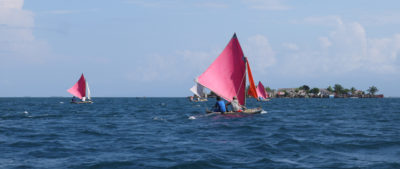
A gentle but steady southeast breeze blew across Padre Island’s paved lot at Bird Island Basin and down the three-vehicle-wide ramp, sending ripples out into the wide Laguna Madre toward two tiny humps of islands on the horizon. The sun was already high above wispy veils of cirrus clouds and a scattering of cottony cumulus. On the upwind side of the 200-yard-long paved parking lot, a field thick with waist-high olive and khaki grass waved atop rumples of sand the color of unbleached canvas. A dozen or so pickups with empty trailers, along with my SUV and ARR & ARR’s trailer, sat clustered in parking spaces near the ramp, the rest of the 100-plus spaces in the lot empty, not unexpected on a November Monday morning.
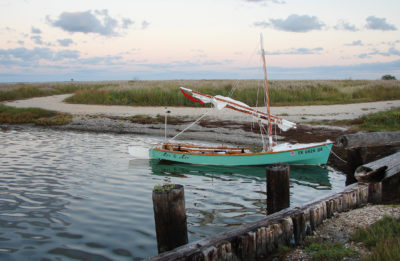
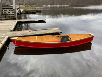
On the northern of the two docks flanking the ramp, ARR & ARR, a Ross Lillistone-designed Flint I’d built, tugged at her bow and stern lines. I ducked under the swinging lugsail’s boom. One skipper gunned his flats boat up onto a half-submerged trailer; a pontoon boat with no bimini sat tied to the opposite dock, its skipper leaning on deeply tanned forearms on its rail, also watching the ramp; and an open skiff approached at an idle. I let the breeze push the bow downwind and fill the lugsail. I ducked a gentle jibe and steered past the idling skiff, following the ripples out toward the islands and, between them, two distant markers, a tiny red triangle and a green square, each atop its own piling maybe a mile out, showing the channel to the Intracoastal Waterway (ICW).
With ARR & ARR making good headway toward the markers, I wiped the sweat from my face and put my wide-brimmed straw hat on. I had hoped to launch earlier, while the air was still cool and plenty of daylight remained for the 15 or so miles to Yarborough Pass, my destination for the evening, but I had slept in and taken my time rigging the boat, double- and triple-checking that I had all my camping and safety gear aboard. The Texas coast between Corpus Christi and Port Mansfield is mostly uninhabited and has spotty cell service at best.
 Roger Siebert
.
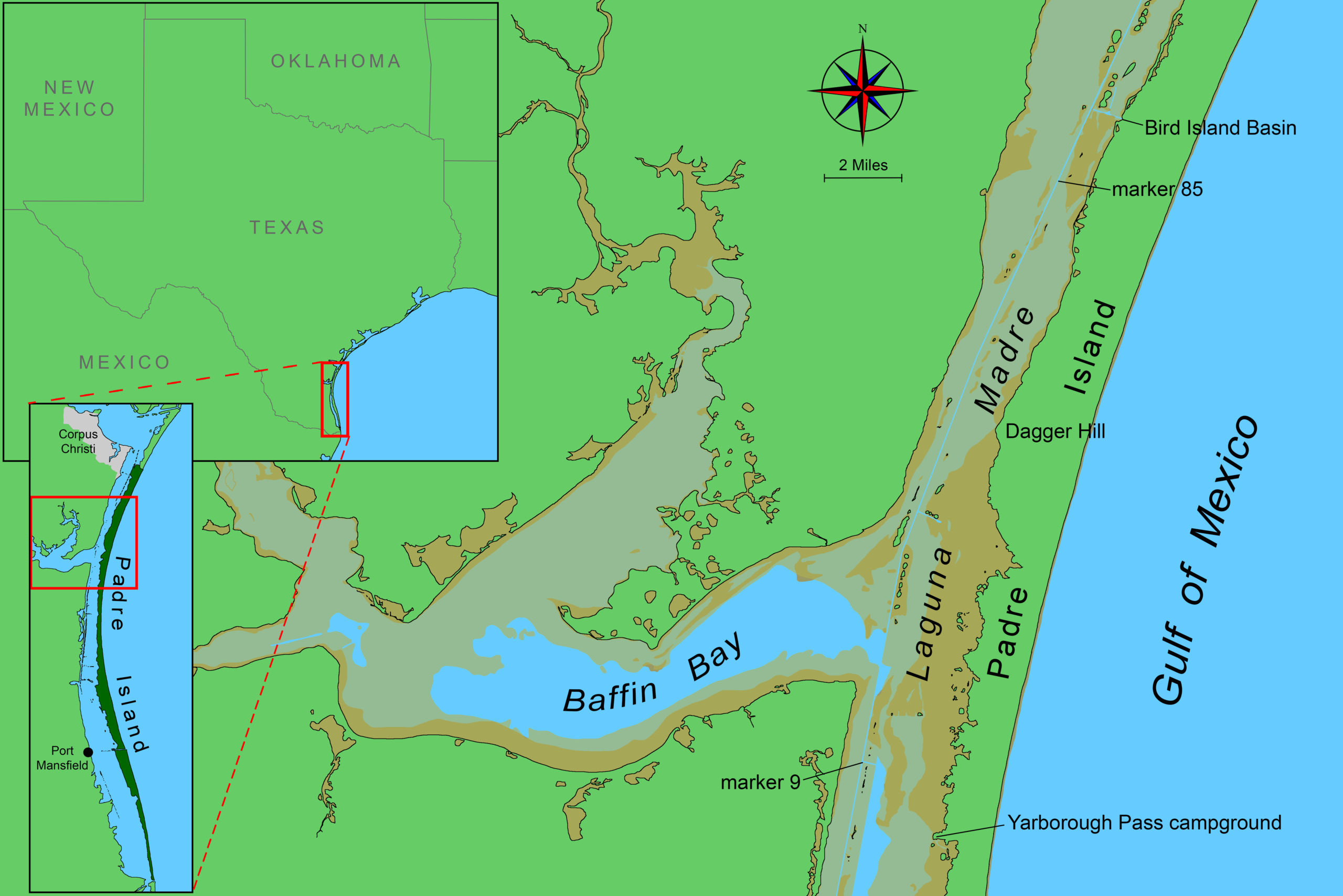
Padre Island is commonly thought of as a condo-lined beach crowded with swimsuit-clad, sunburned college students binge-drinking their way through spring break. That part of the island makes up only the southernmost 5 or so miles of what is—at 130 miles long—the longest barrier island in the world. The greater part of the island, divided into North and South Padre islands by Port Mansfield Channel—which was cut in 1962 by the Army Corps of Engineers—is an undeveloped, pristine expanse of beach, dunes, grassland and mudflats, with 70 miles of the northern island’s length managed by the National Park Service as a National Seashore and 30 or so miles of the island’s south end designated as a national wildlife refuge.
Laguna Madre runs the entire length of Padre Island and separates it from the mainland. Separated from the Gulf except at the island’s ends and at Port Mansfield Channel, Laguna Madre has an average depth of less than 3′, little rain, and scorching summers.
After only 20 minutes of sailing from Bird Island Basin, I reached the first of the islands and the ICW, where I jibed to a port tack and veered upwind until sailing southwest on a beam reach under full sail, paralleling the island’s bayside shoreline. With a mile’s fetch, the waves were built to 1′ high, which gave ARR & ARR a pleasing motion and sent the occasional whoosh of spray from her bow.
Opposite Padre Island and two to three times as distant to leeward, the mainland Texas coast was a tiny blotted line on the horizon. I checked forward and aft for powerboats and barges, expecting traffic given that Corpus Christi was falling aft just over the horizon, but I was alone.
Half an hour later, I passed the number 85 marker, pushed the daggerboard all the way down, and headed due south, leaving the ICW on a closehaul obliquely back toward the island. The chart showed deeper water, with 3′ to 4′ almost all the way to shore. I wanted to spend as much time as possible out of the ICW away from any potential barge traffic and exploring the undredged parts of Laguna Madre.
Working to windward, ARR & ARR had a sharper motion and tossed puffs of salty mist across my face. I had to occasionally sit on the rail but rarely hiked out. It was wonderful sailing and lasted a full hour before I was back in the shelter of the island, where the wind was calmer and the water’s surface only ripples.
I paralleled the shoreline until in the lee of a stretch of barn-sized, mostly bare dunes. I dropped sail, set anchor, and rested in the warm midday sun enjoying an apple and drinking nearly a liter of water. Out on the horizon, in the ICW, was the tiny silhouette of a towboat pushing two barges one in front of the other.
With the lazy water, a satisfied stomach, and the warm sunlight, I wanted to nap, but there wasn’t time, though I made a point to remember the spot as a potential one for experimenting with sleeping aboard on my second night, on the return trip.
I raised anchor, dunked it a few times to wash a helmet-sized mass of mud and seagrass from its flukes, and set it into its plastic tote in the forward part of the cockpit. I paralleled the shoreline again until near Dagger Hill, where the chart showed the water too shallow for a daggerboard, so I fell off on a broad reach back toward the ICW. The wind was steady and ARR & ARR’s heeling so slight that I lay in the sternsheets with an arm draped across the tiller and my feet propped on the far gunwale.
An hour later and back in the ICW, I approached the 4-mile-wide entrance of Baffin Bay. On my laminated NOAA booklet chart, in the broad unsounded waters near Padre Island across from the bay, a note reads, “Many uncharted rocks exist in Laguna Madre.” These rocks are of two types, those from reefs created by serpulid tube-building worms, unique to Baffin Bay along the Texas coast, and beach rocks of concreted shell, sand, and clay. The serpulid rocks range from 300 to 3,000 years old. Some living serpulid worms still hold on in Baffin Bay but they are no longer widespread or thriving. The beach rocks are 20,000 to 30,000 years old and formed before Padre Island existed, when the Texas coast was where the beach rocks now sit.
 All photos by the author
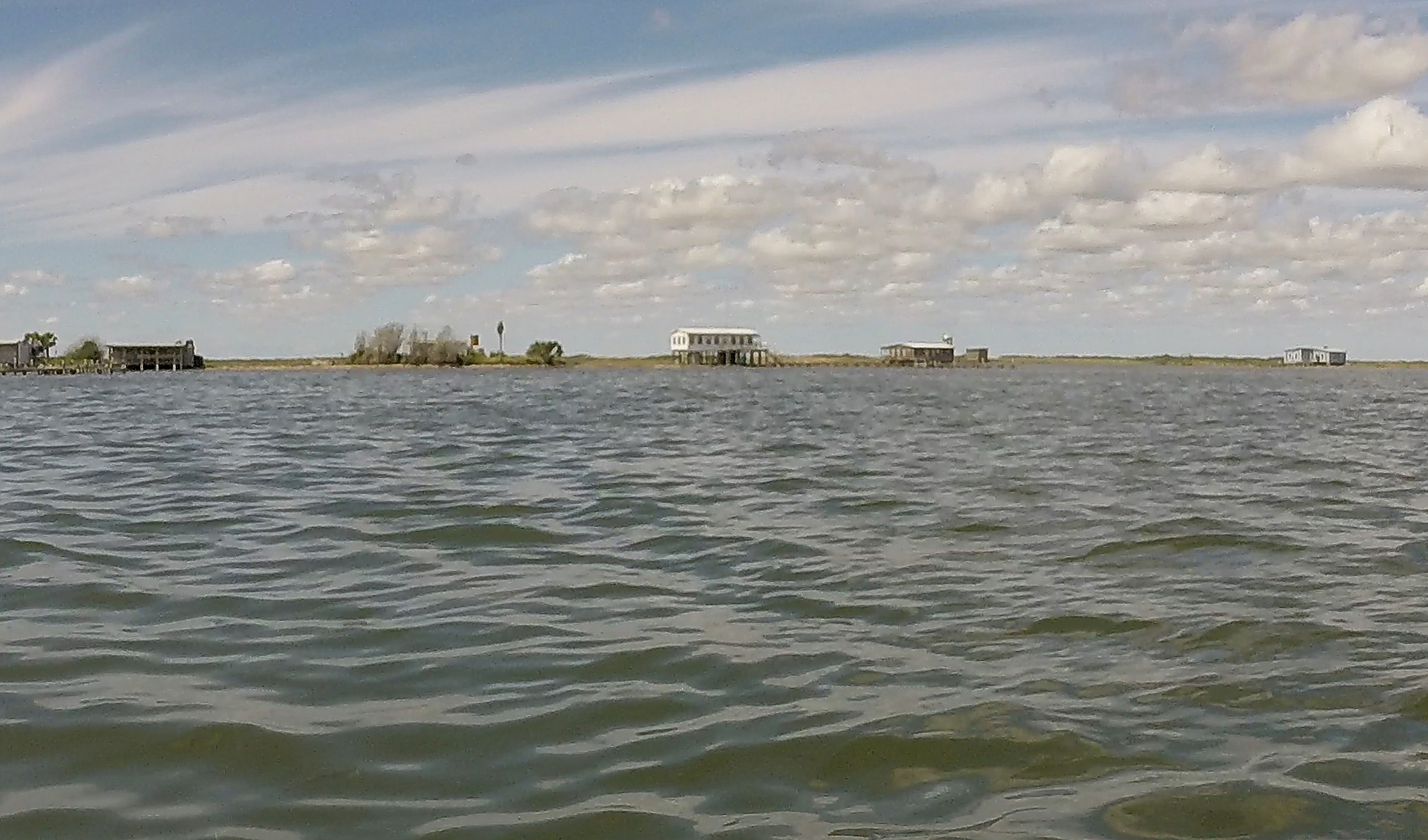
Fishing cabins sit atop spoil islands along the Intracoastal Waterway just north of the entrance of Baffin Bay. Although the cabins were built and are maintained by private citizens they sit on public land and are therefore officially the property of the state, which limits their numbers and issues renewable five-year permits for recreational use only.
With 5 to 10 miles of fetch in several directions, Baffin Bay can be difficult for small boats. I was grateful to be skirting its mouth when there were only moderate waves. Another hour and a half later, with the mouth of Baffin Bay astern and the late afternoon sun painting a shimmering sheen on the water’s surface ahead, I neared the ICW’s number 9 marker, where the chart showed a small cut through the spoil islands and into about a 4-mile stretch of deeper water that ran between and paralleled them and Padre Island. The chart also showed the area peppered with submerged rocks.
At the marker, I tacked and sailed closehauled on the starboard tack due east out of the ICW through a 50′ gap between a jagged dinghy-sized gray rock jutting 1′ above the water and a low 50′-wide island with a short length of corrugated-metal seawall on its northern end. Once through the cut, my plan was to tack again and closehaul on the port tack for about 2 miles, to take advantage of that stretch of deeper water before taking the starboard tack again for the remaining mile to the campground. Just after getting through the cut, though, I heard two knocks like a shovel striking stone. ARR & ARR had hit rock. She hadn’t shuddered or slowed, so the impacts seemed minor, but they were disconcerting: ARR & ARR’s hull is 1/4″ plywood with a single layer of 6-oz ’glass cloth.
The tides for my trip weren’t supposed to fluctuate more than a few inches, and the water would always be at least 6″ above mean lower low water, so ARR & ARR, with only 6″ draft, should clear anything not marked on the chart—without the daggerboard down. Yarborough Pass was upwind, though, so if I were going to sail there, I needed the board down and would draw 2′ to 3′.
Having taken two scrapes so soon after leaving the ICW, and not wanting to slam into a rock at hull speed, I decided instead to row the 2 miles to the campground directly upwind, allowing me to reduce my draft to the 6″ margin the tide provided. Rowing 2 miles in a straight line at 3 knots, instead of sailing 3 miles in a zig and a zag at 5 or 6 knots, wouldn’t delay my landing by any appreciable amount. I should still make landfall by sunset.
I replaced my daggerboard with the slot’s rowing plug, lowered the sail, and bent to the oars. ARR & ARR’s deep-V forefoot made it easy to maintain headway into the waves, and with a hull designed for rowing, she tracked and moved well with little effort even in the moderate headwind.
According to the chart, the campground was 2 miles dead upwind. From that distance, though, the entire island was a low stretch of subdued tans and greens; nothing discernible yet to indicate a campground. After only 20 minutes, I made out the silhouettes of four two-legged shade shelters jutting up from the island like giant half-driven staples. While still nearly a mile from the campground, my oar blades struck bottom. Ten minutes later they did so again. The parts of the bottom I struck varied from sand to mud and seagrass, not rocks, but it became clear that even if I had tried to sail to the campground, I would likely still have had to row the final mile or so.
Once within a couple hundred yards of shore, I saw an inlet on the campground’s south side. I aimed for that and, after crossing half of the remaining distance, could see that it was a slough bordered with low briny land and punctuated with equally low islets, their greenery likely saltwort and glasswort, with larger islets sporting waist-high grass in their interiors. Beyond the briny slough’s shoreline, Padre Island was a vast mix of mostly hay-colored waist- to shoulder-high grass whipping in the southeast wind. Here and there in the distance a bushy mesquite rose in a short pale green dome above the grass.
Only a stone’s throw from shore, ARR & ARR slipped over a field of seagrass just beneath the water’s surface. I stepped out of the boat into what I expected to be shin-deep water, but my feet plunged into mud beneath the grass, and I was suddenly in water up my knees. I tied a line to the foredeck cleat, slung the bitter end over my shoulder, and trudged through the mud toward shore. Black muck roiled to the surface with each step and stank like an aquarium that hadn’t been cleaned in a year.
After a half-dozen steps, my right leg plunged knee-deep into the mud, which put the water at my waist. I assumed it was only a hole and pushed on, but two steps later, my right leg plunged in again. Then my left did. And my right again. The mud was deep everywhere between me and the shore and was thick, black, and hothouse warm, surprisingly warmer than the water.
I pulled the slack out of the line, pulled the boat close for support, and plowed forward. I probably should have switched from oars to push-pole instead of getting out of the boat, but moving to the sternsheets to pole would have raised the bow in the headwind, meaning either fighting to keep the bow pointed upwind or time spent rebalancing the boat’s load while drifting back offshore. Walking the boat had seemed the better choice.
I stumbled twice, and my PFD checked my fall, but the black muck oozed inside it and my shirt. By the time I reached more solid footing 10′ from shore, mud covered me from the neck down. I stood in shin-deep water clouded black from my trudge. Still holding the bow line, I scooped up the opaque water and rinsed off the mud packed on my skin and my clothes and in my pockets.
The shore had a rough seawall, two massive weathered gray logs crudely laid one atop the other horizontally across the shoreline, separating the low muddy beach on the bay side from hard-packed sand, pebbles, and shell 2′ higher on the campground side.
I kicked at the logs to rile up any hidden snakes and peered into the recesses—I had almost stepped on rattlesnakes twice before on trips—and once I was satisfied it was safe, I shoved the bow line through one of the many gaps between the logs and tied it off. I also set my claw anchor on the campground side of the logs, its 15′ of chain reaching all the way to the boat.
Yarborough Pass was dredged between the bay and the Gulf in 1941 and had to be repeatedly dredged until the effort to keep it open was abandoned. By 1950, it was left to fill itself in. The pass is now occupied by a mile-and-a-half stretch of unimproved road running from the Gulf beach to the bayside slough and campsite. The road was currently closed, and no cars driving the beach on the Gulf side could get to the campsite. It was a Monday evening during the school year, so I wasn’t surprised that I was alone.
The campground was a rough circle 100′ across, with four crudely constructed pergola shade shelters spaced around its perimeter, one sagging in disrepair. At the water’s edge on the south end of the site, short pilings crowned by succulent saltwort supported a wall of vertical planks so weathered they had gaps I could have put my fist through.
Along the campground’s north side, the dirt, gravel and shell road snaked off into the expanse of grass and stunted mesquite. Close in and surrounding the campground was a band of shorter grasses, intermixed with knee-high stalks topped with grape-sized puffs of pastel blue-violet mistflower still in bloom, yellow beach daisy mostly gone to flaxen tufts of bristly seeds and, tucked down within, prickly pear and ankle-high meanderings of dark green saltgrass.
Etched into the campground’s crusty, sun-cracked surface were tracks from wide, knobby tires and some large cloven-hoofed animal, perhaps a large deer or a feral hog. I didn’t relish the possibility of hogs rooting through my camp overnight. I tried using my phone to figure out the difference between their tracks, but there was no signal.
After I had pulled everything I thought I’d need for the night from the boat and set it next to the closest shelter in the campground, I stripped off my quick-drying hiking clothes and neoprene booties and thoroughly scrubbed myself with body wipes, hoping to get rid of the black mud’s stench and keep any scrapes I might have accumulated throughout the day from getting infected.
Halfway through my sponge bath, I glanced across the field of grass-colored marigold in the light of the setting sun and spotted, only 100′ feet away, a mature whitetail buck, stock still in the frenzied grass. The buck was hidden from the shoulders down, but his muscular neck and a massive symmetrical cage of antlers were clear and imposing. His eyes, huge and black, were staring straight at me. His fur was cast in gold by the sunset light but for the shock of white on his throat. I turned away for a moment and when I looked back, he was gone. The brief visit put my mind at ease about feral hogs making the tracks I’d seen.
In dry camp clothes and shoes, I hung my wet clothes on a length of paracord tied between a pair of nails driven into the shelter’s legs. The evening breeze whipped the clothes almost horizontal, snapping them like gale warning flags. While the remaining evening light faded, I pitched my bug-net bivy 10′ from the shelter, using my boathook and pig stick as tent poles and set the bivy’s ultralight tarp in a taut A-frame above. The bivy was new for me, less roomy than my usual tent, but with its small footprint and an entry at its head end, I would be able to pitch it on the boat, a way I thought could expand my camping options.
I dug a fire pit on the upwind side of the campground so any sparks that took flight would have the entire length of the hard-packed surface to burn themselves out, well before reaching the grass on the campground’s downwind side.
The wind made it difficult to light the fire, even with the excavated dirt piled on the pit’s windward side. Only a few strikes of the lighter’s wheel managed to produce a flame, and those whipped and vanished like will-o’-the-wisps, none lasting long enough to start the fatwood. I pulled out my emergency fire starter—cotton balls worked through with petroleum jelly—and got flames almost instantly.

After changing into dry camp clothes at the Yarborough Pass campground, I relaxed next to a fire. The pit I dug not only sheltered the flames from strong winds but also made it easy to bury the ashes afterward to leave a minimal trace. Driftwood on the bay sides of Texas barrier islands is scarce so I carry my own firewood from the mainland in a 1-1/2-cubic-foot plastic bin with lid. When the bin is empty, I use it to carry out my trash and a fair bit of refuse left by previous campers.
After I got a few larger pieces of wood burning, I took a meandering route back to the bivy, soaking up the night sounds and letting my eyes adjust to the dark. Ducks grunted in the wetlands, and waves plashed against the seawall. Stars were visible overhead in an arching band from east to the west, but the rest were washed out by the glow from Corpus Christi in the north and Port Mansfield to the south. Venus, however, hung bright and steady in the southwest sky and cast a dancing, dappled reflection on the bay.
My firelight dinner was two pieces of flatbread and a can of chowder, served cold. I preferred not cooking, given the heat of the day, the mildness of the night, and the warmth of the fire. The wind kept mosquitoes at bay and carried the briny and mucky scent of the island’s wetlands.
Once the last of the firewood had burned down to glimmering red coals, I drenched it with saltwater. It hissed and steamed as I walked the perimeter of the campground. The lights of a jet blinked overhead; far to the west, faint green channel marker lights winked out every few seconds; and even more faintly but stretched across the bulk of the western horizon, wind turbine warning lights blinked in an unsynchronized mass like fireflies over a midsummer meadow. Orion had risen in the east, and Venus had shifted to red-orange and tucked among the wind turbines’ lights, betrayed only by its steady glow. My headlamp reflected a scattering of pinhead points of light just inside the edges of the grass bordering the campground, bright and cool like dewdrops in early-morning sunlight; they were wolf spiders’ eyes, deceptively beautiful.
After I checked the boat, I crawled inside the bivy for the night. The tarp thrummed in the wind, beating against the bug netting only a foot above my face, and my clothes on the paracord outside whipped and snapped. Despite all the noise, I fell asleep quickly.
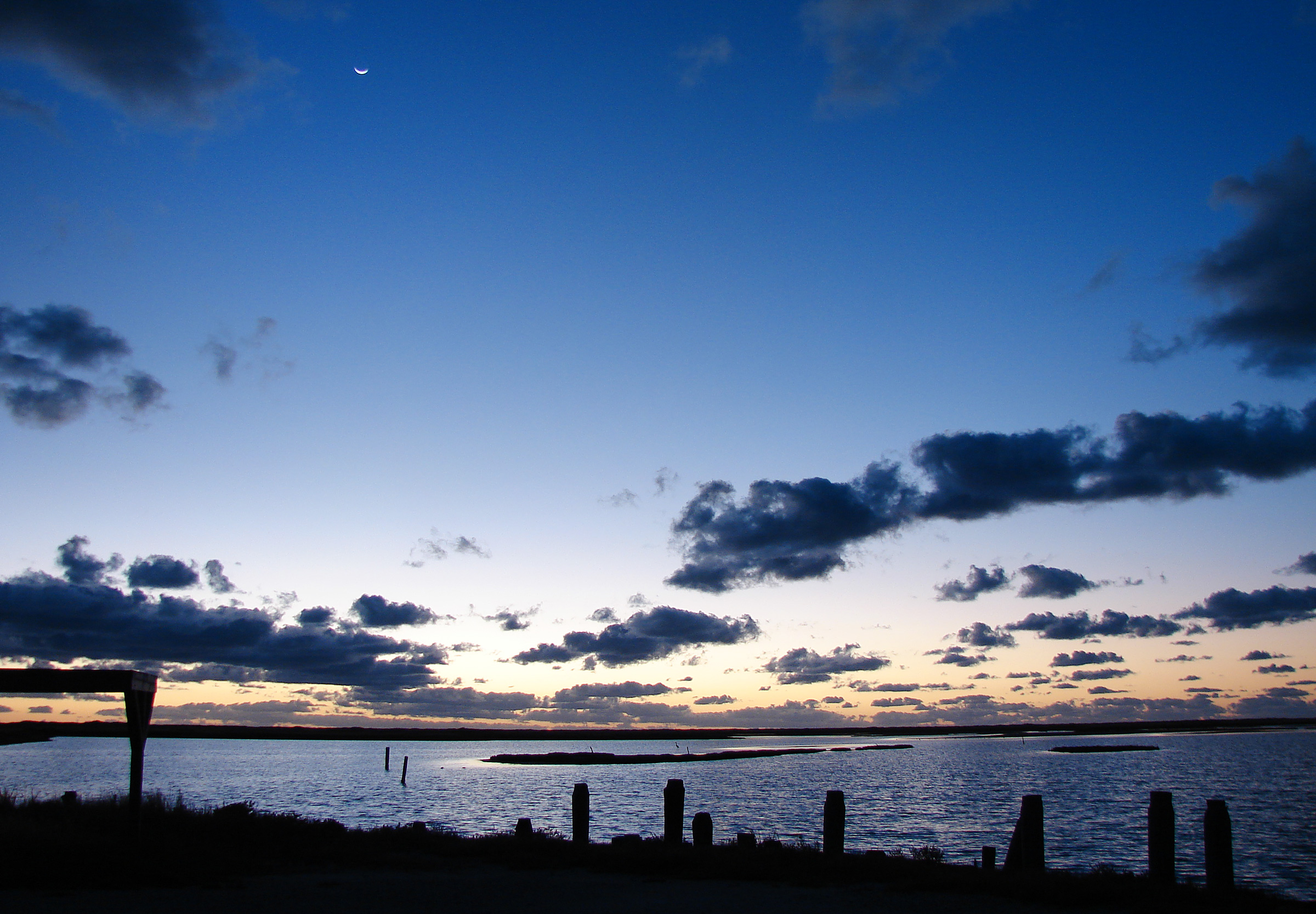
Just before sunrise at the Yarborough Pass campground, a crescent moon hangs high above islands in the slough toward the east-southeast, past the silhouette of a shade shelter and the seawall’s pilings.
I awoke at 5:30. The tarp and clothes were still and the only sound was the whine of one or two mosquitoes between the net and the tarp. It was dark. I rose even though, aching to get out of the confines of the bivy to stretch the stiffness from my joints. There was a breeze but much too weak to move the tarp or the clothes. A sliver of a crescent moon hung in the sky to the southeast and lay a wavering band of light across the still water of the slough. A trail of fresh cloven-hoof tracks lay stamped in the crusty ground, some pressed into my footprints from the evening before; the trail came within 5′ of my bivy.
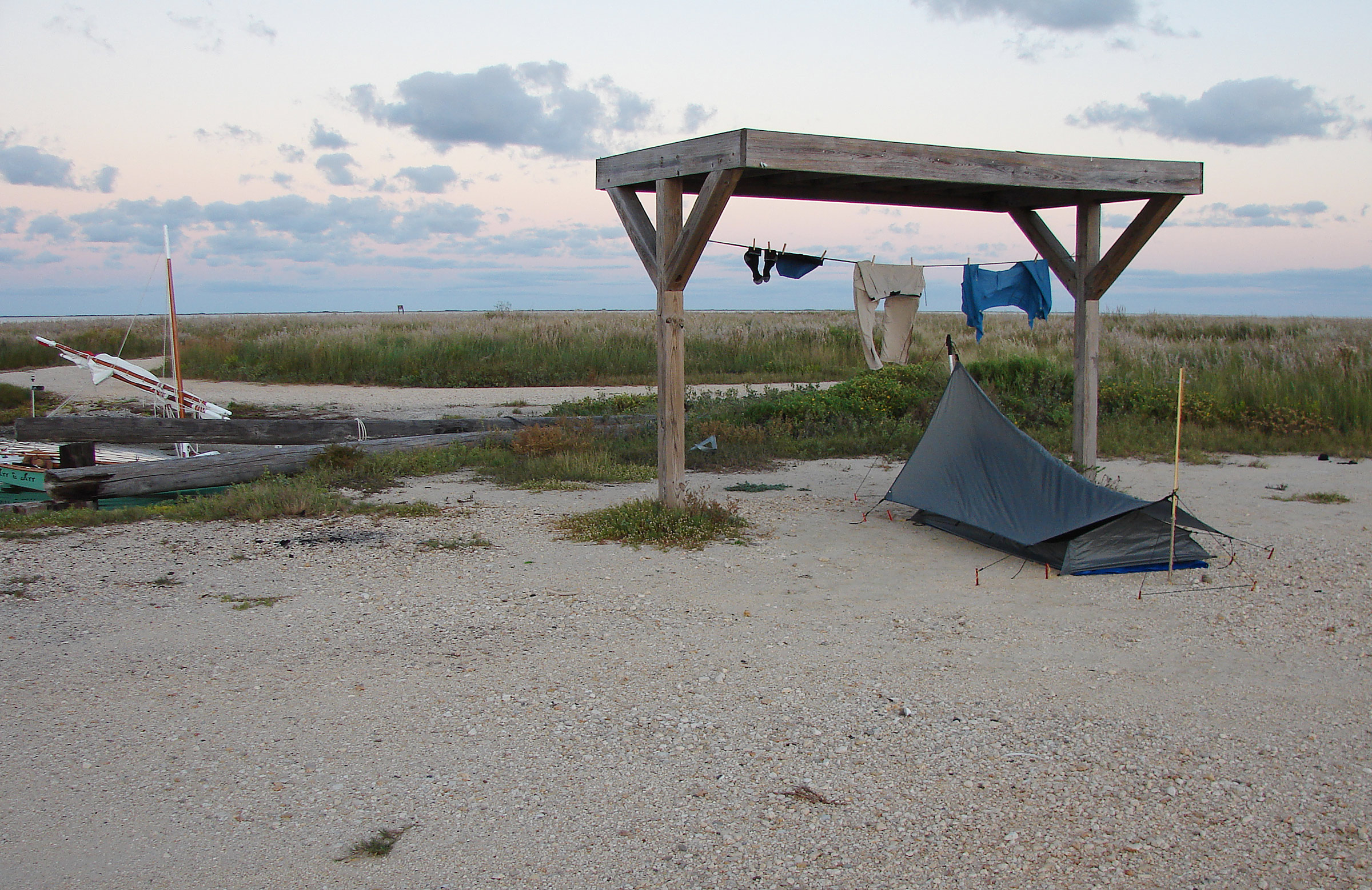
My new shelter is a mesh bivy with a tapered silnylon tarp. A big-box-store plastic tarp protects the bivy’s bottom from shells and gravel. My hiking clothes hang still in the morning air; I always carry clothespins to prevent breezes from carrying them away.
I buried the ashes of the fire with the dirt I dug for the pit. I made coffee over my backpacker’s stove and sipped it while eating granola and milk in a baggie. The eastern sky finally grew light, cobalt at first, then through cerulean and gold to persimmon. The rising sun fueled the breeze and my hanging clothes swung again. I broke camp with the rising sun and the building breeze, changed back into my hiking clothes, and loaded the boat. The weather channels on my VHF were silent. I adjusted the squelch, but the speaker jumped directly from silence to steady static, no hint at a voice. My phone had no cell signal, so I couldn’t get a weather forecast there, either.

Beyond ARR & ARR, the road at Yarborough Pass snakes off another 100 yards and ends at Laguna Madre. With the boat’s yard, boom, and sail lashed together, the halyard, topping lift, and sheet position the mass out of the way while rowing and for secure storage overnight.
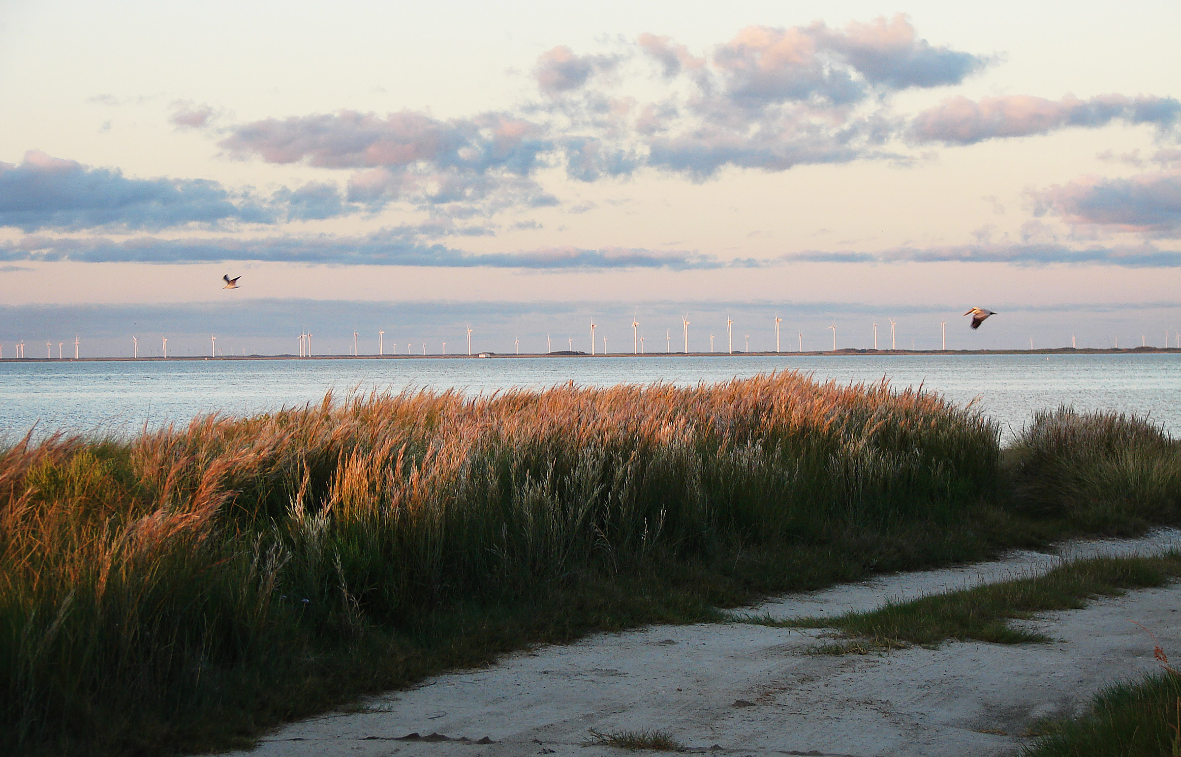
Seacoast bluestem and other grasses swayed in the early morning light. Wind turbines filled the horizon on the mainland two to three miles northwest of Yarborough Pass. The white pelicans, with their distinctive black wingtips, arrive not long after Labor Day to winter along the Texas coast.
I shoved off and climbed aboard, hurrying into position with the oars. The wind blew strong enough by then to threaten to push me onto the mud shallows that ran out from the point between Laguna Madre and me. I rowed around the shallows without grounding and, once in the 1′ to 2′ of water, let the wind push me from the island. I took my time stowing the oars and raising sail. The run back to the ICW was comfortable. The apparent wind was easy, and with the board up, Baffin Bay’s rocks didn’t pose a risk. I reentered the ICW by the same route I had left it, through the little cut between the jutting gray rock and the islet with its corrugated-metal seawall.
Again, the waves along the mouth of Baffin Bay were unexpectedly timid. The wind came in sporadic breezes between calms, the blows too enduring to call gusts but too brief to build anything more than dark flashes of ripples, and in between the water smoothed itself into what seemed like a leaden film. The result was lazing about when there was no wind and fine sailing when there was, leaving a gurgling wake swirling well aft.
I kept an eye on what I suspected was sapping the wind into its lulls. To the southeast, beyond Padre Island and well out over the Gulf, spotty but thick billowy cumulus clouds had built over the previous hour and cast canted gray veils of rain beneath them. None of the clouds had grown into anvil-topped cumulonimbus, though it was early yet. The ominous sky did not match the forecast I had seen on my phone the previous morning. I checked the phone, but still there was no signal.
To the north, at the far side of Baffin Bay’s mouth, the ICW makes a slight eastward turn behind a chain of six spoil islands to starboard. Atop the islands sit fishing shacks, each with a weathered pier, some little more than a row of pilings across the shallows.
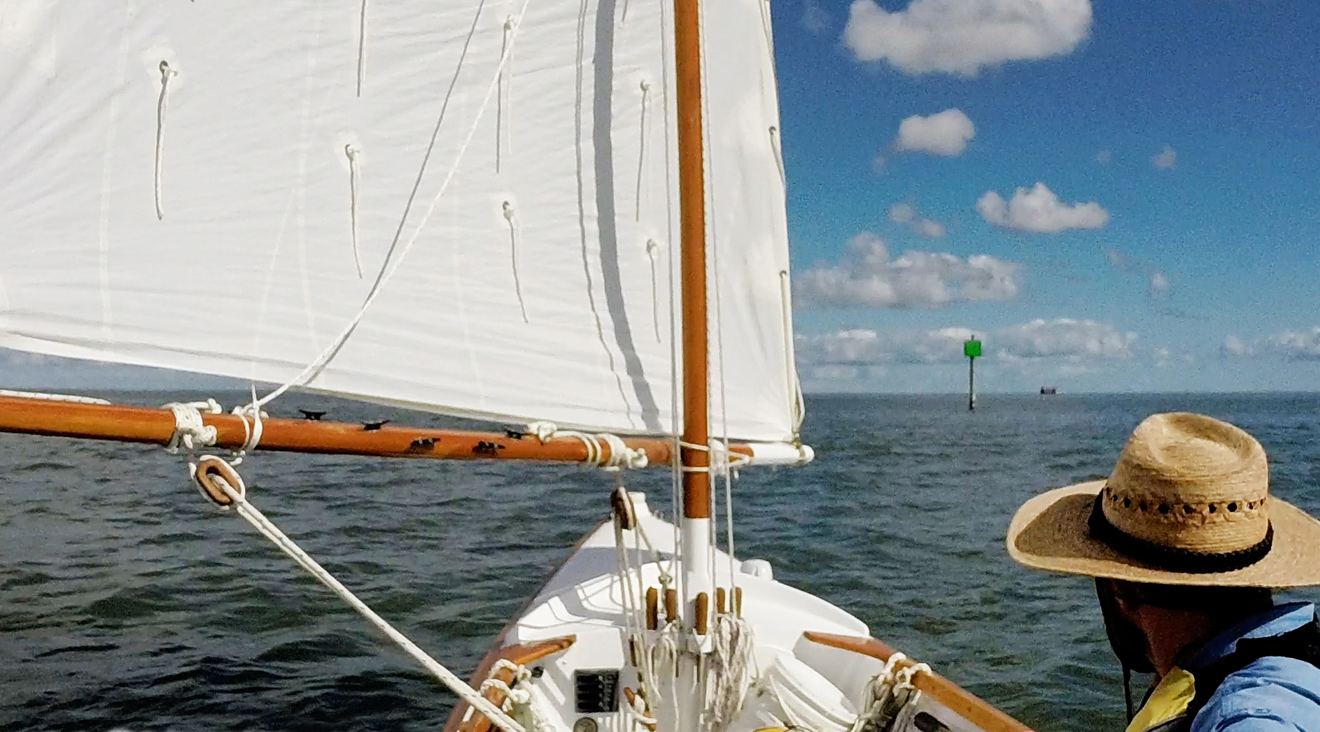
Most of the markers along the ICW in Laguna Madre are simple green squares or red triangles atop pilings. Every other marker or so, such as the one pictured here, is topped with a flashing or occulting light. The structure in the distance is a large fishing cabin, its spoil island still not yet visible beyond the horizon.
Over the handheld VHF clipped to my PFD, a deep gravelly voice said, “Come on around. I’m sitting still with a broken rudder.” Another equally gravelly voice replied with a few syllables I couldn’t make out. The two must have been towboat skippers. No smaller boat would need that sort of coordination. The transmissions had been strong, and the ICW was empty astern, so I assumed the towboats and barges were somewhere around the bend ahead.
The ICW along this part of the coast is barely wide enough for one barge to pass another on a straightaway. They need more room when coming around a turn, even one as slight as that. I prefer to be out of the way and on a steady, predictable course by the time towboats with barges or other vessels with limited maneuverability draw near.
The chart showed no soundings between the spoil islands to starboard, which meant the water there was skinny indeed. To port, the chart showed only 1′ to 2′ of water and more rocks. In the fluky air, I doubted my ability to remain safely hugging the channel’s side, especially if in the barge’s wind shadow. I would be at risk of drifting either into the barge or into the shallows and rocks downwind of it. In either situation, I didn’t want to have to scramble to switch from sail to oars.
The easiest solution was to get out of the channel before the towboat and its barges reached me and wait for them to pass. I would need to switch to oars for part of the maneuver whether when leaving the channel for the skinny water between the spoil islands to windward or returning to the channel from the rocky shallows to leeward. I chose the former, guessing that the shallows between the spoil islands were sand or mud instead of rocks and wanting to get the more difficult part of the maneuver out of the way first and simply sail back to the channel afterward on a run with the daggerboard up.
Having a plan bolstered my confidence, so I sailed on, passing one spoil island then another before the barge emerged around the northernmost of the six islands. At the next gap between islands, I dropped sail, lashed it with the boom and yard, used the halyard to raise the bundle out of the way above my head, and rowed into the gap. To the south, the three green-square-topped channel markers lining the ICW from where I had come closed in on one another until they lined up like soldiers in formation—I was at the edge of the channel—then they eased apart again, but on their opposite sides, and I was in the clear.
Once I felt I was far enough out of the channel, I slowed my rowing to maintain my position against the sporadic southeast wind and kept an eye on the lay of the markers to ensure I didn’t drift back into the channel.

To the northeast of the entrance to Baffin Bay, a towboat pushed two barges lashed one in front of the other. A typical 195′ × 35′ barge can carry 1,750 tons of cargo, a load that would otherwise require 70 tractor trailers and four times the fuel.
The towboat pushed its barges past without incident. I stowed the oars, raised sail, returned to the channel on a run, and headed up and on my way.
After I rounded the turn, I passed what I assumed was the towboat with the broken rudder sitting immobile with two tandem barges.
Shortly after leaving them behind, I heard over the VHF, “Sécurité, sécurité, sécurité.” The Coast Guard station in Corpus Christi advised all stations to switch to channel 22A, where they broadcast a weather advisory to expect the wind to back overnight along with an increased chance for rain. The original forecast was for the weather to turn the following day, which was why I had cut my originally planned three-night trip to only two, but if it were now forecast to turn overnight, I needed to be off the water by nightfall.
A norther was the last thing I wanted to confront on the bay side of Padre Island. With a fetch of 5 to 10 miles down Laguna Madre, the wind could rile up breakers over the mile-long shallows and slam them relentlessly into the island’s bayside shore. The spotty line of gray-bottomed clouds on the southeast horizon had yet to build anvil tops or get any nearer to me, and their rain had petered out. They could have been just ordinary Gulf clouds, with the front yet to arrive from the north.
Given the Coast Guard’s advisory, though, my prospects for continuing with my cruise and a night sleeping aboard seemed slim. There was nowhere between Yarborough Pass and the takeout at Bird Island Basin to pitch a tent ashore without breaking national park rules, and there was no excuse for ignoring the Coast Guard’s weather advisory.
I kept sailing toward Bird Island Basin, checking my phone for a signal as I went. I’d decide what to do when I got a detailed forecast. After passing the edge of the shoals stretching out from Dagger Hill, I retraced my outbound route and close-reached in the southeast wind back toward Padre Island. Once a quarter mile from shore, I sailed on a beam reach paralleling the shoreline hoping to find anything protected from the north where I could drop anchor, check for a cell signal, get an updated forecast, and potentially stay for the night, but I found neither protection nor cell signal.
I passed the spot where I had stopped for lunch the day before. The shoreline made only a slight indent there, not enough of a niche to consider a cove and exposed to winds from every direction except for within a couple of points of southeast. I sailed on, but instead of continuing to follow my inbound track by falling off back toward the ICW’s 85 marker, I decided to hug Padre toward Bird Island Basin, still hoping to find a bit of protection in the shoreline. At the very least, I would reach the campground about a half-mile south of the boat ramp and could possibly pull ashore or anchor there. And even if I couldn’t, I’d heard about a cut I could take through the shallows to the boat ramp instead of having to backtrack first to the ICW. Finding the cut might also take some time, but I preferred exploring new ground, and the sun was still high.
A half-hour later, with no promising spots materializing, I saw the distant cluster of boxy white campers and RVs at the Bird Island Basin campground.

Although Laguna Madre is shallow it’s rarely clear, and local sailors sometimes joke about their centerboards or daggerboards doubling as depth sounders. My daggerboard dragged ARR & ARR to a halt several times while I sailed outside the dredged ICW channel. The clouds hanging over the Gulf beyond Padre Island had appeared menacing by midmorning but, as seen here, had abated by early afternoon into just plain old puffs of cumulus.
A single sail glided across the water from the cluster of campers toward the spoil islands, which lie 1/2 mile from Padre, and my mood brightened. The vessel’s skipper might know the way through the shallows to the ramp. Then the sail cut sharply 180 degrees back toward the campers, and I recognized the tight, winglike shape and the efficient undulating motion of a windsurfer, and not a promise of a path through the shallows to the ramp.
I closed in on the campground and spotted a cordon of buoys marked “No Boats.” Three-quarters of the way around the arc of buoys toward the ramp, ARR & ARR dragged to a halt in a mass of seagrass. I lowered sail, cinched the docklines to the foredeck and quarter cleats, hung the fenders back in place, pushed off the seagrass with an oar, and rowed toward the ramp.
The seagrass grew in thick, roundabout-sized masses, and occasionally I had to push off with an oar again. I took my time at it, though, with the sun still high and a reluctance for the trip to end. It had been too brief a trip to the Gulf, but prudent to depart while its gentler side still showed.
![]()
Roger Siebert is an editor in Austin, Texas. He rows and sails on local lakes and trailers to the Texas coast when he can.
If you have an interesting story to tell about your adventures with a small boat, please email us a brief outline and a few photos.

Good trip, nicely written. Thanks.
Thank you, Steve.
Roger, always enjoy your writing. For awhile I enjoyed being in Padre’s skinny water again.
Thanks, Bob. I’m grateful to be able to share.
Ah, that black mud on the Texas coast!
Yes, you know that mud, don’t you, Tom.
Since I know you as an excellent editor, I am not surprised to read about your excellent sailing skills. I enjoyed this account very much.
Thank you, Vickie. I’m glad you enjoyed it. Hope to see you around the neighborhood again soon.