After seeing a strip-built kayak being paddled many years ago, I started dreaming of building one for myself. When the COVID-19 pandemic hit, I found myself working from home with a little extra time on my hands: it was my opportunity to fulfill my dream, and I started looking seriously at companies that offer complete kits. I had little woodworking experience and wanted a basic beginner-friendly kit, as I had no interest in lofting, building from scratch, cutting lumber, milling strips, etc. I had dreamed of this for years, but strictly as daydreaming. The idea of building my own boat was intimidating, and I never thought I would have the time or skills to make the dream into a reality.
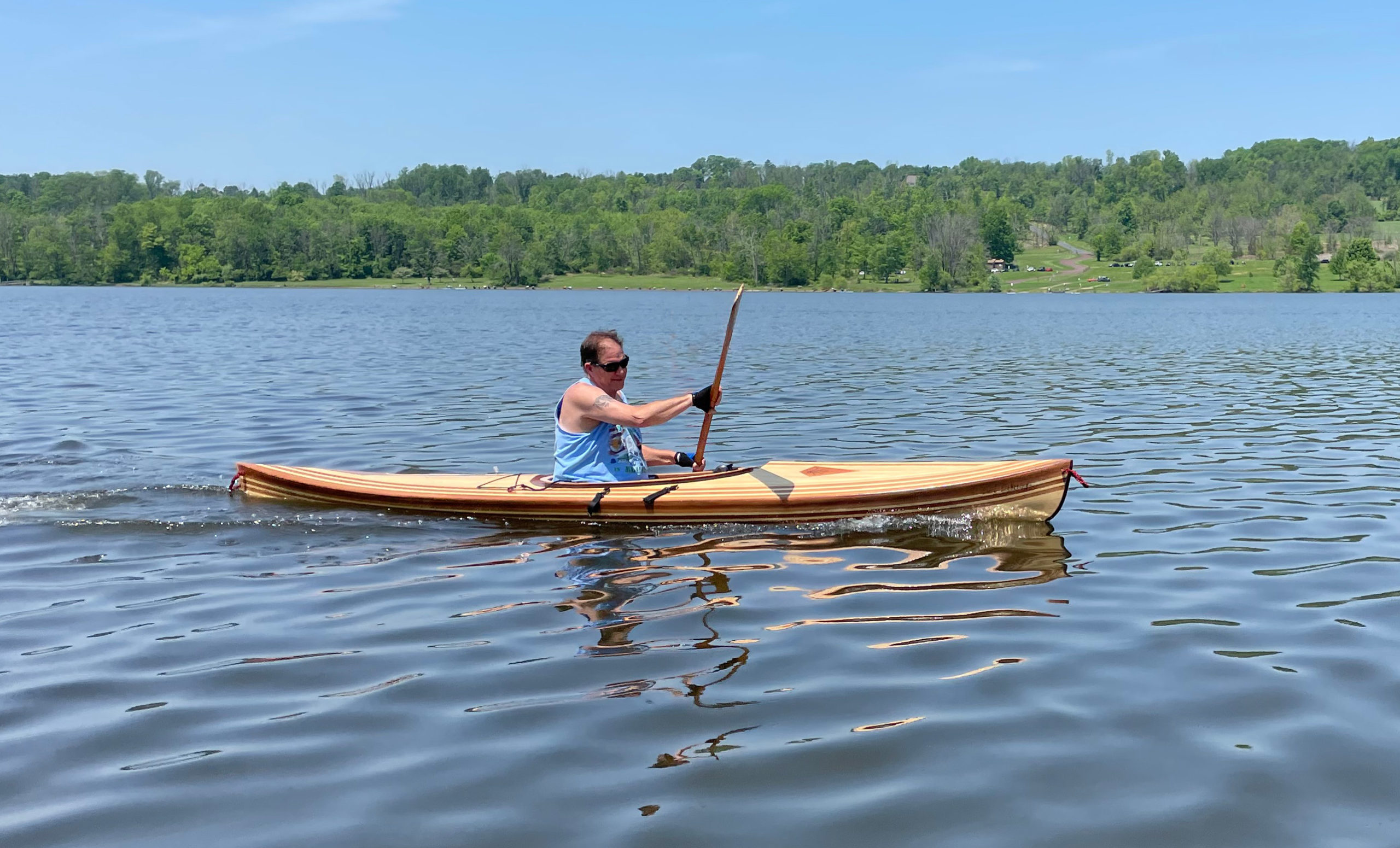
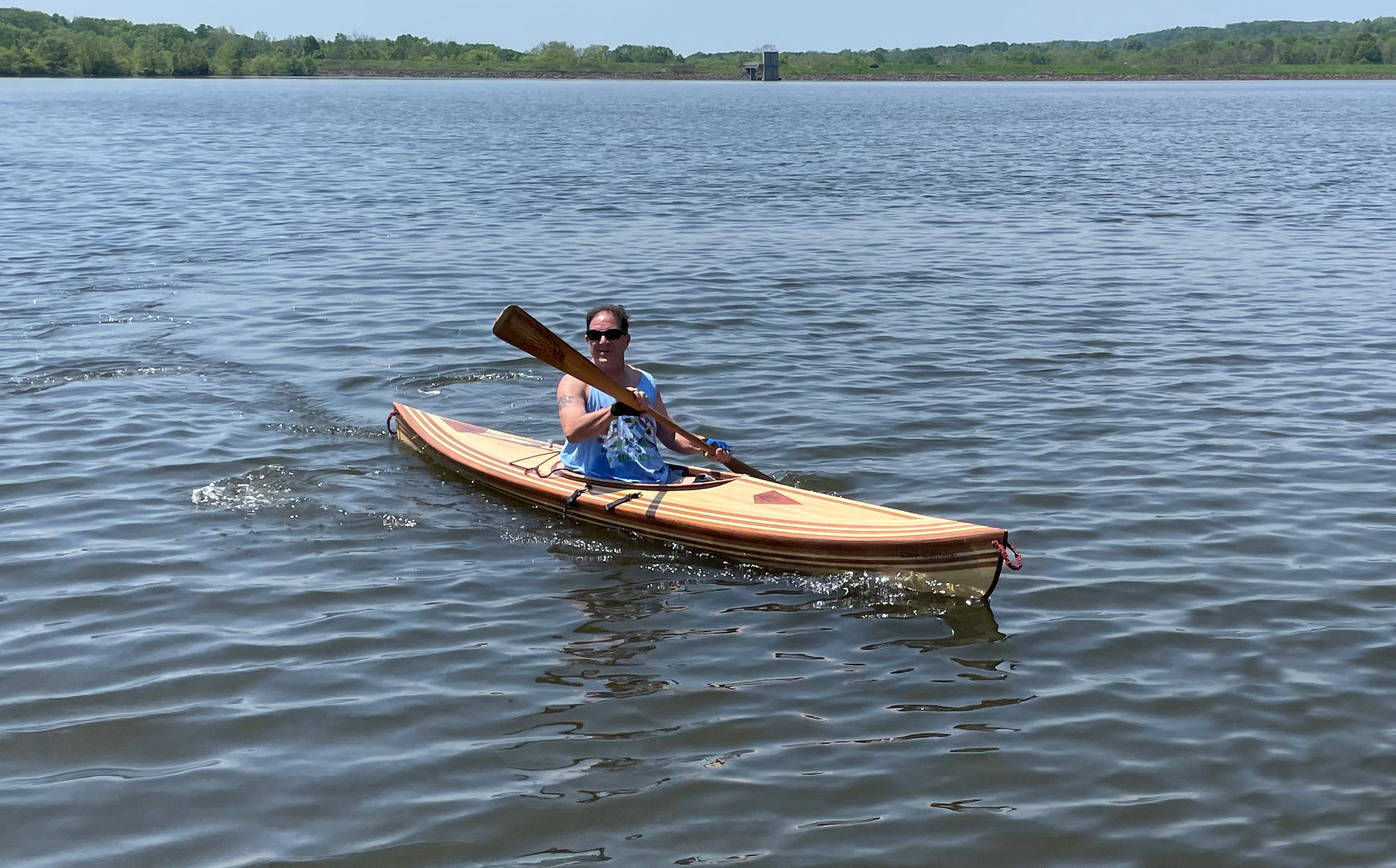
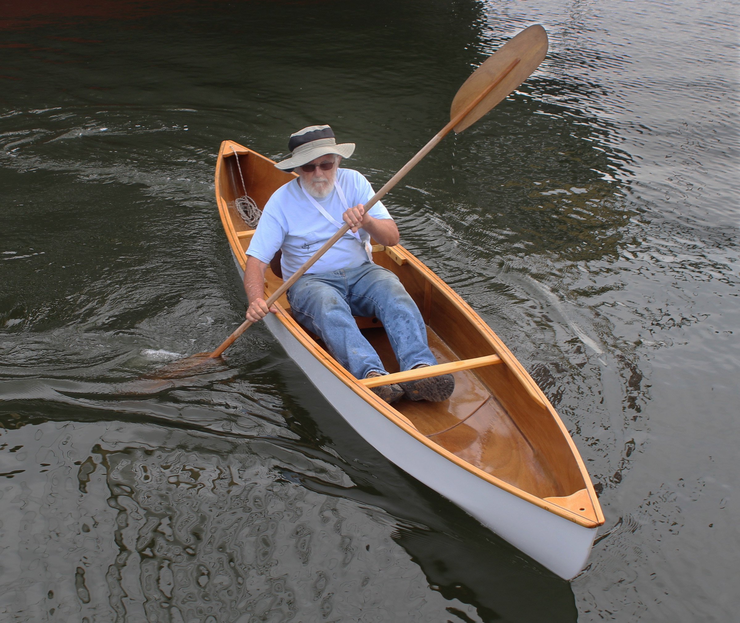
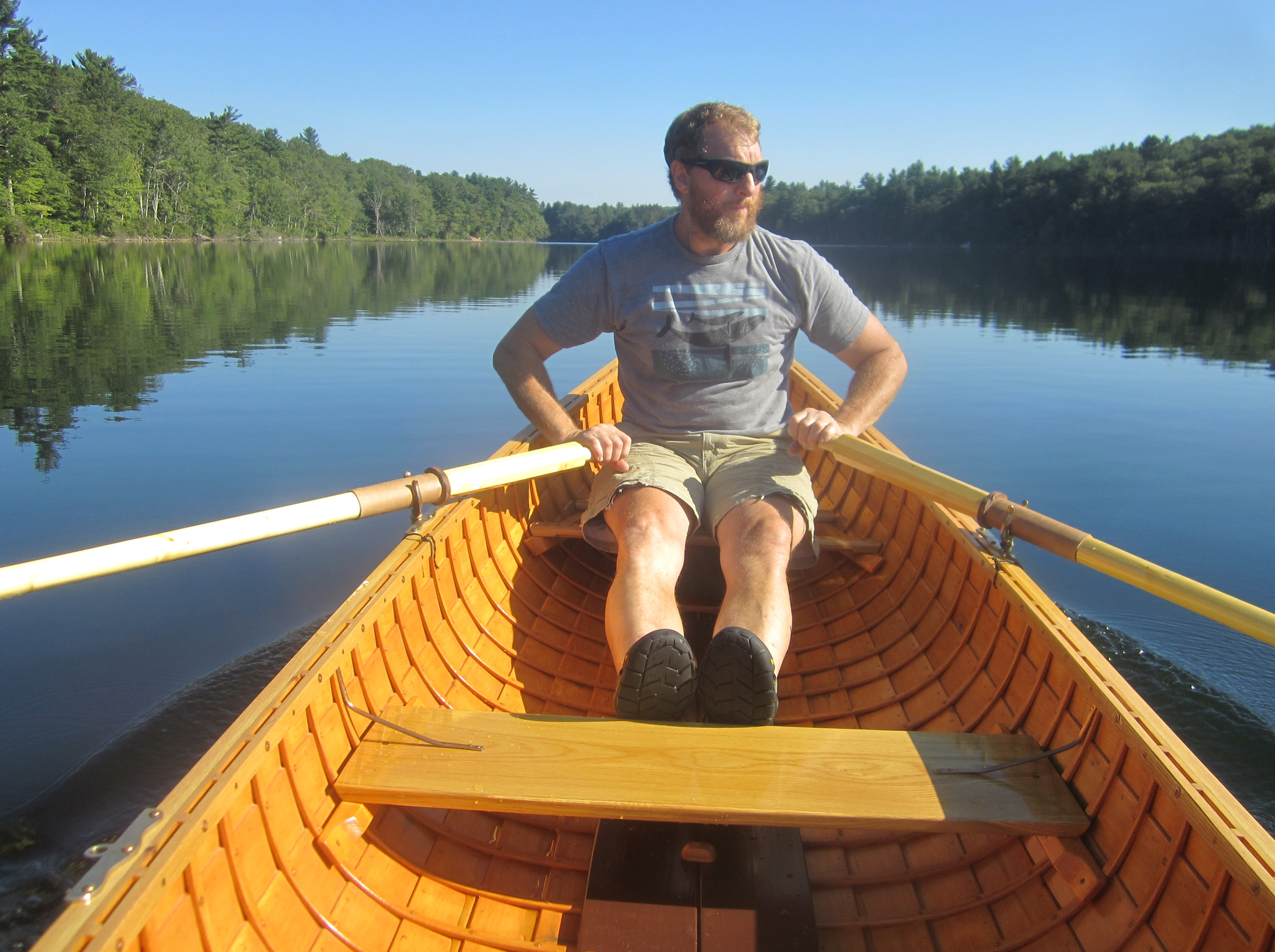
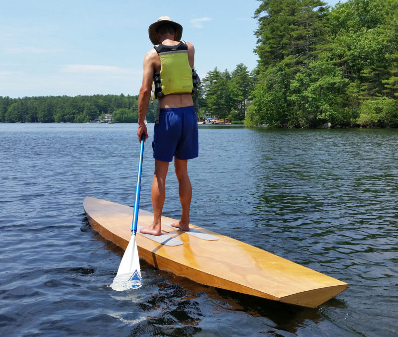
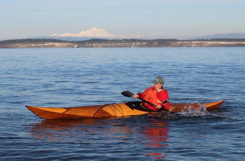
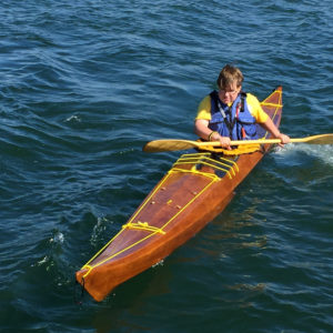
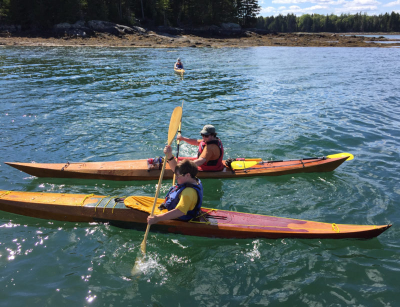
After spending many hours on the water over the last 15 years, I consider myself an experienced kayaker and knew I wanted a recreational boat for easy paddles on my local lake. I am a fair-weather paddler who does not look for whitewater adventures—just lazy days on the water with a sandwich and a few cold drinks. After comparing kayak kit packages and manufacturers, I decided on the 12′ 8″ Excursion model from Newfound Woodworks of Bristol, New Hampshire.
I had many questions about the build process, no prior working experience with epoxy and fiberglass, and was interested in building my first boat in a classroom setting, but when the pandemic hit, all in-person classes were canceled. I really wanted some hands-on experience before taking on the build, and the folks at Newfound, Alan Mann and Rose Woodyard, listened to my concerns and scheduled a day of one-on-one instruction with me. They shared techniques and tips as we worked with the materials, which gave me the confidence to tackle the project and was key in my decision-making process.
Photographs by and courtesy of the author
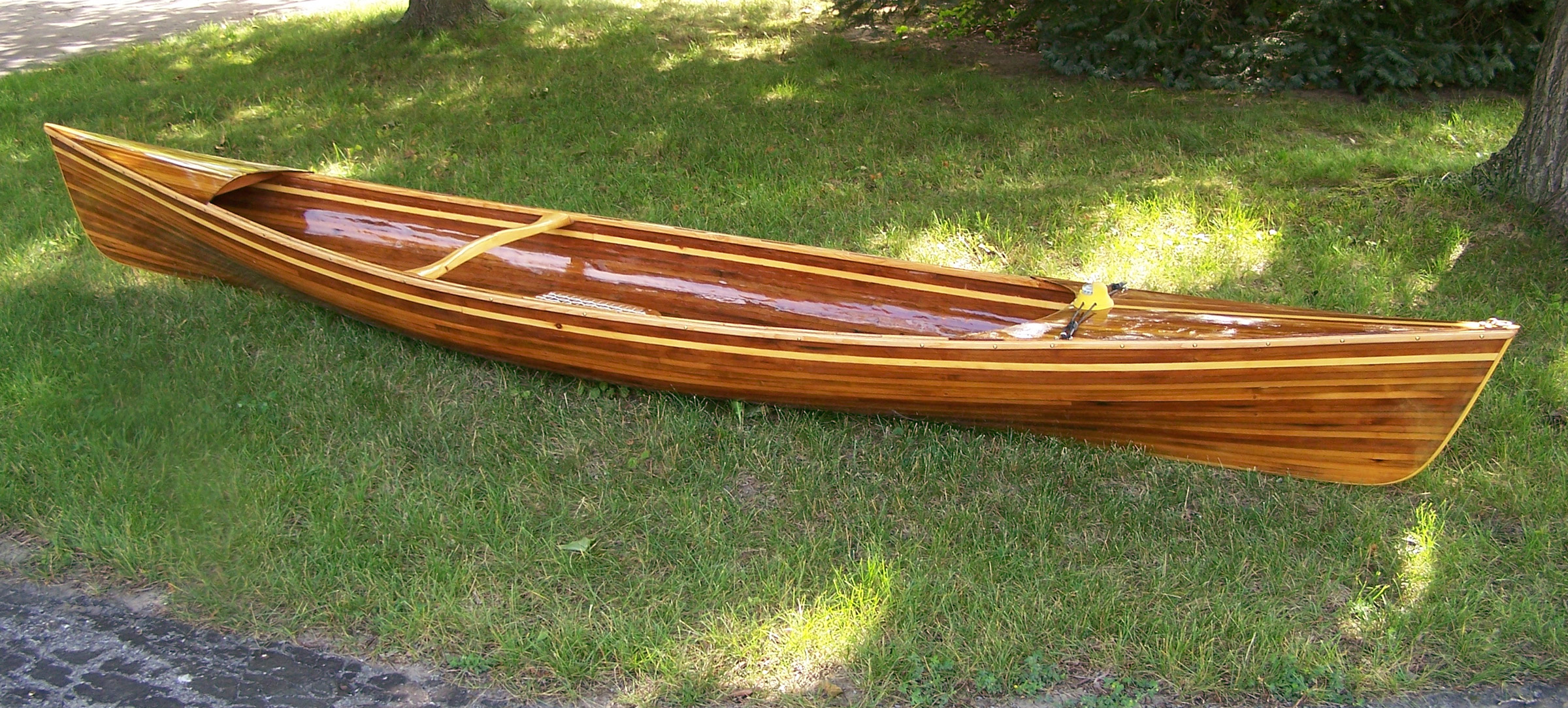
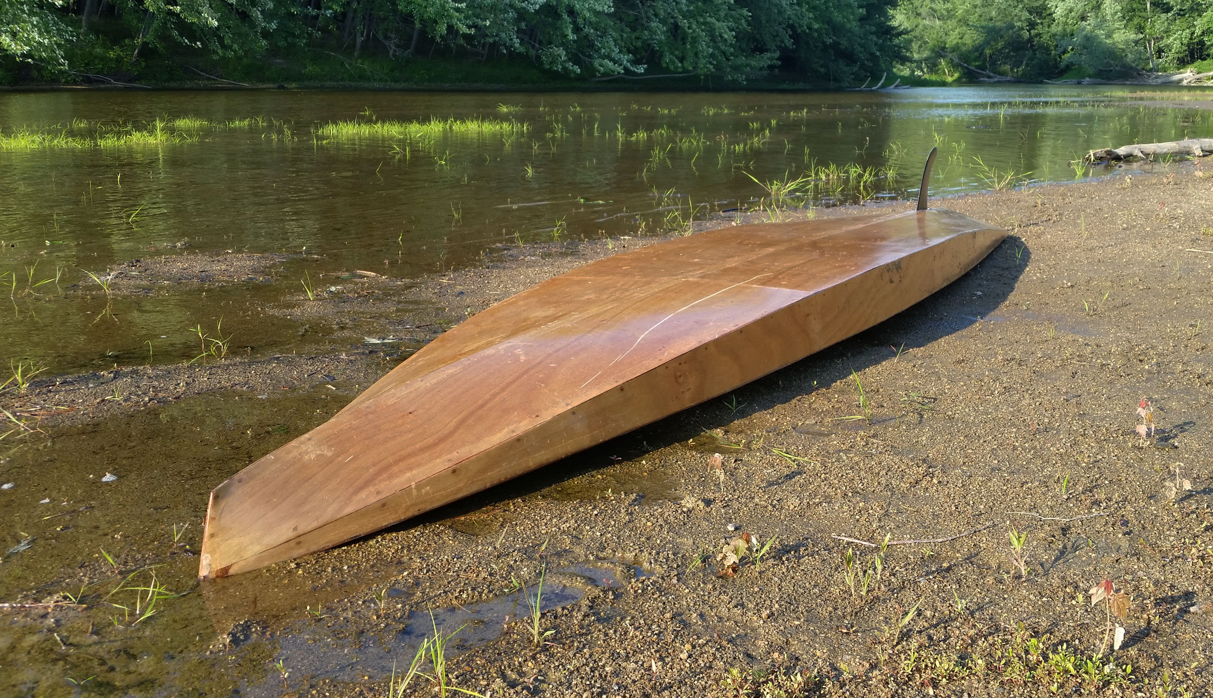
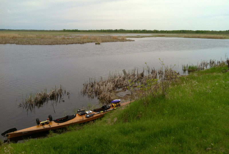
Built according to the instructions, the Excursion can weigh as little as 37 lbs. Extra fiberglass on the author’s kayak brought its weight up to 44, which is still easy for him to carry to the water’s edge and back.
A Newfound “Pre-Kit” arrived first with instructional DVDs that demonstrated and clearly explained the construction methods step by step; the DVDs proved to be invaluable.
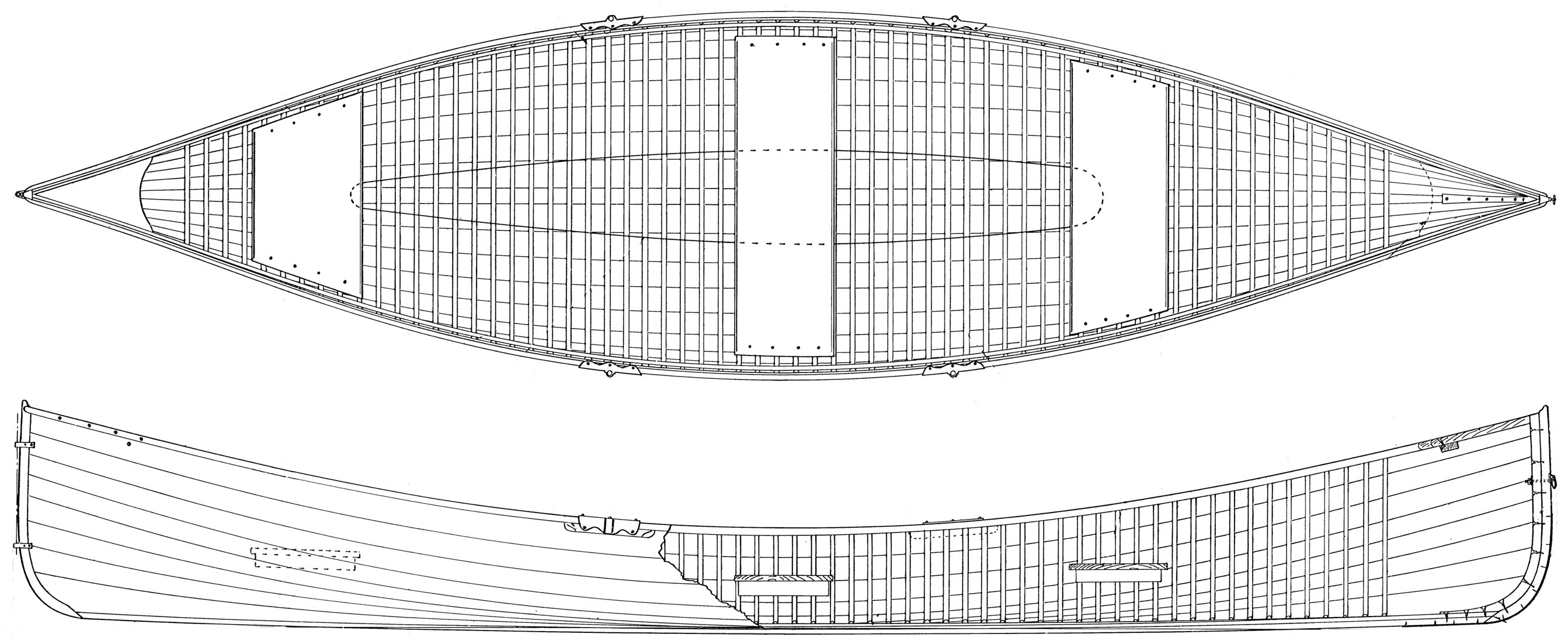
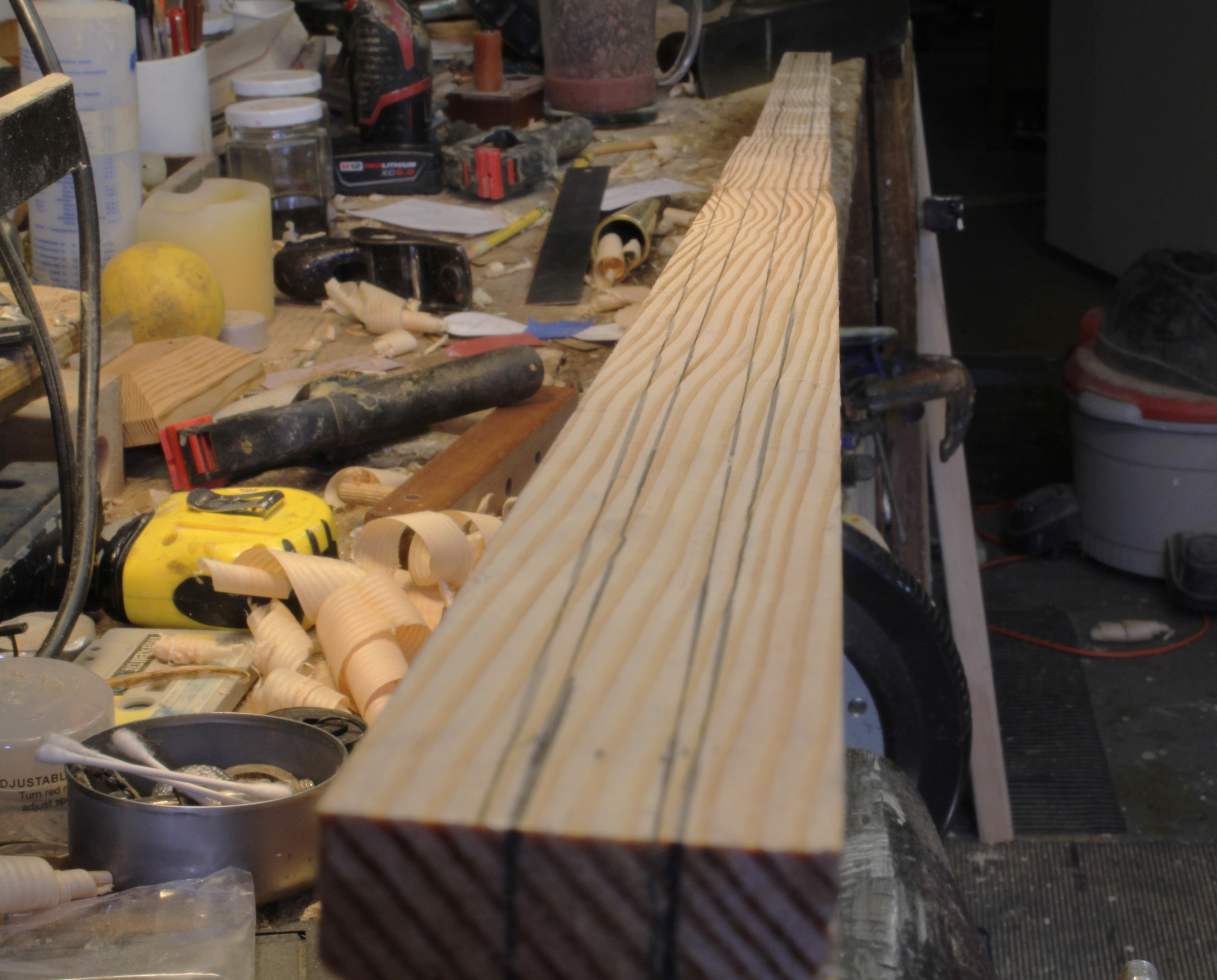
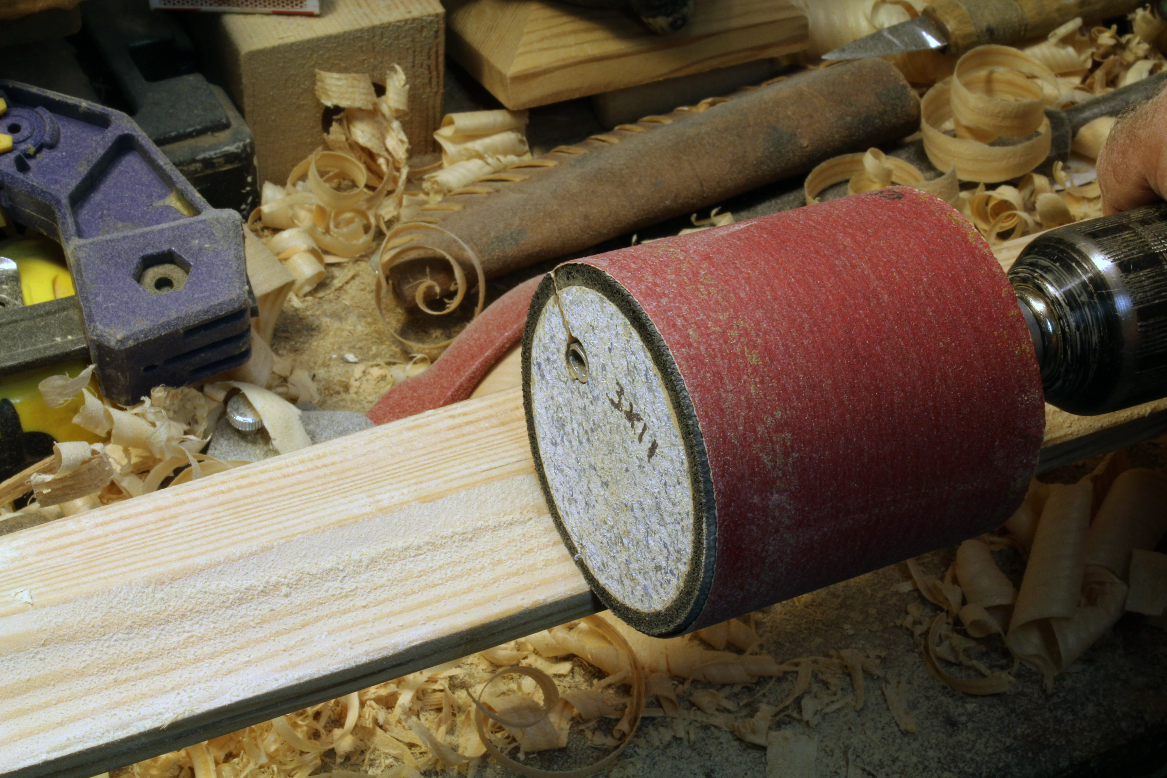
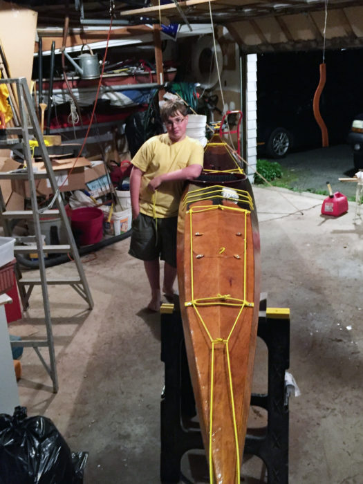
The pre-milled cove-and-bead strips arrived in a 14′-long plywood shipping crate designed to be used as the box-beam stand during the build–a great way to save time compared to building one from scratch.
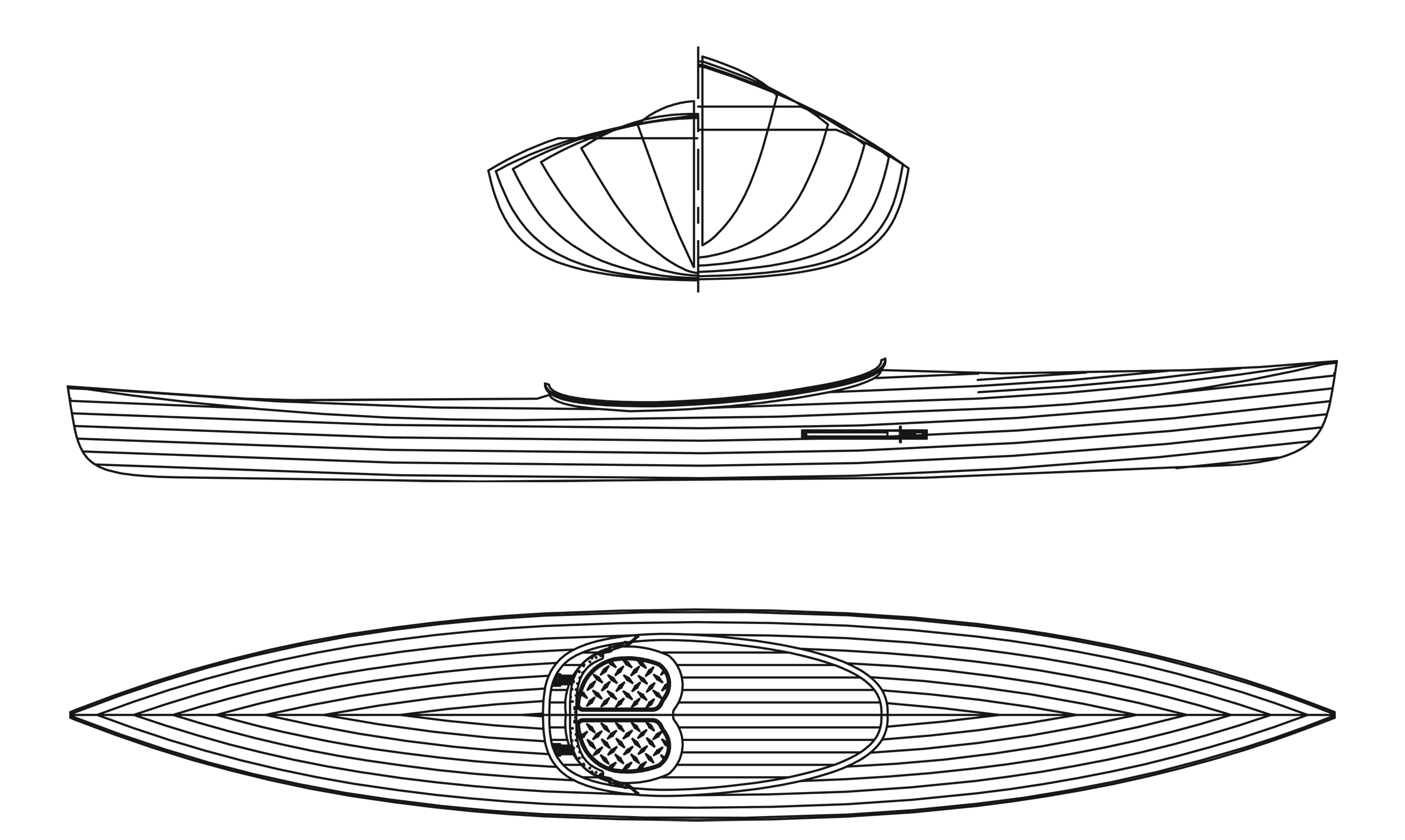
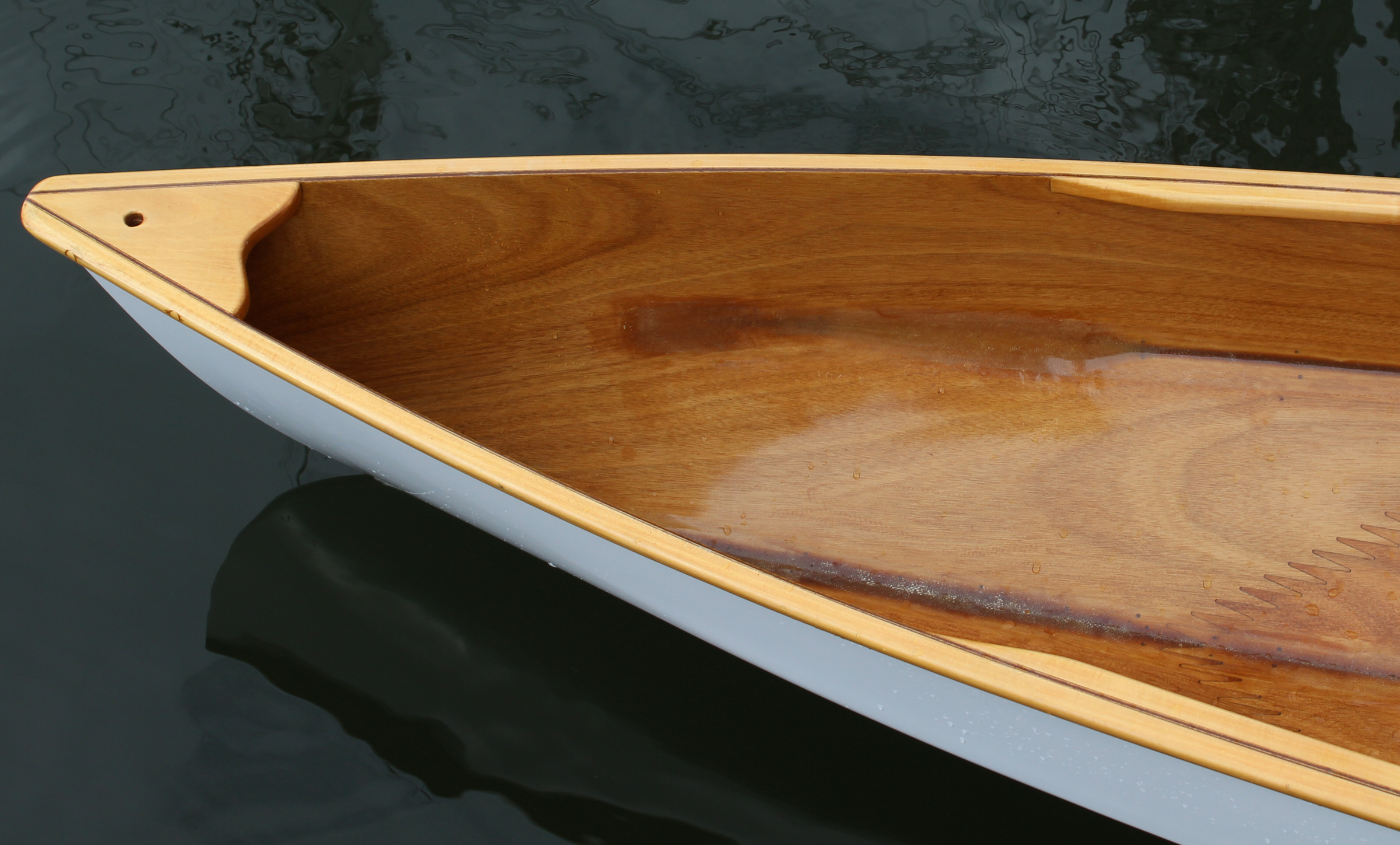
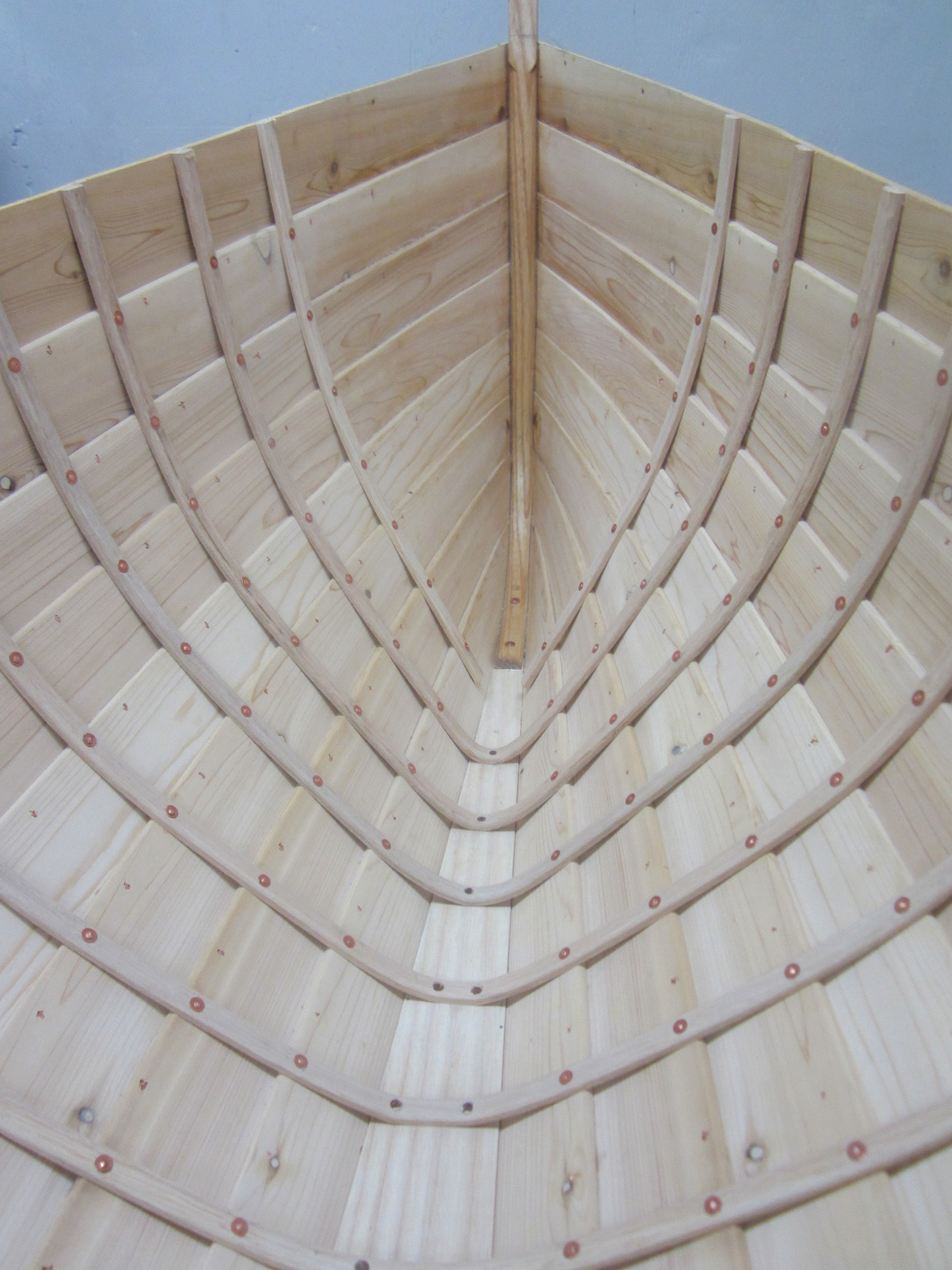
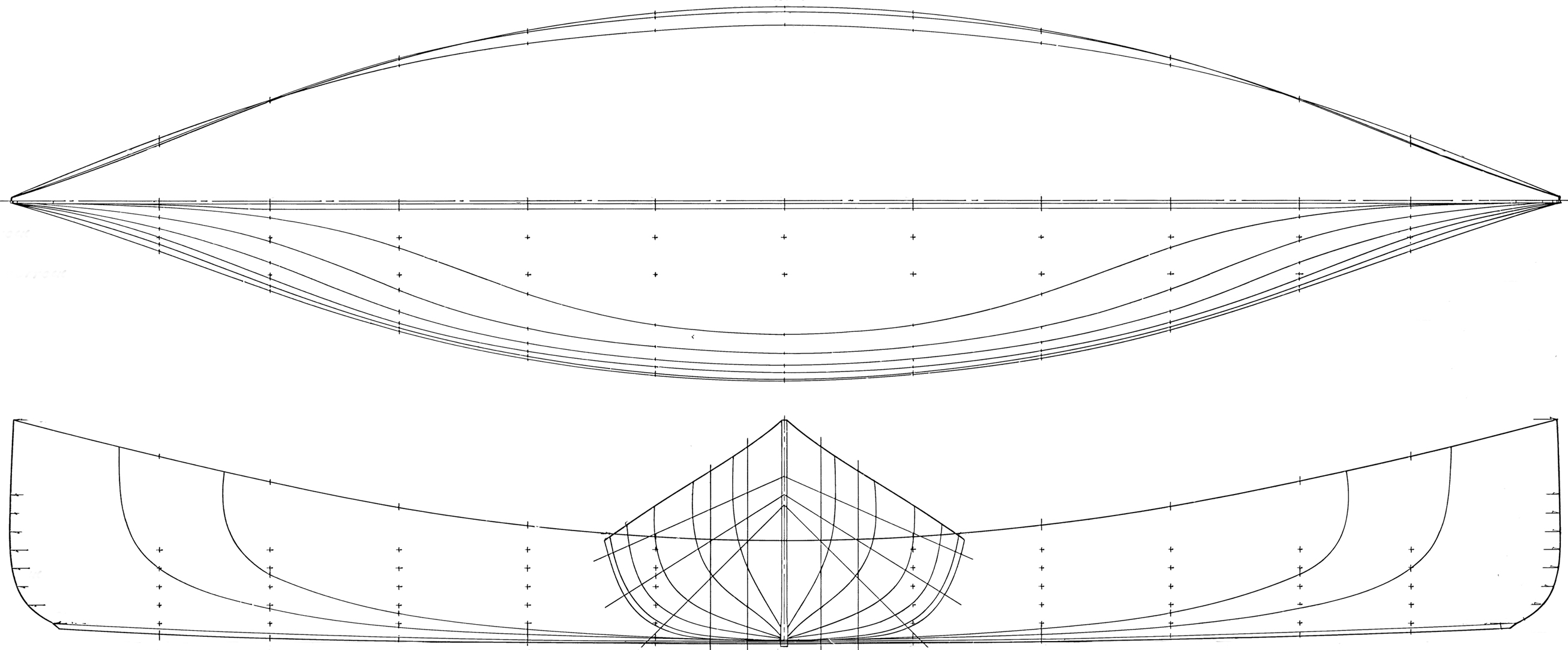
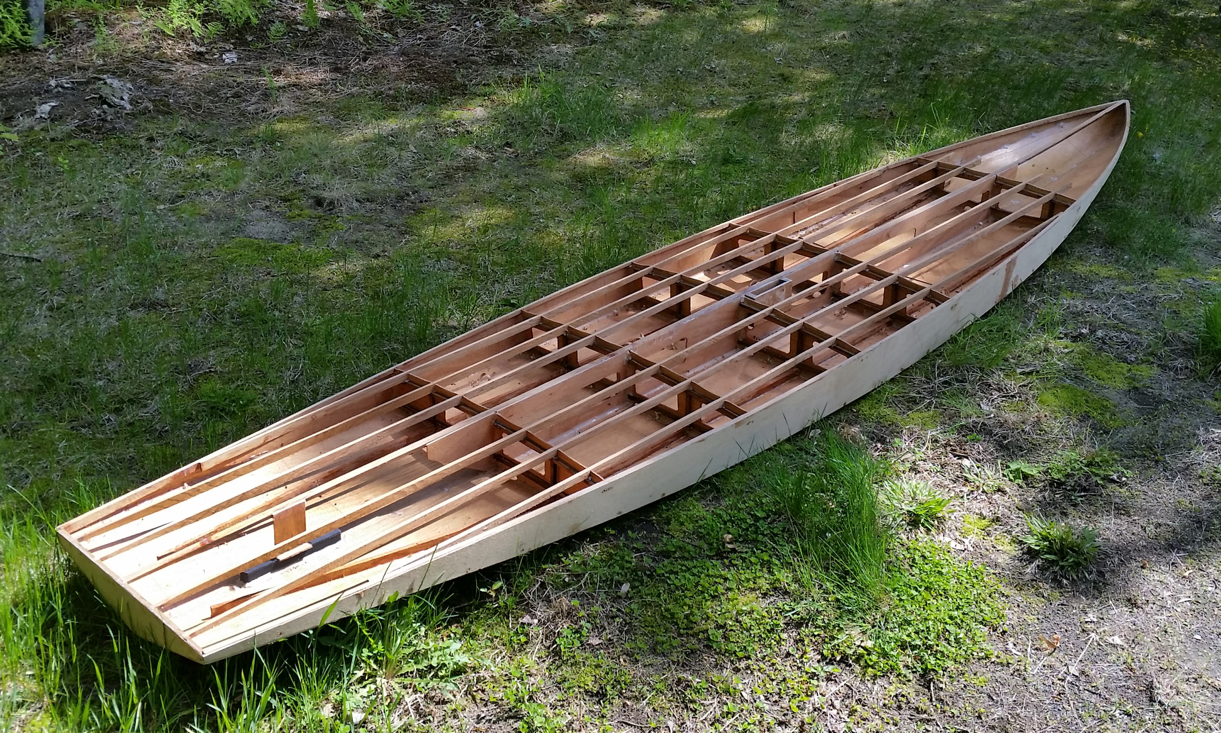
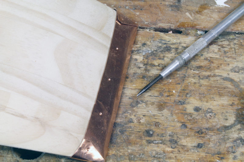
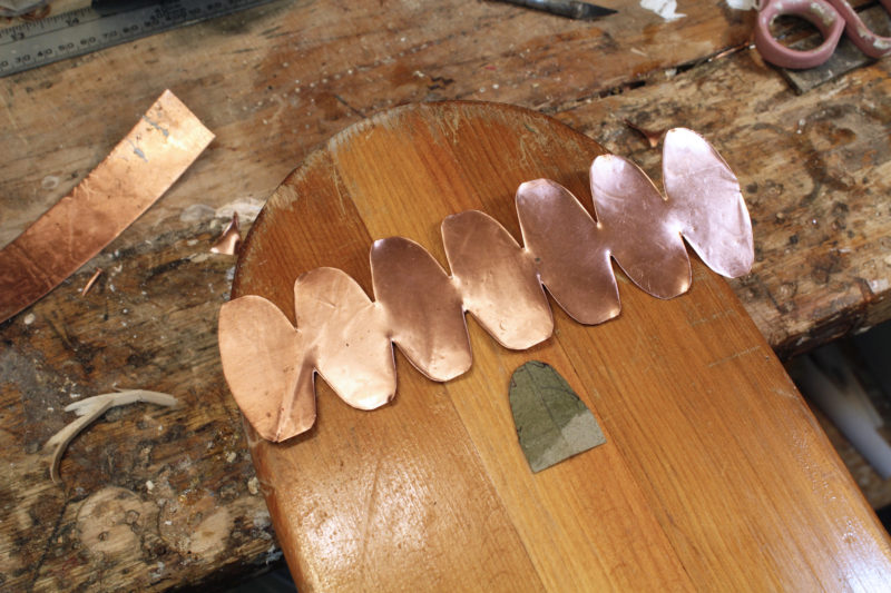
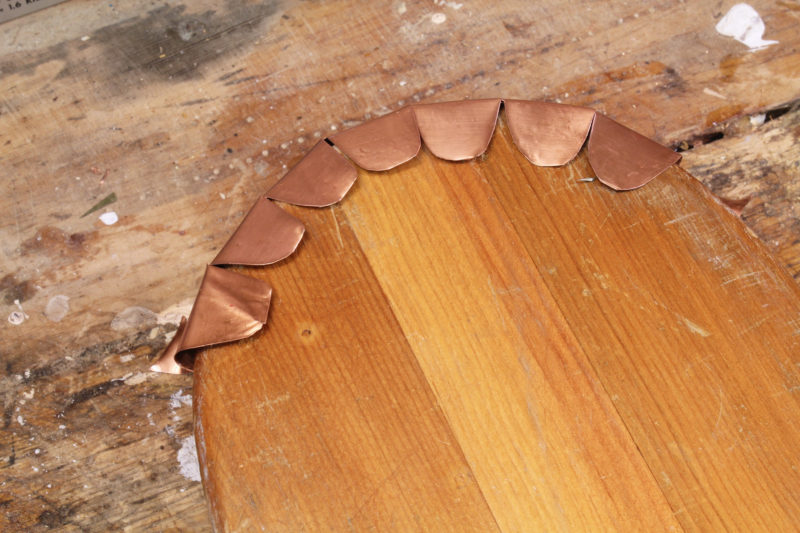
The Newfound Ladder-LOC Strongback system of brackets and forms was easy and straightforward to assemble—just center each form and square up. The forms are precision-cut from MDF (medium-density fiberboard) on a CNC machine and milled with a slot in the perimeter for clamps, so the boat is stripped without using staples. To me, the finished boat looks much nicer without staple holes.
I wanted full-length strips for appearance’s sake—there would be no joints on the finished boat—and to eliminate spending time to scarf-join every strip. I also ordered extra strips to cover anticipated mistakes. I purchased many of the tools and supplies that I needed from Newfound. Rose and Alan have simply been great folks to work with: always available by phone to discuss concerns, answer questions, offer great advice, and happy to share their knowledge and experience. They’re an invaluable resource for a novice builder.
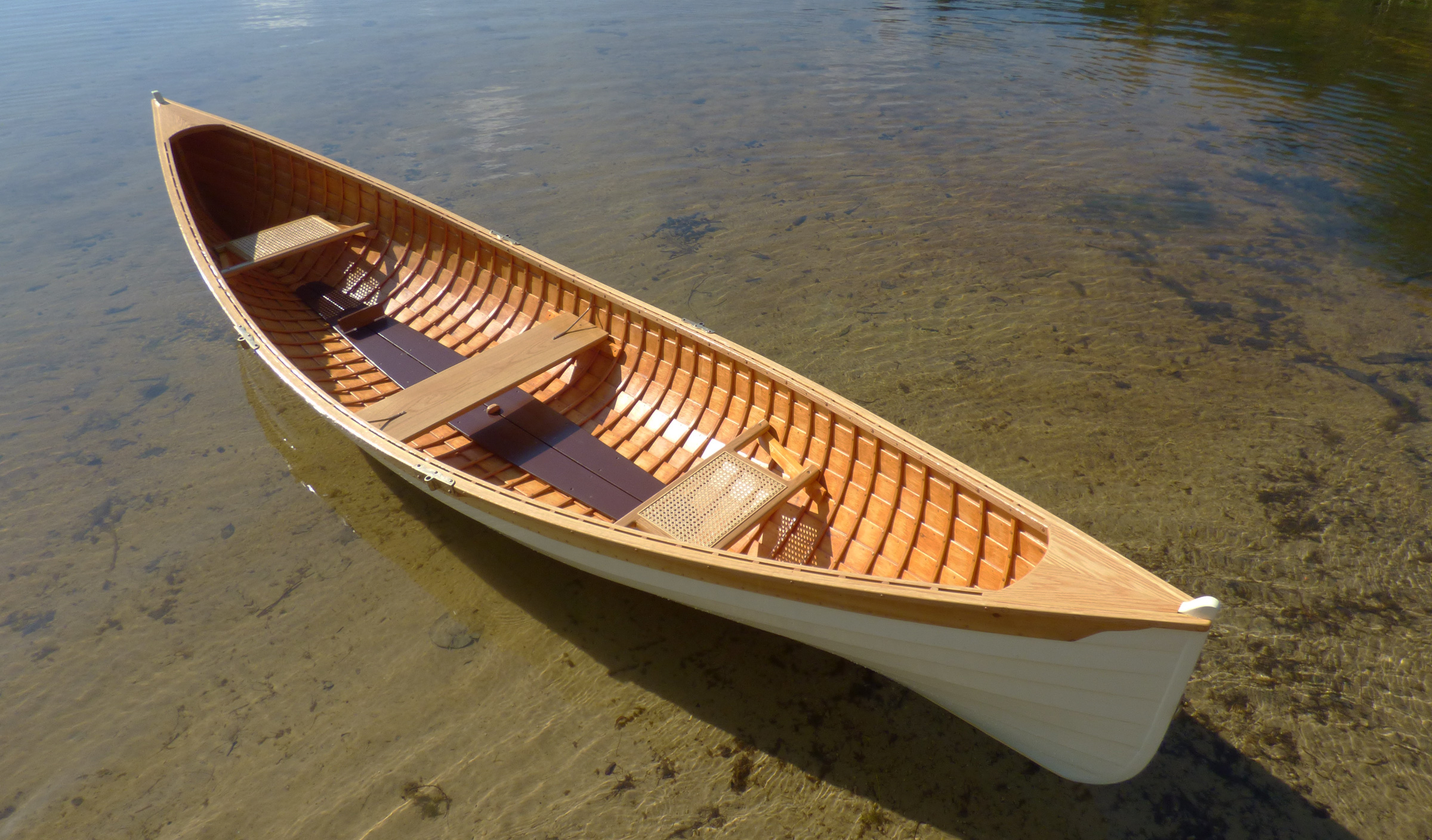
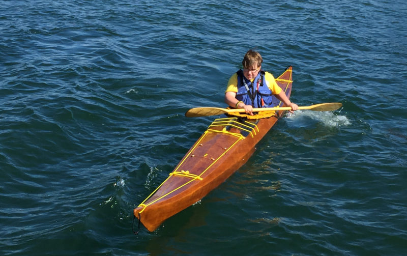
With an overall length of 12′ 8″, the Excursion is not designed for a high top-end speed, but with its light weight it is quick to accelerate and carries satisfying speed.
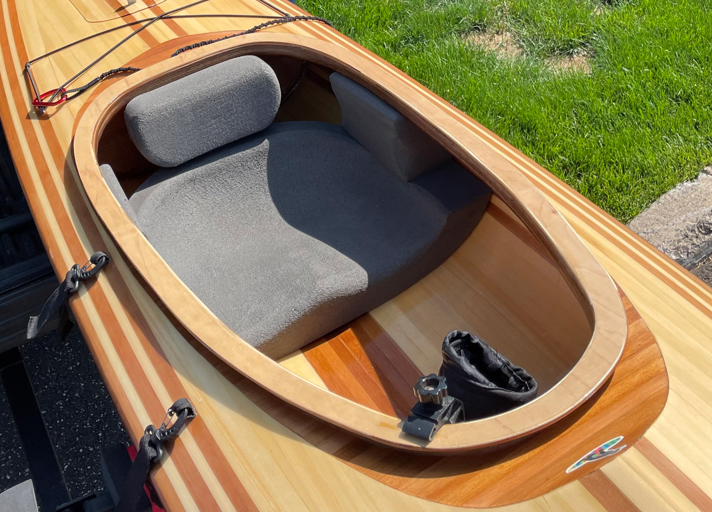
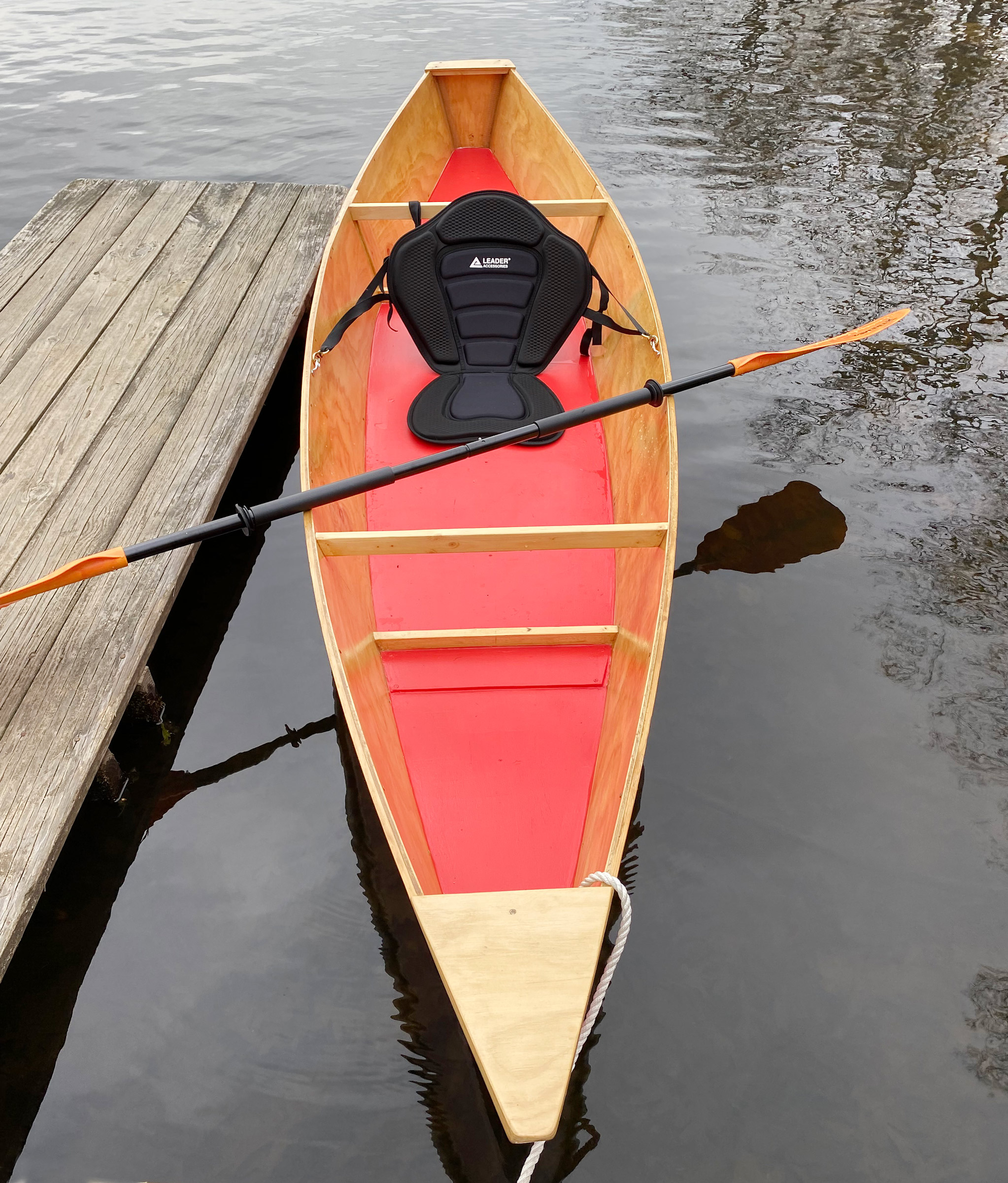
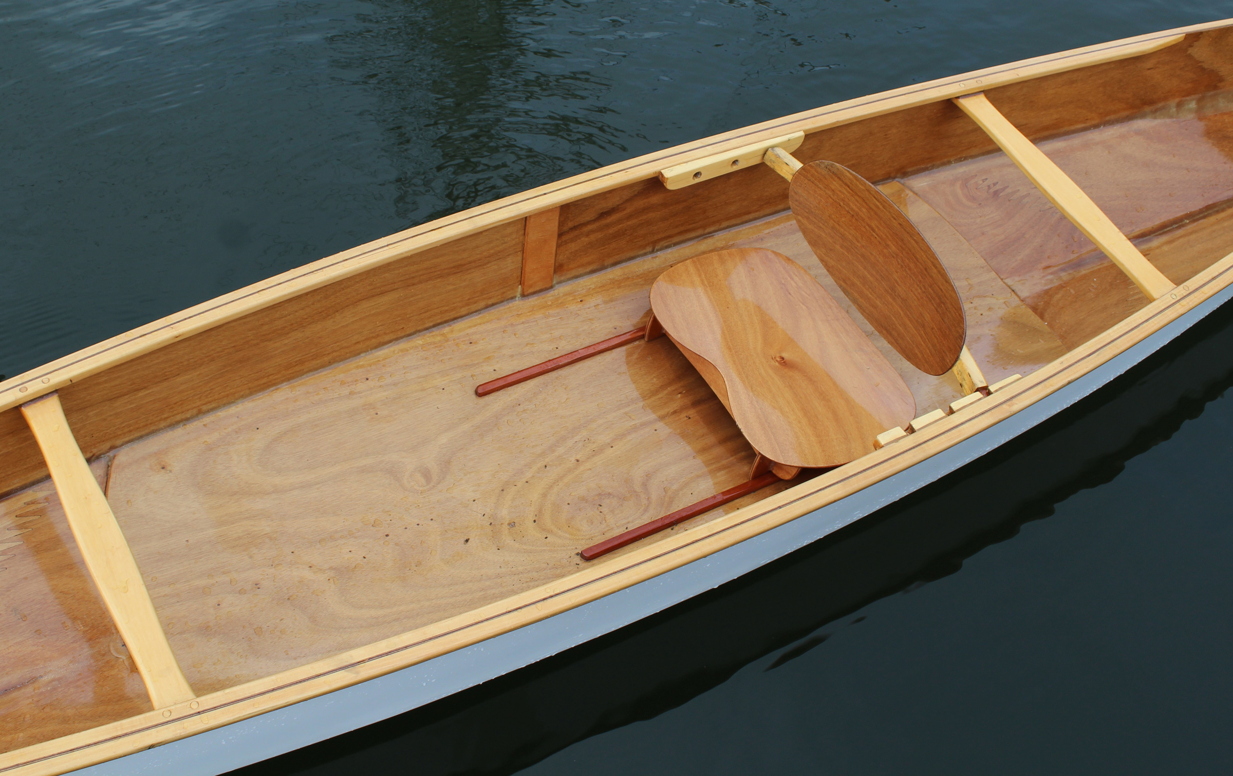
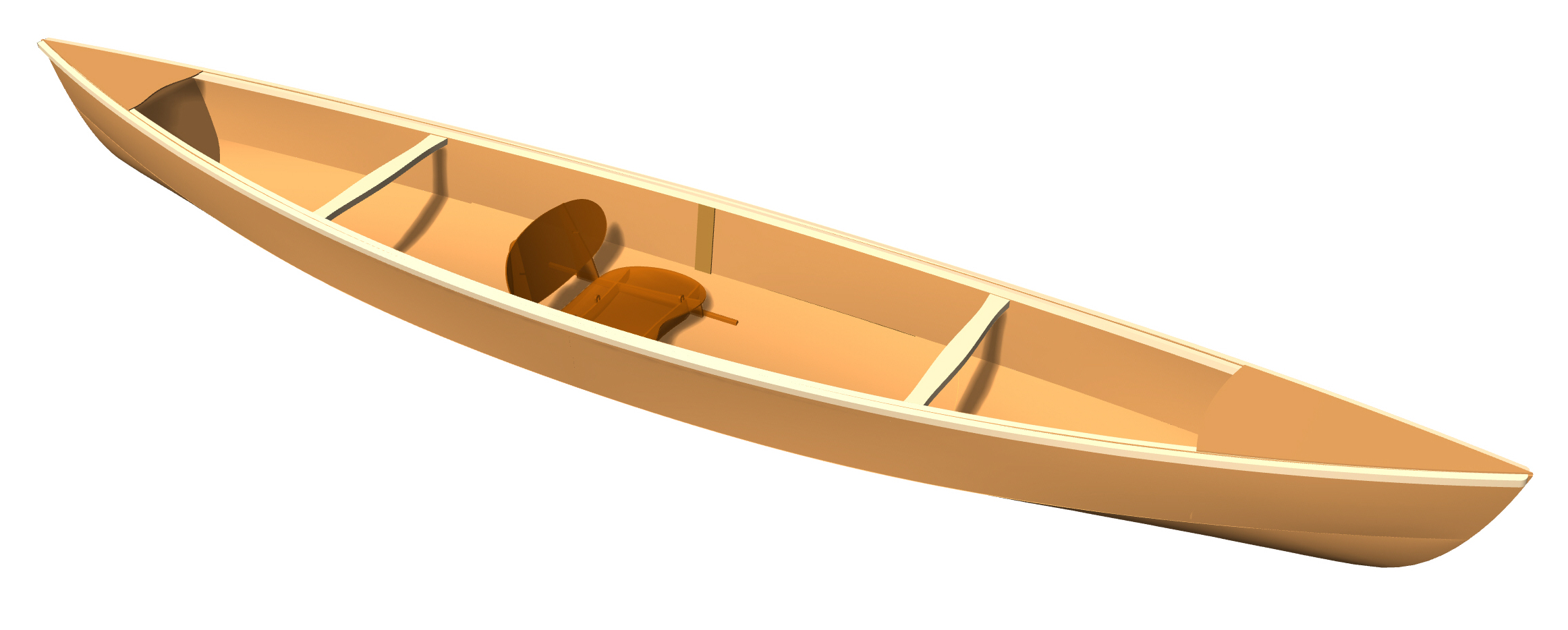
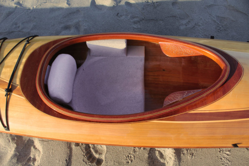
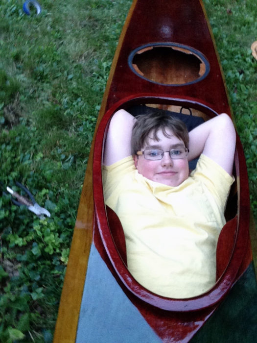
For the most part, I stayed true to the Excursion design and did not modify the hull. I deepened the recess for the cockpit coaming by a couple of inches for ease of entry and exit. The cockpit is now large enough that I can bring my feet and legs out and recline in my seat with my feet up on the front deck and my head resting on a rolled towel on the rear deck just behind the cockpit. My foredeck is a bit more peaked than designed—an unintended amateur mistake on my part—but it made it a little roomier under the deck for my cooler bag and I can stretch my legs out. I used magnets in the hatch coaming and flush-mounted the hatch cover to minimize deck hardware and keep the deck as clean and open-looking as possible. The rear bulkhead is marine mahogany plywood, supplied with the kit, but I omitted the front bulkhead for extra legroom and open storage under the foredeck. I can add inflatable float bags when needed
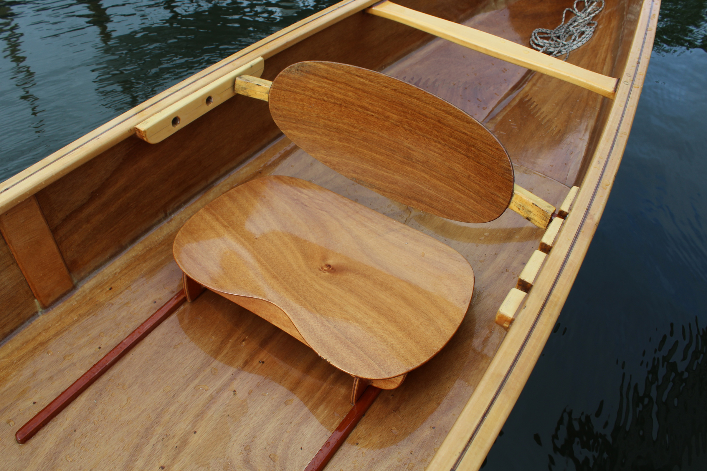
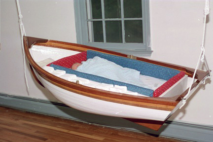
The kit package includes a mini-cell seat bottom pad and a back band, which is mounted to the cockpit coaming, but I wanted a one-piece seat and minimal hardware. I researched various seats and back band combinations but did not find anything on the market that I really liked. However, Redfish Kayaks offers custom seats made from a few pieces of minicell foam glued together and shaped to fit. Its molded sides and good backrest eliminate the need for a separate back band and hip braces. I have not added thigh braces under the deck. The seat is comfortable to sit in for hours on the water and is easy to clean and maintain. It easily pops in and out of the kayak when I want to hose off and wipe down the boat after use.
While the standard Excursion kit includes a seat and back band, the author opted for a custom-made foam seat from Redfish Kayaks. The cockpit coaming will hold the optional Newfound Woodworks spray skirt securely in place.
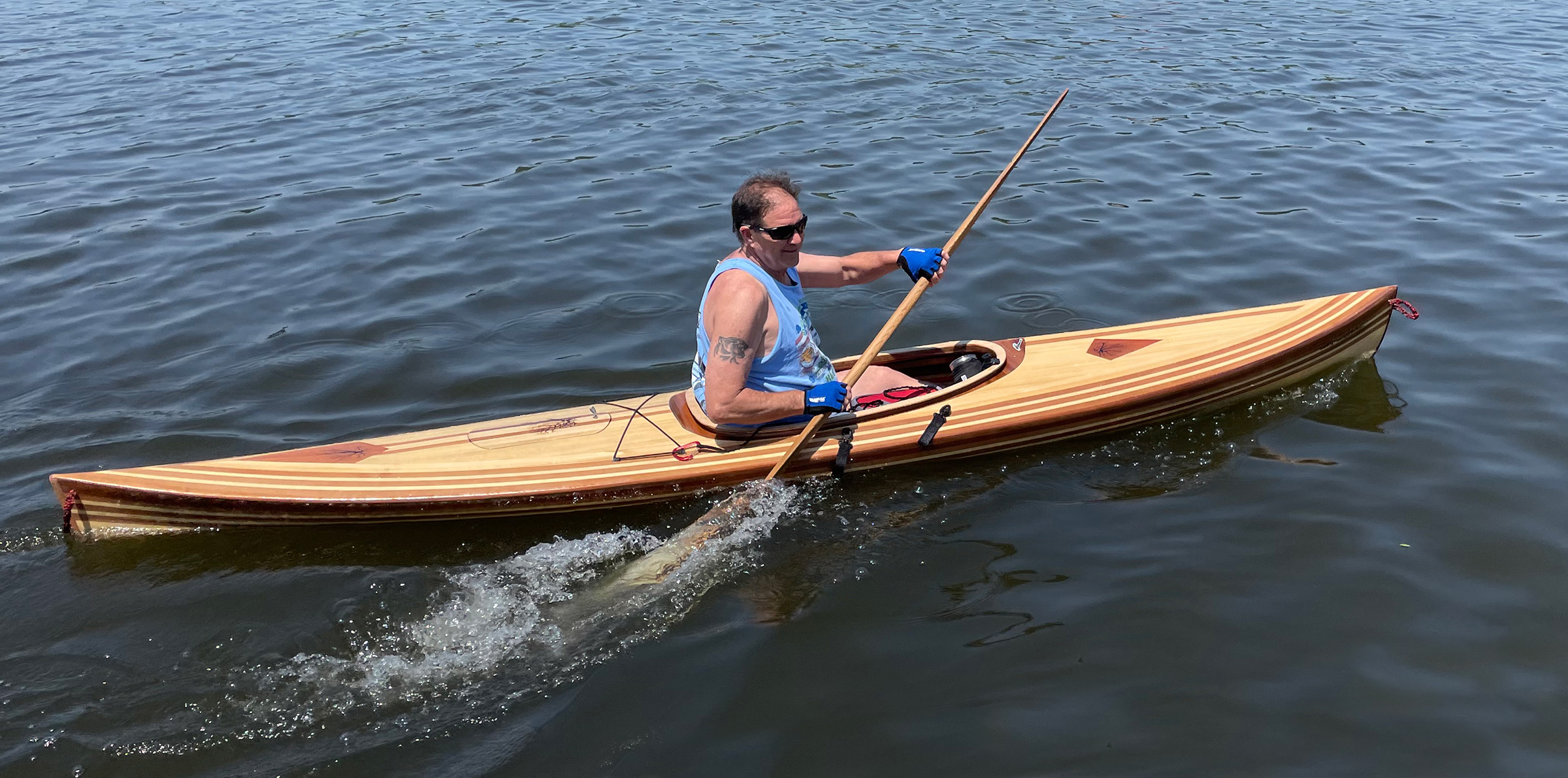
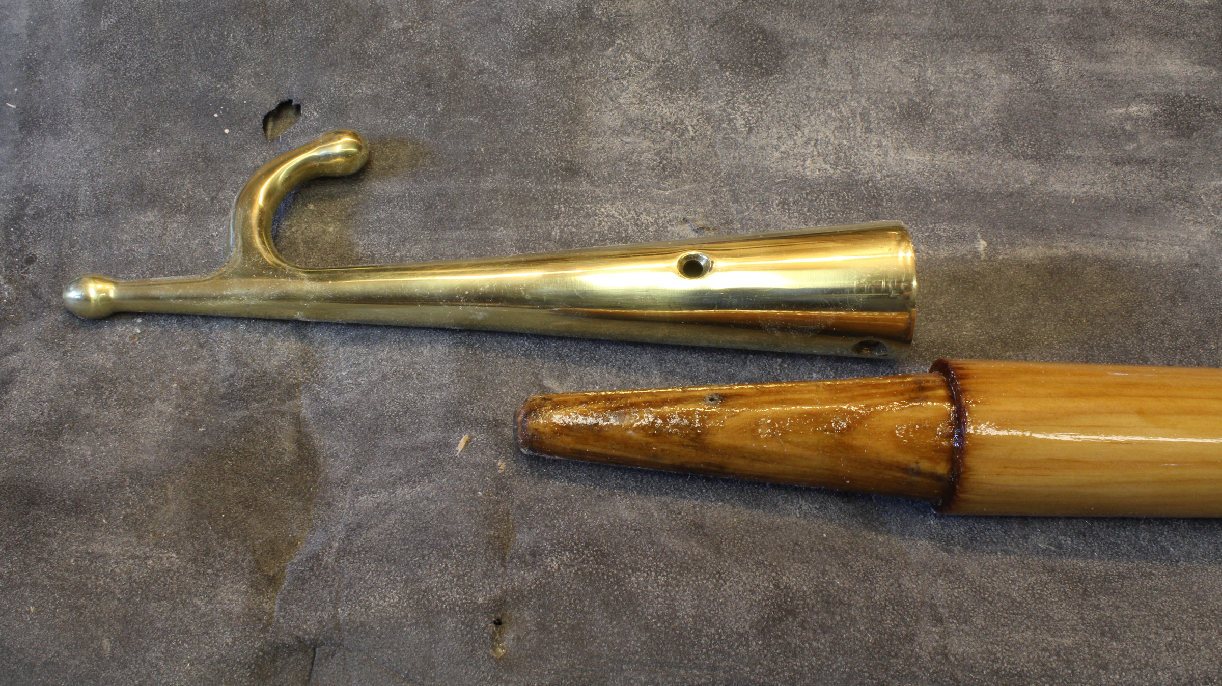
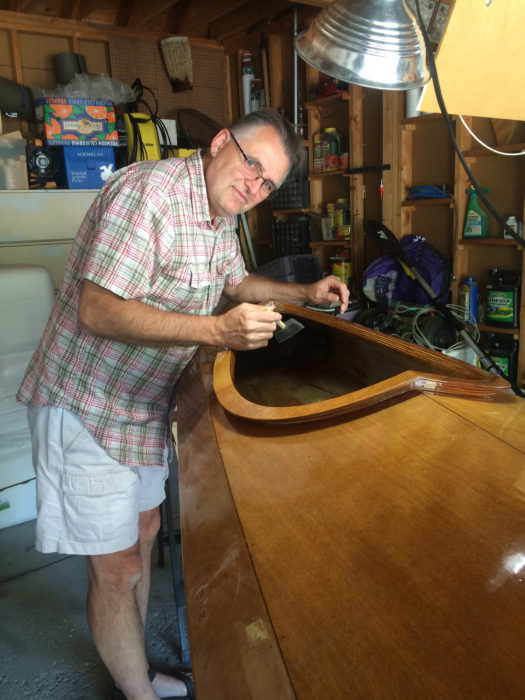
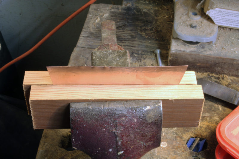
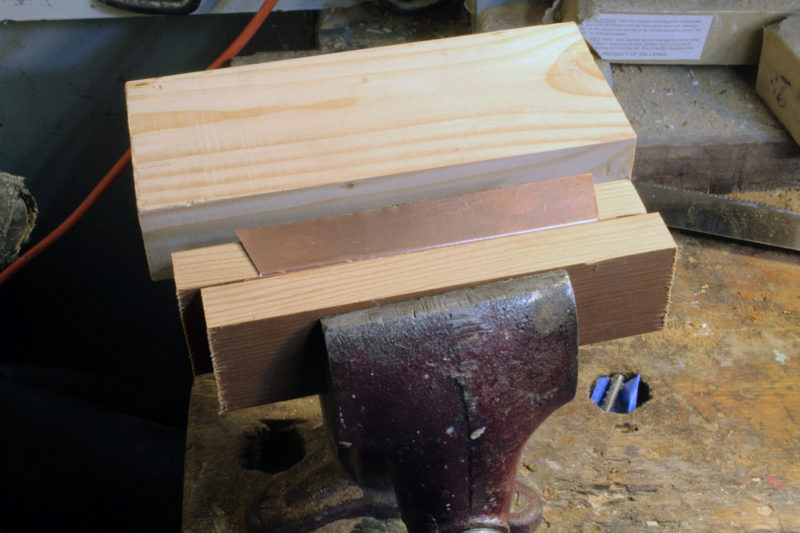
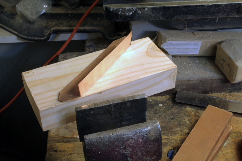
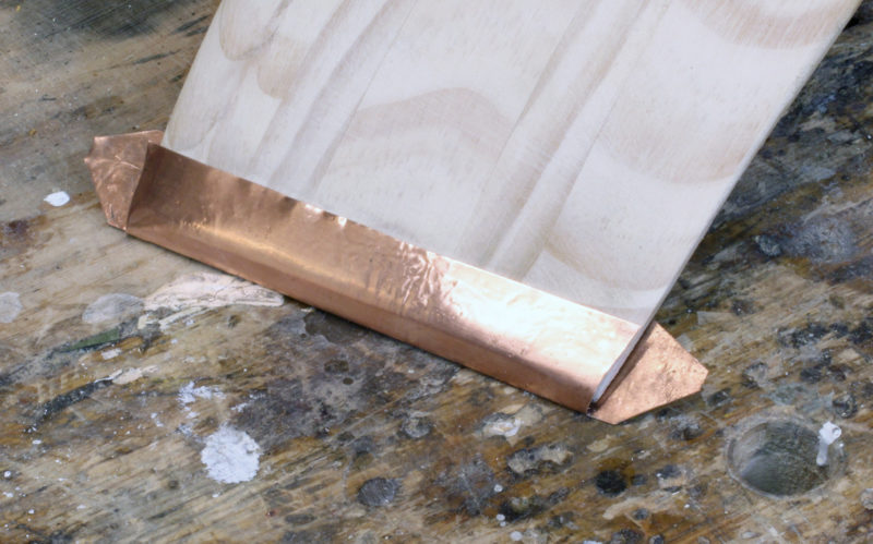
I added several types of wood as accent and trim pieces, including a nice piece of curly maple plywood for the cockpit coaming, teak veneers for the hatch lip coaming, and Spanish cedar pieces for inlays that I decorated with high-voltage electrical-current burn patterns (see LAZY LIGHTNING). The bow stem is western red cedar and the stern stem is red oak.
With the Newfound Woodworks construction system, the strips are held to the molds with clamps rather than staples, so the finished kayak isn’t marred by speckled bands of staple holes.
The kit kayak as designed should weigh around 36 lbs, but with extra layers of ’glass on the hull bottom and stems, my finished boat is about 44 lbs.
I use my pickup truck to transport the Excursion and can load and offload it by myself, but it is easier to handle with someone to help. I have never had to portage over distances or obstacles, but the kayak is easy to balance on my shoulder and solo carries over short distances are no problem.
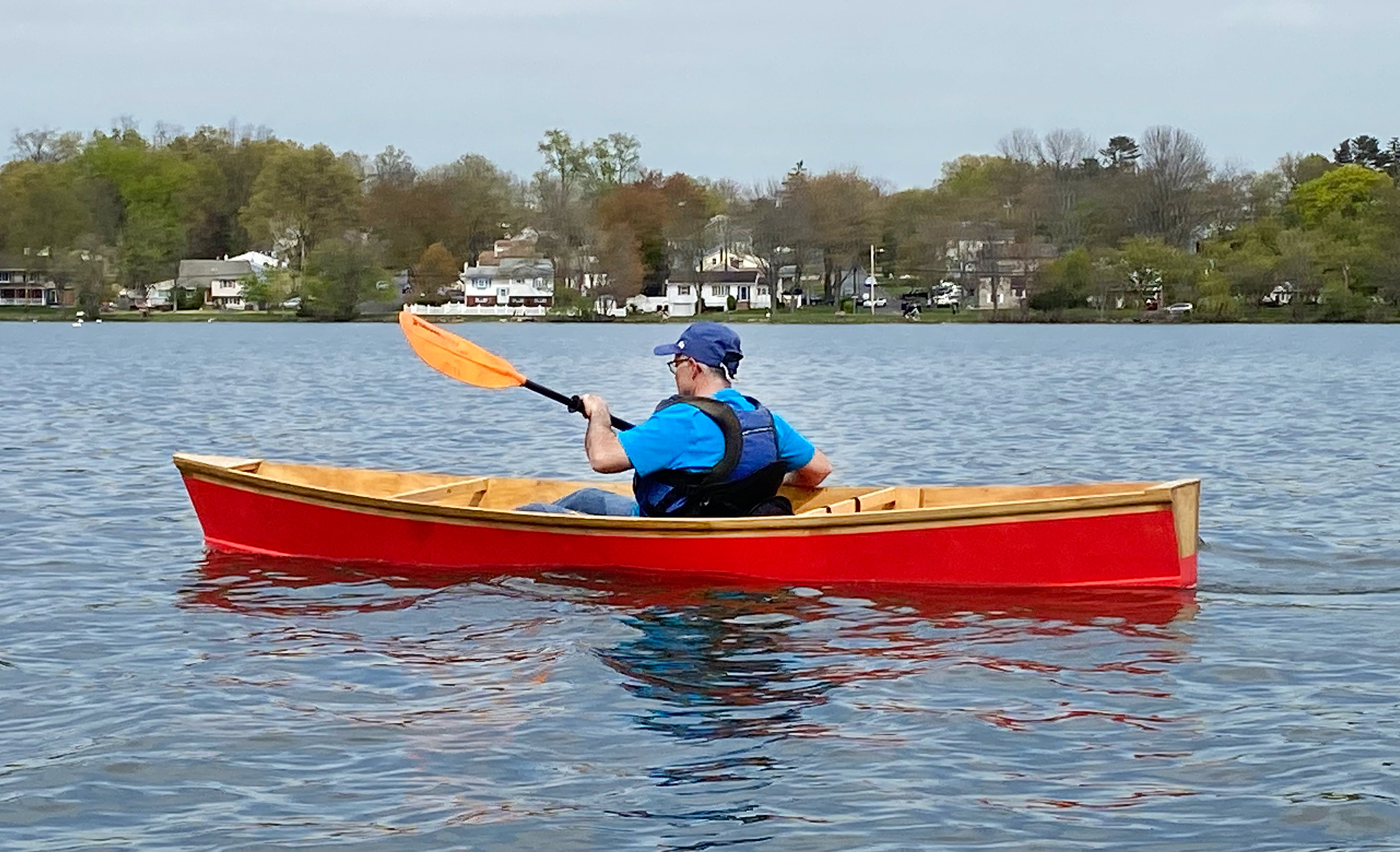
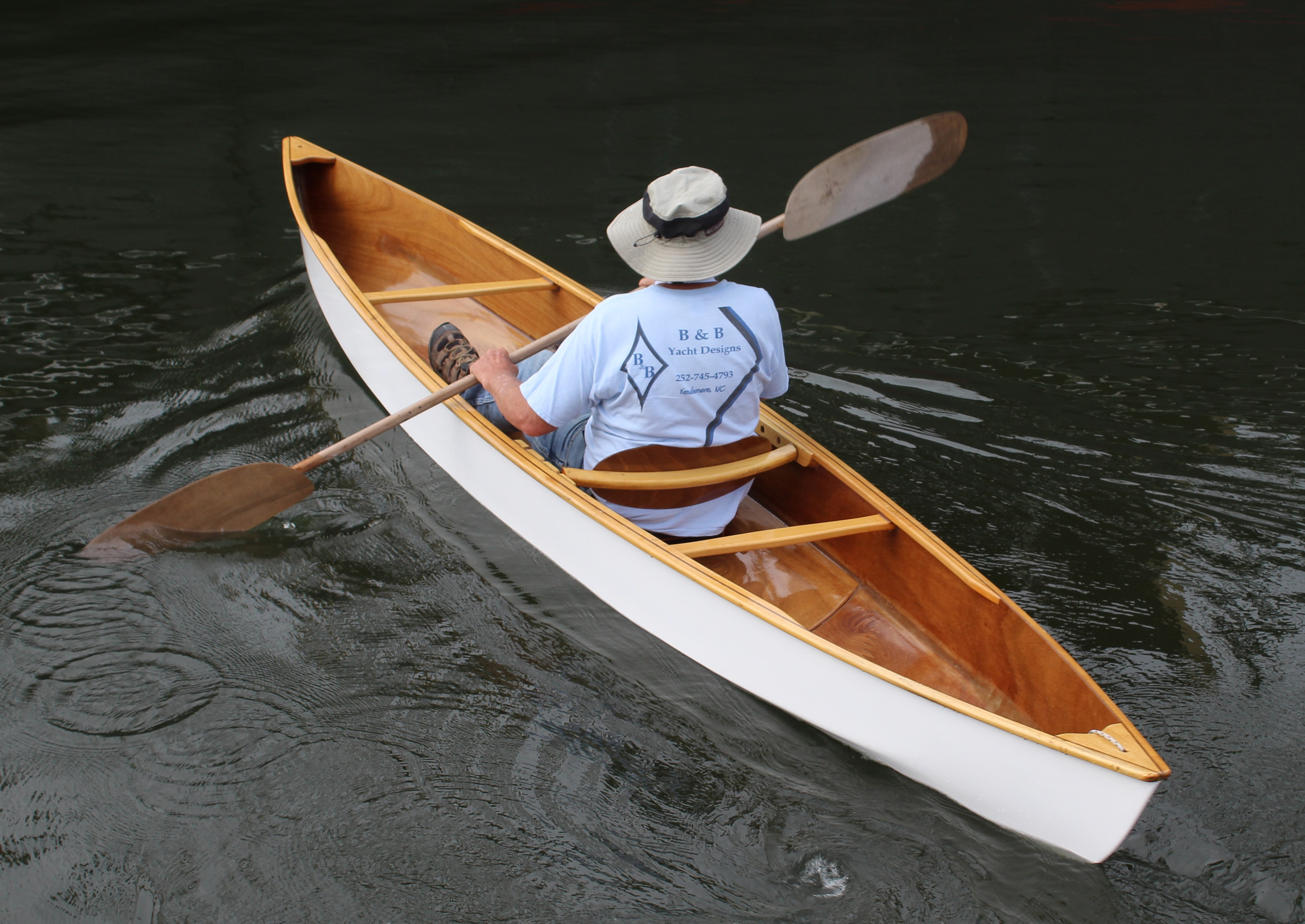
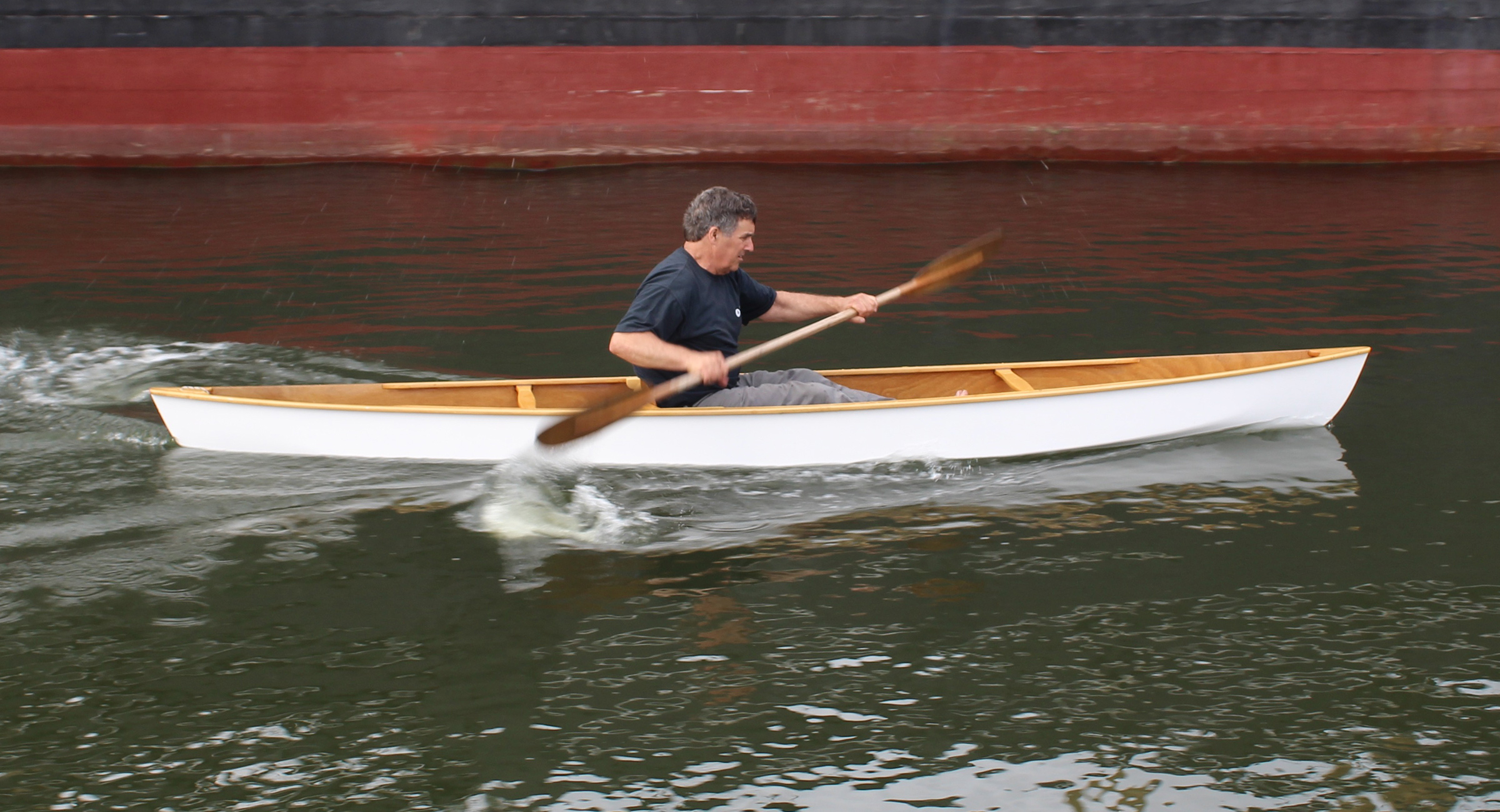
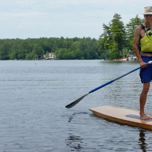
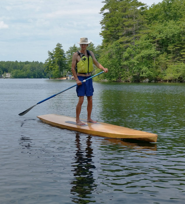
The 36″ × 17″ cockpit opening is large and the Excursion has a 24″ beam, making it easy to get in and out. The kayak is very stable and makes a good platform for fishing, photography, birdwatching…or just daydreaming and floating the afternoon away. The Excursion is fast and glides well; it’s a sports car compared to my 12′ 8″ rotomolded plastic kayak. It tracks nicely and handles a cross breeze well for a shorter boat. Newfound notes that the Excursion is “designed to be used in a recreational setting such as day trips on inland lakes and quiet water.” I would not choose to take it out in rough weather, but it does okay in a stiff breeze on the open water of my local lake (I have been out in swells and a couple of feet of chop, and the kayak rides nice and high).
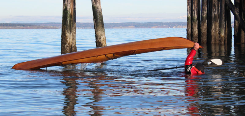
The Excursion has a long cockpit, and paddling without a spray skirt is appropriate for the quiet waters the kayak is designed for. While it has good stability, in the event of a capsize, the large opening makes it easy to exit the cockpit.
I cannot speak to rolling, self-rescue, or wet exit as I have no experience with these maneuvers. As a 60-year-old man, I am strictly a lazy-day-on-the-water paddler and too old for rough water, rapids, or whitewater. More important, I don’t want to bang up my boat, so—no rocky streams.
The whole experience of building the Excursion was interesting, enjoyable, and I couldn’t be happier with how it turned out. The custom kit package enabled me, a complete novice, to build a beautiful recreational kayak that I am proud of and will be happy to paddle for years to come.
A Philadelphia kid at heart, Dave Feder discovered his love of water while spending childhood summers at the Jersey shore and as a young sailor in the U.S. Navy. He has been a recreational kayaker most of his adult life. An electrical engineer by profession, he also enjoys hiking and trail-walking with his dog and playing with his grandkids. In his spare time, he is an amateur woodworker. Building his own boat was a longtime dream.
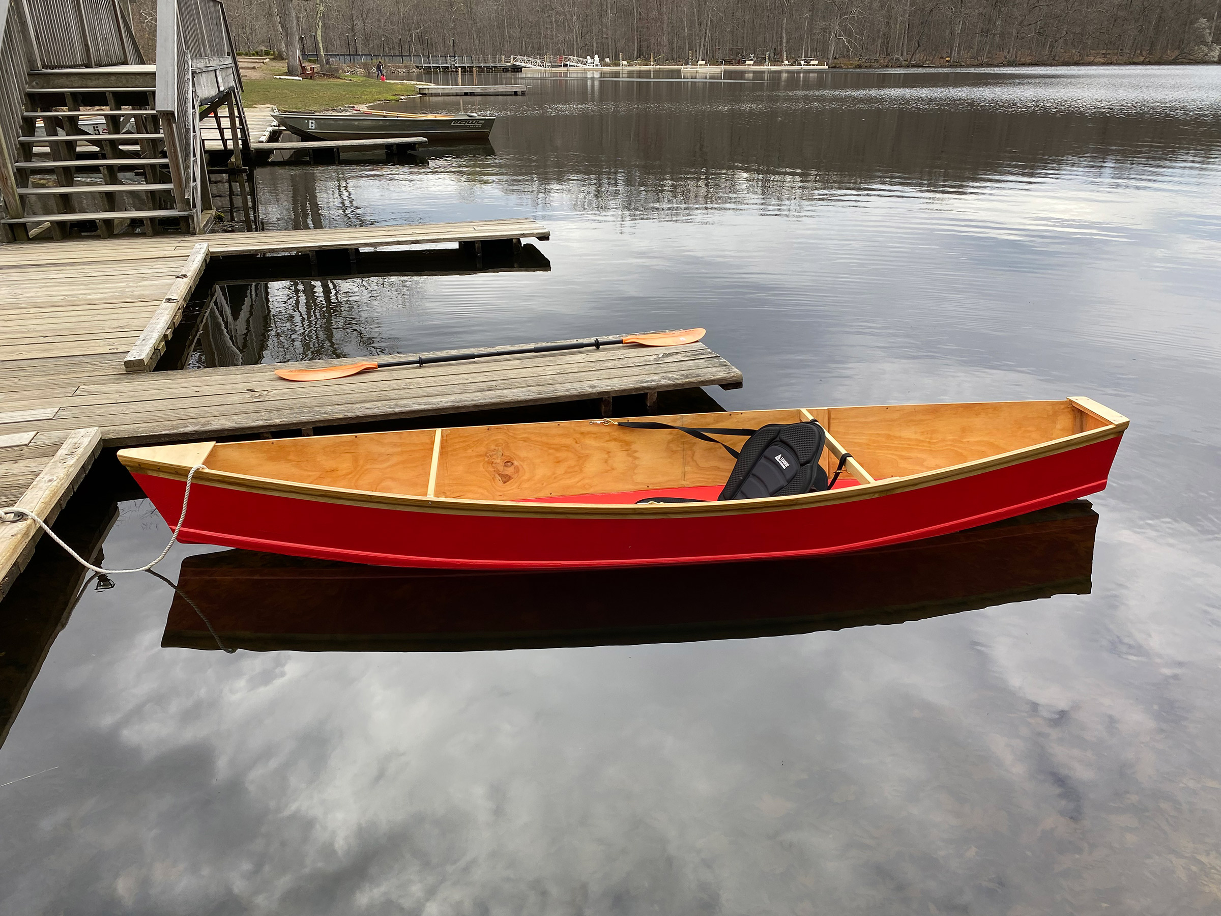
Joe Lanni’s first-build, 3’S A CROWD, appeared here as the Reader Built Boat for our September 2020 issue. She’s a three-piece plywood sectional, built to plans that provided the option to forgo curves. That simple construction appealed to Joe as a novice boatbuilder, but a boat constructed with straight lines, angular corners, and flat surfaces might not be regarded as a first step into the boatbuilding arts. “It was,” writes Joe, “like making three wood boxes that connect.”
There are three good reasons for a boat to be, instead of boxy straight lines and angles, a composition of curves flowing one into another: even a quick glance at any creature evolved to move quickly through water makes it obvious that smooth curves don’t impede its flow; the curves of a hull, like the arch in stone and steel architecture, have more strength than straight lines; and curves are simply more beautiful.
Photographs by and courtesy of Joe Lanni
With Joe’s first boat, there were valid practical reasons for building it with the sheerline made of straight segments, but one’s eye cannot follow it without coming to a stop at the angles created.
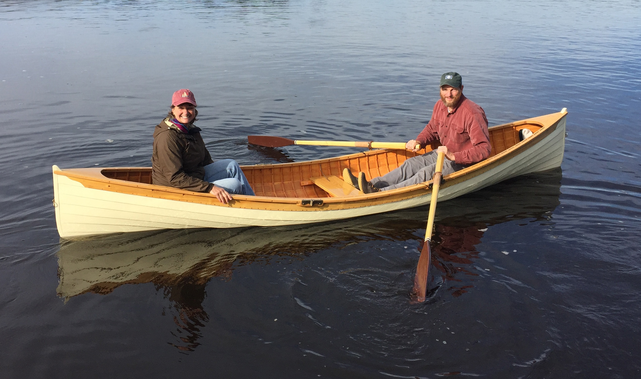
For his second boat, Joe was interested in another easily built plywood boat, this time a kayak or double-paddle canoe around 11′ long and light enough to be easily cartopped. He liked the look of Wee Lassie canoes but wasn’t ready to take on the traditional cedar-on-oak lapstrake construction. His online search led him to the Wacky Lassie, which designer Fritz Funk describes as “an instant double paddle canoe to be built and used by kids.” Joe finally settled on the Wackless Lassie, David Beede’s take on Fritz’s boat.
David’s website provides a guide to each step in the construction and measured drawings for the plywood pieces and the temporary forms. The 10′9″-long sides, cut from 1/4″ plywood and each butt-blocked from two pieces, are straight and parallel sided. The sides’ straight lines get their curves from the spread and the angle set by the temporary forms. The chine logs, as well as the outwales, are glued on the outside of the side panels. Having the chine logs on the outside makes them easier to bevel to provide a landing for the bottom—just glue them along the edge of the plywood and plane the proud corners flat after the sides are bent around the forms. The bottom gets a keel, glued on the flat, and, after the three forms are removed, two spreaders hold the sides out.
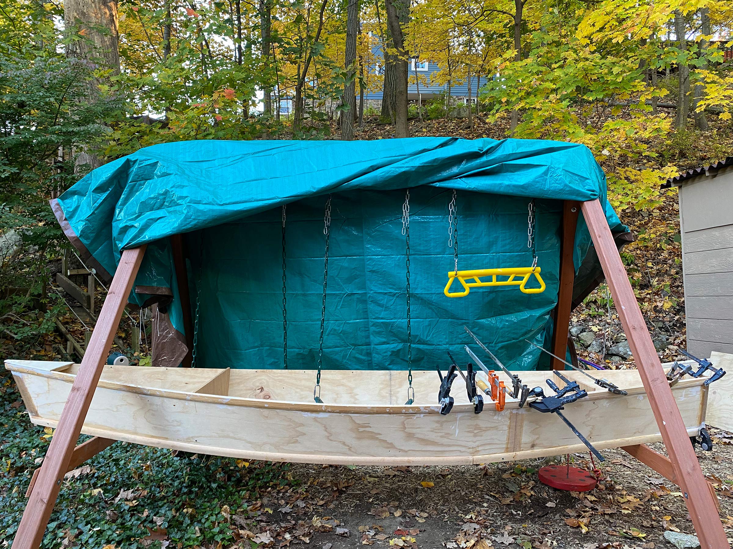
When it came to build an 11′ boat that was too big for the workshop, it was Daddy’s turn to use the swing set.
Joe made his Lassie in his yard using his kids’ swing set as his workshop. The only shelter the boat had from the weather while under construction was a tarp. The project sat idle for weeks at a time during the New Jersey winter.
The finished canoe belies the fact that its sides can be cut in a single pass on a table saw with its fence set 11″ from the blade.
The finished Lassie came in under 40 lbs. For the accommodations, Joe uses a sit-on-top seat/back support with fittings on the rail to hold it upright and in place. He finds the canoe “easy to paddle; it tracks really well and is a joy to use.” It hasn’t yet been christened, but the name he has in mind (another inspired by the passenger capacity) is PARTY OF ONE.
A sit-on-top kayak seat and backrest provide simple but comfortable accommodations.
The curve of the port rail, deepened by this view, invites the eye to swing back and forth like a slow pendulum. Even while the canoe is at rest, it invites motion.
The Wackless Lassie sits nicely in the water with the ends just touching the surface.
With a simple bend around angled forms, Joe transformed the ruler-straight sides of two pieces of plywood into an eye-pleasing sheerline. He has already been musing about building a third and larger boat. On the road he is traveling to become a boatbuilder, there are more curves ahead.
Do you have a boat with an interesting story? Please email us. We’d like to hear about it and share it with other Small Boats Magazine readers.
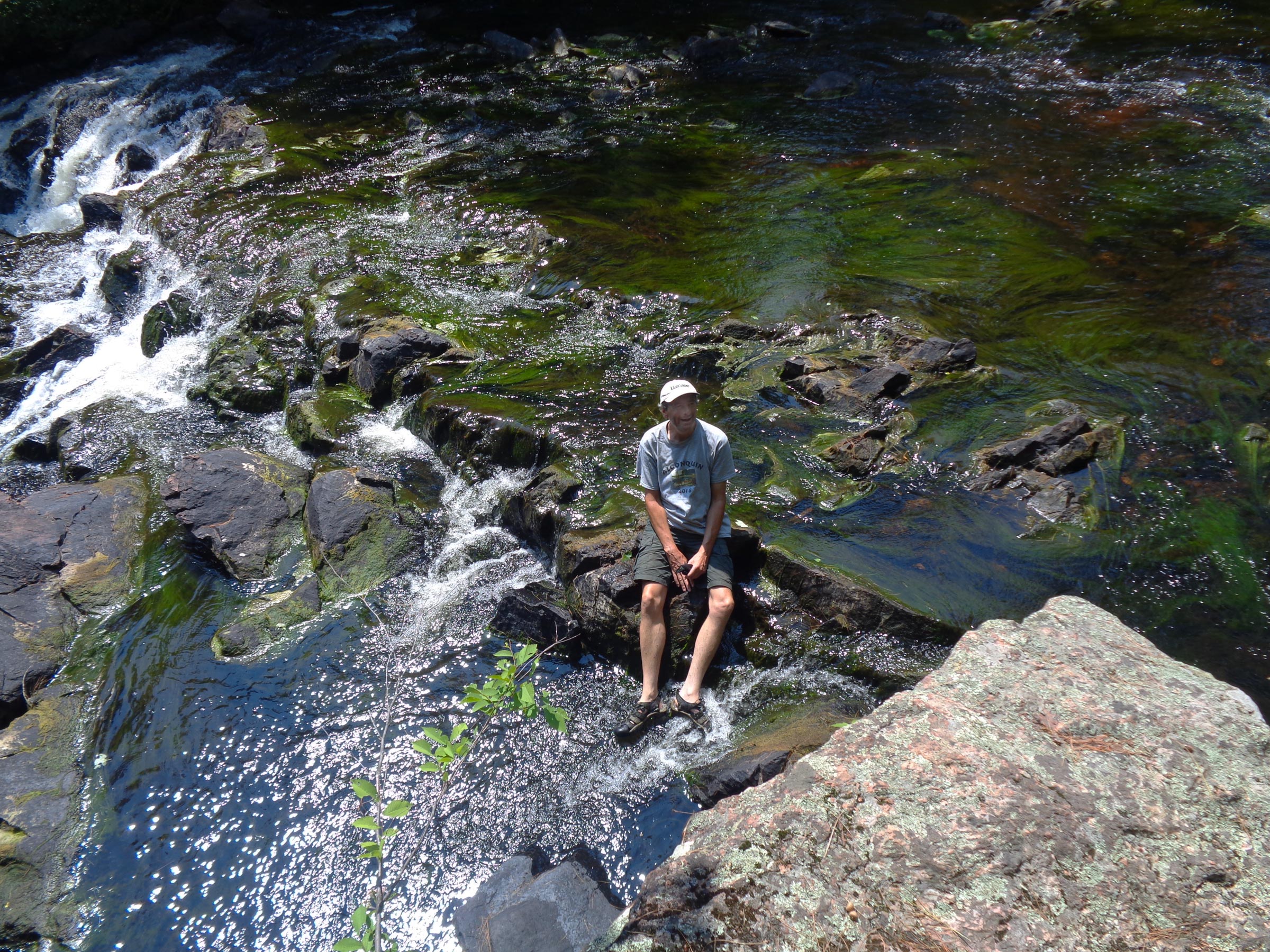
We descended the steep trail from the parking lot into the Barron River valley and came into a grove of pine trees with waist-thick trunks; their roots fanned out more than 20′ and intertwined above the shallow soil. At the river’s edge was a clearing carpeted in russet pine needles. The banks were lined with rounded barrel-sized boulders, and rocks just below the surface of the water had a copper-colored glow. Where the 50′-wide river was deepest it ran black.
Photographs by the author
After carrying the canoes down from the long, steep path from the Brigham Lake parking lot, Phil and Rob paused for a rest before launching onto the Barron River. Two paddlers who preceded us are just getting underway.
The sun was high overhead and the heat of the day was peaking. Sweat beaded on my brow, but waiting for us was a soothing breeze on the Barron River. I was headed, with Rob and Phil, my canoe buddies for many years, to a part of Ontario’s Algonquin Provincial Park known as Barron Canyon, where granite cliffs stretch 300’ above the river.
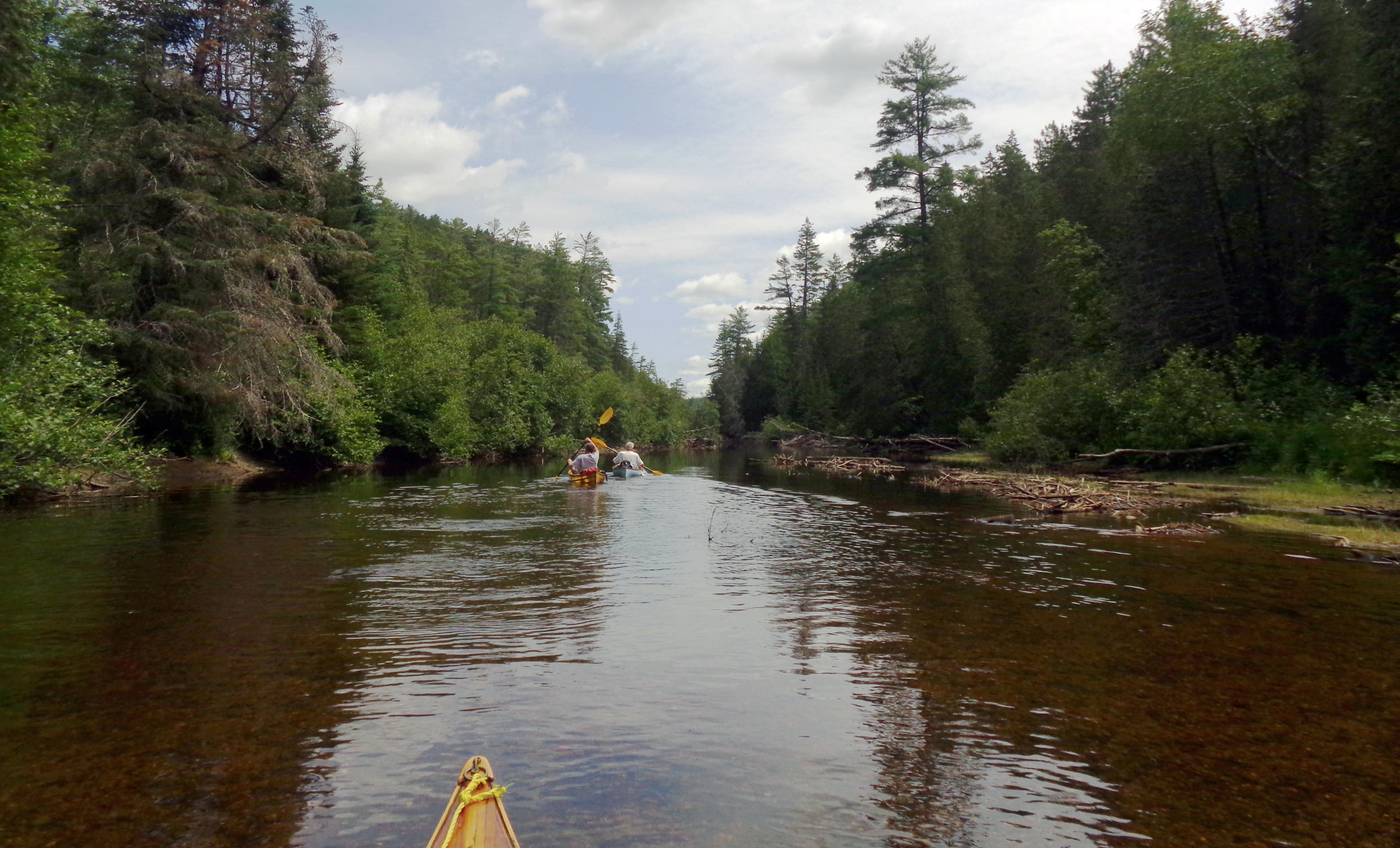
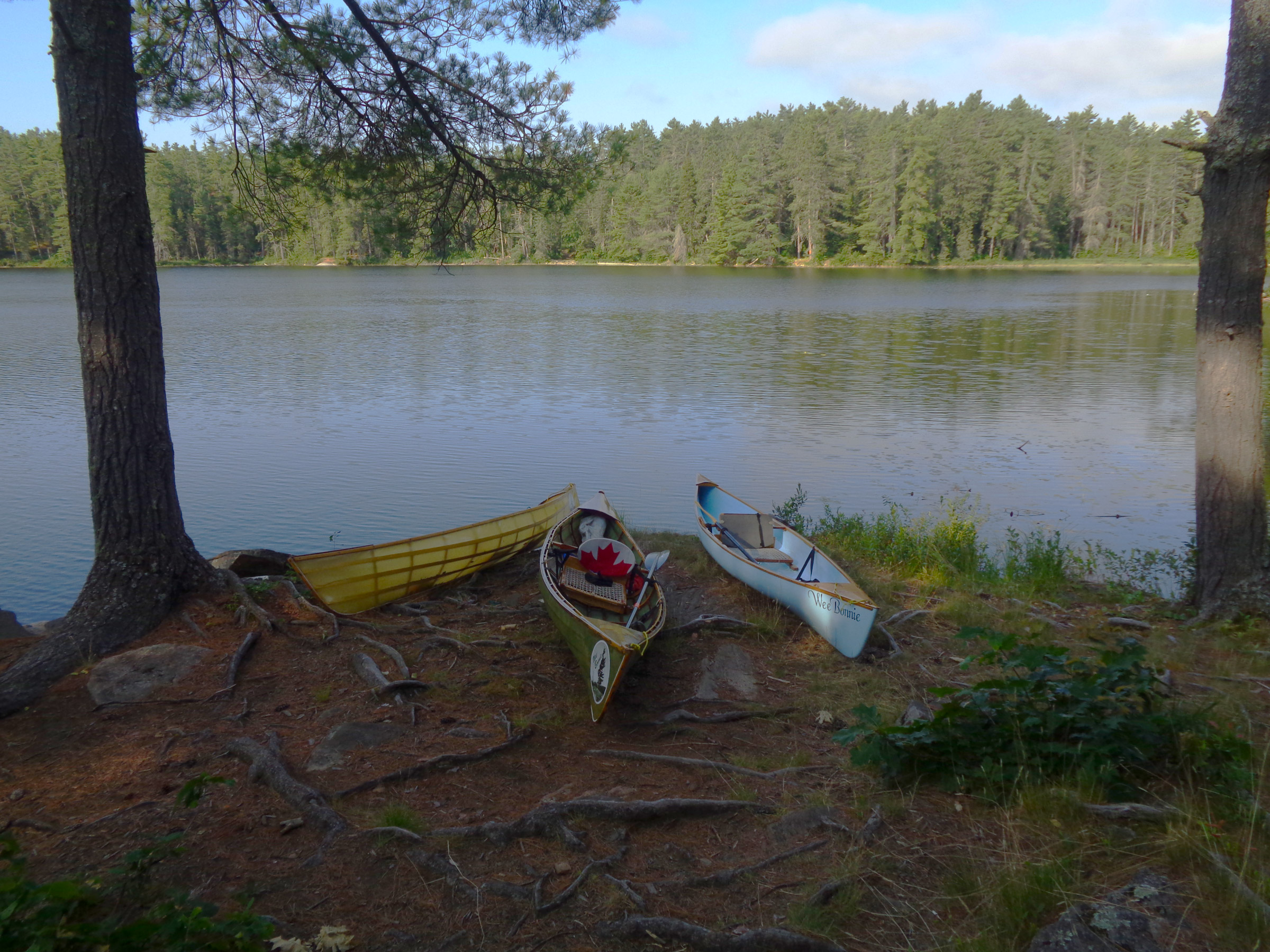
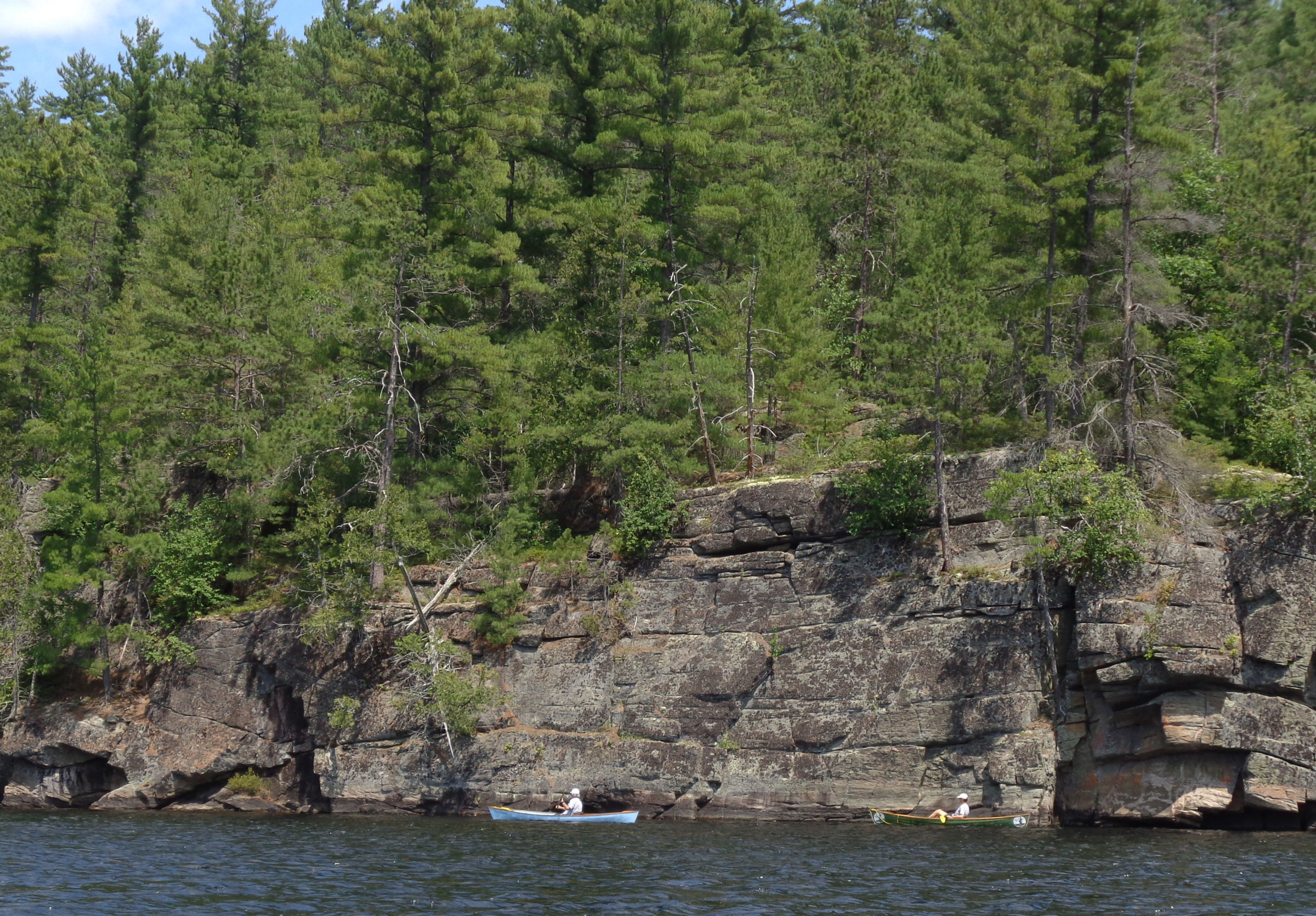
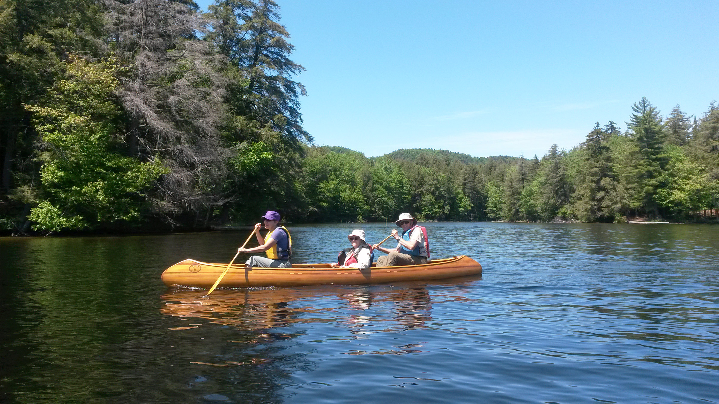
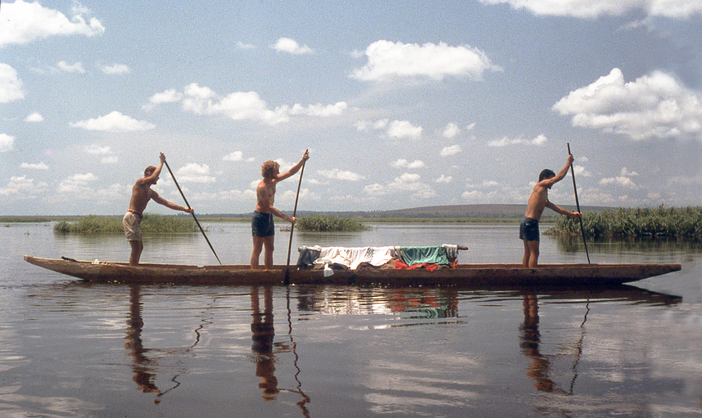
All of us, now in our 60s, preferred to use my lightweight solo canoes (30 lbs) that I call Wee Bonnies. Rob and I used the skin-on-frame versions, while Phil always has dibs on the one I strip-built using light blue insulation foam.
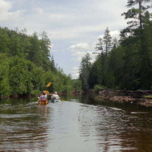
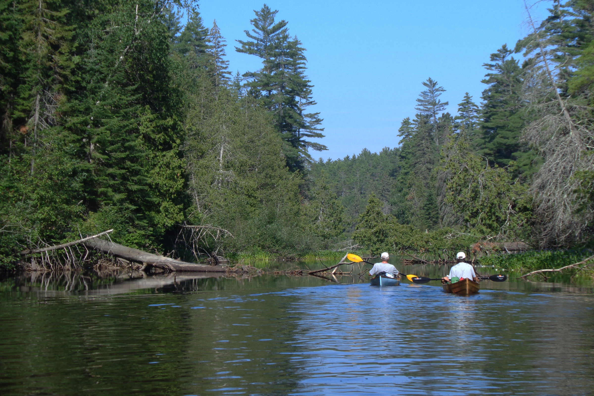
Launching into the shallow, gentle current of the Barron River, we slid slowly downstream in clear, cool water over black, white, and orange granite stones the size of golf balls.
As we headed downstream over a shallow stretch of the river, we had to be careful to watch for submerged log debris and rocks lurking just below the surface.
Phil took the lead, Rob followed, and I was at the end, making sure to avoid any sunken logs or boulders that were just under the surface of the shallow river here. The banks were high and thick with white and red pine, and as the land rose up around us, we paddled by sections of crumbled cliffs and boulders separated by stands of trees. Pickerelweed with its spikes of purple flowers was thick along both sides of the river, and log debris was everywhere.
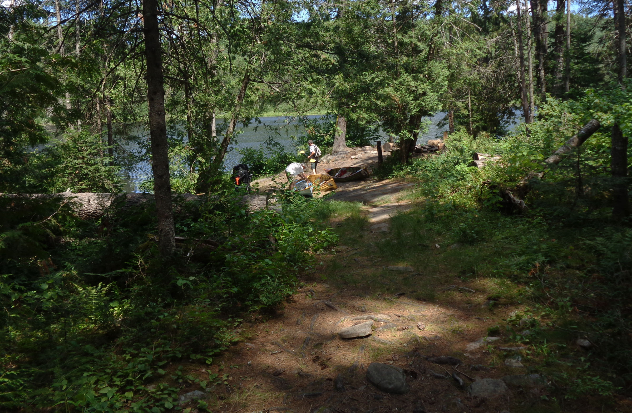
The river widened abruptly at the entrance to a small lake, and the rippled sand beneath us dimmed as the water gradually deepened. Brigham Lake is 200 yards across and twice as long and surrounded with pine and fir. We paddled to the south side of the lake and carefully picked our way through barely submerged shoreside rocks to a clearing in the woods.
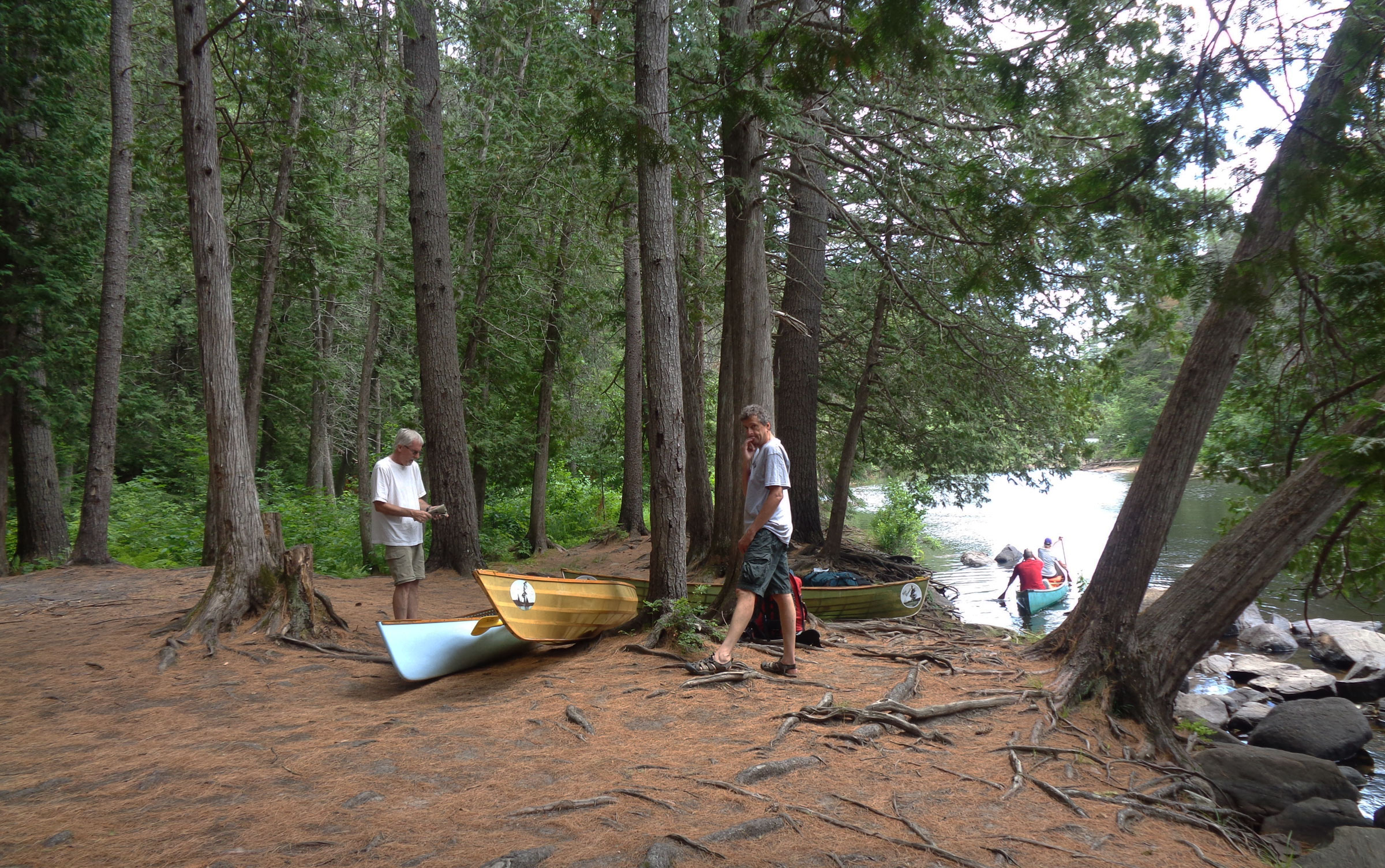
To prepare the canoes for portaging from Brigham Lake to Opalescence Lake we flipped the seats up so the yokes on the ends of the seats were ready for the carry. The trail was steep and rocky so we carried the canoes and packs in separate trips.
A campsite there had a stone-ring fire pit and log rounds for seats, but we were here not to stay but to portage to Opalescent Lake. The carry would be a challenge, as it rose about 150 feet over a distance of 800 yards. The path was well defined and easy to follow but strewn with ankle-twisting rocks and roots. It crossed steep-sided valleys and skirted steep rocky drop-offs, so we decided to carry our gear and canoes in two trips. If the portage was less rough, we would have chosen to do a single carry. We had plenty of time, so two trips it was.
The three of us picked up our packs and set off on the first crossing along the sun-dappled path, winding through the thick bush of pine. While I could see clearly ahead over 50’, I kept my focus downward, and stepped gingerly over rocks and roots, sometimes hidden by a thick layer of dried pine needles. We maneuvered down some rock steps, being careful not to lose our footing on the uneven ground and tumble down a rocky granite slope. We passed through a valley and crossed a small creek on a narrow bridge made of four long, springy 2x6s. In the lowlands around the creek, swarms of mosquitoes attacked us and we picked up our pace. As we got close to the end of the portage, we could see the sun sparkling on the water through the trees. It was a welcome sight because our packs, fully laden with gear and provisions for four days, were at their heaviest.
Roger Siebert
.
I set my pack down at the end of the portage, scratched my legs and arms, and then reached into the front pouch of my pack to pull out a bottle of bug spray. I hadn’t applied enough repellent to deter the little blood-sucking pests; I’d be better protected for the return trip.
Phil and Rob had already headed back and I could hear them in the distance, cursing the mosquitoes. Well slathered with spray, I hurried back over the rocky trail to catch up. Back at the Brigham Lake clearing, Rob flipped his canoe onto his shoulders and took the lead, with Phil close behind him. I brought up the rear again, hoping the mosquitoes would have had their fill from them and leave me be.
The third walk on the trail was easier because the canoes were lighter than our packed gear, and the mosquitoes left me alone, but the trickles of sweat running down my face seemed to attract deerflies. There was no cooling breeze making its way through the thick bush of pine, spruce, and fir, and the back of my T-shirt was drenched and sticking to my skin.
We set up our base at the Opalescence Lake camp site where we would stay for the next two days and do day trips. There was still some unpacking to do but but a refreshing swim came first.
I rejoined Phil and Rob at the end of the portage, and gently swung my canoe down on a patch of the hard-packed ground cushioned with pine needles. A soft cool breeze skimming across Opalescent Lake provided some relief on that hot day in July. The irregular chain of rocks that had dotted the portage carried on into the lake, making it difficult to find enough space to launch our canoes. The clear water, its dark-blue surface dotted with bright green lily pads, was breathtakingly beautiful and indeed opalescent.
The narrow lake, running ¾ mile from east to west, was hemmed in by red and white pine, cedar and spruce, and scattered maples and birch. We walked out onto a low rock ledge at the edge of the lake and set our canoes in the still water. After loading the packs aboard, we eased into our seats and pushed off.
Just around a bend from the launch, we glided up to a granite ledge on a blunt point of land where pale, shin-high grass surrounded bald outcroppings of bedrock. Working together, the three of us quickly carried the canoes up past the ledge and set them on a tracery of roots covering the nearly flat ground. In 2013 we had camped here in the sun-drenched clearing, a dozen yards wide. Since then a tree that had provided shade had been snapped in half, perhaps in a heavy wind storm a few years ago.
Rob pointed out to me that his canoe’s seat had started to split, as the synthetic cane weaving had finally succumbed to the sunlight after four years of use. I would do some patching later.
Since we’d been here before, I knew just where to hang my hammock and Phil and Rob knew where to pitch their tent. The bedrock, of course, made it impossible to set tent pegs, so we weighted them down with rocks. My hammock was strung between two large pines where the bank started to slope down to the lake, so I’d have a good view of both the lake and sky.
With our camp set up, we could take advantage of the clear lake water just a few yards away. We dove off the rock ledge, swam out about a quarter of the way across the lake, and bobbed around, enjoying the refreshing feel of cool water below the warm surface layer.
As we climbed out of the water, Phil noticed blueberry bushes at the edge of the clearing. The berries were so sweet, it was hard to save some for breakfast.
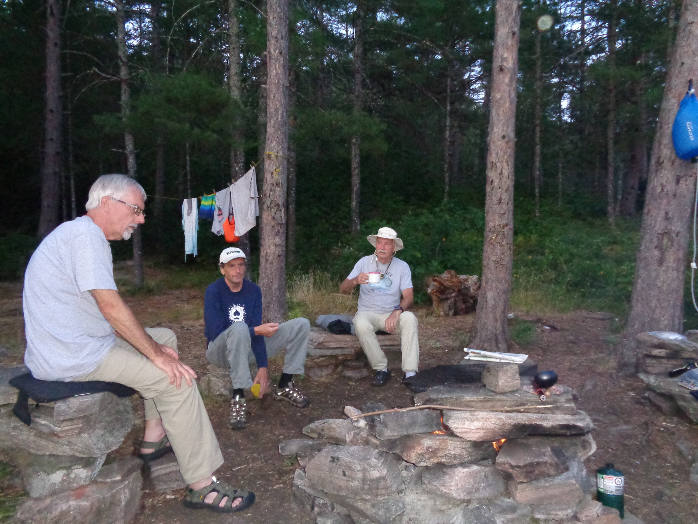
Rob, Phil, and I have a tradition of having steak for dinner on our first night at camp. We had brought a frozen, precooked meal of steak, potatoes, and veggies. It had thawed during the day and all we had to do was to warm it up on our camp stove. For dessert, I’d brought a bar of dark chocolate.
With supper over, dishes done, we needed to pack all the food in a bag and hang it in a secure location outside our camp beyond the reach of mice, chipmunks, raccoons, and bears. We found a tall dead tree about 100’ to the east and Phil and I took turns trying to throw the rope, with a small rock tied to one end, up over the branch about 20′ up. I missed, but Phil did it on his second try. We hoisted the bag and headed back to camp. We made a small fire in the campsite’s fire pit, a ring of flat granite rocks piled in several tiers. Flickering flames spread easily across the dry dead branches Rob had gathered. Watching the flames was calming, and, tuckered out, we soon headed for our sleeping bags. Stargazing would have to wait. We were in bed by 10 o’clock, but I couldn’t fall asleep. Bullfrogs seemed intent on singing all night, and one was just 10′ from my hammock. Every 40 seconds he let out about four or five deep “ribbits.” I fell asleep at about 2 a.m., only to be awakened by two loons three hours later. Their haunting calls echoed off the far shore, making it sound like there were more of them.
After a breakfast of oatmeal and coffee, I worked on the seat on Rob’s canoe. I always carry some 1/8″ nylon cord and it worked for reweaving the damaged half of the seat. With a foam cushion added, it would be almost as good as new, but feeling somewhat guilty that I hadn’t replaced that old cane in the spring, I let Rob use my green skin-on-frame canoe and I would take his.
A light morning breeze ruffled the lake just before we launched for our day trip to explore Cork Lake.
Our plan was to go for a day trip to Cork Lake, east of Opalescent Lake via a 750-yard portage. We paddled slowly down the far shore of Opalescent Lake, taking our time, paddling as close to shore as possible to peer into the woods and enjoy the scenery. We passed a campsite on a rocky point; some trees there had been toppled by a small tornado that had passed through in July 2013. Massive pines lay on their sides, root structures upright like a giant saucer on edge.
The portage to Cork Lake was as reasonable as a portage through the bush could be, and we were carrying only light daypacks with our canoes so we only had to walk it once. It didn’t take us long to reach the shore of the lake.
Cork Lake had only three campsites, and only one was occupied that morning. The water was crystal clear, but the decaying debris on the bottom made it look an inky black. We hugged the shore and saw a few loons. The shallows along the shore were cluttered with underwater logs and a lot of rock ledges, but the water was so clear they were easily seen and avoided. One ledge was a massive dome of bright, gold-colored granite that loomed just 6″ under the water.
We took our time, circled some boulders, and squeezed our canoes in behind others.
When we stopped for lunch on Cork Lake, I pulled into a shallow, very slippery rock cove and let the north wind hold my canoe in place while we ate.
Heading north along the eastern shore, we stopped about halfway for lunch at a flat, scrub-covered rock ledge protruding out from shore. Phil and Rob pulled their canoes out of the water to keep the northerly, now steady breeze from sweeping the canoes away. I circled around to a cove on the north side of the landing, where the wind would hold my canoe mostly afloat over a smooth shelf of rock. We sat in silence, taking in the warm sun and eating lunch. Rob and I dove into the cool, clear water, swam well out from shore, and just floated, taking relief from another hot and humid day.
Phil and Rob paddled close enough to touch the cliff that bordered the east shore of Cork Lake. The vertical rock face extended well under water.
We continued our loop of the lake and paddled up the east side to massive cliffs of multicolored granite that towered over it. Orange lichen made the cliffs look as if they were spray-painted.
We made the carry back to Opalescent Lake and just as I stepped into my canoe, I slipped and dropped right on the back rest, snapping it from the thwart. I couldn’t paddle with my back up against the thwart, so I used a water sandal as a cushion and paddled gently back to camp. I rummaged through my pack to see what odds and ends I could use for repairs. I had thrown in a couple of bicycle inner-tube strips as general-purpose bungee cords. It wasn’t a pretty repair, but it worked to hold the seat back on the thwart.
Back at the Opalescent Lake camp after a day of paddling, Phil, at left, gazed at the small fire in the fire pit. Rob, center, and I relaxed with a cool drink.
As the evening dimmed the perfectly clear sky, Venus appeared, followed by the brightest stars one by one. Soon the sky was filled with constellations and streaked by shooting stars traced by satellites. When we hit the hay, it was nearly midnight with so many bullfrogs croaking that it sounded like white noise. Loons again woke me up early.
The morning was hot and humid even as we were getting our daypacks ready; we launched and set out to explore Barron Canyon. Three shadow-dappled portages through the woods, a 350-yard paddle across tiny Brigham Lake, and we were back at the Barron River 650 yards downstream from where we’d first launched two days before and very close to the canyon’s west upstream end. We launched the canoes into the clear shallow water where the river was running fast over a bed of tumbled granite stones. We slowly traveled downstream—sometimes lightly paddling, sometimes just drifting—and as the embankments flanking the river rose over us, the water deepened and the current slowed. Hemmed in by rough boulders, the river flowed past the stands of white pine, then towering cliffs where trees had taken root in small crevices in the rock and grown tall with their backs up against the vertical sides of the canyon walls. The cliffs rose over 300’ high and were streaked chalky white and sooty black with minerals leached by rainwater, and the rest of the rock was stained cinnamon brown or draped with moss; only a few places showed the rock’s real color. We paddled beneath outcroppings of granite that were cantilevered over the river.
Phil got ready to step into his Wee Bonnie for the final leg into the Barron Canyon. The water was so clear it made the canoe look as if it were floating in air.
About a mile or two downriver—I’d lost track of how far we had come—we found what seemed to be the only accessible spot to pull up our canoes and have a bit of lunch. We climbed up into a secluded grove of widely spaced slender red pines, then sat and looked out at the slightly rippled narrow river and at the pine-covered steep rocky embankments. A few other canoeists paddled by.
Rob gazed up at one of the massive multi-colored granite cliffs that stretch up over 300’ high. Hikers could peer back down from a trail at the top.
It was time to start the long trip back, so we launched and headed slowly upstream the mile or so back to the portage we had come through a couple of hours ago. A great blue heron flew ahead of us, landed a short distance away, only to fly ahead again at our approach. A beaver swam across the river in front of us; the heron landed once again and finally just waited for us to get by.
As the water grew shallow approaching the portage, we got out of our canoes and walked over the pebbled bottom, with the cool water lightly flowing over our feet. We pulled the boats upstream 60′ or so. A couple of hikers were moseying along the river bed in the ankle-deep water as if they were strolling in the park.
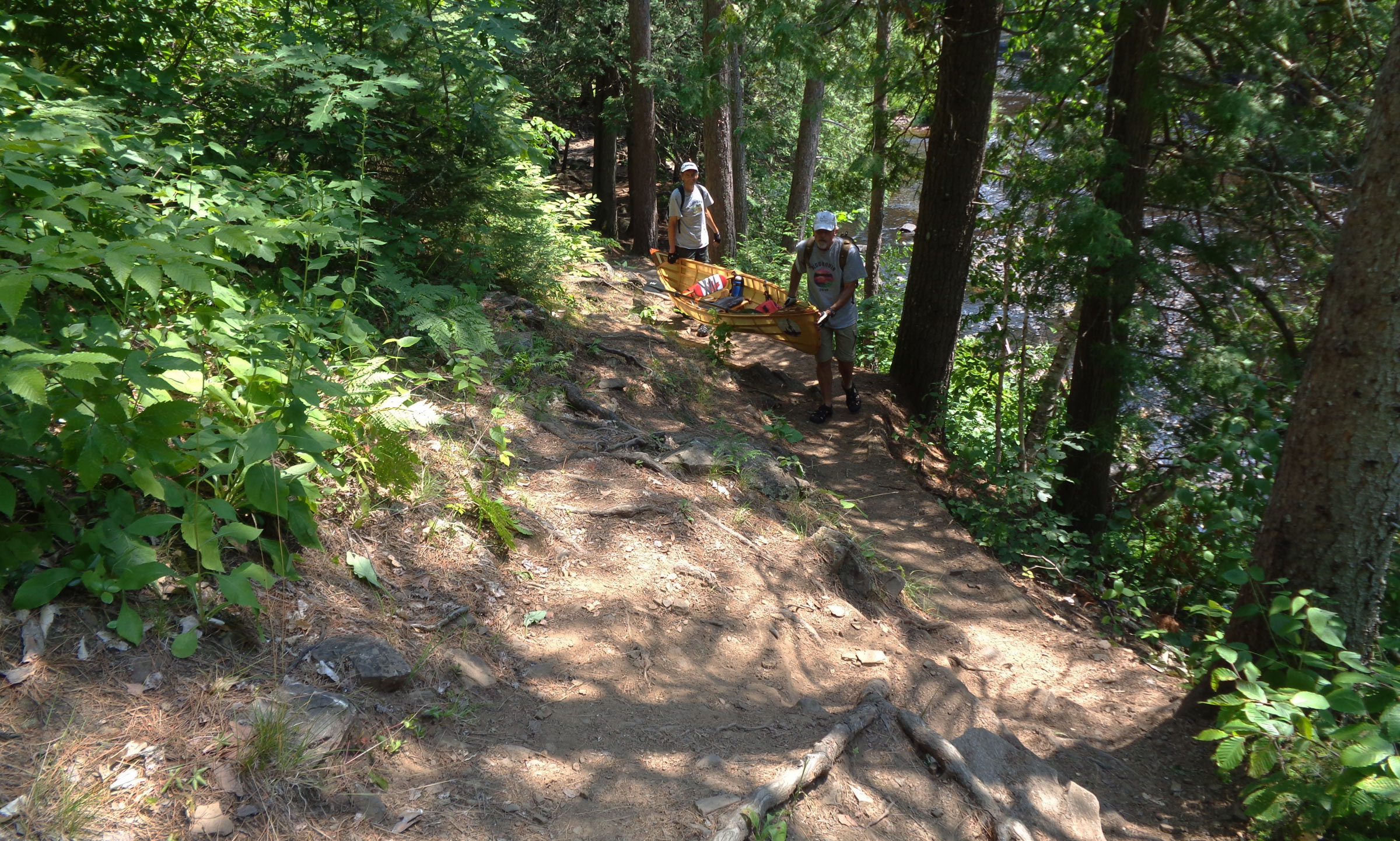
Phil and Rob shared the carry of one of the canoes as they hiked up the steep, rocky portage trail as we headed back toward Brigham Lake
The portage was short and would now be a little easier with our lightened packs, though rough with lots of roots and rocks to carefully step over. We carried up the initial steep slope of the portage one canoe at a time. Once at the top the path was now level but high up from the river bed. I chose to carry my own canoe with my lunch bag strapped to the thwart. Phil and Rob chose to carry both their canoes parallel to each other, holding their daypacks, with one person at the front and one at the back. We stepped along a steep and narrow path with the Barron River to our left and barely visible through the trees. Halfway along the portage, we took a short break at the narrow falls and rapids known as the Brigham Chute. The water there crashed down over a small waterfall and swirled around in side-streams to get through all the rocks.
Stopping for a break at the Brigham Chute, Rob decided to climb down and sit out in the center of the stream. Phil and I thought the climb down to be too precarious and remained up on the embankment.
From the Chute it was only a short walk to the river, where we launched, paddled a short distance, then made the100-yard portage back to Brigham Lake. Then the longer 800-yard portage uphill put us back into Opalescent Lake, and a paddle around the corner put us back in camp.
That night we were beat and all in bed before 9:30. The evening was hot and humid, and I had the fly of my hammock flipped back to catch whatever breeze there might be. I gazed up through the bug netting at the evening sky. I could clearly see the stars and even the glowing band of the Milky Way, and soon slipped into a deep sleep.
Heading back up stream on the Barron River, we approached our launching point from a few days prior. The solo canoes could easily maneuver in and around any debris we encountered.
We were up the final morning shortly after 6 a.m. We had our breakfast, took a quick swim, and then broke camp and retraced the route we had come three days earlier via a short paddle, again the 800-yard portage into Brigham Lake, and back into the Barron River, but this time heading northwest upstream 3/4 mile, with a final carry up the hill to the parking lot. It took us a couple of hours to get back to the cars and packed up for home.
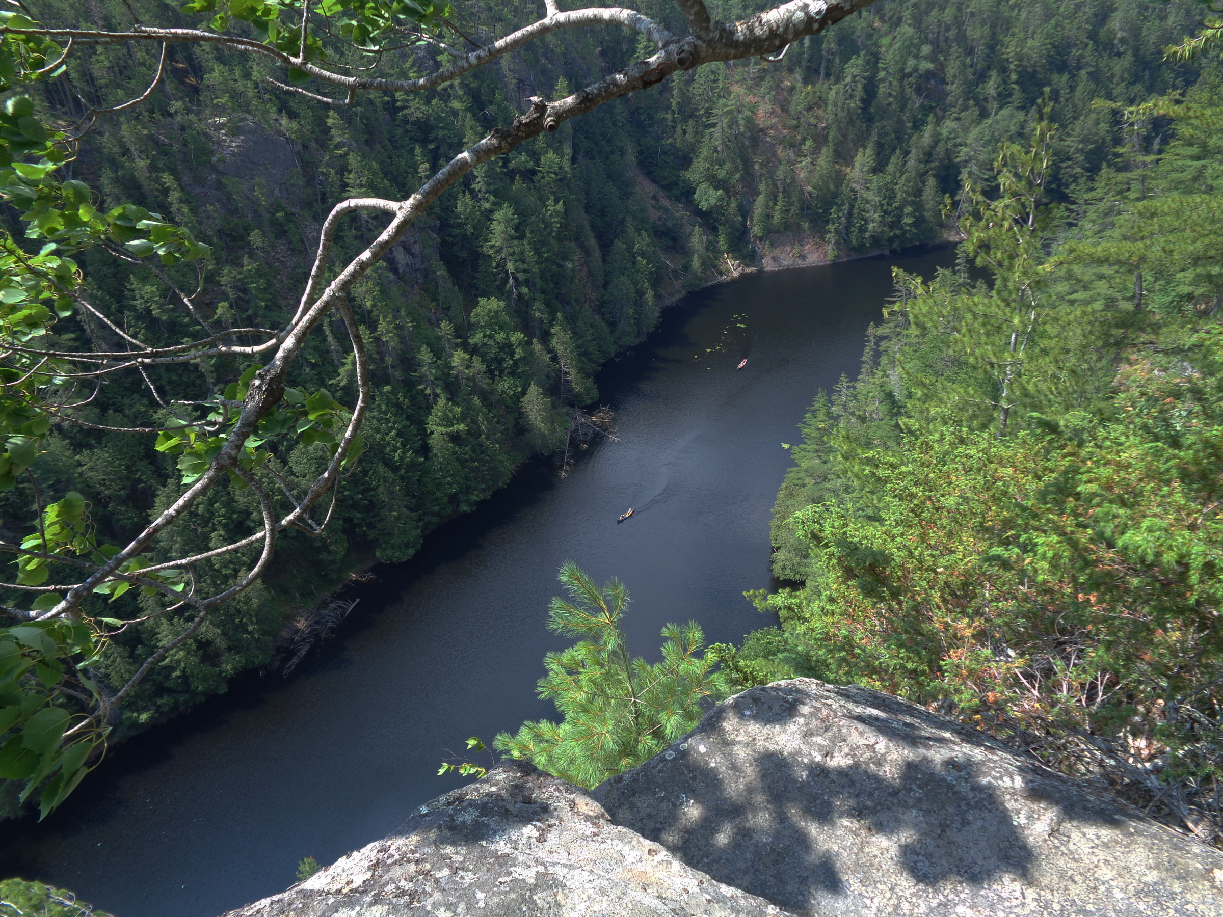
Gazing down from a dizzying height on top of the Barron Canyon trail we watched canoes coming down stream through the canyon.
It was still early in the day, so we drove the short distance to the Barron Canyon Trail, parked, and hiked up the steep, well-worn trail leading to the top of the canyon. I looked down over the edge at the meandering river. In the distance, three canoes, almost invisibly small, traveled downstream and vanished around a wooded bend.
Phil Boyer retired in 2017 after working 38 years in R&D in the telecommunications industry. He now keeps busy teaching karate at two local clubs and building boats. He has been around boats his whole life, starting with paddling as a kid. At age 11 he built a sailing pram with a bit of help from his father. In 2006 he began building solo canoes and now has four of them, featured in the August 2019 issue. Phil’s interest turned to building SOL CANADA, his solar-electric boat, in 2015. His next build will be a solar-electric version of the Power Cat he read about in the March 2016 issue of Small Boats Magazine.
If you have an interesting story to tell about your adventures with a small boat, please email us a brief outline and a few photos.
North Hero Island dipped out of sight as I looked up at two converging waves. Both were cresting, the southerly wind blowing spindrift over my head. My hands, already seized from a vice-like grip on the paddle to defy the wind, gripped even more tightly as I nosed the bow of my canoe into the slot between the waves. I began to wonder how long I could muster the strength to continue into this wind.
I had started several hours earlier in Swanton, Vermont. My wife, Viveka, had informed me that the weather was forecast to be the roughest so far: heavy rain and very strong southerly wind, the worst possible for paddling south on Lake Champlain. Her advice was to sit out the storm in the motel, but sitting still is not my style. Nor is getting behind schedule.
Peter Macfarlane
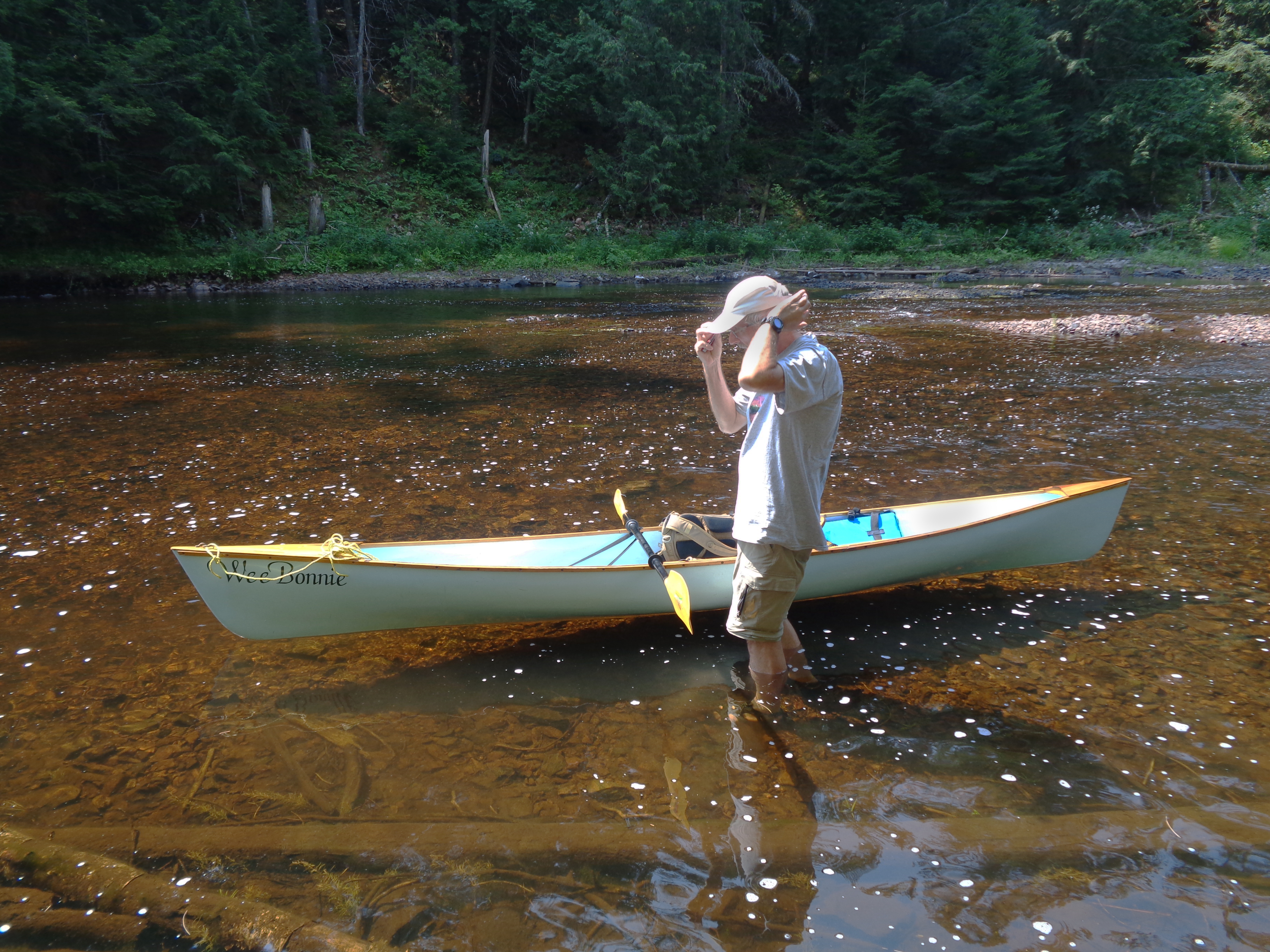
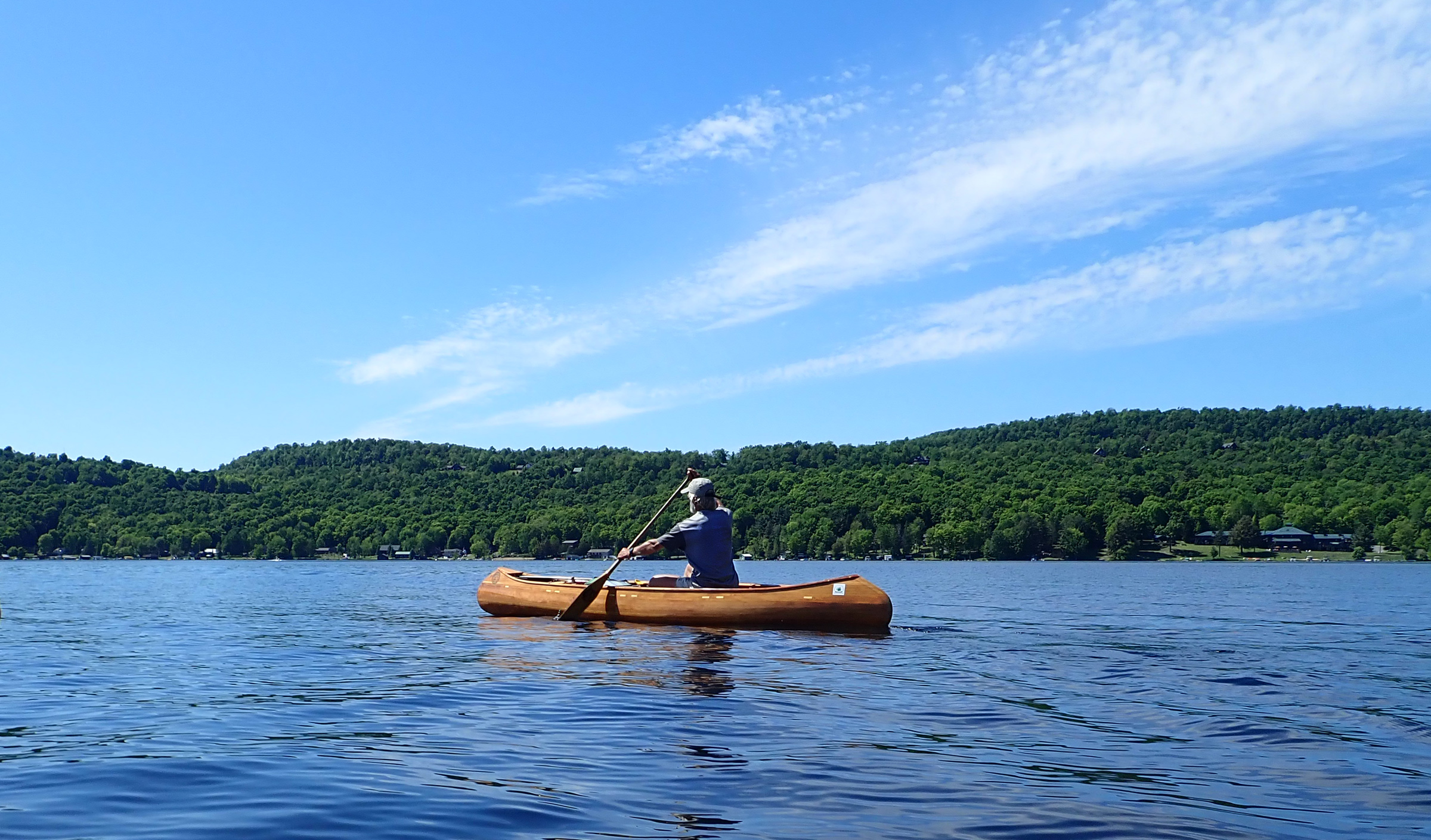
My canoe is one I designed for fast solo travel and built light for easy portaging. For the Northern Forest Canoe Trail, I added some extra fiberglass on the bottom to better survive the inevitable collisions with rocks. Even with the reinforcements, the canoe weighs just 37 lbs.
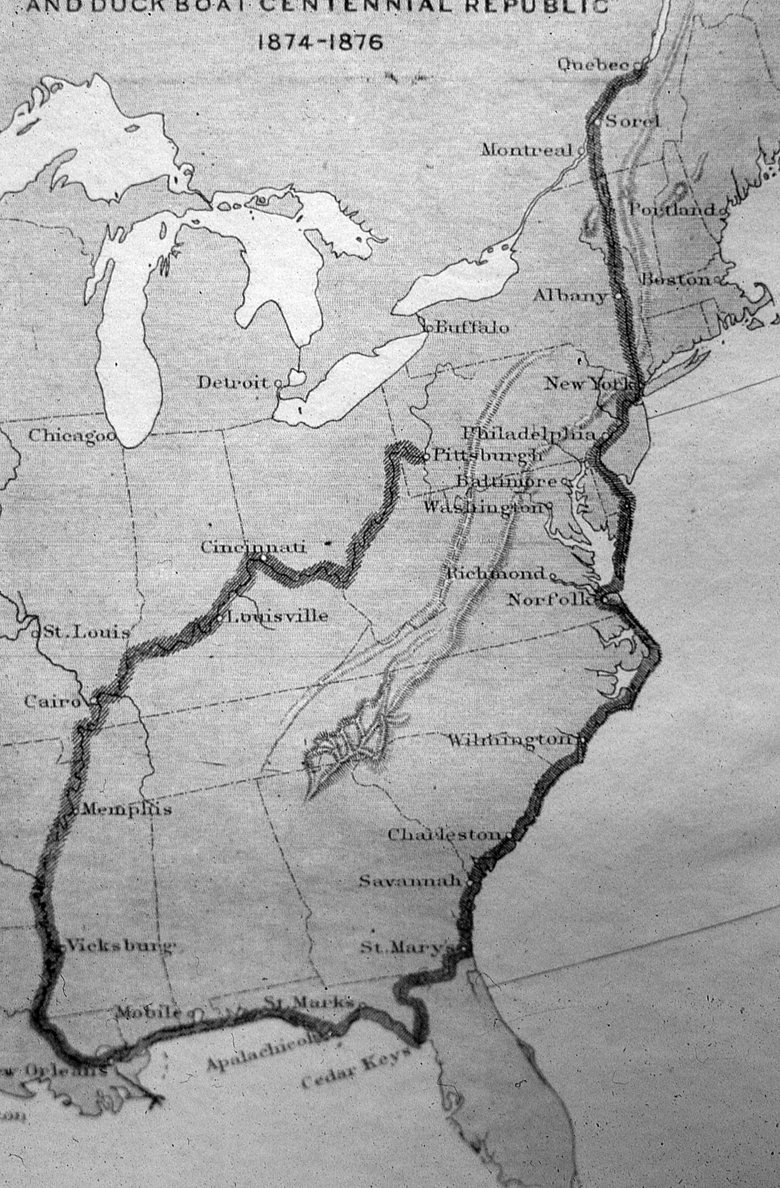
This was three weeks into my 2018 through-paddle of the Northern Forest Canoe Trail (NFCT). I had first paddled the trail five years previously, a solo trek of over 750 miles in 28 days, in a 14′ cedar-strip canoe that I designed and built. I was now paddling from east to west, from Fort Kent, Maine, to Old Forge, New York. If successful, this would be the first recorded backwards through-paddle. Of the trail’s 13 major rivers, the conventional direction–west to east–involves paddling nine downstream and four upstream. Nobody in their right mind would go “uphill” from east to west. Part of my motivation was to be the first. The challenge would involve many miles of paddling against the current, rapids, and prevailing headwinds.
On the eve of traveling to the launch at Fort Kent I spent the night in Shelburne, New Hampshire, with friends Ray and Hildy. When I woke and opened my eyes, the first thing I saw was the spine of one of the books on the shelf next to the bed: The Darwin Awards.
The long drive to Fort Kent that day, May 13, was not without trepidation. Just two weeks earlier, the St. John and Allagash rivers, the initial upstream run of over 90 miles, had been in spate with meltwater, and the Allagash had burst its banks. I had watched online as flow rates fell frustratingly slowly, while webcams showed an unusually slow retreat of ice on the lakes. When we reached the levee in Fort Kent, we climbed to the top for the moment of truth. Would we see the St. John at a navigable level? Or would we turn around and take the long road home? Although the river was still above the seasonal norm, it was no longer a raging torrent. The next morning, I launched under a cloudless blue sky, bade farewell to my support crew, and paddled west, ascending the St. John River.
Ray and Hildy Danforth
Leaving Fort Kent to begin my ascent of the St. John River, I was immediately focused on the first challenge: crossing the outflow of the Fish River, less than 100 yards upstream from the launch ramp. The black spike-like steeple rising above the far bank marks a church in the town of Clair, New Brunswick. For 16 miles upstream, the river separates the US from Canada.
The start, up the St. John and the Allagash to Churchill Dam, was against the flow, including several rapids. Where depth allowed, I used my long-bladed ash paddle. In shallower water, I turned to a shorter paddle with a wider blade. And where rapids started, I turned to my poles, a pair of ski poles. Kneeling to double-pole, I pushed off the rocky riverbed and propelled the canoe forward this way for several miles. On the first day, I ascended nearly 24 miles of the St. John. and on the next day I pushed upstream on the Allagash and made the first carry of the trip at Allagash Falls. The NFCT includes over 50 miles of portages around obstacles and over watershed divides. I continued on the Allagash Wilderness Waterway. At the end of the third day, I stopped not far from the foot of the Chase Rapids, the largest and most powerful on the Allagash. I had worked hard, putting in 12-hour days to reach here, in order to tackle the nearly 5 miles of rapids while I was fresh in the morning.
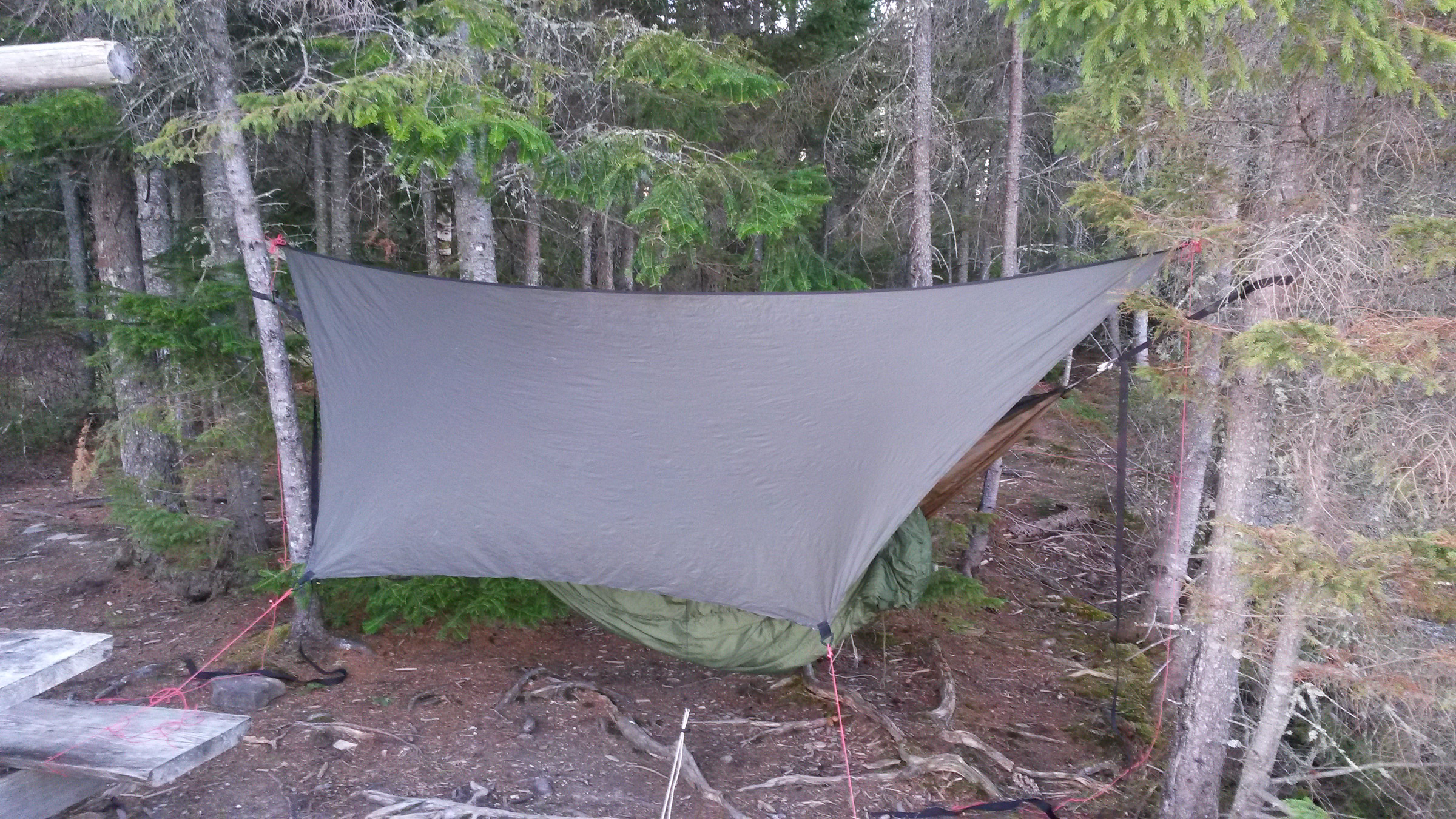
There had already been several hard frosts, and overnight the cold had turned my drinking water to ice and frozen my toothpaste and neoprene-lined boots. I had to boil extra water to thaw the boots; together with a pair of dry-pants, they were excellent for wading where the current was too strong for poling. I had slept well in spite of the cold. The hammock under-quilt I’d made from an old sleeping bag was highly effective.
Peter Macfarlane
By camping with a hammock I avoided the need to find even ground, and its absence of rigid parts made it easy to pack. My camp here on the bank of the West Branch of the Penobscot River, near the mouth of Pine Stream, was quite remote but furnished with a picnic table.
I was now down to one ski pole. I had lost the other while wading up the rapids downstream from Round Pond. It must have been flicked out by springy vegetation on the bank, and I could not face returning downstream on a likely wild goose chase. While my solitary pole was useless for propulsion, it kept me upright when wading on algae-coated rocks.
I launched into Chase Rapids and the initial eddy-hopping was a thing of great beauty, accelerating up one eddy behind a rock and crossing the flow to another eddy. Where the current was too powerful I waded, and where there were falls I heaved the loaded canoe up over them. I had been making astounding progress but about 1/2 mile from the top end of the rapids, I slipped on slimy rocks yet again and decided to take the portage trail rather than risk injuring myself.
I arrived at Churchill Dam at the top of the rapids ahead of schedule, having ascended two major rivers in under four days. As I then gained a few miles, the Allagash headwater lakes, rimmed with green conifers, glistened under bright sun.
Roger Siebert
.
The Mud Pond Carry, the next day’s challenge, is an historic portage between Umbazooksus Lake and Mud Pond, something of a rite of passage. Five years ago, I had avoided this 1.7-mile trudge through deep mud by taking an alternative route, and now was my chance to earn my stripes. I paddled on a compass bearing across Mud Pond to find a small inlet where I expected to find the portage. I’d been singling the carries, taking everything at once, so I loaded the pack on my back, lifted the canoe overhead, and set out on a floating bog that sank beneath my feet at each step. Soon I was on dry ground, thankful for the lack of spring rain, but the easy going didn’t last long. I arrived at a very deep bog and had to detour around it. The path I found soon became overgrown with young trees. I pushed the canoe into spaces that resisted my efforts to squeeze the canoe through, so I backed out. After a few such shunts, it was clear that I was not on the trail, and retracing my steps soon became impossible; pressing forward on a compass bearing was my best hope.
Finally, the saplings closed in so tight that the canoe would not fit through them. I was stuck and lost deep in the Maine woods. To make matters worse, my water bottle was nearly empty and it was the hottest part of the day. A wave of panic surged through me. I knew there were roads to the west and south, so I could rescue myself, but I’d have to abandon the canoe. That option was almost unthinkable and so I had nothing to lose by forging ahead.
I used brute force to ram the canoe mercilessly between saplings, splaying them apart. I kept at it, making a few feet with every effort, and suddenly emerged into a region of felled trees. In sheer relief I danced from trunk to trunk, before stopping to take stock of my situation. I discovered that my camera, which I’d strapped to my pack belt, had been torn away somewhere in the brush. Lost with it was the record of the trip up to that point. After filtering a little water from a post hole, I searched for the camera, but only briefly: losing track of the canoe and pack would have made a bad situation worse. I dejectedly resumed the trek, following the line of felled trees to a road, which led to the foot of Umbazooksus Lake.
I had singled the Mud Pond Carry, but at a great cost and not by the traditional route. The rite of passage I had hoped for had remained unfulfilled. I paddled with sadness down Umbazooksus Stream, the first short downstream for which I had worked so hard. Partway down this stream, I remembered that my phone could take photos, and if the sun kept shining, my solar charger would recharge it.
Peter Macfarlane
Launching through the breaking waves at the North East Carry into Moosehead Lake was the first challenge here; paddling against the wind was the next.
Headwinds had plagued me since the start at Fort Kent and, as I was ascending the West Branch of the Penobscot River, a strong southerly sprang up. After traversing the North East Carry, a 2-mile portage from the Penobscot, I arrived at the northern end of Moosehead Lake. At 33 miles long, it is the largest lake in Maine. The southerly wind was now blowing at 20 to 25 mph. I abandoned plans to aim for the exposed Seboomook Point, 3 miles to the west, in favor of a more sheltered campsite farther south on the eastern shore. Either site would require launching into substantial surf.
I enjoy the glide of the canoe and the rhythm of paddling, but there was none of that in this headwind. Every stroke required great effort and accelerated the canoe from a standstill. I inched south along the eastern shoreline just outside of the breaking waves. Blocks of broken ice at the water’s edge reminded me that ice-out here had only recently occurred.
At the end of another 12-hour day I pulled into a campsite in Big Duck Cove, exhausted, having covered 29 miles upstream and into the wind. It had been hard work to keep from going nowhere or even getting pushed backward.
Strong headwinds continued to haunt me. The next day, I headed west from Moosehead Lake up 3 miles of the Moose River to Brassua Dam. Emerging on Brassua Lake a strong northwesterly made paddling a struggle, and I ended the day on Long Pond beating into a 25-mph westerly.
Later a strong southerly would slow me on Fish Pond and Spencer Lake, and I would travel much of the 18 miles of Flagstaff Lake into another headwind just as strong.
When I reached Jackman, Maine, I took a half day of rest in the motel where I had mailed a food package, the first resupply of three. I took a shower, my first since launching eight days before—the frigid lake water temperature did not invite taking a dip to rinse the sweat and grime away. The skin on my hands had developed painful splits, especially on the exposed fingertips, despite wearing fingerless gloves for protection; furthermore, the extreme effort of paddling so many miles upstream and upwind was affecting my shoulders. At night, shooting pains radiated along my arms. And having to grip the paddle extremely hard for long days, merely to keep hold of it in the strong wind, my fingers were now seizing up overnight and required much coaxing to flex again. I needed a rest.
Peter Macfarlane
Most of the South Branch of the Dead River had too little water for paddling. The upper reaches had just enough water, but were obstructed by fallen trees.
From Jackman, my route took me farther up the Moose River before a carry to Little Spencer Stream, which, with its impoundments of the mile-long Fish Pond and the adjoining 4-1/2-mile-long Spencer Lake, led me down to Spencer Stream and the Dead River. More upstream work on the Dead River brought me to Flagstaff Lake, above which the South Branch of the Dead River is often bypassed due to low water. I ascended the first 3 miles of it, but there was not enough water to sink a paddle. The river was so low that I faced wading almost the entire length on slippery rocks; carrying along the Stratton–Rangeley road that paralleled the river was the better option.
I escaped to the road at the first bridge, and that day carried a total of over 17 miles, putting into the river only for the final 3 miles above Fansanger Falls. The last 4 miles of carry over the watershed divide to the town of Rangeley were to reward myself with a night in a B&B.
The struggle against headwinds continued as I traversed Rangeley, Mooselookmeguntic, and Richardson lakes. On Mooselookmeguntic, the wind made my ears vibrate with the ripping noise of a flag in strong wind.
Ray and Hildy Danforth
Tackling the Pontook Rapids on the Androscoggin River saved carrying for 1-1/2 miles along the riverside road, but colliding with a rock resulted in a minor split in the hull of the canoe. I sealed the crack with tape, a repair that lasted for the rest of the journey.
On my 13th day, I paddled into Umbagog Lake, which spans 10 miles of the New Hampshire border. I had almost reached the NFCT’s halfway point. Umbagog drains to the west into the Androscoggin River, my first major downstream run. It was raining, but the river was everything that I wished for: plenty of flow and wonderful rapids with clear channels. The quick run lasted less than a day, but I relished the power of deep, fast water pressing against my paddle. My hard work had earned this. Below Pontook Dam, Ray and Hildy collected me for pizza and ice cream—a welcome change from dried food—a spare pole to replace the one I’d lost, and a comfortable night at their home. I slept again with The Darwin Awards smirking by the bed.
Peter Macfarlane
The upper Nulhegan River offered some fine paddling through a flood plain, as well as some upstream navigation challenges where streams converge. Tight meanders ensured that this section took longer to paddle than a quick look at the map might suggest.
Ray drove me back to the Androscoggin where I had left off so that I could carry 4 miles to the Upper Ammonoosuc River where another day of downstream across northern New Hampshire brought me westward to the Connecticut River between New Hampshire and Vermont and the Nulhegan River in Vermont. For me, they were two more upstream runs, and a tough section of the Nulhegan has some challenging, rocky rapids. Rather than carry around them, I chose to tackle these rapids upstream, balancing on slippery rocks while hauling the laden canoe up the falls, all while trying to remain calm amid an onslaught of blackflies. As the river opened out into flat meander, I looked back on the very short but tough ascent with immense satisfaction.
From Island Pond, the high point of the trail in Vermont, I paddled downstream on the Clyde River, pushing between alders, negotiating deadfalls, crossing ponds, tackling shallow, rocky rapids, and carrying around dams, all under bright sun with a tailwind. The Clyde deposited me at Newport, a town on Lake Memphremagog, just 5 miles from the Canadian border. The wind remained at my back on the lake straddling the international border, and I checked in with Canadian Customs by phone. A half dozen miles farther north, I hauled out for the Grand Portage, another half dozen miles, this time by road west to the Missisquoi Valley. Here I declined a ride offered by the person who lived nearest the far end of the carry. I doubt he understands even now my desire to be self-propelled.
Peter Macfarlane
When I ascended the Missisquoi River five years previously, the water had been lapping at the tops of the banks. During my long descent on this journey, I scraped over many shoals.
On my two-and-a-half-plus-day descent of the meandering Missisquoi across Québec and northern Vermont I was paddling at low water between tall, steep banks, looking up at trees that I had fought through on my west-to-east journey when the same river was in flood and about 7’ higher. Farther down the Missisquoi I re-entered the U.S. and met Viveka at Enosburg Falls for a full day of rest.
At the end of the third week I was back on the Missisquoi, finishing this long downstream run. When I arrived at Swanton, 7 miles from the mouth of the river, I was ready to take on Lake Champlain, despite the weather forecast and advice to sit tight. I set out on the crossing, a mile-plus passage from mainland Vermont to North Hero Island, in a white-streaked sea of tumultuous waves. A southerly gale blowing almost 30 mph and gusting higher was tearing up both sides of North Hero, and drove waves that converged around the north end of the island to rise even higher.
The cresting waves slapped water into my canoe from both sides. It swirled around my knees as the little canoe pitched and rolled yet remained reassuringly stable; the challenge was to make progress into a 30-mph wind. I dropped my head and put maximum effort in every stroke, ferry-gliding alternately to east and west to vary the muscles in use. In this sawtooth fashion, I finally pulled exhausted into the lee of North Hero and uncurled my body, having made the hardest crossing I ever wish to make.
To have stayed there would have put me behind schedule, so, after some recovery, I continued south on the more sheltered west side of North Hero. The only overnight options were on the east, so at the Carrying Place, a mid-island neck of land only wide enough to support a two-lane road, I pushed through a 90′-long steel culvert and emerged into the full blast of the wind. Camping on Knight Island, a state park 1-1/2 miles to the southeast across open water, was now unthinkable, so I set my sights on North Hero Village, a mile alongshore to the south.
The headwind now brought me to a complete standstill. Paddling as hard as I could, I achieved nothing. Defeated, my only hope was to carry along the road. For the first 1/2 mile, a line of trees sheltered me from the wind, but beyond it the carry turned into a nightmare. I leaned the canoe strongly into the crosswind and frequently had to plant a leg wide just to remain standing. After an exhausting carry I finally arrived at an inn, booked a room, and collapsed on the bed.
The next day, feeling utterly beaten I completed the crossing of Lake Champlain in mercifully calmer conditions, coming ashore at Plattsburgh, New York. I received a text from Viveka about a body being found in this area of the lake. I replied, reassuring her by saying, “Still kicking!”
From downtown Plattsburgh I began the ascent of the Saranac River. It was flowing well but shallow and with almost continuous riffles. Paddling, wading, and poling, I completed a stretch of upstream work that I was proud of, but on my 24th day, I still had to carry around a section of tough rapids, part of another day with 17 miles of portage. This brought me to Union Falls Dam, just beyond the upper reach of the whitewater.
Peter Macfarlane
The eastern shore of Long Lake in the Adirondacks provided a campsite with a lean-to at the perfect time of day. Amid the hard work of the trip, this was a jewel of serenity.
After camping above Saranac Lake Village, I reached Lower Saranac Lake, where I experienced the most perfect paddling imaginable. With the rising sun at my back and smooth, glassy water ahead, I paddled with a sense of connection from the pressure of water on the blade through me to the flowing movement of the canoe. The experience was all the more exquisite for its rarity on this trip.
After a 2-mile transit of Middle Saranac Lake and another 2 miles across the south end of Upper Saranac Lake, I portaged to the ponds at the head of Stony Creek. Descending a looping 1-1/2 miles brought me to the Raquette River for a 12-mile upstream leg to Long Lake, an aptly named broadening of the river 14 miles long and less than a mile wide at its widest point. I ended the day cooking dinner on a sandy beach while the sun sank over the Adirondack Mountains to the west.
From the south end of Long Lake, I finished the ascent of the Raquette River to Forked Lake and Raquette Lake, where I spent the night on Big Island, a few miles ahead of schedule and poised to bring this trek to a close the following day.
Peter Macfarlane
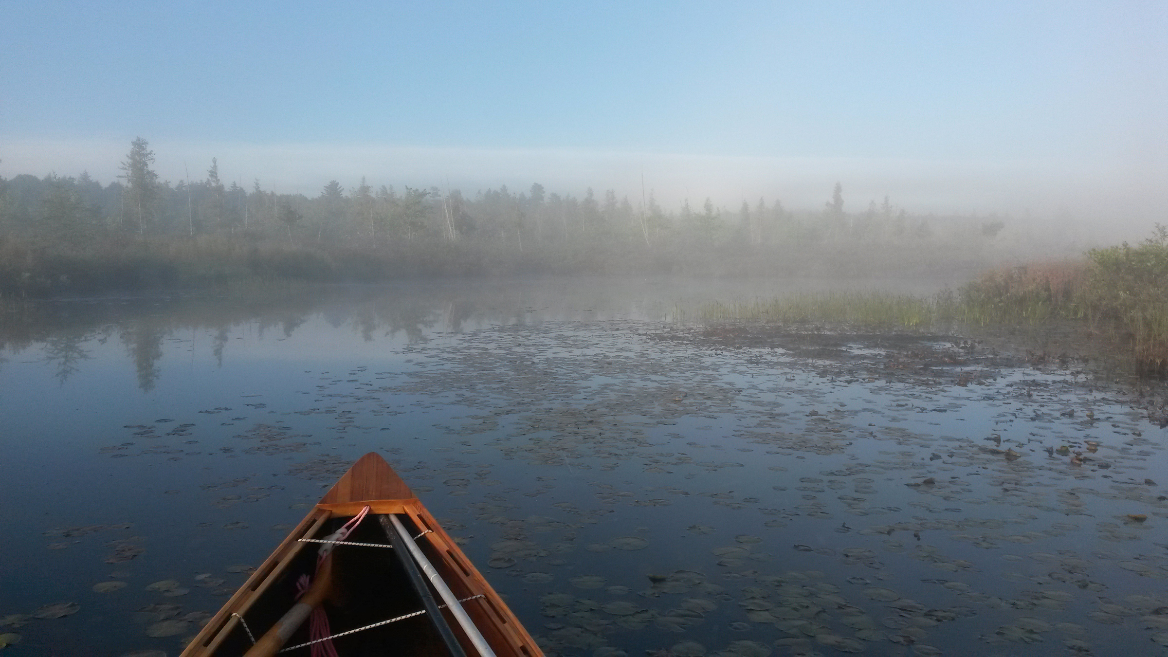
The final morning of any long journey is a special and bittersweet moment. The mist covering Brown’s Tract Inlet leading from Raquette Lake added an atmospheric touch to this one.
The 28th day dawned misty. I paddled up an ethereal Browns Tract Inlet, a final short, sluggish upstream paddle delayed by beaver dams across the flow. After carrying to Eighth Lake, the uppermost of the Fulton Chain, I was on the home stretch, a countdown of lakes from Eighth to First Lake, under bright sun and blue sky.
Peter Macfarlane
For the last few miles on the Fulton Chain to Old Forge, Viveka, Ray, and Hildy, escorted me, paddling one of my canoes.
My support crew—Ray, Hildy, and Viveka—paddled out to meet me on Fourth Lake, served me a sumptuous lunch, and then escorted me to the finish at Old Forge. On the final approach, while my friends paddled to shore, I held back and reflected.
With the end drawing near, my canoe’s wake stretches over 700 miles astern.
It had been one thing to set up this challenge; quite another to see it through to successful completion. The hard work of this trip was beyond what I’d anticipated. I expected upstream to be tough, even relished the challenge, but the headwinds had taken the difficulty to another level. Through all the trials though, my trusted little canoe had once more been my faithful companion.
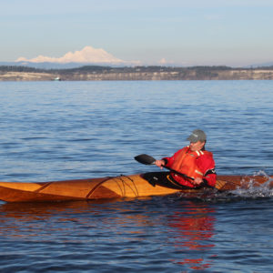
Following a career of teaching high school science in the U.K., Peter Macfarlane immigrated to Vermont to take up life as a musician. Playing and teaching the fiddle professionally has afforded him the time to indulge his passion for cedar-strip canoes, not only paddling them but also designing and building them as Otter Creek Smallcraft. The canoe pictured here is a Sylva, a solo touring canoe he designed, built, and paddled the full length of the Northern Forest Canoe Trail in 2013 and 2018.
If you have an interesting story to tell about your adventures with a small boat, please email us a brief outline and a few photos.
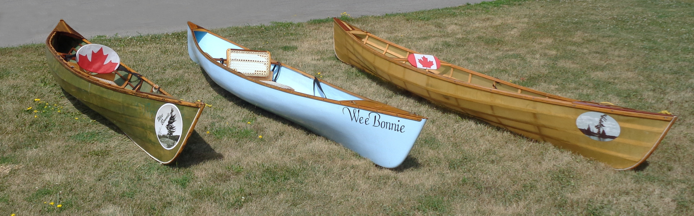
The Wee Lassie canoe dates back to the early 1880s when canoeist and outdoor writer George Washington Sears, known as Nessmuk, asked John Henry Rushton, a boatbuilder in Canton, New York, to design and build a small lightweight canoe. The result was the WEE LASSIE, an open cedar lapstrake canoe 10′6″ long and 27″ wide. While Sears, a diminutive man at 5′3″ and 103 lbs, also asked Rushton to build an even smaller canoe, SAIRY GAMP, most of us would need something larger. Mac MacCarthy, a century after Rushton, stretched the Wee Lassie to 13′ 6″ by 29″ and called the new design Wee Lassie II.
Photographs by Phil Boyer
Phil completed this skin-on-frame WEE BONNIE, the first of his canoes, in 2006. The maple leaf, emblem of his Canadian homeland, appears on Phil’s boats, often more than once.
Phil Boyer of Napanee, Ontario, started work on a cedar-strip Wee Lassie II in 2005 but only got as far as setting up the molds when he discovered that canoes could be built quite quickly as skin-on-frame boats. He decided to switch techniques while using the same molds. Western red cedar, salvaged from a deck he had demolished, supplied much of the wood he needed. He skinned the frame with ballistic nylon, dyed it green, and waterproofed it with two-part urethane.
In the spring of 2006, Phil’s sister died of cancer, and when he launched the canoe, he christened it in her honor. Her given name was Carol, but Phil had always called her Bonnie. She was born while her father was overseas during World War II and away during the first 1-1/2 years of her life. A Scottish nurse helped with the childrearing during his absence, and whenever she brought the infant Carol to her mother, she’d say, “Here is your wee bonnie.” The name Bonnie stuck and WEE BONNIE is what Phil called all of the modified Wee Lassie II canoes that he built.
This cedar-strip WEE BONNIE, launched in 2007, is the first canoe that Phil started on but the second that he finished. It had to wait while he used its molds for his skin-on-frame adaptation.
In the year following the launch of the first canoe, Phil went back to his original strip-built project. He was pleased with the canoe when he got it afloat, though at 42 lbs, it was heavier than the nylon-skinned version, and he thought he could do better.
Phil’s insulating-foam version of the canoe, built in 2009, weighed 32 lbs. The hull was finished “bright,” letting the light blue color of the foam come through.
In 2009, he decided to build another stripper and make it as light as possible. He substituted 1/2″ slices of foam insulation for the wood strips. The foam was much more delicate than wood and required care to get them to take fair curves between the molds. Even when glued edge to edge, the strips were very flexible and took a light touch to fair. Carbon-Kevlar fabric would have kept the canoe’s finished weight quite low, but Phil spared himself the extra expense and covered the hull inside and out with 6-oz fiberglass and epoxy. This third WEE BONNIE came in at 32 lbs, and Phil was pleased with how well the experimental construction performed.
The 2015 WEE BONNIE, the second of the three skin-on-frame canoes, was skinned with ballistic nylon.
In 2015 Phil built another skin-on-frame canoe, using lighter nylon to save some weight and equipping it with an innovative seat. A few years earlier, while canoe camping with two of his friends on Opalescence Lake in Algonquin Park, his friend Phil was using one of the three WEE BONNIEs and had commented that the portage yoke was a nuisance when not in use and suggested incorporating a yoke in the seat. Phil liked the idea and came up with a seat that pivoted to become a yoke. The new canoe got the latest version of the arrangement; switching it from paddling mode to portage takes just 30 seconds.
Even before the last of his four WEE BONNIE canoes was finished, Phil was thinking about the next boat he’d build, a strip-built solar-powered launch. We’ll hear more from him in the future.
Do you have a boat with an interesting story? Please email us. We’d like to hear about it and share it with other Small Boats Magazine readers.
We pointed offshore into a wall of fog, following a compass bearing until a steep hump of granite appeared, rising from the foggy sea, topped with spindly spruc—a sumi-e haiku illustration rendered with a few deft strokes. After pulling our kayaks onto the sand between the smallest islands, we carried our food bags up onto a slab of granite and made our lunch. The low-lying fog was dense enough that we couldn’t see beyond the ledges just offshore, but we could feel the warmth of the sun on our skin. As we ate, the chug of a motor slowly approached and a man’s voice, tinny in the still air, floated in the fog, describing the remains of a prehistoric village now submerged somewhere beneath the boat. He sounded vaguely familiar.
“Sounds like Garrett,” Rebecca said, and I recognized the Maine accent, the cheerful, curious inflection of the mail-boat captain with whom we’d often played Pickleball over the last winter.
I said, “Guess we’re all missing Pickleball today.”
“Summer.” Rebecca spread hummus on a cracker. “No one has time.” Normally we wouldn’t have had time either. We’d owned an art gallery in downtown Stonington for a dozen years, and during idle moments I’d stand by the window, gazing out at the archipelago, imagining a trip such as this: roaming the Maine coast in our sea kayaks, camping on the islands.
The boat passed unseen, Garrett’s voice overwhelmed by the motor, then that fading until we could no longer hear it either. Rebecca lay back against the granite. “I’d be happy to stay here tonight.”
“We could,” I said, but it was the second day of our trip and we’d only paddled a couple of hours and I still felt restless, wanting to put at least a few more miles behind us.
The fog finally dissolved, and the islands ahead were revealed like stepping stones. We launched before the haze could return.
We spent a couple of nights camped off of Stonington and on the Fourth of July, a summer day with fair-weather cumuli mirrored on the glassy swells, crossed East Penobscot Bay. Deer Isle lay behind us as we paddled four miles of open water toward the islands near North Haven. Our kayaks, laden with gear, sat low in the water and were slow to turn, but once in motion their momentum made the miles go by quickly.
We landed on Calderwood Island and pitched the tent, and after dinner, we sat on a ledge as the sky grew dark, gazing over the bay we’d just crossed. Stonington was a dark shape on the horizon until a lone firework lit the sky, followed half a minute later by the faint report.
Another firework exploded, a brilliant magenta chrysanthemum, and then another. We sipped our tea, watching until the finale, a half-minute of bright, silent chaos, was reflected in streaks across the bay followed by a thunder that echoed long after the last explosion faded. I lay back and felt the warmth of the granite ledge beneath me. The stars shone, crisp and clear.
Roger Siebert
.
Rebecca and I wanted to paddle along as much of the Maine coast as we could. With no home or job to return to, we had all the time we wanted, and were limited only by the seasons and our bank balance. We’d decided our trip would be more about spending time in places we liked than covering miles.
Photographs by Michael and Rebecca Daugherty
Just off Vinalhaven, Ram Island is a tiny islet surrounded by granite ledges. It was one of the islands we visited twice, both as we headed west and later on our way back east. I busied myself with chips and hummus and dinner (most likely a curry) while Rebecca painted the trees behind me.
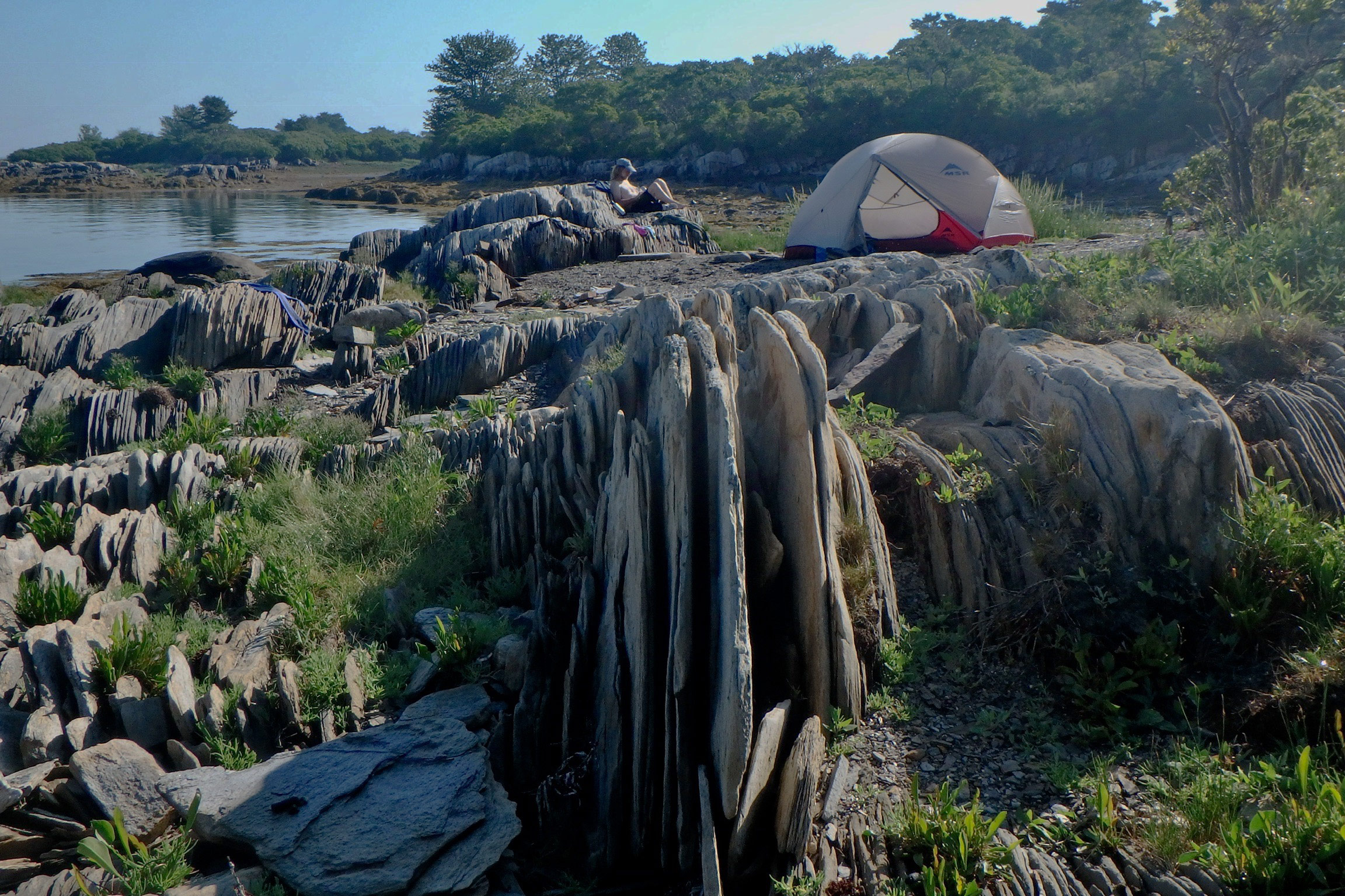
We’d started at Deer Isle, where we had lived and worked for 14 years, and we planned to paddle a big figure-eight: first down to Portland and back, and then up to the Canadian border before returning to Deer Isle. We’d have time to linger in our favorite places and visit many of them twice. It wasn’t until our sixth day of the trip though, when we decided to take a foggy day off and do no traveling at all—what we called a zero day—that it began to feel like the trip we’d imagined. On Ram Island, a tiny islet west of Vinalhaven in Hurricane Sound, I pitched my hammock between a couple of scraggly spruce trees while Rebecca dug her art materials from her kayak. The fog lingered, and the day passed like a dream, the church-like chime of a bell buoy tolling in the wakes of invisible ferries.
The spruce trees atop a granite ledge caught Rebecca’s attention for a 5” x 5” oil on panel, titled “Ram Island”. The scene here is the backdrop in the photograph above of me cooking dinner.
The next day we crossed West Penobscot Bay and traded idyllic solitude for a night at a campground, topping-off our drinking water, recharging batteries and getting our first showers in a week.
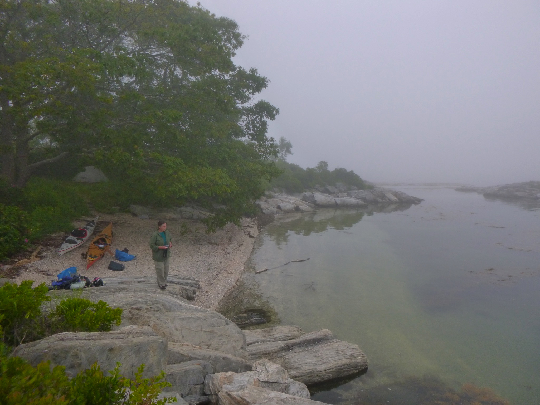
We meandered down the coast, camped on an island off of Tenants Harbor, and then on another in the middle of Muscongus Bay. We’d wake before sunrise, but we were often slow to launch, especially if the island had a good spot for a hammock. If it did, I’d linger with my coffee and catch up on notes and reading, while Rebecca roamed with her sketchbook. Hauling gear and boats down to the water took long enough that, by the time we launched, we’d be a little exasperated by the effort and eager to get moving. We’d paddle a dozen or so miles to the next island. We camped only at designated campsites, most of them stops on the Maine Island Trail.
After another zero day, tucked in the Damariscotta River on Fort Island, we paddled back out the river. Along the way we refilled water containers at the firehouse in East Boothbay, and picked up a few supplies at a convenience store. We could carry almost a week’s supply of fresh water with us, but we always had resupplying in mind. Each day we tried to find food and water along the way to our next camp.
A storm threatened as we crossed Sheepscot Bay on the approach to Reid State Park on Georgetown Island.
With a storm approaching, we let the flood tide give us a push up the Sheepscot River and camped beneath massive oaks on an islet no bigger than a tennis court off of Spectacle Island. The next morning, we headed out the Sheepscot in a cool, soaking rain. At Reid State Park, on Georgetown Island, we passed beneath the rocky bluff of Griffith Head, where a couple of coin-operated binoculars stood like massive silver Viewmasters anchored atop swiveling iron stands, pointing seaward. A few intrepid visitors were afoot up there, hunkered beneath raincoats. We passed below their perch, paddling, for a change, with the wind behind us.
Bangs Island, not far from the Portland waterfront, is one of many Casco Bay islands in with public campsites. Worried about ticks in the taller grass, we camped on the beach and worried instead about the rising tide. Neither the tide nor ticks turned out to be a problem. Despite worrisome news reports about rising populations of ticks and increasing incidents of tick-borne illnesses, we found only a few ticks all summer.
After two weeks of wandering down the coast, we arrived at Casco Bay, intent on getting a glimpse of the Portland waterfront before we turned around and headed back, but with the fog, there wasn’t much to see. The occasional rumble of a ferry out in the soup discouraged us from poking around blindly in busy channels, so we contented ourselves with a few zero days on islands near the city.
There are at least 15 Crow Islands along the Maine coast. This one is in Casco Bay, just off of Great Chebeague Island. Aside from the sandy beach that’s not swallowed up by the high tide, we loved the sprawling oaks, which gave me a good spot for my hammock.
Rebecca painted. I swung in my hammock. We finally made it to Fort Gorges, a granite-block Civil War-era fortress guarding Portland Harbor, and the fog cleared long enough for a glimpse of the city, but we were glad to get back to 100-yard-long Crow Island, with its sprawling oaks and a pair of sandy crescent beaches. And, having made it to Portland, we gradually lost that feeling that there was anywhere else we needed to be.
The water was less chilly here than it was Downeast, and during the afternoon we took occasional swims. I retreated to the hammock to dry in the sun, and we waited for a mid-day change of the tide to begin our trip back east.
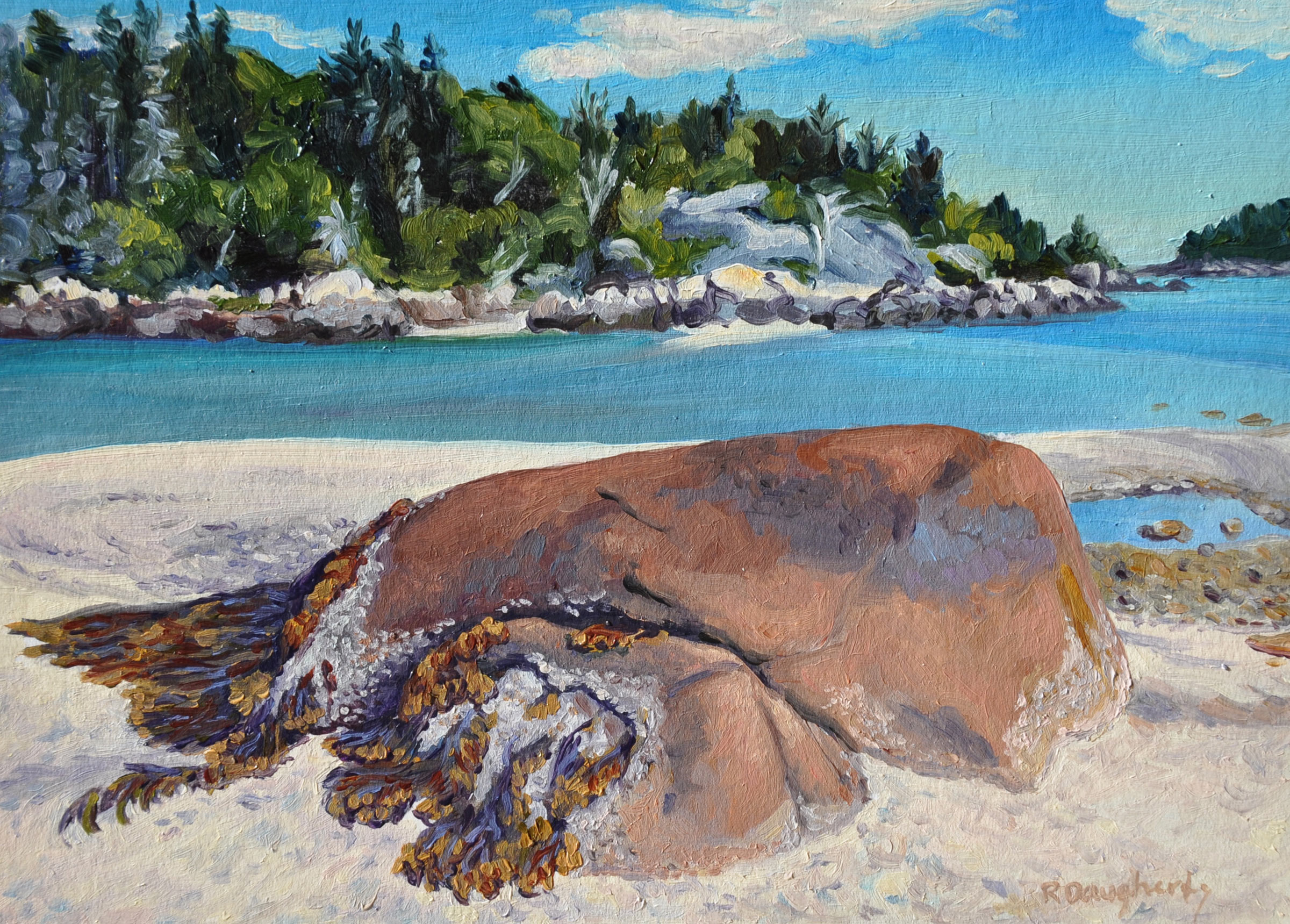
This 5” x 7” oil on panel, “Low Tide Sandbar, Little Hen Islands,” is one of the small paintings Rebecca did on location with the intent of using them as studies for larger paintings.
We zig-zagged along the coast, up the New Meadows River for a visit with old friends. It felt good to rinse-away the salt and grime, to wear dry clothing, socks and shoes, and to eat in a restaurant, but I began to feel uneasy until we were back in our boats the next day, traveling once again. After a night on Ram Island in the Sheepscot, we paddled a long day to Muscongus Bay, and there spent three nights, each on a different island as a storm passed through and left us perfectly poised with calm weather to get out to Monhegan, an island community some 6 miles out to sea from the nearest coastal island.
Eastern Egg Rock, the island we floated alongside, was a treeless hump of rock, only a few acres, ragged with weeds and tangles of washed-up driftwood, and reeking of guano. A heap of lobster buoys lay beside a makeshift plywood sign: TRADE. Next to it stood another sign bearing a red drawing of a lobster. A young woman suddenly emerged from one of two tiny weathered outhouse-like buildings. Carrying a net, she raced down the ledges and swept it over a puffin that had just landed. A young man emerged from the other blind and helped her, kneeling over the captured bird.
A group of puffins swam away from the couple, toward us. The birds were always smaller than I expected, but their beaks looked too big for their bodies, and too brightly colored, like oversized masks colored by a child. We’d followed a string of islands pointing the way to this last solitary rock that separated the mouth of Muscongus Bay from the open Atlantic, and we floated in our kayaks, watching the puffins, sheltered behind the island from the bigger swells beyond. We had about 6 miles of open ocean between us and Monhegan, our next landing, and, at some point, I would need to pee. Landing on Eastern Egg Rock, a bird sanctuary, was prohibited.
We ventured from the lee and paddled into the swell. Monhegan lay on the horizon, but we veered southeast, toward Shark Island—a mile and a half distant— another treeless, fin-like rock pile rising from the depths where the open ocean swells reared and broke through a sieve of jagged rocks and boulders. By now, my plans for a bathroom break had turned into a desperate hope I could get there in time. There was no obvious landing spot, but I told myself I’d made surf landings on rocks before, though not in such a heavily laden kayak.
Rebecca asked, “Are you sure about this?”
I answered by putting my helmet on and aimed for a nook in the lee side of the island where the waves wrapped around and met in a jumble of slippery boulders. Getting out of the boat went well enough, but, ready to paddle again, my relaunching took a few tries as dumping waves filled the cockpit. Finally, I paddled back out, soaked and a little bruised, and came alongside Rebecca. We pointed our bows toward Monhegan.
The swells around us, glassy smooth, reflected cotton-ball clouds. Ahead, a pair of distant blue hills gradually resolved themselves into two islands. Storm petrels skimmed just over the waves, dipping into the troughs; gannets arrived and scared the other birds away.
Soon we could make out the lighthouse atop Monhegan, then the houses below it. Nearing the island, we paused at some ledges where we encountered a pair of kayakers: a boy, followed by his mother, who was paddling with a toddler on her lap. She asked, “Did you just paddle from the mainland?”
“Yeah.” Behind us the mainland was a low, dark line on the horizon above the broad stretch of ocean we’d just crossed.
She sighed. “I’ve always wanted to do that.”
I felt a little pride. I’d always wanted to do it too. And now I had.
After lunch in the village, we paddled around the island, beneath the 150′ cliffs and bobbed in the southeast swell, but we didn’t linger. We still had far to go. There’s no legit place to camp on Monhegan, and the lodgings were out of our budget. Besides, we were lucky to have the good conditions for paddling open water and that could change very quickly. At the north end of Monhegan, we aimed north, across six miles of open ocean toward Allen Island, and the protection of the coastal islands.
The conditions had indeed changed overnight. We woke on a scrubby islet called Griffin Island and rode fat, lively following seas into Port Clyde for a few groceries. We let the wind and waves push us another dozen miles to the campground where we’d stayed three weeks earlier.
By the next day, the weather was perfect again. West Penobscot Bay stretched ahead of us, an undulating plane reflecting a pale sky. Beyond it lay a group of low, dark shapes more than 5 miles away. We pointed our bows toward them and fell into our familiar rhythm.
The persistent mid-tide currents pushed us inland, to the north, but we attempted a straight line by pointing up-current, keeping a range on the faraway cliffs and lobster buoys ahead of us. When we reached a buoy, we’d line up our next range.
In the swells, Rebecca and I often paddled too far from each other to converse, but when she drew near she asked, “What do you want to do when the trip is done?”
I didn’t have a good answer. I’d been gazing at the mirages emerging in the steamy atmosphere. Islands beyond the horizon appeared as if floating in the air like clouds.
We had both worked long and hard to be able to take a summer off and take a trip like this one, but we hadn’t talked much about what we would do afterward. September hung beyond the horizon like an island we couldn’t yet see, and most of the time we just focused on what was in front of us.
“Right now,” I said, “I don’t want this trip to end.” Rebecca smiled.
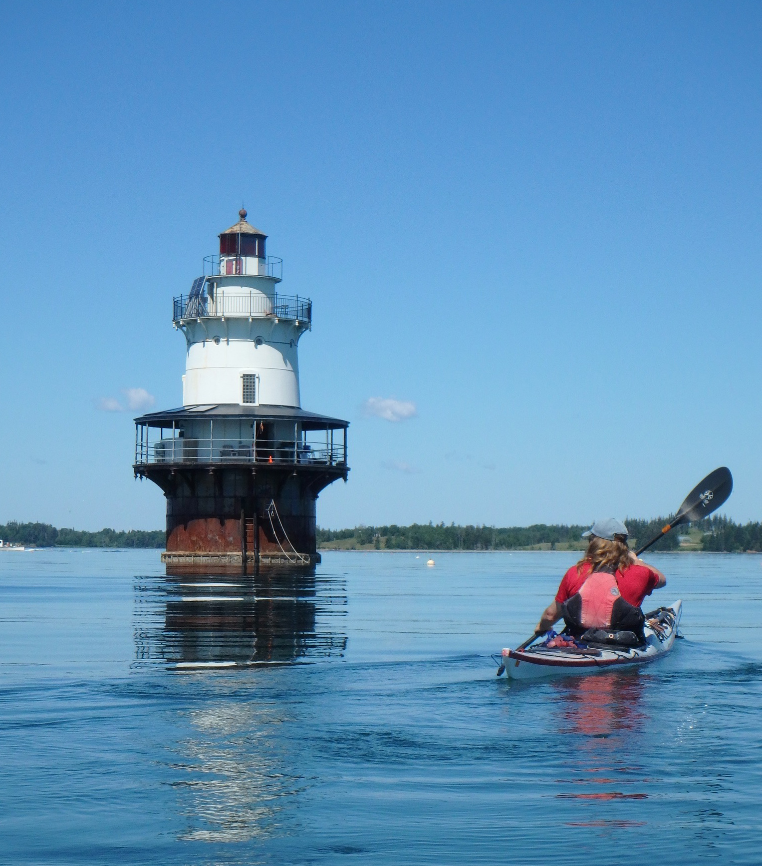
Goose Rocks Light, built in 1890 at the entrance to Fox Island Thorofare, north of Vinalhaven, is one of several “spark-plug” lighthouses seen along the Maine coast. It is still an active navigational aid maintained by the Coast Guard, but it’s now owned by a non-profit that maintains it with funds generated by nightly rentals.
We spent three nights camped on islands around Vinalhaven, and then took the long way back to the Stonington archipelago, crossing the mouth of East Penobscot Bay and circling Isle au Haut, before paddling 1-1/2 miles to Harbor Island, a 6-acre knot of woods fringed by gentle slopes of gray granite. From our camp we could see the familiar glow of Stonington in at the northern edge of the night sky.
South Little Hen Island lies off Vinalhaven in Seal Bay, a popular anchorage. We took a zero day here and idly watched cruising boats come and go.
The next day, paddling toward our home town after a month of kayaking reminded me of so many other times I’d returned home from countless shorter paddling excursions. But we weren’t returning home. We were stopping only briefly for fresh water and whatever groceries we could scrounge from the shoreside convenience store. We dropped in at the library, just across the street from the water, to say hello to the librarian, a friend of ours, and she passed along a massive zucchini that someone had left her—a dubious gift in summer when everyone with a garden has more zucchini than they need—but it would feed us for the next couple of days.
After another night in the Stonington archipelago, we crossed Jericho Bay in the fog to Marshall Island, the largest uninhabited island on the eastern seaboard. We camped with some friends, and the next day paddled with them north. We left them finally and turned toward Greenlaw Cove, where we’d begun our trip more than a month earlier. We spent the next couple of nights in the guest room of the friends who’d loaned us their cabin over the previous winter. In between rinsing our gear and picking up groceries, we were immersed in our hosts’ busy summer social life, taking another guest for a paddle, and chatting for hours over brunch. I became increasingly restless, and when Rebecca and I were finally on the water again, it felt like a miracle. We hurried the 10 miles across Blue Hill Bay, island hopping to the south end of Mount Desert Island.
A crowd lined the rails of the walkway below the lighthouse at Bass Harbor Head, and farther down they dotted the steep rocks with splashes of color like confetti, which, as we paddled closer, turned out to be visitors at Acadia National Park. We paddled close to shore, alert to waves that lifted us as they passed and crashed into the rocks. People waved at us as we passed and Rebecca, always polite, waved back. I felt awkward, as if I’d joined a parade, and focused on my paddling.
Beyond the lighthouse, there were no crowds and on an isolated stretch of the bare granite shoreline we saw a man, alone, stepping from rock to rock. He shielded his eyes from the sun to watch us pass. I thought of him as a traveler like us, and waved.
Some islands have only a thin layer of soil supporting a dense spruce forest, like this one in Pleasant Bay.
Beyond Mount Desert Island, the coast was more remote, with geographical features named for the ships or sea captains who had foundered on them. Halifax Island, 7 miles northeast of Jonesport, was named for the British schooner that broke-up on the rocks there. Baileys Mistake, a harbor 6 miles from the Canadian border, was named after a Captain Bailey who ran his lumber schooner aground at the harbor entrance; rather than face his employers back in Boston, he and his crew settled there, building homes with the ship’s cargo. This coast is steeped in such mythology. The lighthouses along this stretch of the coast speak of fog, shipwrecks and loneliness. The tides and currents are more extreme, and the sea is less predictable here and intimidating, but this coast felt larger than life and there was something about it that resonated with me. I felt at home.
Campsites were scarce, and we paddled longer days to get to them. We rounded peninsulas that jutted into the sea far from the villages that lay at the heads of long estuaries. In Jonesport we filled water bags and bought what useful things we could find at the shoreside variety store. Everyone we met looked right at us, smiled, and said something encouraging. We paddled 11 miles to Ram Island, a grassy hilltop barren of trees, inhabited by a pair of black-faced sheep who tolerated us from a distance. From our camp on this 1/4-mile long speck of land, the broad expanse of the Atlantic stretched to the south beneath a vast, empty sky. We watched the sun dwindle into the horizon clouds and almost immediately the fog appeared, further separating us from all we’d left, reducing our world to a hump of grassy rock.
As the sun set on Ram Island, Rebecca painted the islet’s moss-draped trees. The longer we spent in a place, the more Rebecca found to paint.
At around noon, the fog surrounding Ram Island finally cleared and we could see Cross Island, four miles distant and rising from the peninsula beyond it north, of 26 radio towers, some nearly 1,000′ high, built by the Navy to communicate with submarines operating in the Atlantic.
We got to Cross after an easy paddle: a welcome break, since our next day would be the toughest. Cross Island was the last stop before the Bold Coast, a 20-mile stretch of formidable, cliffy shoreline overlooking the Grand Manan Channel, known for its tricky currents and lack of places to land. From our campsite, we planned our moves for the next day and stared out across the narrows, where the fog had obscured all but the tops of the enormous radio towers, their red lights pulsing through the gloom.
In the morning, already shivering from a steady rain, we paddled across the narrows and headed northwest along the Bold Coast, passing seals flopped upon ledges like beanbag toys. The current was against us, so we stayed near shore, following a twisting path of rougher water where the back eddies could help us along. The near-shore rocks formed rockweed-draped mazes; cliff-lined slots rose up into the clouds. “You warm enough?” Rebecca asked.
“Yeah,” I said, but mostly out of habit. I was looking forward to our break. After nearly three hours in our kayaks, we finally landed at a cobble beach just before Moose Cove – just long enough to get into dry clothes and eat.
By now, the tide had turned and the flood’s current would be in our favor, but strongest well offshore. We lingered below the cliffs that rose straight up from the sea to disappear into a layer of fog. At the head of a rock-strewn cove lay an old wreck of a fishing boat. Layers of orange-red paint had peeled away from a bow and its stern had been torn off, presumably by the storms that pummel this shore. A quarter-mile offshore a whistle buoy hooted; we could barely see it.
The fog was always thick when we passed through Quoddy and Lubec Narrows. This time we had a strong current behind us that buoyed us quickly past the Lubec Channel Light.
We finally left the shore and paddled east into the fog to catch the current, leaving the cliffs in the mist behind us. The lighthouse at West Quoddy Head lay invisible five or six miles distant. The lobster buoys showed us the direction of the flow, and we aimed toward the ones with the most vigorous wakes. Occasionally we could hear waves beating the shore, and we steered more seaward. The grumble of a distant lobster boat reached us, but we saw only the gunmetal surface of the sea beneath the fog. After an hour, pushed by the 3-knot current, we arrived at West Quoddy Head.
The lighthouse there sits on the easternmost point of the United States; it is painted in horizontal red and white stripes, but without the red it would have invisible through the fog.
The hidden sun infused the fog with a pale, amber glow as we followed bearings from the lighthouse northwest into Quoddy Channel and then struggled against the ebbing current in Lubec Narrows, the 300-yard-wide gap between the Maine mainland and Canada’s Campobello Island. I’d powered past the breakwater, but Rebecca went to the Canadian side to ride an eddy and hugged the shore until the current lessened, and we met at an island up-current. Surrounded by fog, we searched out eddies to help us on our way.
Shackford Head was a shoreline of dark cliffs that we kept close by to avoid the standing waves just offshore. I’d hoped then we’d be able to see Sumac Island, where we’d camp, but the fog was still too thick. I would need to dig another chart out of my day hatch to get a bearing. It was only a mile away. We drifted for a moment, sipping water, and then, just like that, the fog lifted. One moment we looked out into a dense wall of it, the next we easily identified the small island where we would camp.
I put my water bottle away and took a bearing off the deck compass, in case the fog returned, and we dug in for one last stretch– our 34th mile for the day.
Sumac Island has about as much area as a two-car garage, with barely room for our tent amid the trees and fragile vegetation, but it would be home for a needed rest day. In the morning, we lingered in the tent, listening to drips of condensed fog falling from the trees and tapping on the fly. I opened the vestibule and gazed out at the miniature terrarium world of the forest floor, the princess pine and British soldier lichens, and plush, bright mosses. Beyond that was dense fog. I crawled outside and stretched.
After two nights on Sumac Island in Cobscook Bay, we went into Eastport, hoping to continue across to Deer Island, in Canada. Unfortunately, the customs office there had closed—but we were happy enough to return for a third night on Sumac, before turning around for the last leg of our trip.
With the tide out, Sumac Island stood like a small mountain of dark, angular rock, draped with rockweed. Atop it lay about 4′ of black, loamy soil, held in place by roots; in its interior is a secret garden thick with delicate, ankle-high flowers and greenery sprouting from the pine-needle duff. We tiptoed carefully around it, stepping only on logs and rocks.
I climbed into the hammock with my coffee. A metal skiff motored past, then pulled up onto the ledges. The skipper stepped ashore and wandered among the seaweedy boulders, bent over at the waist, collecting periwinkles. A beat-up aluminum canoe arrived next, with a man sitting in the stern steering with a small outboard motor. Black handles of clam baskets arched above the gunwales. It was Sunday morning. The fog gradually thinned, revealing houses and low, rolling pastures on shore. Later, we paddled the 3 miles to Eastport, where we spent the day replenishing supplies.
The next morning we paddled into a thick wall of fog at Shackford Head and caught the ebb that carried us back beneath the Roosevelt International Bridge in Lubec, where the din of the rushing current echoed through the quiet town. We let the tide take us past West Quoddy Head Lighthouse, and out into Grand Manan Channel. The land soon disappeared behind us in the fog. Heading back down the coast, we’d begun the last leg of our trip.
Miles from an invisible shore, we watched the water surface for clues, looking for the strongest current to push us back down the Bold Coast. But we had different ideas about which way we should go. I favored the magnetic bearing that roughly paralleled a route south along the coast. Rebecca, wanting as much help as possible from the current, veered seaward, paddling away from me until she nearly disappeared into the whiteness. With more than 30 miles to paddle that day, we needed help from the current, but I worried about getting too far out to sea. Still, with my wife about to disappear altogether, I abandoned my bearing and followed her. Together we watched for lobster buoys, the only indicators of the speed and direction of the current, and every now and then we’d hear the muffled thunder of surf and adjust course to paddle farther offshore. A lone puffin found us and circled overhead a while before flying off into the fog.
Rebecca paused and cocked her head. “Hear that?” I couldn’t, but she described the hooting of the whistle buoy off of Baileys Mistake, a 3/4-mile-wide bay on the mainland. A mile off maybe? Two? Again, we adjusted our heading offshore and we encountered great floating rafts of rockweed and other surf wrack, and guessed that it had drifted out of Baileys Mistake. After a while, we paddled into another patch of debris, and it made sense that it had probably floated out of Moose Cove. The current had slowed though, and we soon found lobster buoys bobbing over slack tethers. We’d paddled into Grand Manan Channel nearly three hours earlier, and now the tide was changing direction. We took a bearing toward shore.
Ram Island in Machias Bay feels far more remote than it is, only 1-1/4 miles off the nearest mainland point. Now owned by Maine Coast Heritage Trust, the island’s vegetation is kept in check by a pair of semi-wild sheep. In the distance to the east, Libby Island Light is one of the foggiest in Maine, and the site of numerous shipwrecks.
We camped again on Cross Island, our second night gazing across the channel at the slow pulse of red lights marking the grid of the Navy’s radio towers, and in the morning, foraged blueberries in the meadows around the old lifesaving station. Any island we camped on for more than a night became a favorite, hard to leave, but we finally set-out, across Machias Bay and into Little Kennebec Bay, borne inland on a bumpy ribbon of quick current, finally following a narrowing maze of channels into a secluded tidal pond. Here we would spend another two nights, taking shelter from strong winds and seas, and visiting Dickinsons Reach, a now vacant community of remote wooden yurts built by simple-living guru Bill Coperthwaite and his like-minded friends.
The current carried us back out to sea, and we wove through the Roque Island archipelago on our way to Jonesport, where we again resupplied at the variety store and, as a downpour began, let the current buoy us down Moosabec Reach.
The next morning, on Sheep Island, we sat at the picnic table, gazing at the chart spread before us with rain pattering down on the dining fly over our heads. We were having our second round of coffee. Fog had been coming and going, sometimes enveloping us completely, but then drifting away to reveal the shore of Cape Split or the distant islands. But it was dry beneath the rain fly, and even a little warmer, and we had enough water to make hot drinks all day long.
It was Saturday morning, and we could see all of the probable moves to get us back home to Stonington by Thursday or Friday. We measured the distances on the chart with a string, guessing where we might paddle each day, and which campsites we might get to each evening. We stared at the chart. I wanted to finish what we’d set out to do, but I didn’t want the trip to be over.
“Well,” Rebecca said. “We can come back any time.”
“Sure.” But our schedule wasn’t the only thing that would change. The air already felt cool, as if autumn were upon us. This trip would soon be in the past. Maybe that’s why we were taking another zero day. We could have paddled in the fog and rain, but we liked the island; we even had a privy and a picnic table. Most of all though, we wanted to preserve this feeling of being in our own world and feeling at home in it. Over the last 50 days we’d fallen into a rhythm that doesn’t come on a weekend outing. And the feeling of home came easier when we had no home elsewhere.
Not much more than a ledge, Dry Island in Gouldsboro Bay was true to its name the night we were there, and remained dry, though I woke before high tide just to be sure. Legit camping options are scarce between Frenchman Bay and Petit Manan Point, so we took what we could get.
A group of paddlers in orange and yellow tandem kayaks came around the end of Sheep Porcupine Island, flying along downwind, some with their paddles held aloft to catch the breeze. The frontrunners came abreast of us, shouting like kids on a carnival ride.
Mammoth cruise ships lay at anchor off Bar Harbor, their shuttles zipping back and forth, and a couple of bloated motor yachts were parked in slips at the public dock.
Though Bar Harbor is known for its cruise ships and crowds of tourists, we could usually find a stretch of steep shoreline not far from town for ourselves, like this one along Long Porcupine Island.
We pulled the kayaks onto the sand and headed into town. Rebecca and I had lived outdoors for the summer, crouched on rocks while we cooked, and slept on the ground. My clothes were stiff and streaked white with salt; my tan tinted with grime. The sidewalks were filled with ambling tourists flowing in and out of restaurants, gazing into shop windows. When they caught sight of me, they quickly looked away.
I longed to get back on the water, and I dreaded the end of our trip.
We spent our last night on The Hub, a tiny island, lying out on the warm granite slabs, watching stars and satellites until we could no longer keep our eyes open
On the hottest day of the summer, we paddled across Blue Hill Bay and back into the orbit of Deer Isle, closing the loop that had taken us over 600 miles and nearly two months. As we approached our take-out at Stonington, the heat was replaced by a cool north wind and we paddled hard just to stay warm, as if the season had turned the corner in a single day. We lingered in our boats and pulled alongside each other. We were looking forward to showers at the campground, clean clothes, and a dinner at a restaurant in town, but we were in no hurry. We’d lost whatever sense of hurry we’d had at the beginning of the summer, but knew that would begin to change the moment we landed. We looked at each other. We were both salty, dirty and exhausted, a little gaunt around the cheekbones, but all that only made our smiles brighter.
Michael and Rebecca Daugherty are back in Stonington operating a kayak guide service. Michael is the author of AMC’s Best Sea Kayaking in New England, and Rebecca has a studio and gallery. They paddle out to the islands as often as they can. A book-length version of this story, illustrated by Rebecca, will be available soon.
If you have an interesting story to tell about your adventures with a small boat, please email us a brief outline and a few photos.
Nathaniel Holmes Bishop III was born in Medford, Massachusetts, on March 23, 1827, and died in Glens Falls New York, July 2, 1902. In his time, he was quite well known for books he had written about his travels in small boats. I first heard about him, quite by accident, in the spring of 1982. I was working part-time at the Wooden Boat Shop, located, appropriately, on Boat Street in Seattle. On a sunny summer morning, I was manning the front counter when the mail came in and among that day’s mail was the latest issue of Wooden Canoe, Volume 11 of the Wooden Canoe Heritage Association’s magazine. The store was empty so I had some free time to browse through it.
This issue of Wooden Canoe introduced Nathaniel Holmes Bishop to me. Eight years later my son would be named Nathan in his honor.
I skimmed over an article written by Walter Fullam of Princeton, New Jersey about building canoes by laminating kraft paper with glue. That was mildly interesting, but what captivated me was an excerpt from Bishop’s Voyage of the Paper Canoe: A geographical journey of 2500 miles from Quebec to the Gulf of Mexico, during the years 1874—5. Hungry for the rest of Bishop’s story, I found an old copy in the University of Washington’s library and read it from cover to cover. His writing was certainly a product of the 19th century, but charming and evocative:
Finding that the wind usually rose and fell with the sun, we now made it a rule to anchor our boat during most of the day and pull against the current at night. The moon and the bright auroral lights made this task an agreeable one. Then, too, we had Coggia’s comet speeding through the northern heavens…. In this high latitude day dawned before three o’clock, and the twilight lingered so long that we could read the fine print of a newspaper without effort at a quarter to nine o’clock P. M.
And he did not lack a good sense of humor. About his parting with David Bodfish, his traveling companion, briefly, from Quebec City to Troy, New York, he writes:
I had unfortunately contributed to Mr. Bodfish’s thirst for the marvellous by reading to him at night, in our lonely camp, Jules Verne’s imaginative Journey to the Centre of the Earth. David was in ecstasies over this wonderful contribution to fiction. He preferred fiction to truth at any time. Once, while reading to him a chapter of the above work, his credulity was so challenged that he became excited, and broke forth with, “Say, boss, how do these big book-men larn to lie so well? does it come nat’ral to them, or is it got by edication?
Having grown up on the West Coast, I knew about the Inside Passage woven into the coasts of British Columbia and Alaska, but I had no idea that there was an even longer and better protected thread of waterways that connected Canada to Florida. After I returned Voyage of the Paper Canoe to the library, I paid regular visits to the book with a weighty pocketful of nickels and carefully photocopied every page of it. I needed to have a copy because I’d decided, even before I’d finished reading the book, that I would build a paper canoe and retrace Bishop’s route. He would be my guide. I was approaching 30, not quite sure what I was going to do with my life, and had no obligations to prevent me from embarking on a voyage that would take several months. I spent the next year trying to figure out how to laminate a paper hull, and in the late fall of 1983, with a craft-paper canoe of questionable durability on my Volkswagen bug’s roof racks, I headed to Quebec City. Four months later I had reached Cedar Key on Florida’s Gulf Coast. The voyage had only whetted my appetite.
I kept my copy of Four Months in the chart case and kept up with Bishop day by day as I descended the Ohio River and then the Mississippi with him. Not all of the landscape had been changed by the 110 years between us. Cave-in-Rock, a 30′ wide cavern on the Illinois side of the Ohio is still there, as is the burial mound in Moundsville, West Virginia. And most of the Mississippi is isolated from civilization by levees so it’s the same wilderness the Bishop rowed through and the people who live along the river were every bit as interesting and generous as they had been in Bishop’s account.
I made good time, especially along the Gulf Coast where I had some good sailing, and reached Cedar Key in 2-1/2 months. Although my pursuit of Bishop was suddenly over, he had given my life a new and clear trajectory, one that eventually lead me here, to Small Boats Monthly.
Of the last night of his voyage, Bishop writes:
Lying there under the tender sky, lighted with myriads of glittering stars, a soft gleam of light stretched like a golden band along the water…. It seemed to be the path I had taken, the course of my faithful boat. All I could see was the band of shining light, the bright end of the voyage.
What he had seen behind him, that bright path, was what I had seen stretching out ahead of me.
Bishop was traveling and writing long before his well-known voyages. This journal, dated 1852 and written when he was 15, is titled “Nathaniel Bishop’s Journal of a Pedestrian Tour from the Town of Medford, Mass, to the White Mountains, N.H., Embracing nearly 300 Miles Travel on Foot.” He also kept a journal later in his life called “Log of the Lorna,” an account of travels by boat with his wife, Mary Ball. I saw this journal, and other Bishop memorabilia, in the archives of the Ocean County Library, in Toms River, New Jersey.
The two routes, paper canoe on the right and sneak box on the left, both end at the Cedar Keys on the Gulf Coast of Florida. Together they add up to more than 5,000 miles.
Bishop travelled from Quebec City to Troy, NY, in a lapstrake double-ender, MAYETA, an 18′ lapstrake canoe, which proved too heavy and unwieldy. Bishop had heard about the tough, lightweight boats being made of paper by Waters & Sons, the only company making paper boats, as well as observatory domes and racing shells. The company was in Troy, so he ordered a paper canoe. This letter, dated October 12, 1874, seems to be an announcement of the completion of the canoe. Nine days later, having christened the 58-lb canoe MARIA THERESA, Bishop resumed his trip southward on the Hudson River. George Waters, paddling his own paper canoe, accompanied him for a few miles.
Bishop’s paper canoe became a selling point for the Waters company. His books were quite popular and often given out a prizes to school children.
Bishop rowed MARIA THERESA through southern waters in February of 1875, and the cool weather would have kept the insects at bay and made the alligators sluggish.
News of the Voyage of the Paper Canoe raced down the East Coast ahead of Bishop. The town of St. Marys, Georgia, awaited him with this elaborate document, “An Address of Congratulation and Welcome from the Inhabitants of St. Mary’s” that was presented by the city’s mayor.
This undated photograph of Bishop paddling MARIA THERESA is the only photograph I’ve seen of that famous paper canoe. Bishop spent most of his time rowing instead of paddling; the outriggers are here folded back to rest on the deck. [Update: Ken Cupery, who once published The Paper Boater (no longer being issued but selected articles appear in Ken’s website, www.cupery.net), notes that the boat pictured here is not MARIA THERESA, which had a much longer cockpit. The photo has no notations and the boat’s identity is unknown.]
After I’d paddled MARIA THERESA’s route from Quebec to the Gulf of Mexico, I caught up with Mr. Bishop at the Riverside Cemetery in Toms River. That was in January of 1984. Two years later I’d be back on his trail, close to finishing my retracing of his sneak-box voyage.
Traffic on the Mississippi River has changed over the last 143 years. In 1876, Bishop’s sneak box, CENTENNIAL REPUBLIC, may have been among the smallest boats on the river, but she was certainly not the slowest.
While Bishop was spending the night in New Orleans, he was discovered by “roughs” and taunted while he was trying to sleep. Having the benefit of his experience, I spent my night in New Orleans tucked deep under a large pier where no one could see me.
The Gulf Intracoastal Waterway wasn’t fully developed in Bishop’s day. Where he had to travel overland, there are now canals.
Bishop traveled 2,600 miles aboard CENTENNIAL REPUBLIC. The route from Pittsburgh to Cedar Key is now almost 200 miles shorter.
When I left New Orleans on a foggy Mississippi River, I had followed Bishop’s two long voyages for 4,500 miles and had another 400 miles ahead to get to the finish at Cedar Key, Florida. In the end, it was over all too soon.
Walter Fullam, whose article on paper canoes helped me build mine, shared with me an abiding interest in Bishop. After I finished my sneak-box journey, I built this model of Bishop’s CENTENNIAL REPUBLIC for him. We remained friends until his death in 2000 and his wife Dorothy and I sent each other Christmas cards for many years afterward.
Bishop did quite well for himself in his later years. He was a successful cranberry farmer and owned over 60 plots of land as well as homes in New Jersey, New York, Florida, and California. In 1880 he was among the two dozen paddling enthusiasts who founded the American Canoe Association. I found this portrait of him in Toms’ River, in the library he funded in his will.
Canoeist Bill Burk, in an article linked to the Moccasin 14 page of the B&B Yacht Designs website, writes that he had built a Moccasin 12 and enjoyed it for day use and fishing but needed something larger to take canoe-camping at lakes in the Pacific Northwest. Regulations at the Bowron Lakes in British Columbia required at least 16″ of freeboard, Ross Lake in Washington State limited length to 14′, and Bill anticipated carrying up to 120 lbs of gear, setting the displacement at 350 lbs. That established the design criteria for Graham Byrnes, and he drew up what would become the Moccasin 14.
Opening photo Graham Byrnes, this photo Christopher Cunningham
The five pieces of CNC-cut plywood for the hull are joined with these sawtooth finger joints.
B&B’s Basic Kit for the Moccasin 14 includes a 24-page manual, illustrated with drawings and photographs, and the plywood parts for the hull and paddle blades, all CNC-cut from 4mm plywood. The hull is made from five precut pieces: a center panel and four identical end panels. Each end panel incorporates half of a side panel, one side of the bow or stern, and the end of one side of the bottom. Finger joints, slathered with epoxy, hold all five pieces together. After the epoxy has cured, the joined pieces lie in a flat plane, ready to fold into shape.
Christopher Cunningham
The forward end of the chine transforms from a pronounced angle to a smooth curve.
The center seam at the ends is stitched together with cable ties, bringing the ends from flat to vertical. The sides, now splayed out, get stitched next. The chines have interlocking tabs that assure exact alignment, so there’s no fussing with an edge-to-edge contact and poking at wired ties. Pulling the chine joints tight forces shapely compound curves in the ends of the hull, and the side panels eventually meet amidships to get connected with plywood butt blocks.
Christopher Cunningham
The plywood doubler that spans the area between the two thwarts reinforces the seating area.
At this point the hull is hogged, and that’s where a building a cradle comes in. It’s one of the many add-ons to the basic kit and will assure the hull takes its proper shape. The center of the cockpit gets a second layer of plywood, and as that doubler is glued in place, screws driven along the centerline pull the hull down to the cradle’s long wooden I-beam. When removed from the cradle, the hull has a straight keel.
From this point on, the canoe’s completion is standard boatbuilding. Breasthooks, inwales, outwales, and thwarts can be cut to patterns in the basic kit or purchased as an add-on, ready for installation. A keel, epoxied to the bottom, protects the hull from gritty shores and gives the hull better tracking. The plywood paddle blades, supplied with the basic kit, take on a curve when glued to the paddle shaft, also supplied as a pattern or as a factory-shaped piece.
Christopher Cunningham
The seat, provided as an add-on kit, is a worthwhile addition for the comfort and paddling efficiency it provides.
The seat is sold as an optional kit, and I’d recommend adding it to your order. Sitting on the hull puts you too low for comfort or power, and cushions make a sloppy connection to the boat. The B&B plywood seat is set at a comfortable angle and high enough to put your hips higher than your heels—much better than sitting with your legs straight out—without compromising stability. The seat’s frame is contoured to pull the seat top into a single broad curve at the back, providing relief for the tailbone, and a double curve at the front to cradle the legs.
Christopher Cunningham
The broad pivoting backrest offers comfortable support.
While the kit doesn’t include a foot brace, you could, and should, take a cue from the backrest mounts and set a stretcher from side to side, high enough to meet the balls of your feet. With a foot brace, you can press yourself into the backrest, stay locked in the seat, and paddle with more power.
The canoe is light—it should come in at 38 lbs—so it’s easy to carry. The inwale provides a good grip for a solo carry with the canoe hung over a shoulder. The seat isn’t secured in place, but it will rest against inside the canoe, kept from sliding out by the inwale. Adding a yoke to put the weight on both shoulders with the canoe overhead would be a good shop project if you have in mind to do canoe tripping with long trail portages. For a tandem carry, the breasthooks offer good handholds.
Christopher Cunningham
The inboard ends of the paddle blades are shaped with a small lobe that sheds water before it can run along the shaft and get the paddler’s hands and lap wet.
When the canoe is sitting in the water, the seat is set between to two long cleats that center it and allow fore-and-aft adjustments. With a paddler’s weight on the seat, it stays put. I could make adjustments by pushing down against the hull with my knuckles to unweight the seat and scooting it where I wanted it.
The backrest has three positions to get the paddler in the right place for proper trim. The aft setting was appropriate for my 6’ frame. The backrest’s curved plywood panel was comfortable and provides good support down low where it doesn’t interfere with torso rotation during a full, powerful stroke. The seat was comfortable too, and if I’d had a foot brace I could have added a bit of leg drive to the stroke, pivoting my hips slightly in the seat.
The Moccasin 14 is rated to carry an adult and one or two kids. With my 200+ lbs aboard, the canoe had about 8” of freeboard, and with a beam of 28″ the gunwales weren’t so high that I had to reach over them. I could paddle with a low, relaxed stroke. The initial stability was a little soft, but very good given the 28″ beam. I was quite comfortable taking my hands off the paddle to take notes. The secondary stability kicked in quickly and reassuringly when I edged the canoe.
Underway, the Moccasin tracked well and didn’t yaw excessively between strokes. Turning in place through 360 degrees took 14 strokes—seven forward on one side, seven backing on the other. The keel makes the canoe favor tracking over quick maneuverability, appropriate for a canoe designed for tripping, traveling lakes and slow-moving rivers. The Moccasin took well to being sculled sideways; it was a fun way to maneuver.
Graham Byrnes
Putting the power on, the author was able to push the Moccasin at 5-1/3 knots. It maintains good trim even at speed.
Equipped with a GPS, I did some speed trials. I could easily sustain 3-1/2 knots at a relaxed cruising pace. Working up to an aerobic exercise pace brought the Moccasin to an average of 4-1/3 knots. Paddling all-out for a few dozen yards, I did 5-1/3 knots. At top speed, the canoe stayed in good trim and its stern didn’t squat.
I didn’t have much wind during my two trails, just 8 knots. Paddling across the wind, I didn’t detect any weathercocking. I’d take a course across the wind, stop paddling, and watch the bow; it didn’t veer to windward. There were no waves or wakes, so I could do any rough-water testing, but, as an open canoe, the Moccasin 14 would have limits to the amount of chop it could handle. For lake tripping where adverse weather could make the going sloppy, spray decks and flotation, either as built-in airtight compartments or float bags lashed in place, would be in order.
The Moccasin 14 has an unusual construction that makes for a quick build and a shapely hull. And while it was designed for cruising with a big load of camping gear, unburdened it’s quite playful. It could make use of those brief windows of time when there’s a break in your schedule and the weather, and just as ably turn a vacation into a memorable adventure.
Christopher Cunningham is editor of Small Boats Monthly.
Moccasin Particulars
[table]
Length/14′
Beam/28″
Height/11.5″
Weight/38 lbs
[/table]
The Moccasin 14 kits are available from B&B Yacht Designs. Prices range from $415 for the Basic Kit, with just the plywood pieces, to $1,025 for The Works, with everything you need to complete the build, ready for paint or varnish.
Is there a boat you’d like to know more about? Have you built one that you think other Small Boats Monthly readers would enjoy? Please email us!
After seven days in equatorial Africa I was still acclimating—the hazy air had weight. Ten days earlier I was at home chopping firewood in the snow in New York; now I was walking a dusty road and drained by the sweltering sun. Ted Cooney, Brent Simpson, and I made up a three-man caravan. Ted and Brent had just finished their two-year stints as Peace Corps volunteers in the Republic of Zaire, now known as the Democratic Republic of the Congo, and were more at home in the unrelenting heat. The three of us had spent the last two days in the mission town of Bulape, Zaire, making preparations for the march overland to the Sankuru River, where we would find the pirogue that we’d paddle downriver to the Kasai and Congo rivers.
As college roommates in Maine, Ted and I had canoed and camped together and following his Peace Corps posting to the Kasai province of south-central Zaire, we corresponded often by mail. In August 1985, Ted wrote a letter from his mud hut in the town of Demba saying he had ridden his motorcycle “to a village 150 km from here to the north on a big river called the Sankuru. The last 20 km I had to have a guide to show me the way and to help pull and heave the moto over fallen trees on the forest path. The village is Bongongo, about 30 km upriver from Kilendjale, if you can find that on your map. They have the rep of being the best pirogue makers in the area. In short, I put in my request for a large boat and three paddles, delivery to be taken on or about January 20, ’86. The trip downriver is all flat water for approx. 600 miles (three to four weeks max). However, one must bear in mind that the trip will involve the navigation of the confluence of some of the world’s largest rivers—Sankuru and Kasai, Kasai and Zaire. The section spent on the Zaire is but a few days at best….”
Ted was recruiting Peace Corps pals to join in and hoped I could make the trip too. So, in February 1986, Brent, Ted, and I were retracing Ted’s route from Bulape to Bongongo.
Tom DeVries
Brent Simpson, Ted Cooney, and Tom DeVries, (left to right) out in the noonday sun, were eager to find some shade on the two-day overland hike to Bongongo.
Heading out at 5 a.m. gave us a few hours’ refuge from the sun. We’d walked for an hour by flashlight, passing a village singing and drumming in mourning for a recent death, exchanging moyos—greetings—with hunters heading for the Bulape meat market with bloody monkey haunches, and passing a group of uniformed children making their way in the dawn light to the mission school. Two hours later, we climbed up into the bed of a big truck heading 45 miles along our way on the rutted, sandy road. At a fork in the road, we parted company, payed the driver, and continued by foot to the Lubudi River. There, a ferryman got us and our packs settled low in his pirogue and paddled us, herky-jerky, across the racing current. That wobbly ride left us a bit apprehensive about what lay ahead. Brent and I both groused to Ted, “Man, I hope our boat’s a hell of a lot more stable than that!”
Back on the trail, we trudged along, pack straps wearing grooves in our shoulders. The sun bore down relentlessly. That night, completely burned out, we threw down camp on the top of a sweeping savanna that commanded the green and brown hills of Kasai. By seven o’clock we were under mosquito nets on the hard ground listening to the bugs click and buzz and gazing at the dazzling diamonds in the African night sky. At 4 degrees south latitude, a 12-hour night follows a 12-hour day year-round, so we got a long night’s rest following our hard day laboring under the sun.
Roger Siebert
.
The next morning, we followed the single-track trail off the grassy highland, across plains and through forest, occasionally passing a lone walker or a few grass huts. In one parched village there was a single tree centered in a bleak, boulevard-wide dirt plaza. Under the shade of the tree lay a bony, frothing dog. We beelined for the shade, dog be darned, and guzzled our water jugs. No one else stirred in this high-noon ghost town. Farther on there was cool water at a tree-lined stream swarming with thousands of blue and green butterflies. There were also nipping bees that found Brent and Ted, so we scrambled out of there. We guessed that the bees were attracted by the salt in the sweat on their shirts. The bees didn’t sting me. I hadn’t sweated all day. I was bone-dry dehydrated.
My mates were a bit concerned about me and tried refreshing me with mental popsicles by reciting, among other gems, “The Cremation of Sam McGee”:
There are strange things done in the midnight sun by the men who moil for gold; The Arctic trails have their secret tales that would make your blood run cold.
I was more apt to conjure dismal images from Heart of Darkness, Joseph Conrad’s novel about a brutal voyage up the Congo River, than from Robert Service’s story of sourdoughs freezing on the Klondike, but it was good diversion just the same. My shirt was finally as soaked as theirs after a most welcome afternoon storm that drenched us sideways and pelted us with hail.
As we neared Bongongo, we started seeing more people on the path. Passersby greeted us with grins. It seemed to me they were whispering, “It’s them.” Someone passed around some palm wine. Someone else ran ahead to announce our arrival. We crossed a final bridge and entered the village as night fell. We had made it to the Sankuru! We were greeted as welcome guests. I drank water like a draft horse, met our hosts, and faded off to sleep.
Tom DeVries
It was wonderful to watch ALICE MAY get a final fairing. A few of the boys made a little money selling us their slingshots.
In the morning we got our first look at the pirogue Ted had commissioned. The barefoot, barrel-chested boatbuilder was still whacking out chips with his adze. The boat, a six-man canoe, measured some 33′ long, 3′ in the beam, and less than 20″ deep amidships. The sides at the sheer were 1” thick and thicker a bit closer to the bottom. There was no flare to the sides. The bow and stern each angled up from the flat bottom for 3′ or 4′ and tapered stylishly. Inside the hull were wedged three hardwood sticks used as thwarts. We christened the canoe ALICE MAY, after the derelict Yukon stern-wheeler used to thaw Sam McGee. Ted paid the builder with a shotgun forged near Bulape and shells for it.
We were eager to get on the water. Though we had little more of a plan than “let’s follow the rivers,” we had plenty of work to do before we launched. We bought three paddles and a bailer for the boat. The used wooden paddles, nearly 9’ long, were intended for paddling while standing. We were more familiar with Old Town canoes and thought we might be more successful paddling sitting down, so we bought stools. As word spread that the mundele—white guys—were shopping, young and old brought wares and it suddenly became market day. ALICE MAY was the main attraction, and we were the side-show curiosity. We made bargains for bags of rice, bananas, and hard candies; machetes, spears, arrows and slingshots; decorative fabrics, necklaces, and other local crafts. That evening there was palm wine and a pleasant feast.
Tom DeVries
Among older dugouts at this most pleasant cove in the jungle, ALICE MAY looks bright! We were more likely thinking about dinner food (maybe duck?) than the poetry of the place.
The whole village was out the next morning to drag, shove, and tug the new canoe to the river. The big dugout had dried some and a little water bubbled through some cracks as she was set afloat. Undaunted, our builder caulked them with burlap using a machete to drive it in tightly, and assured us everything would swell up soon enough. We had lashed together a cargo rack of bamboo and vine, and Ted had packed a tarp for rain cover. After we had loaded up, we bid farewell, and paddled off downriver—standing—a green pirogue carrying green piroguers. Around the first bend, and out of sight of the village, we sat down on our stools.
There was no guidebook for the Sankuru, Kasai, or Zaire rivers, and what information we had was just hearsay. No one we talked to knew of anyone who had made this trip by pirogue. Our Bongongo host, a retired riverboat pilot, guessed we’d be all right. We had a 1:3,000,000-scale map of Zaire which showed cities, towns, and larger villages, as well as missions along our route. We could make estimates of distance but at first had no good idea of how fast the muddy current carried us. We paddled mostly to keep in the main channel, and let the river do the work. While scouting for boats, Ted had been warned that he should watch out for crocodiles, hippos, and whirlpools. So we did.
Brent Simpson
Tom DeVries (left) and Ted Cooney enjoy paddling in the cool morning drizzle on the Sankuru River. ALICE MAY had plenty of room for the three us and our gear.
It sure felt good to be on the water. No more trudging under heavy packs. We sat, drifting. There were screeching monkeys and red-tailed parrots and fish eagles in the trees. Brilliant blue and orange kingfishers darted along tan sandy banks. The sun was blazing, so we often dipped into the river to cool off. ALICE MAY’s husky hull barely heeled when we climbed back aboard. We paddled standing. We paddled seated. We drifted. We were three boys on a lark—Huck Finns on a raft—adrift in the Congo Basin.
The wind picked up that afternoon and storm clouds threatened. Standing up, we paddled through the chop as rain started to fall, and with some effort reached a sand bar where three men had brought their pirogues ashore; two were butchering monkeys and one had a couple of fish. We brought a large catfish to cook for lunch and were invited to wait out the downpour in their riverside shelter. The boiled fish tasted like it had been slathered in butter and there was a lemon to drizzle on top—restaurant quality—but the monkey meat they were eating was unappealing. These Sankuru River natives had leathery faces, gnarled hands, and mashed feet with toenails missing. They were rugged, ragged, and gracious.
Tom DeVries
We tried avoiding any place with an official look to it. A Zairean flag flies over this Sankuru River compound.
That evening we stayed in a village on the south side of the river. As was the custom, someone gave us the use of their dirt-floored, thatch-roofed, stick-and-mud hut. For dinner, a woman cooked the remaining catfish with rice for us and later we enjoyed a conversation with some of the local folks about the existence of God. French is the language of Zaire and Tshiluba the local tongue of the Kasai region. I understood a little in French and could greet passersby in Tshiluba. Of course, facial expressions mean a lot, but my participation in any meaningful local exchange relied on the well-versed Peace Corps fellows interpreting.
The mosquitoes that night were fierce. We had lit coils and hid in our nets, but the three of us only escaped the whining torment by wandering in circles outside until dawn.
For breakfast we kindled a small fire and boiled water for oatmeal and tea. The Quaker Instant oatmeal that I’d brought from the States wasn’t normal fare in Zaire and was a small pleasure from home for Ted and Brent. Bidia was the staple of the Zaïrois cuisine and we ate it often during our time in the country. It’s a manioc and cornmeal mush that resembles Play-Doh in texture and taste. Bidia is best served with matamba—greens—or a little chili pepper sauce, but sometimes we’d have it plain. We could often find citrus fruit as well as bananas for sale at villages along the river. We carried our large bag of rice and tins of pilchards and a few candies, although the M&Ms were long gone. Drinking water was plentiful; we always treated it with iodine.
We carried our paddles, stools, and bags down to the boat and got back on the water early. Feeling rushed, Brent quipped, “It’s not a race, it’s a river trip,” but I was driven to make progress. My visa was only valid for a month, and I didn’t want a hassle if I overstayed. We rotated paddling positions throughout the trip. This morning I was the stern man with Ted ahead of me and Brent in the bow. We paddled for a few hours and then sat for a break and drifted. We picked a village on the map for our next layover. The haze on the brown river gave everything the look of a sepia-toned photo. The rainforest dripped with heavy dew. Sometimes we heard talking or drums echoing. Paddling, we were mostly silent, lost in the wonder of the place. Fishermen and local travelers glided past in pirogues. They all asked where we were going and when we answered Kinshasa, they’d say “Ah, ah, ah!” with eyebrows raised in disbelief.
Keith Peterson
ALICE MAY was a “six-man” pirogue. We—(from left) Ted Cooney, Tom DeVries, and Brent Simpson—are putting our backs into it as the laundry dries. The hardwood paddles are flexible and strong.
Our third night on the Sankuru we stayed in the big village of Butala. We guessed we’d traveled 85 miles or so from Bongongo. ALICE MAY had tightened up and was no longer leaking, and the three of us felt like seasoned watermen. A barefoot crowd welcomed us to Butala and helped carry our gear up the muddy bank at water’s edge. Though we were strangers, we were treated as special guests. Butala was accessible by road but quite some distance from any pavement. Most huts were mud with thatched roofs, but the relative wealth of a few residents was evidenced by their metal roofs. At a roadside market stand we found some cigarettes, matches, canned tomato paste, chicken-fat soap, and local bread for sale. We bought a chicken for dinner to go along with some bidia and good palm wine. With machetes, we gathered some firewood, thinking the next night we could camp out on an island or find a fisherman’s hut on a sand bar. The map showed we’d be on the bigger, busier Kasai soon.
Sooner than expected, we reached the Sankuru’s confluence with the Kasai. There’d be no camp-out on the Sankuru. With two hours of daylight left we crossed, a hard 45-minute ferry against the merging currents. We paddled until shortly before sunset to make it to the town of Basongo on the southern shore of the Kasai. After a cooling bath in the river we secured our boat with cable and lock and hiked up the bank into town. On the trail we were met by Peace Corps crony Greg Mock, grinning ear to ear. He had been scanning the river, hoping to see three white guys paddling by.
Tom DeVries
Keith Peterson (left) and Greg Mock worked their stroke on a calm Kasai afternoon. Their pirogue, FIFTY GOOD ONES, had wired and stapled tin strapping holding the bow together.
I had met Mock in Bulape where he was enjoying the company of a wayfaring Swiss gal while he was recovering from a bout of malaria. He had committed to Ted’s river adventure early on but wasn’t in shape to make the overland trek. Mock and our fifth compatriot, Keith Peterson, had traveled by train to the port city of Ilebo to find and join us on the Kasai River. Ilebo marks the end of navigable water on the Kasai and the terminus of a railroad that leads southeast to the mining city of Lubumbashi. Big river barges move fuel, equipment, goods, and people from Kinshasa to the railhead and return loaded with the production of the country’s mines, forests, and fields. After arriving in Ilebo, Keith had the equivalent of $250 stolen from his room while he was out having a beer, and in the dust-up that followed, passports were taken and threats were made by the local authorities. Mock made his way to Basongo, while Keith stayed behind, trying to get both the money and passports back.
In Basongo, green-uniformed gendarmes checked our papers. The Peace Corps boys had special passes permitting their passage down the Kasai and Congo. Their years in the country had taught them how to deal with Zairean officials, but bribery and theft were familiar here. My passport had a full-page visa stamped and signed at the consulate in New York, and Ted and crew kept me safely in their care. We were set up in what was once a fine colonial-era Belgian home, now empty, dingy, and derelict. The place was fair shelter, with a commanding view of the river, but we felt a bit unsettled under the watchful eye of the dictator Mobutu’s police.
Tom DeVries
These guys at a hunting and fishing camp on the Kasai River looked tough. None of them waved.
Two days passed before we got back on the Kasai. The first morning, Brent and Mock headed for Ilebo to reinforce Keith. Ted and I repaired and reorganized our gear, re-provisioned at ramshackle market stalls, and rested travel-weary muscles. Keith and his mates returned, having recovered only 2,000 Z ($50), about enough money to buy a second pirogue—three Americans and their kit seemed to crowd ALICE MAY. The second day in Basongo, while Keith and Ted were bargaining for a two-seater, the rest of us each enjoyed a dix-huit (French for 18)—a roasted guinea pig costing 18 Z—for lunch. For dinner, celebrating the new boat and new crew, we feasted on wild boar that we boiled and fried over an open fire. Fearing another hot, sticky night, we looked forward to an early start.
We were refueled and refreshed after the two-day layover. The five of us now floated on the waters of the Kasai River. Mock and Keith settled into our paddling and drifting routine. Their boat was christened FIFTY GOOD ONES, a tongue-in-cheek reference to a drill-sergeant of a supervisor the Peace Corps boys had all endured. It was shorter, narrower, and had less freeboard than the ALICE MAY. They paddled sitting on stools as we had first done on the Sankuru but were soon on their feet with their long paddles pulling. Keith was in his element on the water (he’d captained his university swim team) but Mock became somewhat withdrawn as the river widened and we ventured away from shore. We would drift apart or raft up as we explored or shared food and mapped out our overnight destinations. Everyone’s baggage was stowed onboard the bigger ALICE MAY.
Tom DeVries
Greg Mock (left) and Keith Peterson often paddled FIFTY GOOD ONES canoe-style. Only in overloaded pirogues did we see Zaireans seated.
On setting out together that first morning there was smoke far off in the distance. Black belches clouded the sky. As we got nearer, we saw the hillsides all around were planted in neat rows of nut palm trees. We could smell the diesel smoke and hear the pounding and rumbling of the palm oil factory sprawling along the southern shore. A river barge as long as a train thundered along the far shore. Pirogues, large and small, plied the river. People were fishing, traveling, and ferrying goods. The mystery and tranquility of our magical days on the Sankuru had given way to a busy, boisterous, commercial waterway.
By midday we passed the Loange River, which formed the boundary between Kasai Occidental and Bandundu provinces. We were surprised at how fast we were traveling. Our navigation and dead-reckoning skills were not keeping pace with the flow of the river. Some passing piroguers said we could get to a mission in Dibaya-Lubwe by nightfall so, with the sun setting fast, we pushed ourselves hard.
Tom DeVries
As we were cruising across the Kasai River at dusk, these guys paddling made us think they were dancing on water.
We hadn’t had lunch, only oranges and a few hard candies, so the promise of a meal at the mission was good motivation. A fisherman hailed us in French as the sky darkened. He cheerfully guided us across the river under moonlight to the town’s landing. After unloading, we doused ourselves in mosquito repellent and, with many helpful local hands, carried our gear the mile from the river, through the village to the mission. We were welcomed by a kindly Belgian nun who passed around cold, fresh water, offered showers for all, and fed us well. Dinner was a light green soup, bread and margarine, fish, instant potatoes, and a fresh lettuce salad, and vanilla pudding for dessert. We left no crumbs. After a fine night’s sleep on mattresses with cool, white sheets, we were treated to a first-rate Belgian breakfast with European coffee. As we said our good byes, the sister snuck two tins of hot dogs in our bags.
For days, the weather had been calm, sunny and hot, with no rain. This morning big thunderheads brewed overhead. We got off the river at a plant that processed sisal for burlap near the town of Mangai. For 20 minutes we weathered the storm on shore, hosted by the Greek fellow in charge. Back on the river in the drizzle we noticed little whirlpools in the gurgling brown flow. Many locals we passed said we wouldn’t make it in our pirogues farther down the Kasai because of big waves ahead.
Dugouts and barges, large and small, negotiated the currents of the Kasai. It widened and formed channels around low islands and sand bars as it flowed toward the Zaire River (now called the Congo River) and the sea. One afternoon we were paddling toward a southerly runoff when two pirogues raced upriver to intercept us. The fishermen warned that there were hippos down that way. In the dry season the sand bars are where the hippos hang out, but at high water they move into the bush along the tributaries. We made our way upriver, not wanting a confrontation, though disappointed to miss a photo opportunity. Ferrying back across the river, here nearly 2 miles wide, we arrived at the village of Kilima.
Tom DeVries
This entire Kasai River village came out when we landed to wait out an afternoon blow. Here Ted Cooney, Greg Mock, Bent Simpson, and Keith Peterson (left to right) are surrounded by a sea of curiosity.
Our reward for another hard day’s paddle was an overnight at a riverside hotel consisting of a few bare rooms in a musty concrete block building. The sound of a running generator promised cold beer for our parched throats. After sundown we were roused by the rumbling of a mighty riverboat slowing its downriver run, making a 180-degree turn to point into the current and easing into shore, cabling off to a tree. In the jungle darkness, this ship looked to be more than 100′ long and 25′ or so wide. I climbed up to join Ted and Brent in the wheelhouse and learned from the bleary-eyed second captain that his tanker was one of three running diesel fuel from Kinshasa to Ilebo for the copper mines at the end of the rail line. This trip took five days upriver, full, and three days back, empty. He and his crew were stopping for much-needed sleep.
We reviewed the kind captain’s charts and recorded distances. Nine miles from the confluence of the Kasai and the Zaire was a perpetual 35′ whirlpool on the southern bank. It was something to avoid, so we would pull out into the middle of the river when we reached the Zaire. Now we had a check on our progress and a fair idea of what lay ahead. We had been on the Kasai for three days and were averaging close to 60 miles per day. With fair weather and steady progress, we could make the 317 miles to Kinshasa in a week.
Fair weather was not to be. Heavy rains kept us in Kilima until late morning. We left in a spattering breeze with hopes of gaining 31 miles and making another mission by nightfall. Ted was stern man in ALICE MAY this day; Keith and Mock in FIFTY GOOD ONES followed us. Cross-winds increased and made steering difficult. We tried the lee of an island but grounded on sand bars. A half hour of hand-hauling the heavy boats got us afloat. Later, Keith drove FIFTY GOOD ONES back down a channel toward the north shore, waves piling on. We followed. Bailers got steady use. Looking ahead, we saw a curious crowd of hundreds running alongshore, watching as we made landfall in the gale. Everyone on shore was giddy. Some of the kids had never seen mundele before! A few tried wiping the white off my face with nervous fingers. We were white dots in a sea of brown. After staying an hour in what we called the “Hurricane Village,” sharing the excitement, we decided to push back out into the obstinate wind. The rest of the day we paddled from our stools, hunched low in the blow, grinding on until we made the mission.
Brent Simpson
A heavy head wind blew and the heat was wearing us down so we hand-hauled the boats. Here, Ted Cooney is happy we didn’t surprise any crocodiles.
The following afternoon we pulled toward a village, hoping to find provisions. Another crowd gathered, but the villagers here were agitated and loud so we backed away. Some local official yelled at us to come back. Brent kept asking “Why?” but got no answer. We carried on downriver. Looking astern, we saw ten men in a big pirogue coming after us. We kept up a slow, steady stroke, keeping our boats close. The chasers eventually overtook us and demanded identification. There were billy clubs and metal rods in the bottom of their boat. After examining our passes (a few of the fellows “reading” paperwork upside down), they permanently “borrowed” our bailer, wished us well, and put their backs into a very long return home, upriver.
For days the surrounding countryside had been sprawling lowland, tree-spotted savanna. Now forested hills were prominent. The Kasai choked down and we were in the Narrows. Channel markers bobbed in the quickening, turbid current and the wind left us alone. Without a breeze, the African sun scorched us, but the paddling was pleasant and we made good time.
On the 13th day since launching ALICE MAY, we stopped midday at the mission in Bendela. We washed clothes in the river. Ted and Keith bought 20 loaves of bread and we enjoyed our last tin of hot dogs in bread-slice buns for lunch. In the afternoon we steered wide of what looked like an abandoned army post in Dima, on the river’s south bank. Past that village, the Kwilu River added its brown water to the Kasai and the valley opened up again. We ended the day’s paddle in Kutu-Moke on the north bank and were once again welcomed by strangers as long-lost friends. Here we were housed in a swampy concrete office building erected in the 1950s during the heyday of Belgian colonial rule. Villagers brought us a basin full of manioc, bananas, tins of sardines, and matches. Some came by to socialize. The village chief shared his knowledge of the river, including what he knew of the whirlpool on the Zaire.
After dinner, while Ted, Brent, Keith, and I played cards, Mock lay low, lost in a book. My innards were unsettled but my card mates were able to enjoy some beer. There was a tap at the door. Keith answered and said there were well-armed military guys outside. An officer looked over our papers and said he wanted us to go to Bandundu to see the colonel. After ten minutes of futile argument, Ted said he’d go. Brent and Keith agreed to go too; Mock wanted nothing to do with the authorities and he stayed with me under house arrest. Our Three Musketeers dressed in their finest clothes that night and Ted and Brent strapped on their Bowie knives, while Keith left his Mom’s phone number in my notebook in case he was detained (he hadn’t yet recovered his passport, lost in Ilebo). Out into the night they went—“up the river.” Finding it hard to sleep, Mock and I listened to what was happening in the rest of the world on his shortwave radio. Later I finished reading The River Congo, by Peter Forbath, which gave me a better understanding of the country I was in. We both hoped for the best.
The next morning, the two of us shared the last of my oatmeal for breakfast. Roosters crowed. The soldiers who had been guarding us were nowhere around when I found my way to an outhouse. Our three bedraggled boys returned around 9 a.m. Nothing came of their all-night shakedown. They never saw the “colonel” and were worn out by the bogus runaround. A benevolent river man had bought them bread and coffee and run them back down river in his 25-hp pirogue. We accepted a tow downriver a ways from Kutu-Moke, for we wanted to get to the mission in Mushie that night. Corruption and kindheartedness were both ingrained in Zairean society. A night at a mission offered respite.
Tom DeVries
Any port in a storm. FIFTY GOOD ONES and ALICE MAY chained and cabled to a driftwood mooring alongside a bulky freight pirogue on the Kasai River. We had a lot of bailing to do.
Getting to Mushie was a push. Our fisherman friend had given us landmarks. This stretch of the Kasai was unsettled country, and he instructed us to look out for three prominent points of land and then a village on the left bank, after which we should be in sight of the mission town across the river. We paddled in the main channel until a fresh wind whipped up with angry, gray sky all around and frothing brown water splashing over the bow. In the ALICE MAY, we did the tarp drill, covering our gear, and snuck in toward a near-shore island. FIFTY GOOD ONES followed. Several 2′ swells rolled over the sides of the big pirogue as we paddled. We pulled into a cove and shared some bread. With three hours of daylight left we decided we could push and pull our craft, walking through the shallows, hand hauling to make some headway. Black clouds rushed overhead and lightning flashed to the north. Rain fell ahead of us and to the south. We crept along the island. The wind let up, the sky cleared, and the rains passed us by. Night fell as we paddled into the mission town.
Everyone was drained. The Musketeers had had no sleep the previous night. The rough water and waves were disquieting to Mock and he was on edge, knowing that only bigger water lay ahead. My bowels were rebelling, and even though I could purge at will while in the water, the bloat left me feeling feeble.
Our spirits were raised once more by the goodness of a stranger. The kind père of the mission in Mushie fed us soup and bread. There was summer sausage with mustard and mayonnaise. He served cold water, peanuts, pastrami, and more bread with butter. Real butter! This man could speak fair English, so even I could enjoy some table conversation. We talked for hours, in spite of our weariness. For dessert there was a beautiful, ripe papaya. The priest’s advice to chew up some papaya seeds helped calm my rumbling gut. He told us there were very few people living along the river where we had recently passed because of the prevalence of the tsetse fly. He called the area “The Sleeping Sickness Capital of the World.”
At Mushie, the tan waters of the Kasai are joined by the black waters of the Fimi River. From Mushie to the Zaire River the waterway is known as the Kwa. Entry to the Zaire River, the Congo, was only a day away. I had read in Peter Forbath’s book that following Portuguese making landfall in the 1400s, the names Congo and Zaire have been used interchangeably to describe the world’s second largest river. The indigenous people of the great river basin were part of the powerful Kingdom of the Kongo. The name Zaire comes from a Portuguese translation of a Kongolese word meaning “the river that swallows all rivers.” In 1971, the land known as the Belgian Congo officially became Zaire, as the newly independent African nation tried to move on from its brutal colonial past. A hot day of paddling on the Kwa, with very little wind, got us to the lumbering port of Makayuba.
Tom DeVries
This was, by far, the biggest dugout we saw on the Sankuru, Kasai, and Congo Rivers.
Up early next morning, we paddled the 9 miles to Kwamouth where we checked in before embarking on the Zaire. It was another hazy, hot morning. The busy port of Kwamouth was bustling with people and pigs boarding the wooden banana barges that moved much of the river’s local commerce. We were told by port officials that we didn’t need guides for the Zaire, “Just pull out into the current and stay toward the middle because of the whirlpools along the bank for about 2 miles or so.” We remembered the tanker captain in Kilima had said to look out for whirlpools 9 miles after the confluence.
After finalizing paperwork and eating a bit, we headed out. The powerful current was palpable and for an hour we zipped along. On our right, on the western shore of the mile-wide Zaire River, was the People’s Republic of the Congo (which existed from 1969 to 1991). As a communist nation, it was not known as a friendly place for Americans. That foreign shore was defined by stony bluffs. Looking back, upriver, we noticed a dark sky threatening rain. We stayed in the middle to avoid whirling waters but started to draw to the left. A roar like a freight train grimly rumbled. “Looks like we’re in deep shit,” Ted mumbled. We doggedly paddled for the far Zairean shore. We hollered at Keith and Mock to do the same. “Holy crap!” they cried.
A fierce wind whipped up the river and rocked us. Rain blasted. Brent struggled steering the ALICE MAY. Keith and Mock fell behind. Brent yelled, “They swamped!” I looked around and they were gone. We were struggling, too. I was pulling furiously in the bow. Ted was frantically bailing. We kneeled, knees wedged against the hull like we were running haystacks in a Class-IV rapid. Brent urged, “Come on boys!” straining to hold us into the wind. We labored. Muscles drained, we eventually gained the sandy shore and poled to a small landing. A crowd of tough Zairean fishermen had gathered. They applauded our efforts, shook our hands. But no one had seen FIFTY GOOD ONES.
Winded and worried, we searched the main current and the far shore through a camera with a telephoto lens. The three of us were racked with anxiety for our mates. The wind abated and the river flattened some. We didn’t spot anybody or anything floating. About a third of a mile downriver we saw a small, steel-hulled riverboat, hove-to in the current. Had it passed us in the storm?
The wind diminished. We headed back onto the river to find out what the boat’s captain had seen. As we took off, the riverboat sounded its horn and moved out into the mainstream too. Closing together, we made out a white man in the wheelhouse. It was Mock! Then we saw Keith on deck, smiling and waving. FIFTY GOOD ONES was in tow.
It was a relief to reunite onboard the riverboat. Mock was tight-lipped but Keith was animated, describing how the waves filled the boat, and with only two aboard bailing proved impossible, and they foundered. They held on and floated about half an hour in the turbulent river. Keith stuck his white T-shirt on the tip of his paddle to flag the riverboat as it passed.
Mock’s days in a pirogue were done. He had fulfilled his promise to accompany Ted. His friendship was sincere, but this upset on the Congo River was enough. He remained in the safety of the wheelhouse while we all caught our breath. Keith was game to carry on. After 20 minutes in tow, four of us climbed into ALICE MAY, handed up Mock’s duffel, and were floating the mighty Congo once more.
Keith, Brent, Ted and I enjoyed each other’s company, and the six-man canoe was a fine vessel for four. Our daily rhythm on the Congo River proved similar to our routine on the Kasai. We got on the water early, we paddled, and we drifted. We ate fish and rice, bidia and chicken, papaya and bananas. We passed riverboats and barges, all manner of pirogues, riverside villages of mud and thatch, river cops, and military outposts. We weathered wind and rain and blisteringly hot sun. We played cards at night and got going at first light. We kept a closer weather eye now and stayed close to the western shore. We respected the power of the “river that swallows all rivers.”
Tom DeVries
We watched this fellow fishing for ten minutes as we drifted past the plantation palms. His cast-net technique was well practiced but we didn’t see him land any fish.
We saw Mock unexpectedly two days later. We had only been paddling a few hours on what turned out to be our last day on the river when a motorized pirogue came alongside. We were told that we needed to check in at the military post in Maluku upriver. So back we went with ALICE MAY in tow behind the pirogue. Mock met us on shore, once again grinning ear to ear. It was evident that with solid ground underfoot he had regained his good humor. His riverboat ride had gotten him to this town, and here he had sold FIFTY GOOD ONES. He was still waiting for final approval of the sale before he could go to Kinshasa. After a quick visit, the army commissioner amicably approved our papers and we shoved off from shore one last time. Stanley Pool, where the river widens to 15 miles and wraps around dozens of islands, gaped ahead with the Crystal Mountains looming beyond. We finished our journey in the company of clumps of flowering water hyacinth—flotsam flushed from some unknown river, hundreds of miles away, swallowed by the Congo.
Keith Peterson
We relished the fantastic weather among the sand bars and islands of the Kasai River. By this time we had found our paddling rhythm. From left: Brent Simpson, Tom DeVries, and Ted Cooney.
For a few days, the five of us got together in Kinshasa and enjoyed the good food and cold drinks the city had to offer. Brent left for unfinished business at his post in the city of Mbudji Mayi. Keith helped me get my visa sorted out. His next stop was an Indian Ocean beach in Mombasa, Kenya. The last time I saw Ted in Africa, he was getting on a ferry to cross over Stanley Pool, making his way to Mount Kilimanjaro. His African adventures weren’t over yet. Mock stayed with me then and helped me get to the airport in Kinshasa that night as I headed back to New York. With my luggage were three 9′ paddles carefully wrapped in a rain tarp.
Tom DeVries and his wife Tina live in New Braintree, Massachusetts. Now that both of their kids are off to college, he spends more time in Beyond Yukon Boat and Oar, his woodworking shop, and imagines that with the kids away he and Tina will be spending more time together fishing, paddling, and sailing in little boats. In years gone by, Tom has also canoed on the Yukon, fished commercially in Alaska, and sailed his skipjack on the Chesapeake. He wrote about DIY riveting hammers in SBM, December 2018.
If you have an interesting story to tell about your adventures with a small boat, please email us a brief outline and a few photos.
Sometimes Lake Superior feels like an inland sea, and sometimes, just a lake. In this muddy campsite, hemmed in tight by pines, maples, and birches, it felt like the northern Wisconsin lakes that Sophie and I had canoed when we were growing up. Superior is usually separated from the forest by yards of stones or sand, but today a thin, pebbly beach only a few feet wide separated our little clearing from the roiling lake. Paddling along the shore, we had seen a narrow gap in the trees and suspected it might be a pathway to a campsite. Beneath the tangle of undergrowth, clayey ground had turned soupy with mud. We found a little cleared patch in the woods with a stone fire ring and a few stumps for sitting. A short pathway led from the clearing down to the water.
photographs by Uma Blanchard and Sophie Goeks
Sophie stretched out her back after the first day we had spent padding from breakfast until dinner. We bunked down here on a tiny spit of wooded land near the Brule River in Wisconsin. There was a rest area just through the trees, and we could hear cars occasionally whizzing by on the county road. This little beach’s wealth of firewood would have made a fantastic bonfire, but we intended to keep our presence under the radar.
This meager clearing was where we would have to weather the first big storm of our 1,200-mile circumnavigation of Lake Superior. Sophie Goeks and I, like idiots, had set out on May 25, 2016, from Little Sand Bay on Wisconsin’s Bayfield Peninsula, only a week or two after the ice had cleared. We had finished our final papers and exams in college during the early days of May before putting in. Now, 10 days into this journey, we prepared for the windy hail and rain storm the weather report said was coming our way. We pulled in around 10 a.m., just before the weather got nasty. We set the tent up in the middle of the scrubby clearing and ate a few handfuls of fatty nuts before crawling into our sleeping bags in our tent to try to get warm. Temperatures were in the low 40s, and it had been drizzling since we retired to our tent—I was chilled to my core.
I did a mid-morning slide onto a beach for break just outside of Port Wing, Wisconsin. The airy blue patches peering around the spring’s lurking thunderheads were a merciful break from May’s relentless thrashing.
From one of the dry bags Soph pulled out one of the half dozen novels we had in our library. It was a battered romance novel featuring chefs at competing Italian and French restaurants who inevitably fall in love, and predictably, spatulas fly. Soph and I traded off reading aloud in half-hour segments. It was our version of watching soaps all day.
Sophie waded her kayak, an Pygmy Arctic Tern 17 that she built for the trip, ahead of surf to a thin strip of beach at Wisconsin Point. It was the last Wisconsin beach we could land on before passing Superior Entry Light, here in the distance just above the kayak’s bow, and entering Minnesota. The reddish hue of the water is our last reminder that we were still in Wisconsin—where the clay soil dissolves into the water.
Around 2 p.m. we crawled out of the tent, Soph fired up the stove while I coaxed smoke from a smoldering pile of soggy sticks in the fire ring. With butter melting in the pan, Soph wrapped thick chunks of cheese and venison in tortillas and fried them in butter. I made peanut-butter and Nutella quesadillas to complement. Out in the cold, I had abandoned all of my nutritional standards. I knew we should have been eating a balanced diet with fibers, proteins, and complex carbs, not just fats, but it was body over mind, and my cravings had nothing to do with fruits or vegetables.
Superior Entry Lighthouse marked our first border crossing of the trip—it became ceremony that occasions such as these were celebrated with a Snickers bar. In the background, a ship prepares to finish a journey to Duluth across the treacherous middle of the lake.
We gorged ourselves, crawled into the tent only to emerge every two hours to repeat the process. I was so, so cold. I had only three pairs of wool socks to my name out here: one pair that I wore with my drysuit, now crusty with dried sweat, another one pair for wear around camp, and a pair I used only when I’m settled in the tent. But the day before, my camp socks had been so miserably wet and icy, I stepped outside wearing my tent socks and my soggy tennis shoes drenched them. The air was too cold and too humid to evaporate moisture; I resigned to my chilled and clammy state.
We went on like this for three days as the storm hovered over us. We had run out of books to read and had talked about everything under the cloud-blindered sun. We even wondered aloud why we hadn’t quit the trip even though it had been the least fun I have had in a long time. We decided that if we could just hang in for a month or so, things would get better, and we’d be able to carry on for the entire 1,200-mile circumnavigation of the lake.
Roger Siebert
.
Minnesota
Early in June, we forged along through the chilly weather. Leaving Wisconsin’s familiar, muddy ledges behind, we spent a harrowing day paddling past Duluth’s dozens of miles freeway-lined shore.
By the time we settled into Minnesota’s North Shore, the wild storms of the late spring had given way to kinder days. A day or two before reaching the northern outpost of Grand Marais, we slept easily in the crisp cold of a clear star-speckled sky. We woke at 5 a.m. to the beep of my watch alarm and before I pressed the button to turn it off, Sophie was already out of her sleeping bag and stuffing it into its compression sack. The long, loud hiss of air by my ear as she rolled and deflated her sleeping pad drove me out of my bed.
At nightfall on a cold Minnesota evening, we ate dinner while gazing across the lake at an ever-so-faint strip of land that was the Wisconsin shore we’d been traversing a week ago.
Dressed and busying herself outside, Sophie unrolled the tarp burrito that contains all of our kitchen equipment and “smellies.” I emerged to pack up my gear and take down our tent. Two weeks into the trip, we were a quick team. While she boiled water and unearthed our plastic sacks of oats, nuts, dried fruit, and brown sugar, and I piled all our gear near the water. By 5:25 a.m. we were sitting down for a breakfast of oatmeal and watching the newly risen sun’s rays grow brighter over the lake. A few dozen gulls squawked and wheeled above the treetops at the waters’ edge. With everyone else still slumbering, they were free to play. Breaking the silence, I said to Sophie, “I’ve never felt so in touch with birds, as being awake and near the water at this hour.”
In 20 minutes’ time we had packed our boats in exactly the way we did each morning. Every space inside my hatches was tightly packed with gear. A large nylon bag held neoprene gloves, sunscreen, and a woolen hat was attached to my front deck. On my stern deck a large Pelican case kept our camera safe, and a 3′ PVC tube strapped across my rear hatch cover held the rolled maps for the lake’s whole coast.
By 6 a.m. we were slipping across exceptionally glassy water, paddling in silence. The water felt frictionless. The shore was lined with cliffs, with homes perched on the ledges high above the water. At this hour, yards and decks were quiet, and there was no one to be seen. After an hour an intermittent breeze dragged dark patches across the silvery water. Soph and I were reluctant to break the silence, and kept to our routine of paddling fastest before taking our first snack break.
Massive, decadent homes—some surrounded by well-appointed lawns, hedges, and flower gardens, others nestled deep into the trees—dotted the shore, and while they were separated by enough land to give their residents privacy, there was nowhere we could get off the water without stepping in someone’s yard. We found one strip of beach along Highway 61 and paddled ashore for a break. We had our lunch on a park beach that was crawling with picnickers. There was no outhouse and I hadn’t found anywhere to duck out of sight, so by the time we got back to the kayaks I was doing a little bathroom jig.
The wind picked up, as it almost always did right after noon. It had become customary for us to get off the water by 2 p.m., and by 1 p.m. it was already clear we wouldn’t making much headway, so we began looking for a beach to hide ourselves away. After an hour of searching we rounded a steep point of land ragged with fissured rocks and found a little beach pushed up against between a 50’ sheer cliff and an equally high, steep wooded hill. It was the first spot with no vacation home in sight. While Soph held the kayaks, I scampered into the woods to relieve myself. After we carried our heavily loaded boats out of waves’ reach, I explored the crevices and overhangs under the cliff. Sophie scoped out the shore in the opposite direction.
We paddled into a quiet evening in the calm after the storm. The sunset against a speckled sky took our breath away as we drifted toward Grand Marais, Minnestota, to resupply. The distant, lumpy landscape casts a contemplative spell as we prepare for the rugged Canadian portion of our journey.
“Oh crap! There’s a staircase!” Sophie’s voice came from around the corner on the side of the beach backed against the wooded slope. I joined her at the base of the wooded slope and saw in dismay a steep, wooden staircase, nearly ladder-like, climbing up the slope. These treacherous staircases are common on the north shore where people build on properties looking out over the lake. Storms pound these stairs in the winter, and we had seen many smashed staircases splintered on the beach. Sophie and I climbed the stairs to ask permission to camp on the beach.
A climb that had us breathless led us to a striking modern house, hidden in the pines. It was built almost entirely of glass, and inside we saw tables and ceiling beams clearly made from reclaimed wood, sprawling marble countertops, and sculptural Scandinavian furniture. As we peered in to admire the deluxe interior, I noticed a squirrel perched on his hind legs on the deck staring in with us. With my wild hair and stinky armpits, I felt as if I were just another curious animal. Sophie and I checked the other side of the house and discovering faint tracks in a crushed gravel driveway. The residents were likely weekenders only, but to be on the safe side I left a note sharing the details of our journey and thanking them in advance for the privilege of spending the night on their beach.
We descended back to the lake level and began unpacking. From the after compartment I pulled out our 2-quart Dutch oven—still crusted with last night’s devil’s food cake—the hard little ball of my compressed sleeping bag, and the tent poles. I slid each arm through the handle-loops of a few dry bags, hooked fingers on a Nalgene-bottle loop and stuff-bag strings, and trudged up the rocky shore, placing each step with care to find solid footing. Sophie and I liked the challenge of carrying all of gear from the kayaks in a single load. Halfway up the beach, the bags on my left side start sliding off. I lifted my left arm and rushed toward the campsite, moving as fast as I could while battling to keep my hold on the pieces of gear piled on and hanging off my body.
After setting up camp, we kept out of sight in the woods until darkness, hoping that the homeowners wouldn’t come home and decide to walk down to the beach. Like many nights on this populated stretch, I never quite settled into a deep sleep during the night, waiting for morning to get away before our trespassing was noticed.
The North Shore, Canada
We left Minnesota behind on a humid, overcast day, and paddled up the Pigeon River, a muddy meander that separates Minnesota from Western Ontario’s inconspicuously similar wooded border. We made a short hike up to the highway, had our passports scanned, and carried on to the Canadian part of the trip.
My rugged kayak, a Perception Shadow, rested on the rocks at the only accessible stopping place during this late afternoon paddling along wild St. Ignace Island’s southwestern side. Spindly pines, lichen-spattered basalt, and clean, clear water were the norm in the north reaches of the lake.
“Sorry, Sophie! I broke the rule again!” Sophie paddled ahead of me and, intently focused on keeping her momentum against the gusts, ignored my apology. We both knew this wind was my fault. It came in walls, and ragged chop broke just over my kayak’s bow. Desperate for a moment’s rest, I set my paddle shaft across the pool of water sloshing across my spray skirt and leaned forward to steal a drink from the water reservoir on my deck. A solid gust caught the blades of my paddle and thrust the shaft against my gut and the swallow of water went right down my windpipe. I hacked it up with a few wracking coughs, and in those few seconds, I’d been pushed backward at least 15 yards. Sophie, a full 100 yards down shore, gestured emphatically toward a rock the size of a modest RV and whitewashed with guano. It looked like the only possibility to tuck into a lee and regroup.
We spent days sitting on the Canadian Pie Island waiting to do the 6-mile crossing of Thunder Bay to the majestic Sleeping Giant. It is said that that the formation looks like a giant sleeping on its back. Looking from right to left, we could see the outline of a head, followed by shoulders, down to a hip, bent knees, and feet. The formation rises over 1,800’ high, and even across 6 miles of water it is an imposing figure.
I strained toward it. The waves were pushing higher, lapping at the horizon and often obliterating Sophie from sight. With the passing of each peak, I sucked in a breath for the dizzying roller-coaster drop into the trough. Each of the steep-sided crests held my kayak in a moment of teeter-totter equilibrium with the ends suspended in the air before my bow smacked down with a force that vibrated through my legs and shot spray up into my face. When I reached the lee of the seagull-infested rock, the air was still but rank. On its windward side, the rock’s height stood 10’ above the water, with a sheer vertical face standing bold against the wind. Its leeward side pitched downward to the nearly flat shelf of rock which ended in a gentle slope into the water. Protected from the wind, I dragged my nearly swamped kayak ashore and plopped down on an ottoman-like rock next to Sophie. Bursts of wind cresting over the top of the windward side of the rock just skimmed the top of my head, tugging at locks of hair.
“When will you learn?” she sighed. If the old mariner’s superstition about commenting about fine weather is true, I was to blame for the wind we had been struggling against.
We’d had three days in a row of nearly tropical weather on Lake Superior with only a gentle breeze, just enough to cut the heat from a blazing sun unimpeded by clouds. The still water was unclouded and rocks 50’ beneath us radiated kaleidoscopic color. Ripples lapped against round basketball-sized cobbles piled on steep slopes. Those rocks at the water’s edge were milky white, speckled in gray, and black. Higher up pumpkin-colored lichen dotted the stones. We’d had a few days like this; it was easy to forget that headwinds, rain, and storms were possible; and soon after I had commented on the fair weather, “Well, this is just about as amazing as it could get.” What had been a light breeze became a stiff wind and the summer haze blurring the horizon turned into a thick slate-gray roll of clouds.
Cooking and eating good food allowed us to settle into life along the lake’s perimeter rather than hold our breath until it was over. We mixed warm water and flour to create thin dumpling wrappers, which we filled with spiced and sauced mixed vegetables and textured vegetable protein. We didn’t hold back on the oil.
The rock Sophie and I were sitting on lay at the midpoint of the mile-wide opening to a horseshoe-shaped bay. A quarter mile away, the spindly spruce and fir trees lining the bay were tightly huddled together in a forbidding palisade. The spaces between tree trunks would be too small to walk through let alone set up a tent. We’d have to land on the cobblestone beach that lay downwind of us and find a place to make camp. A wall of billowy thunderheads charged toward us; it was time to make a dash to shore and hunker down.
Superior was showing her wild side while we weathered a fantastic storm on Simpson Island.
With the wind and waves at our backs we made good speed surfing toward shore, even though we did as much work bracing to avoid broaching as we had while paddling. But reaching the beach buried in the bay appeared to be easy compared to the landing that was ahead. Soph and I perched 40′ offshore. About every four seconds a tall wave pounded the line of imposing rocks, washed up the beach, and receded. The thump of water on rock reverberated in my chest. I tried to coordinate the best landing procedure with Sophie, but the wind carried my words away. I shouted that I would go in first and then catch her as she approached. Swallowing my fear, I rode swells in, sharply inhaling each time they lifted my stern above my head. I landed with a thump on the rocks, bolted out of the cockpit, and dragged the kayak up the shore, a 40′ slope that resembled a rock slide.
We spent a night perched on an uneven rock plateau high above the water in Pukaskwa Provincial Park. With no beaches in sight we had clambered up the vertical and jagged rock pile. After passing items up one by one then slowly lifting empty boats up upon the rock, we pitched our tent on the least lumpy patch of rock.
I rushed back into the breaking waves. Chest-deep in froth, I felt my legs squeezed by the water. I gave Sophie two thumbs in the air. She reached forward with her paddle and surged forward. A wave hurled her straight for me and I darted to the right, threw myself over her front hatch. I grabbed her deck lines. While I steadied the kayak, she popped her spray skirt, and hopped out. Together we carried her kayak up the ankle-breaking cobbles.
With both boats safe from the waves, we climbed up the hill to scout a place for the night, and perhaps for a few days to come. I hopped from rock to rock, ever ready for those that might roll underfoot and make me fall. Tearing a ligament or cracking a bone would end the trip. At the top a nearly level plateau, lichen-splattered rocks spanned a few dozen yards to a forest of spindly trees. We made our kitchen in a spot with juniper bushes to shield us from the wind and a few trees to support a tarp over our heads. A few dozen yards from the kitchen, we found a patch of rocky ground for the tent. While I was stretching the kitchen tarp tight, Sophie began setting up the tent. Moments later she yelled, “The tent’s got me!” The wind had wrapped it flapping around her head and torso and then picked up the fly and sent it tumbling like a plastic bag blown down a city street. I ran after it and snagged it before it got away. I got Sophie untangled and the two of us got it set up. There was little sand or soil for staking it down, so we collected a few heavy rocks and tied the tent’s corners to them. With the wind now gusting at 30 knots, we took shelter under the wildly flapping tarp over the kitchen and hurriedly prepared a dinner of dried vegetable alphabet soup. Eager to escape the violence of the storm, we ate quickly and tightly wrapped our food bags and cooking equipment in a tarp and weighted the bundle down with rocks. Sophie ran for the tent ahead of me, and we plopped down on the hard, lumpy tent floor.
Goofing around in our little tent, we laughed until bedtime rolled around at 7:30 p.m., well before the sunset. We were joined by Kayaking Barbie, given to us by a dear kayaking friend. Though she could not join us, her Barbie, with plastic kayak, was with us the whole trip, sometimes shoved far up a bow hatch, sometimes bungeed proudly on a foredeck.
Over our heads, the dome of the tent was pressed sideways by the wind, and its wall edged toward Sophie’s head. Seeing the fabric quivering violently over her face I her I started to giggle; Sophie rolled over, laughing into the tent floor.
When we listened to the weather report on the radio, we heard: “Severe storm alert. Mariners seek cover. Squall warning. Winds gusting 45 to 55 knots.” We nestled into our sleeping bags and I spent the night drifting toward sleep, only to have cracks of thunder send adrenaline surging through me.
On a sunny bluebird day, the cliffs in in Ontario’s Lake Superior Provincial Park towered over Old Woman Bay. Gentle swells lapped at the wall of rock, making a rhythmic thunking sound.
I slept, on and off, for 16 hours that night, and Sophie and I stayed put, pinned down by the storm for two days. In the wee hours of the morning on the third day Sophie was awaken, perhaps by a sudden silence. She peeked out the tent door and saw a rippled lake. The weather report was for “winds light and variable, building to 15 knots northeast by 10 a.m.”
“Screw it,” Sophie said, “we’re going.” We packed in the dim predawn light and were back on the water, underway again, spooling miles along the Lake Superior coast.
The Upper Peninsula, Michigan
As the summer days ticked by, Sophie and I grew stronger. When the weather would allow, we’d do 30-mile days. The small, widely spaced communities and uncertainty of finding nutritious dried food at their stores meant we had to carry two to three weeks’ worth of food in our boats. With heightened metabolisms, our food disappeared quickly. With full bellies and ever lightening boats, we took advantage of the warm winds and made quick time back to the American border.
We made a sunrise departure along the St. Marys River, eager to leave gritty Sault Ste. Marie, just a few miles east, in our wake.
We rounded the corner at Sault Ste. Marie, crossing back into the U.S., and suddenly our months of traveling east into the morning sun were behind us. It was late July now, the weather had become hot, and the prevailing westward wind had begun, blowing into our faces all day long. The landscape had changed too, from sheer rock cliffs to endless sand dunes. The gentle slopes of the beaches were so gentle that we spent all day paddling 50′ offshore, floating above endless rippled sand with only inches of water between my rudder and the bottom. Mild wind in these extensive shallows meant dumping surf nearly every day and for the first time, our landings and launchings were determined by how manageable the shore break was.
We stopped to eat lunch while watching a lazy August storm roll by. An unusual layer of pebbles covered the hardened sand on this beach that has extended, uninterrupted, from Crisp Point Light on the Upper Peninsula of Michigan for days of paddling.
After we had rounded Whitefish Point, a dagger of land pressed into Lake Superior’s eastern neck, and we paddled far out from land where lurching rollers pushed us forward. In the morning, we had come ashore at Whitefish Point Lighthouse, making our first human contact in a week, and a few miles farther on decided we needed to stop for lunch. We assessed the miles of beach ahead. The beach ran as a 50’ flat before rising sharply into a grassy dune-wall that climbed steeply 30′ to what looked like open, sunny woods full of towering pines.
I looked for a stretch of shore where the shore break was less violent. The sun warmed my skin and the light wind carried the scent of pine. Sophie, bobbing next to me in the gently rolling waves, was smiling as her whimsical spiky hair danced in the breeze. On this beautiful summer day, the white churning surf skirting the edge of the beach reminded me of the tumbling water I loved to roll around in as a kid at the beach. I turned to my grinning paddling partner, “What the heck, I don’t think there’s really an ideal landing zone here, and sand is a gentler reception than the rocks we’re used to. Shall we go for it?”
Sophie cooked a sumptuous lunch of blueberry pancakes on our blissful “vacation” day on the Upper Peninsula of Michigan. Although she has scabs on her legs and sunburnt patches on her neck, she has a smile on her face.
I am usually the more conservative paddler, and conditions I would describe as gut-wrenching, Sophie calls a good time. Pleased by my unusually gung-ho attitude, she agreed and we approached our landing. It was fine until a few boat lengths from shore and my stern was kicked high and my bow was plowing into the sand. I ripped my spray skirt off the coaming, shimmied out of the cockpit, and rolled my body tightly out the side, landing hard on the sand beneath the swirling foam. I leapt up and hauled my boat to dry ground.
Sophie, about 100′ up the shore from me, was riding a wave in. As she got into shallow water, another wave hurled itself on her as she was slipping out of her cockpit. Soph and her kayak were tossed upward and dumped on the hard sand beneath the wash. She got to her feet and dragged her kayak out of the water.“
So, I guess we are sleeping here, huh?” Neither of us would dare venture back into that surf to leave anytime soon. Sophie, sitting on the sand, only grunted in reply, clearly hangry and annoyed by our circumstances. I set her up with a bag of pecans and raisins, and trudged up the high dune to scout the woods above.
As the sun set on our “vacation” day, the boats took a well-deserved rest. The surf that marooned us here had calmed down for the evening and stayed that way through the twilight hour. This was what we had come to know as the evening lull—a time each day when the lake seems to relax, the tension eases, and waves begin to lap, rather than slap, the shore.
Tall pines with sparse branches stood dozens of feet above me toward the sky, and the hard-packed sandy forest floor was carpeted with umber needles and dappled with sunlight. A broad open space was covered with low scrubby bush. Jackpot. Under each leaf hung clusters of dark little wild blueberries. Deeper in the forest I found fields of blueberry bushes. I sprinted back toward the lake, vaulted over the dune ledge, and tumbled down through the sand to tell Sophie about our home for the night.
All along the Michigan shore, these little blue zingers abounded. We ate them by the handful and made blueberry pancakes, blueberry scones, blueberry crumble, blueberry bread, blueberry cake, blueberry jam, and blueberry granola.
Sophie and I shuttled all of our gear up the dune-ledge, kayaks included, and set up our tent on a patch of bare ground nestled among blueberry bushes. I hoped that any bear in the area would find plenty of berries to eat without having to harvest those near us. Sitting by the edge of the bluff looking out over lapis lake waters, we made a lunch of blueberry-packed pancakes fried in butter. Under a cloudless sunny sky, cooled by a steady west wind, we lazily cleaned our plates and put a pot over our leftovers on the camp stove to fend off nosy chipmunks. I put on my wetsuit and Sophie retrieved a book before heading down to the beach. She sat down, curled her toes in the sand, and opened her book to read. As I headed to the water to play in the surf, she called after me, “Go easy or you’ll get a cramp!” For these three months, we had been each other’s family. We were best friends, sisters, and parents to each other.
When we returned to our camp, I tied my hammock between two broad-canopied pines, climbed in, and lost myself in a Barbara Kingsolver novel while the wind rocked my nest. Sophie disappeared into the blueberry bushes, re-emerging nearly an hour later with our dented tin pot full of blueberries. She set herself up in our kitchen, and with her sun-cracked hands, kneaded together chunks of butter, flour, oats, some baking powder, and sugar until she had a soft, sticky mound of dough. As she folded in the tart berries, the dough became streaked with purple berry juice.
Together we baked the scones in the Dutch oven over a little fire. In about two weeks, we would return to where we started, Little Sand Bay, completing an 86-day, 1,200-mile circumnavigation of Lake Superior. We’d leave this camp behind, but we’d have a lifetime to savor the memory of sharing sweet, fresh-baked scones at the edge of a lake that spans the horizon.
Uma Blanchard is a guidance counselor who works with high-achieving teens who will be the first in their family to go to college. As a Chicago resident, Lake Michigan is Uma’s new playground and she spends her weekends either teaching kayaking classes or out and about on her own Midwestern outdoor adventures. She is longing for the day when she has a garage, and is able to begin amassing a healthy collection of boats.
Sophie Goeks is a second-semester senior at Northern Michigan University, where she studies mathematics. She is spending her free time admiring the ice on Lake Superior and dreaming of new adventures when the weather warms. She hopes to spend some quality time in the Boundary Waters this coming summer, breaking in the canoe she is currently building.
If you have an interesting story to tell about your adventures with a small boat, please email us a brief outline and a few photos.
Henry Rushton, of Canton, New York, was a preeminent boatbuilder in the late 19th and early 20th centuries. Living and working between the St. Lawrence River and the Adirondack wilderness, and his skill in designing, building, and marketing small boats allowed him a long career. Rushton may be best remembered today for his lightweight cedar canoes. His Wee Lassie is still a popular hull design built in all manner of methods. Maybe less well known these days are his pulling boats. According to Atwood Manley in Rushton and His Times in American Canoeing, rowing craft accounted for the bulk of his trade.
Photographs by the author
In the original boat, the planks were clench-nailed to the frames through the laps. Here they are riveted. A single copper clench nail secures the laps between frames. These planks have glued scarfs; the drawings show plank sections joined by scarf joints set in varnish and held with clenched 1/2″ copper tacks.
The Ruston 109 is an old-fashioned guideboat type combining lightness, good looks, and easy rowing. It’s a double-ender with nearly plumb stems, a lapstrake hull, and sweeping sheer. The boat is 14′3″ long with a beam of 39-1/4″. Many of Rushton’s pulling boats were offered as rowing/sailing combinations with a compact folding centerboard and a rudder with a yoke and steering lines. The plans for the 109 show no accommodation for sailing but do offer a rudder design. No doubt the fashion of the late 1800s allowed a fellow to pull hard on the oars, not seeing where he was going, while his amiable companion pulled the ropes.
My wife, Tina, and I have long enjoyed fishing the lakes, bays, and rivers of the mid-Atlantic states and northeastern U.S together. We’ve spent many fine days afloat in an aged, lumpy, chopped-off canoe that’s as slow as a slug. Last winter, with my shop idle, I decided to upgrade our fleet by building a spry fishing boat for two that we could also enjoy rowing solo. Anything much longer than 14′ would not fit in my work space. I’d never built anything with a transom, and I like the looks of double-ended craft. Happily, I came across Ben Fuller’s 87 Boat Designs: A Catalog of Small Boat Plans from Mystic Seaport’s Collection and found, on pages 56 and 57, a Rangeley Lakes Boat and the A.L. ROTCH, Rushton’s 109. I had an affinity for the Rushton; as a boy, I spent summer vacations with my family at a camp on a lake not far from where J. Henry plied his trade.
The plans for the Model 109 come from Mystic Seaport on three sheets: lines, offsets, and construction details. The hull is symmetrical fore and aft, so lofting half of the boat is all that’s required, though to ensure fair curves I did run my battens beyond the middle station. While lofting, I changed the vertical keel to a 4″ plank. The Rangeley Lake boat is built this way, and I had read that Rushton’s sailing canoes called for red-oak plank keels. I might one day want to add a folding centerboard and sail rig, but am now heeding the advice of Mr. Fuller that this would be “more successful in a longer and wider model.”
The plans call for all of three thwarts to be 5/8″ oak, like the center thwart here, but the cane seats, meant for a canoe, are lighter and more comfortable.
Station spacing on the plans is 14”. I set up five molds 28” apart, with two stem-end molds 68” from the center mold. I got out the 13′3-1/4″ keel from 4/4 ash and worked the rabbet. The plans indicate a steam-bent, two-piece stem, but I laminated them with ash strips and made two bending forms so I could glue them both up in one day. The stem-keel marriage was bedded with 3M 5200 and riveted. The backbone was then attached to the molds, and the stems plumbed and secured for building the hull upside down.
I began planking by spiling a pattern for the garboard, keeping an eye on the plans for plank width. Each plank has one scarf, as my northern white cedar stock ran mostly 8’ to 10’. After the garboards were bedded and screwed in, the rest of the planking continued. I fastened the 1/4″ planking with 5/8″ clench nails, being mindful of the spacing of the ribs, which would be installed later. I beveled the stems as I went, first clamping planks to the molds at their lining marks and filing for fit. Planks were bedded and screwed at the stems. There are eight strakes, and the sheer is especially shapely.
The center thwart can serve as a stretcher when the boat is rowed from the forward station.
With planking complete, I cut the plank ends flush with the inner stems and then bedded and attached the outer stems. After plugging the countersunk screws, I turned the hull upright for planking. The plans call for clench-nailed 1/2″ x 1/4″ half-round elm ribs spaced 2-1/4″ on center. In Appendix B of Atwood Manley’s book there is a detailed description of the method Rushton’s crew used in framing. One held a specially grooved backing iron while another quickly hammered home the clench nails in the short time the rib remained pliable from steaming. Because I generally work alone, I’m more comfortable riveting frames. I can bend, clamp, and screw steamed ribs to the keel while they remain supple and return after they’ve hardened for riveting through the planks. I spaced 9/16″ x 1/4″ rectangular white oak ribs 3-1/2″ apart and fastened with 14-gauge rivets. The flat face of the frame gives a solid landing for the burr, and the heavier scantling allows a wider spacing while retaining strength and minimizing weight.
The breasthook (“deck” in canoe nomenclature) and rails are of white oak. The rails I attached as a set, fastening one end of the outer rail with screws through the planking and into the breasthook, and then setting the inwale in place and clamping all together following the sheer sweep. I placed 10-gauge rivets through every other frame. The remaining frames were fastened through the inner rail with ring nails. The thwarts were placed according to plan: white oak for the center and cane seats for the bow and stern. As work progressed, I sealed and primed where appropriate.
The depth amidships is 11″ and the stems rising 13″ above that, giving the sheer a deep and dramatic curve.
The bronze oarlock sockets are patterned on Rushton’s original design and made by Bob Lavertue, proprietor of the Springfield Fan Centerboard Company. He does fine reproductions of many Rushton accessories and owns a Rushton-built Iowa. I enjoyed making the brass mooring-ring assembly shown on the plans and also cold-hammered and bent some 3/8″ bronze rod for center thwart stiffeners. After finishing the removable floorboards, I fashioned an adjustable foot brace as depicted in Rushton’s Rowboats and Canoes: The 1903 Catalog In Perspective, by William Crowley, and made 6’6″ spruce oars.
To get our boat to the water, I made some trailer modifications to cushion the lightweight hull. Tina and I can easily place the Rushton on and off the trailer and carry it where we want. Trailering the boat also makes it easy when I launch solo at a boat ramp. It’s a bit overweight to manhandle alone but can certainly be cartopped. For long road trips I would prefer the boat riding on top to having it on a trailer getting peppered with gravel kicked up by the truck.
Getting aboard the Rushton is a lot like getting into our old canoe, though with its flat bottom, the 109 is steadier. Still, we generally board while holding the gunwales and make sure to plant our feet on the narrow floorboards, keeping our weight centered. Pushing offshore, the wide keel takes the grind instead of the planks. There are two sets of oarlocks. The center station is for rowing solo. Rowing from the bow balances the boat nicely with a passenger in the stern.
With these two adults aboard, the Rushton 109 sits in perfect trim.
You sit low in this boat. There hull amidships is only 11-½” deep between the floorboards and top of the gunwales, and the center thwart sits just 5-3/4″ above the floorboards. With the dramatically curved sheer, the oarlocks are far enough aft from the middle to have some extra elevation to give plenty of room for the rowing stroke with your legs straight out. I am 6’ tall and comfortably row solo at a steady pace with my heels planted on the foot brace. Tracking is superb in this light, fine-entry double-ender. A few short strokes get you going, and then it’s easy to maintain a rate that’s faster than walking speed.
With two aboard, rowing from the bow, I’ve found that the center thwart is ideally placed for bracing my feet. The 109 responds to the added weight favorably, carrying beyond a boat length with each stroke. And it’s a nimble craft. I can turn the boat 360 degrees from a standstill with nine pulling and backing strokes. The aft seat is 7-½” above the floorboards, and Tina reports that it is quite comfortable for an afternoon cruise, though the tight quarters in the stern make an all-day fishing trip feel a little bit cramped.
One day, I took two young neighbors out for a row in the Rushton. There was plenty of room for the three of us on board while we poked about looking at lily pads and little fish. I imagined myself at a camp in the North Woods, sitting in the stern seat, with my dad rowing and brother in the bow with a coffee can of worms between us and our fishing poles restlessly waiting for a strike. The Rushton 109 is that kind of a boat.
Tom Devries and his wife Tina live in New Braintree, Massachusetts. Now that both of their kids are off to college, Tom DeVries spends more time in Beyond Yukon Boat and Oar, his woodworking shop, and imagines that away he and Tina will be spending more time together fishing, paddling, and sailing in little boats. In years gone by, Tom has pirogued on the Congo, canoed on the Yukon, fished commercially in Alaska, and sailed his skipjack on the Chesapeake.
Plans for the Ruston’s Pulling Boat Model 109 come as a set of three pages and include lines, offsets, sail plan, and construction details. They are available from Mystic Seaport for $75.
Is there a boat you’d like to know more about? Have you built one that you think other Small Boats Monthly readers would enjoy? Please email us!
The Skipper and I launch our small sail-and-oar boats from our beach and dock, and coming and going we have to negotiate several obstacles. With the boathook we may pole off the beach, fend off from our beach groins, or push off the dock. We’ll also paddle to and from the dock and in and out of the wind shadow created by the shoreside trees. We like to carry as little gear as possible when sailing, so we created a combination paddle and boathook, which we call a “padook.”
Photographs by the authors
The blade of a Greenland paddle is narrow enough to provide a good grip when using the boat hook, but has plenty of area for power when used for paddling.
We liked the bronze boathook that we ordered from The WoodenBoat Store and attached it to a wooden shovel handle. Handle and hook together measured 5′, a length that worked well for our Penobscot 14; it had a good reach length and was easy to store and use, so we set that as the length for the padook. We bought another bronze hook and made a new shaft with a paddle blade shaped like that of a traditional Greenland paddle.
We both prefer using Greenland paddles for kayaking; used properly, the long, narrow blades have a powerful stroke and are very well suited for sculling techniques. The slender blades, unlike those of conventional paddles, are sized to provide a good grip in the hand and would also make the padook a little easier to stow aboard our small boat.
We started with a piece of white pine, trimmed it for finished overall length of 5′, and tapered the shaft end to fit in the boathook socket. The bronze hook is secured with two silicon-bronze wood screws. The wooden paddle part measures 1-3/8″ diameter at the hook end, transitions to a 1-1/8″ by 1-3/8″ oval at the paddle throat, and flares to 2-5/8” wide at the paddle tip. The blade is 34” long, tapers to 1/8″ at the edges, and has a center chord that tapers from the 1-3/8″ thickness at the throat to the 1/8″ tip. The edges have shoulders where they meet the loom, and for paddling this provides a good grip that’s easily oriented by touch in the dark, as well as a secure handhold when we have to pull hard with the hook.
As it is with Greenland paddles, the padook works best when the blade is moving slightly edgewise through the water. It will flutter when pulled hard straight back, but still provide power. Think of it as the blade of an airplane propeller instead of a plank on a paddle-wheel. The blade is very well suited for sculling; we can provide a constant pull and avoid having to pull the blade out of the water. Coming back home we use the hook end of the padook to fend off the dock and grab dock cleats.
With the boat hook weighting one end of the padook, the blade rises above the water making it easier to see and to retrieve.
Like a proper boathook, the padook floats vertically—the weight of the hook pulls the loom down; 16″ of the blade sticks up above the surface, much easier to see and grab than a boathook that floats flat. The padook also aligns with our goal of having boating gear that serves multiple purposes. Maneuvering a boat around a dock usually requires a paddle and a boathook, and we like having a single device in hand that takes the place of both.
Audrey “Skipper” Lewis and “Clark” Kent Lewis enjoy small boating along the bays and rivers of Florida’s Emerald Coast. Their adventures can be followed on their small boat restoration blog.
Editor’s notes:
I was intrigued by the Lewis’ padook and decided to build one for myself. It was an easy and familiar shop project—I’ve made several Greenland paddles in the past and described the process in a book I wrote, Building the Greenland Kayak. Here’s how I went about making my padook:
Photos and video below by Christopher Cunningham
The fir that I used was a 2×3 (1-1/2″ x 2-1/2″) so I glued pieces to the sides to get the 3-1/2″ blade width I felt was a good fit for my hands. If I’d started with a 2×4, the additional wood wouldn’t be required.
At the throat, I marked the inboard end of the blade for a 2″ width. The 1-1/8″ width of the loom marked here, with the full 1-1/2″ thickness of the 2×3, creates an oval loom that is a comfortable and secure fit in the hand and aligns the strongest dimension parallel with the direction of pull when paddling.
At the hook-end of the shaft, I marked the tapered of the loom out to 1-1/2″ to match the outside diameter of the hook’s socket.
After cutting to the outline of the loom and blade, I marked the loom with an eight-siding gauge and drew parallel lines for a 3/8″ thickness at the blade edge.
The tapered thickness of the blade is marked for cutting the bulk of the wood away on the bandsaw. The marks at the end are a bit wide of the blade width markings to avoid unintentionally sawing away too much wood.
The faces of the blade are planed to to a taper from the 1 1/2″ loom to the 3/8″ tip.
The loom is cut to the eight-siding-gauge marks and the blade has a rolling bevel between the centerline marking the spine and the parallel lines at the edges. The rolling bevel is best worked with a spokeshave and with small planes held on a diagonal to shorten the area of contact with the wood.
Spoon-bottom planes can work the hollows between the center ridges and the edges. The tool resting on the blade is a Japanese wooden plane; beneath the blade is an old Stanley palm plane.
A 3″ sanding drum (see review, January 2018) chucked in a cordless drill had a good shape for hollowing the blade between the edges and the center spine.
I measured depth of the hook socket and used that dimension to mark a shallow kerf for the shaft’s shoulder. To get the right taper, I scribbled pencil marks inside the hook socket, then twisted it over the shaft. Pencil lead would transfer to the high spots where I needed to remove more wood.
The finished shoulders are rounded and sanded smooth. They provide a good grip and at night indicate the orientation of the blade.
I made a padook with some straight-grained Douglas-fir. After the initial shaping it had too much buoyancy for the hook and floated flat. I puzzled over what to do to get it to go vertical. Trimming wood on the hook end would reduce buoyancy and eventually let the hook sink, and trimming the top of the blade would reduce the weight holding it flat on the water. It seemed that shaving both the shaft and the blade would do the trick. I trimmed everything down and the second float test worked. Kent and Audrey used white pine, a wood less dense than Douglas-fir and got about 16” of blade above the water. I got about 12” of my padook blade showing, using the same hook as they did.
You can share your tips and tricks of the trade with other Small Boats Monthly readers by sending us an email.
If you are anywhere near the water, it has probably been hard to overlook the explosion in popularity of the stand-up paddleboard (SUP). Derived from surfboards, the larger and more stable SUP allows a paddler to stand in relative comfort and cruise along the water using a long paddle. Many wooden boat designers have taken notice and have answered the demand for good-looking, wooden SUPs.
My wife grew up inland and doesn’t have the deep affinity to the water and wooden boats that I do, but that changed one day a few summers ago when we rented some SUPs on a local river. She took to stand-up paddling with enthusiasm. It was fun, easy to learn, and offered an exciting way for her to get on the water; I saw a good opportunity for me to combine her interest in stand-up paddling with my passion for building wooden boats.
Right about this time, the Australian-born designer Michael Storer developed a wooden SUP and named it Taal after a lake near his home in the Philippines. The boats and canoes he designs are light yet strong, and while they may appear to look simple at first glance, they are actually sophisticated, elegant, and fast. His 12′ 6″ Taal is no exception. While many production SUPs resemble surfboards, they are rarely used for riding waves; they’re most often used on flat water. The Taal is designed like a displacement hull rather than a surfboard and optimized for speed, tracking, smoothness of ride, and stability on flat water.
I downloaded the PDF manual from Duckworks. It’s a comprehensive 72-page book with excellent instructions, color photos, and measured drawings. It is important to follow the plans exactly in order to achieve the boat Storer has designed. This build is more complex than most of his others and is not recommended for a first-time boatbuilder with no prior stitch-and-glue or epoxy experience. Precision in shaping the pieces and thorough epoxy application are the keys to a successful build. Dimensions in the manual are given in metric measurements—one millimeter is a finer measurement than the 1/16” mark on most tape measures.
The Taal requires three sheets of 3mm okoume plywood and some 8mm western red cedar. I was able to cut all the plywood parts out with a utility knife, as suggested in the instructions. The board is built a bit like an airplane wing with six bulkheads, a transom, and a longitudinal center plywood web that defines the shape of the board. A template for the deck camber assures that the tops of the frames all have the same curve. A second template, a half bulkhead, ensures uniform placement of stringer and deck-cleat notches.
Christophe Matson
The frames are concentrated in the board’s midsection where they support the paddler, leaving the ends and the overall weight light.
The deck, side, and bottom panels are drawn from the offsets in the plans, given at 400mm stations. The two pieces of each panel are joined with butt straps. The plans do offer advice for scarfing the plywood pieces together, but they state a preference for butt joints as they’re easier to align and have a cleaner appearance under varnish. The bulkheads are reinforced with 8mm-square cedar framing. The hull is stitched together using plastic zip-ties. The builder will go from a pile of small fiddly bits to a boat in the course of an afternoon. The deck is supported on 19mm x 8mm stringers that run longitudinally and rest on the cedar framing of the bulkheads. Weight is then transferred to two long stringers that run along the bottom of the board. I followed the plans include instructions for installing a commercial fin box and made a fin to fit it.
Christophe Matson
The vertical cutwater and the sharp V sections forward eliminate the slapping that surfboard-style paddle boards are subject to.
One fun task is using a shop-made “torture board,” Storer’s term for a flexible fairing board, to sand the support stringers to meet the deck’s graceful curve. The booklet gives both very detailed instructions for using the torture board and a template for the deck’s curve so the builder can get the stringers beveled just right.
A layer of 150 gsm (4.42-ounce) fiberglass is laid underneath the main walking area of the SUP deck which stiffens the deck considerably in this area. The deck is glued onto the hull with packing tape and a few well-placed weights. For me it was a two-person job. Be sure to watch for the slight compound curve in the forward 800mm where the crowned deck takes an upward curve to the bow.
There are a few challenges, such as placing the fin box or using a temporary bulkhead to get the correct dimensions and shape for the bow, but this is part of the pleasure of building wooden craft. I found the build to be immensely enjoyable and satisfying work.
Allison Grappone
The carry handle is offset to starboard, and taller paddlers with long arms would carry the board with the greater part of the beam under their arms. A paddler with shorter arms would carry the Taal flipped over to put the handle on the high side.
My Taal came to 30 lbs. I think I might be able to make the whole board lighter next time if I took extra care to use only an amount of glue that is strictly necessary. While I also bought a rubber nonskid adhesive mat to stand on, Storer offers instructions for making an anti-skid area by applying a coat of varnish with sugar sprinkled on it, letting the varnish cure, and then dissolving the sugar with water. That approach could be a few ounces lighter than a mat.
The handle insert is set off-center, providing a comfortable carry for long-armed paddlers on one side and short-armed paddlers on the other. I located the handle on my Taal a bit forward of the board’s center of gravity so that it would carry slightly bow high, which I find easier to handle than a bow-down board. The hard 90-degree chines make long carries slightly irritating, but this is easily alleviated with a towel draped over the board to cushion the edges.
Allison Grappone
The author has plenty of freeboard. The Taal is designed to carry up to 250 lbs.
Once on the water the Taal shows its strengths and design pedigree. It is fast, stable, light, and tracks true. It is important to figure out where to stand to get the correct trim because, as with a rowboat, you do not want to drag the transom. A spotter looking at the board as you move fore and aft can help with this. The trick is to be forward enough to clear the stern but to stay within the reinforced section of the deck. The Taal eats boat wakes without drama when taken head-on. The knife-like stem cleaves the wave, the bow buries but the full body shape immediately lifts the SUP back up and over the wave with a surprising amount of ease. There is no slapping as there is with surfboard-shaped boards. The Taal has excellent initial and secondary stability for a SUP. Getting on the board requires standing in the center and pushing off. There is initially a bit of wobble until the paddler gets situated, and then they Taal settles into a very solid ride with no surprises. The board inspires confidence and the paddler can focus on the stroke and the paddle rather than the task of staying right side up.
Allison Grappone
The flat bottom amidships transitions to a V cross section at both ends. The ample rocker brings the transom out of the water to minimize drag. The elevated chine adds stability when the board is heeled.
The Taal is really designed for tracking straight and covering distance while cruising. You can make course adjustments easily, but it takes some effort to turn the Taal smartly around. For a tight turns, you’ll need to use the SUP pivot turning technique, stepping back on the board to sink the stern and raise the bow. There will be a distinct wobble with every step, but the secondary stability will kick in before you’ll get thrown off. When the pivot turn is performed correctly, the Taal will then execute a 180-degree turn in its own length. When walking the board to change trim, it is important to remember that the forward and stern sections of the deck outside the center four bulkheads are only lightly reinforced, so walking the full length of the deck is not recommended.
Storer limits the Taal carrying capacity at 250 lbs. My wife and I both got aboard one day and paddled across a lake, and found we still had freeboard with our combined 280 lbs.
Everyone who has paddled our Taal has been impressed with its speed and stability. It’s a luxurious platform to paddle on, and it also looks gorgeous on the water. With the gentle curve of the deck meeting the distinctive transom, the sharp stem, and that classic look of wood, the Taal exudes style.
This is our second full season on the Taal, and we are completely satisfied with its performance. When my brother and I visit our parents in Connecticut, we like to cruise out into the local harbor on our SUPs and check out the boats at mooring which pique our fancy. When I’m home in New Hampshire I’ll meander with the Taal around the local rivers and lakes. My wife loves to paddle out 100 yards from shore with a book, lie down, and sunbathe high and dry with little fear of falling off. The Taal is her own private beach floating in a lake surrounded by the green hills of New Hampshire.
Christophe Matson currently lives in New Hampshire. At a very young age he disobeyed his father and rowed the neighbor’s Dyer Dhow across the Connecticut River to the strange new lands on the other side. Ever since he has been hooked on the idea that a small boat offers the most freedom.
I graduated from college with a degree in art, so when I took up boatbuilding a few years later the transition came naturally. There is something quite sculptural about hulls and oars, spars and sails. Joe Greenley of Redfish Kayaks has doubtless made the same connection. While he is well known for his artistry with strip-building, the kayaks he has designed are more than canvases for designs in red cedar, mahogany, walnut and Alaska yellow cedar. They’re good kayaks. Joe’s Spring Run is a general-purpose kayak with an overall length of 16′9″, a waterline length of 14′10″, and a beam of 23-7/8″ and 22-1/2″ at the waterline. It weighs an easy-to-shoulder 36 lbs. The cove-and-bead strips are 3/16″ x 5/8″, slightly smaller than the more commonly used 1/4″ x 3/4″ strips, which may account for the more refined look of all Redfish kayaks.
The strips are applied without staples, leaving the kayak free of trout-speckle bands that would spoil the aesthetics. The fits between strips are tight enough that the glue lines are invisible, and the strips are placed in the same order they were cut from the stock, making it look as though construction was from broad panels cut from a single board. The exterior is ’glassed, but you’d be hard-pressed to find any evidence of it. The interior is finished with ‘glass cloth as well, transparent but with its weave’s texture left proud. The bulkheads are cedar-strip panels, ’glassed in place.
Christopher Cunningham
A webbing tab is all that’s needed to release the hatch cover. The webbing deck-line anchor (lower left) is strong and unobtrusive.
The deck bungees are anchored with discreet webbing loops set in neat ovals of black epoxy. They’re much less obtrusive than plastic pad-eyes, and they’re easy on the limbs when crawling over the deck during self-rescues. The hatch covers have nothing crossing over them to hold them in place. There is only a webbing tab on each cover to remove it. The Spring Run I paddled had an earlier version of the closure system, which employed cleats on the underside of the lid and bungees to hold the lids tight. The latest models of Redfish kayaks use neodymium rare-earth magnets to pull the covers tight against a perimeter gasket to create a tight seal.
Christopher Cunningham
The hatch covers are held down with magnets that are powerful enough to keep the covers in place and create a watertight seal against the neoprene gasket.
The cockpit is just barely long enough for me to drop into seat and then bring my feet in. I’m 6′ tall; it’s more practical for me to sit on the aft deck and slide in feet-first.
The seat is far from an off-the-shelf, one-size-fits-all model. It’s removable, sculpted from closed-cell foam, and includes hip bracing and a backrest. There’s an integral foam pillar at the back of the seat that is cut slightly taller than the space for it under the aft deck. Compressing the pillar while pushing it under the deck locks the seat in place. The hip braces are also oversized; a hard push locks them in place when they curve up the inner sides of the cockpit. The seat showed no signs of slipping out of place during all the rolls and wet exits I did.
Christopher Cunningham
The carved closed-cell foam seat is very comfortable and assures a solid, non-slip connection with the kayak.
The foam also offers excellent insulation from the cold, providing a comforting, toasty warmth. Additionally, the volume of foam in the seat limits how much water can get into the cockpit in the event of a capsize or wet exit and provides a substantial amount of flotation. Its carved surfaces have a slightly fuzzy texture that contributes to the solid connection with the kayak. The combination of the deep contours and the grippy texture provides excellent support and comfort for the long haul, and effortless control of the kayak when it’s necessary.
The foot braces are the standard Keepers model, solid and easily adjusted. The thigh braces are mahogany flanges incorporated in the cockpit coaming. They have no padding, but I didn’t feel the need for any.
The primary stability is very good. I could sit comfortably with my hands off the paddle and fiddle with the GPS while taking notes without feeling the least bit twitchy. The secondary stability is solid, providing reassuring resistance that makes it easy to hold the kayak on edge for more effective turning.
The hull tracks well, and I had no trouble holding on course, regardless of speed. It also has very good maneuverability when I set the hull on edge to lift the ends to offer less resistance to the lateral motion in a turn. Sweep strokes brought the bow around and once the hull started carving, it maintained the turning between strokes.
Ed Emswiler
The Spring Run’s good secondary stability supports edging maneuvers.
The Spring Run has a fine, overhanging stern—not the sort of configuration that takes well to supporting a rudder, and it’s just as well, as there’s more than enough maneuverability without an added appendage spoiling the look of the kayak and adding little to its performance. There was no wind during the afternoon I had the Spring Run out on the water, so I can’t comment on weathercocking, though the kayak’s good response to edging and sweep strokes should make it easy to counter a moderate degree of weathercocking, if any were to occur.
At a relaxed pace I could easily maintain 4-1/4 knots, GPS measured in still water—a brisk cruising pace. With a bit more effort, but still at a sustainable aerobic pace, the Spring Run held 5-1/2 knots, and in an all-out sprint I could push the kayak to a peak of 6-1/2 knots. For a waterline of just under 15’, those are good numbers. At top speed the Spring Run maintained its trim and I never felt I was pushing it uphill.
The secure fit in the cockpit provided by the seat and the thigh, hip, and foot braces made rolling the Spring Run a snap. My hips stayed centered and my thighs stayed locked in, so when I snapped my hips the hull snapped around too. The softness of the foam and the gentle contours of the thigh braces meant I could roll without feeling any pressure points on my legs.
My self-rescue drills with the Spring Run went well. After capsizing, I had no trouble getting out of the cockpit during wet exits. In kayaks with a looser fit and a larger cockpit opening, I might fall out without having to do anything to exit, but with the Spring Run I had to move my knees to the center of the cockpit to get clear of the thigh braces and then push the back of the coaming past my hips. Then, even with the snug, form-fitting shape of the seat, it was not at all difficult to slip out.
Ed Emswiler
The kayak’s light weight makes is easy to lift the bow and drain the water that gets into the cockpit during a wet exit.
After a wet exit, the bow was light enough to lift easily with one hand so I could let the water drain from the cockpit and then roll the kayak upright. To re-enter, I could pull myself up and onto the aft deck. There’s a bit of height there, good for cargo space in the aft compartment, but that adds to the effort required to get aboard, chest down on the deck. But with a good kick and a strong pull, I got aboard with the first effort. Moving aft a bit will force the stern down, which can help if you’re having trouble. After straddling the aft deck and bracing with my paddle extended to one side, I scooted forward and dropped into the seat. It was a tight squeeze getting my legs in—with size-13 feet it may take a bit more effort for me than for others—but I was able to get both legs in and locked back under the thigh braces. This maneuver is commonly done with a float on one blade of the paddle and the other blade tucked under the deck lines, but the Spring Run had enough stability for me to hold the outrigged paddle by hand and brace without the float.
The reenter-and-roll self-rescue was a cinch. Holding the kayak floating on edge and leaning it slightly toward me, I could easily thread my legs into the cockpit, pull my backside into the seat, and, locked in once again, roll upright. That maneuver, of course, scoops up a bit of water because the cockpit opening isn’t covered by the spray skirt. But not so much water got aboard that the kayak felt unstable. The foam seat can take some credit for that.
The particular Spring Run I paddled was 20 years old and has served as a demo boat for much of its life. It isn’t as shiny as a new Redfish kayak, but otherwise, it seemed no worse for the wear. Even the bottom was unscarred. The ’glass and cedar have proved to be quite durable.
The Spring Run is a lively performer as a day boat, has enough stability for fishing and photography, and has enough cargo space for multi-day cruising. When you’re not out paddling it, the fine workmanship and the decorative touches make it something you might want to hang in your living room.
Christopher Cunningham is the editor of Small Boats Monthly.
Spring Run Particulars
[table]
Length/16′9″
Waterline length/14′10″
Beam/23.9″
Waterline beam/22.5″
Weight/36 lbs
[/table]
The Spring Run is available from Redfish Kayaks as plans ($85), a kit ($1695), a DIY workshop at Redfish in Port Townsend, Washington ($900 to $4,500), and as finished kayak (starting at $8,000).
Is there a boat you’d like to know more about? Have you built one that you think other Small Boats Monthly readers would enjoy? Please email us!
At its headwaters, the narrow stream of the Mississippi twists and turns through a maze of wetlands and bogs. Checking the current’s effect on underwater plants helped Barb and Gene stay with the main channel, avoiding costly wrong turns.
Harold “Hal” Hoops of Green Bay, Wisconsin, loved boats and dreamed that he’d one day build one. Then a stroke confined him to a wheelchair. His daughter, Barb, a divorced mother of a young son at the time, often drove the 140 miles from her home in Waukesha to visit her dad and mom. During one visit she noticed Hal browsing the ads in the back of the latest issue of WoodenBoat. He paused at the Pygmy Boats ad and said, “I always wanted to build one of these, but there’s not much point anymore.”
Fortunately, where Hal saw regret, Barb saw opportunity. She envisioned a family project that she, her father, and her son, Eric, could enjoy. They placed an order for an Osprey Double kayak kit and began the project on a work table built for the height of Hal’s wheelchair, finding what time they could together in Hal’s basement. The project went slowly and while the kayak was still in the works, Barb remarried and her husband Gene joined the project. The extra pair of hands made the work go faster, but there was still much to be done when Hal fell ill and passed away in April, 2010 at the age of 80.
Gene patrolled the deck looking for drips before the last coat of varnish began to dry.
Barb, Eric, and Gene brought the unfinished kayak home to Waukesha to complete it. At the launching, they dedicated the boat to Hal’s memory and christened her KUPENDANA, Swahili for “Love one another.” After their first outing, Gene suggested paddling the Mississippi River—all of it—from its source in northern Minnesota to the Gulf of Mexico. Even though Eric was now in college and Barb was retired from teaching, she had trouble embracing the idea. But then, during a Sunday sermon, Barb and Gene were both inspired to incorporate an element of service to the communities along the route. They would make their river travel a manifestation of kupendana. Barb and Gene dehydrated food, mixed ingredients for meals, gathered equipment, and made contact with service organizations along the 2,000-mile route they had planned for their 6-month voyage.
They embarked from Lake Itasca, the source of the Mississippi River, and paddled the stream’s serpentine path northward toward Canada for 60 river miles before turning south, bound for the Gulf. During their first 10 days on the river, they had seven days of rain, capsized twice, and encountered a granite boulder which punched a hole in the kayak’s hull.
Bald eagles were plentiful in Minnesota, Wisconsin, and Iowa. Juveniles remain a mottled dark brown color for four to five years before developing their characteristic white heads and tails.
But life on the Mississippi was not without its upside; people along the river helped them through the rough patches and there was no shortage of beauty in the landscape. In the wilderness surrounding the Upper Mississippi, the Geigers enjoyed the company of muskrats, turtles, deer, and innumerable birds. They made stops in towns along the way and took part in projects with Habitat for Humanity, Ronald McDonald House, and the Salvation Army, as well as a number of homeless shelters and food banks.
Their original plan was to descend the entire length of the Mississippi River, but concerned about the volume of barge traffic on the Lower Mississippi, they turned onto the Ohio River at the southern extremity of Illinois and paddled some 40-plus miles upstream to the mouth of the Tennessee River at Paducah, Kentucky. They continued working their way upstream to the Tenn-Tom Canal, traveling through a series of 11 locks in the course of its 236 miles. The last leg of their voyage, the Mobile River, delivered them to the Gulf of Mexico.
As approaching evening tinges the horizon with gold, Gene enjoys our final paddle. We had reached the Gulf of Mexico.
KUPENDANA not only fulfilled Hal’s dream of building a kayak and the couple’s inspiration to serve the riverside communities, it gave Barb a story to tell. She has written a memoir about the kayak trip titled Paddle for a Purpose, scheduled for release on April 3, 2018. It will be available through a link on her web site and all profits will be donated to charity—kupendana.
Kinship of Morrison County, an organization in Little Falls, Minnesota, provides adult mentors for children of single-parent families. Gene and Barb helped with a canoeing, bicycling, and hiking triathlon, then gave a presentation about their kayak trip and the rewards of service to others.
After helping insulate a house that would be a home for a family of nine, Barb put up drywall at a Habitat-for-Humanity build in Crystal, Minnesota.
South of the Twin Cities, locks replace portages and a deep channel assures safe passage for larger commercial and recreational vessels. Barge tows like this one became a common sight.
South of Dubuque, Iowa, a couple new friends accepted an invitation to paddle along for a day and provided rare photos of both Barb and Gene in the kayak together.
Sand islands in the rivers provided free and solitary campsites.
The Chain of Rocks Canal bypasses a treacherous set of rapids just north of St. Louis. The lock at the bottom of the canal opens up to this view of America’s Gateway City and its arch.
Formed in the 1940s by Kentucky Dam to the north and Pickwick Dam to the south, the 180-mile-long sportsman’s paradise known as Kentucky Lake was the demise of many small towns that were flooded by its creation. The top two floors of the Danville Mill, once a six-story grain mill on the dry ground, are a stark reminder of the reservoir’s cost.
Gene pulled KUPENDANA over an unexpected shallow sand bar between two of the islands in Kentucky Lake.
Bollards on tracks float up and down with the water level in the deep drops of the locks in the Tennessee-Tombigbee Waterway. Most vessels loop a line around the top of the bollard, but Gene could only get a fingertip grip on it.
The Tenn-Tom Waterway cuts a route straight through the twists and bends of the old Tombigbee River. Side streams and oxbows provided opportunities for secluded breaks.
Have you recently launched a boat? Please email us. We’d like to hear about it and share your story with other Small Boats Monthly readers.
Although this blade was protected by a strip of hardwood that was glued in place and covered with fiberglass, the wear and tear of cruising still took its toll.
Oars do their work in water, and if that were all they came in contact with, they’d get by with a few coats of varnish. But they get beat up when pushing off docks, clipping pilings, and scraping across rocky shallows. The tips of the blades get the worst of it, and you can reinforce them with hardwood, epoxy, fiberglass, or a combination of the three, but those materials will eventually show the wear and tear they’re subjected to.
Photographs by the author
This is one of a pair of oars that I built and equipped with copper tips in 1985. That winter, they survived my 2,400-mile, 2-1/2 month sneakbox row from Pittsburgh to Cedar Key, Florida. They’ve been in use on and off since then.
The traditional approach has been to cover the blade tips with sheet copper. The copper guards look good, take wear well, and make a good do-it-yourself project. I always put copper guards on my spoon-bladed oars. The tips are thin and have cross grain that makes them more fragile than straight-bladed oars; fortunately, the tips are straight across and easy to wrap with copper.
While the oar once used by my great grand uncle for class races at Harvard developed some spits where the nails are, the copper tip made it possible to make the blade very thin and light. The splits may have developed long after the oar was in use.
There are two styles of copper guards that I know of. The simplest covers the blade faces, and the edges, trimmed short, come close to butting together at the sides. That’s how the coppers were applied to the racing oars handed down to me from my great grand-uncle, Charles L. Crehore, who rowed with the class of 1890 crew at Harvard. Those oars were used only on racing shells and treated well, so the guards offered enough protection.
The edges of the Harvard oar’s coppers had been carefully trimmed and tapped around the edges of the blades. The hammering work-hardens the copper, which helps it hold its shape.
For the rigors of cruising, I prefer guards with tabs that wrap around the blade edges to better protect them. It’s the style that was used on the oars made by the racing shell company founded by George Pocock in 1911.
Pocock’s wooden oars and sculls were all fitted with copper tips.
I used a version of the Pocock style for my sneakbox oars. The wrap-around edges make a very durable guard. The nails were inserted from the opposite side; the peened ends are seen here.
I’ve used sheet copper of varying thicknesses for guards. I measured the Pocock guards at about 0.016″ thick (0.477mm). That’s 27-gauge or 12-ounce copper, a good thickness for durability and ease of applying. I make templates from the stiff paper hanging file folders are made of. Copper nails hold the guards in place. Depending on the length of nail that I need, I use either copper tacks or clench nails. If those aren’t readily available, you can use copper wire, the kind that’s used to wire your house. Home improvement stores sell it by the foot, and a foot is more than enough for many pairs of oars.
The outline of the blade is traced onto stiff paper—here a hanging file folder—with fold set along the blade’s tip.
The bottom of the pattern here is cut along the traced lines. The upper half has tabs that project straight out for about 1/4″, long enough to wrap around the edges of the blade. Each tab is tapered to a truncated point that will be held in place by a copper nail.
The copper needs to get a straight bend before being fitted to the oar blade.
Two blocks of wood clamped by a vise around the copper serves as a sheet-metal brake to make a straight fold.
The block at the back pushed the copper over and kept it flat.
The copper comes out of the makeshift brake with a right-angle bend.
The copper, with the table on the concave side of the blade, is formed around the tip.
The edges of the tabs should be cut to flow into the long, straight edge. With a spring-loaded automatic center punch you can hold the copper tight with one hand, and punch the dimples with the other.
I put the guards on after I varnish the oars. Then, after I’ve shaped the guards around the blade tips, I apply Dolphinite bedding compound to both the oar and the inside of the copper, enough to make sure that I’ll get some squeezing out as the guard goes on. It’s easiest to drill the holes for the nails after the guard is pushed on over the Dolphinite. If I predrill the holes and then remove the guard for the Dolpinite, it’s hard to get the holes realigned for the nails.
The copper nails are pressed or tapped into the predrilled holes from the concave side of the blade.
The protruding points of the nails are clipped short and tapped to flare at the ends. Note the bedding compound squeezed out as the nails tightened the fit of the guard.
The nails are inserted into the holes on the concave side of the blade; after trimming the excess length on the back side, I use a small hammer and tap lightly, to flare the cut ends. Whether I can peen the ends nicely or not depends on the copper in the nail. Some nails will mushroom; others will fold over no matter how carefully I tap. Both results will do the job.
After the guard has been fastened, I’ll tap it home with small rubber mallet until the bedding compound stops coming out from under the copper. The corners of the guard may have a sharp edge which is easily rounded with a few tap with a small hammer.
Oars and paddles with rounded blade tips call for other treatments. I put a copper tip on a paddle that I use for maneuvering my boats in tight quarters.
The flaps will overlap and the apex of the obtuse angle where the inside edges intersect gets marked. Then, I cut the sides of the tabs from those marks to the base of the tab. The taper of each flap will eliminate the overlap.
A single tab cut from the pattern and rounded serves as the template for all of the tabs on the copper.
Folding the tabs around the blade begins to put the copper into shape.
With tape holding the copper bent around the blade tip, the holes for the nails are marked with a center punch and drilled through the blade and the tabs on both sides. I have a block of rubber here backing up the copper on the back side of the blade. A block of softwood will do as well.
After the guard has been attached with nails, a gentle tapping with a small hammer will bring the copper in close contact with the blade.
A simple flat band around a straight-bladed oar is a tradition method for preventing a blade from splitting. It doesn’t protect the tip from wear.
A band of copper is easy to apply to a blade with a rounded tip. The blade may be scarred by use and abuse, but the band should prevent more serious damage that would render the oar useless.
The copper guards I put on my sneakbox oars 43 years ago have held up well. They survived a 2,400-mile cruise, mostly rowing, from Pittsburgh, Pennsylvania, to Cedar Key, Florida, and many years of use after that. The oars could use a little sanding and some varnish, but they’ve never needed repair.
Christopher Cunningham is the editor of Small Boats Monthly.
You can share your tricks of the trade with other Small Boats Monthly readers by sending us an email.
I have developed a pretty good system for getting my lapstrake rowing canoe to the water. The canoe alone is pretty heavy, close to 80 lbs, and with the sliding seat, outriggers, and oars aboard, it tops 100 lbs, a lot more than I want to lift all at once. I keep the canoe on a shelf built into the garage so it slides straight across to my car’s roof rack and at the launch ramp I drag it off the back of the car, rest the stern on the ground at the water’s edge, and then lift the bow off. A pool noodle is all it takes to roll the canoe down the ramp into the water.
Getting the canoe launched at a beach is more of a challenge. I’ve been using the roller carts that I built for Ben Fuller’s article in our January 2017 issue. One has a wooden roller and the other a plastic pipe. The pipe has a larger diameter, 7”, and I figured it might work on sand. With the cart strapped to the canoe about amidships, the pipe made a lot of noise but worked fine over pavement, a gravel path, and a boardwalk. To my dismay, the pipe couldn’t handle sand. In short order, it bulldozed a pile of sand ahead of it and that was the end of it. To be fair, Ben had noted in his article that these carts are used upside down on soft ground and remain stationary while the boat rides the upturned roller. That does indeed work, but I have a broad beach to get across, and moving the canoe one boat length at a time and shuttling the roller ahead makes progress slow and tedious.
Several years ago, I had toyed with the idea of using an inflatable boat fender as a roller. The type of fender with a hole down the middle makes it possible to skewer one with a steel rod for an axle. The roller cart I made worked, but I didn’t really need it because I could just as easily carry a kayak on my shoulder. If I made a cart for the canoe with a larger fender, I thought I might have an easier time launching my canoe. Fenders are quite expensive, but I’ve had the good fortune to live by a mile-long lake almost completely hemmed in by marinas and there are a lot of runaway fenders. Just this fall I found five tucked under wharves and in the brambles.
A fender with a hole through the middle looked like a promising solution for managing both hard and soft terrain.
I bought a length of 1/2” steel rod for an axle to fit an old fender 24” long and 10” in diameter. With the kayak roller cart I’d made previously, I had hammered a length of PVC water pipe down the length of the hole in the fender to create a more rigid “bushing” for the axle. I didn’t bother with that for this new cart. The distances I haul the canoe are relatively short, and if I did wear through the hole down the middle of the fender, it had cost me nothing.
The wooden frame was easy to make from a piece of 5/4” Douglas fir that was once a gymnasium bleacher and some ash milled up from a windfall. The fender bowed up in the middle when I put weight on the axle so I pumped some more air in and added extra clearance under the deck of the cart frame.
The fender rolls almost as easily as the solid rollers on my other carts and is a lot quieter—the molded ridges on the fender make a nice soft on rumbling sound on pavement. On grass or cobbles there isn’t perceptible difference in drag and on sand, even soft dry sand, there is surprisingly little extra resistance to rolling. The roller has such a large area of contact that it doesn’t sink or pile sand up ahead of itself. The flattened trail it leaves doesn’t even fill in the deepest footprints in the sand. When the canoe is afloat, I unstrap the cart, slide it to the side and it floats to the surface.
The old fender and I had some good runs before it gave out. A newer fender less prone to cracking may be the solution.
My fender cart worked like a charm, but the old fender eventually gave out. I had noticed a small crack at the edge of the inflation valve, a sign that the aging material was losing its flexibility, so it wasn’t a great surprise to have a leak develop where axle bears on the hole at one end of the fender. I’ll try again with a fender that isn’t quite so old and still has good flexibility. Maybe a pair of smaller fenders. And I may take another shot at bushings, at least short ones in the ends. For now my heavy-duty all-terrain cart, built on the cheap, just needs the right fender to go adrift.
"My name is Thatcher Unfried. I have grown up in a family that thinks building boats is normal.”
Thatcher is a 14-year-old eighth grader who lives in Redding, Connecticut, with his parents, brother, and sister. Even before the kids were born, his parents built a canoe in the living room, so they were all indoctrinated in the precepts of boatbuilding at an early age. As an infant, Thatcher slept in a small boat built to be his cradle, and at one year old he was in the garage shop with his father working on an Arctic Hawk plywood kayak.
All photographs by Ken Unfried
Thatcher, catching some shuteye here, was introduced to wooden boats at an early age, beginning with this cradle boat built by his father, Ken.
A young Thatcher gave his dad a hand during the construction of a stitch-and-glue kayak kit. The Unfried family, as all normal families do, use the garage for boats and leave their cars outside.
Thatcher is the youngest of three children and wasn’t alone in his inclination to build a boat. His sister had a strip-built Night Heron kayak to her credit, and his brother had built a stitch-and-glue plywood Shearwater 17. Thatcher liked the lines of the Night Heron but preferred the tracking offered by the Shearwater’s hard-chined hull, so he set his sights on a stitch-and-glue version of the Night Heron.
Thatcher was fascinated by the process of ‘glassing the kayak: “It is crazy how the fiberglass disappears into the epoxy. You can’t even see it.”
He was in the fifth grade, just 11 years old, when he started saving money to buy a Night Heron kit from Chesapeake Light Craft. His father agreed to help pay for the kit if Thatcher would kick in $100. His allowance was $2 per week, so he went without indulgences for an entire year to save his share of the cost.
The kit for the Nick Schade–designed kayak arrived as Thatcher was finishing the sixth grade. He had built some boat models, so he had a good sense for how the Night Heron would go together, but the scale and the complexity of the project were greater than he anticipated. That didn’t deter him from adding some extra personal touches. He used some wood dyes to color some of the plywood panels before assembling them. The yellow, red, and blue accents would set his boat apart from the other boats in the family, all finished bright.
Thatcher learned a few lessons along the way. When he lapped the fiberglass covering the deck over the top of the ’glass on the hull, the loose weave of the cut edge made a bit of a mess. “What I would have done differently!” he complained. “The fiberglass fibers at the edge of the fabric got long and stringy and gloppy, and ended up making a big hard mess on the sides of the boat. It took forever to sand it down.”
It’s the thought that counts. Casting about for ways to get a nut threaded onto a deck-fitting bolt in the bow, Thatcher took a shot at holding the nut under the foredeck with his toes.
The hardest part of the job was securing the webbing deck fitting at the tip of the bow. “I had to hold it on with a machine screw that had to have a nut on the inside way at the very front where no one could reach,” he said. “I lay down and slid forward and tried to grab it with my toes, but it didn’t work. My arms and shoulders wouldn’t fit. In the end we tried a lot of things but finally got it done using a stick with a hole drilled in it, then the nut hammered into the hole, and another stick wedging it all in place, and the screw going through just right. By that time it was dark and the family was all on the front yard with flashlights trying to get the nut to catch on the threads.”
Thatcher named his kayak YELLOW SNAPPER “because she is yellow, fast, and it reminds me of the yellow snapper fish. The fish are fast and beautiful, just like my boat. The bungees make a sharp snapping noise too.”
He worked through the summer and into the school year but took a break over the winter. The unheated garage was too cold for both him and epoxy. He spent about 100 hours building the kayak over the course of a year. He finished it by the end of seventh grade. The project, aside from being its own reward, helped Thatcher earn his Boy Scouts Merit Badge for woodworking, as it met the requirement of creating a “carpentry project.” He is currently ranked as a Star Scout and aspires to be an Eagle Scout.
Thatcher has a powerful stroke with good torso rotation, not to mention the game face of a kid with no shortage of determination.
Thatcher christened his kayak YELLOW SNAPPER after he had seen that species of fish during a boating vacation and was impressed by their beauty and speed. Yellow is also his favorite color and was his choice for the deck lines.
Thatcher, nearest camera, is joined by his brother Ben in a Shearwater 17 and his mother Sarah in an Arctic Hawk.
When Thatcher took his kayak out for the first time on a pond in Huntington State Park, not far from his home, he was joined by a friend who had just bought a plastic kayak. “It’s a Tupperware tuna can,” writes Thatcher, but keeping true to Scout Law by being loyal, friendly, courteous, and kind, he adds, “We don’t make an issue of it because he is a good guy.”
Have you recently launched a boat? Please email us. We’d like to hear about it and share your story with other Small Boats Monthly readers.
Subscribe For Full Access
Flipbooks are available to paid subscribers only. Subscribe now or log in for access.
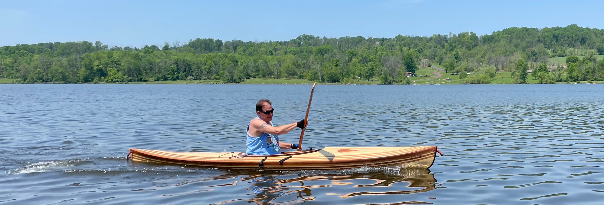
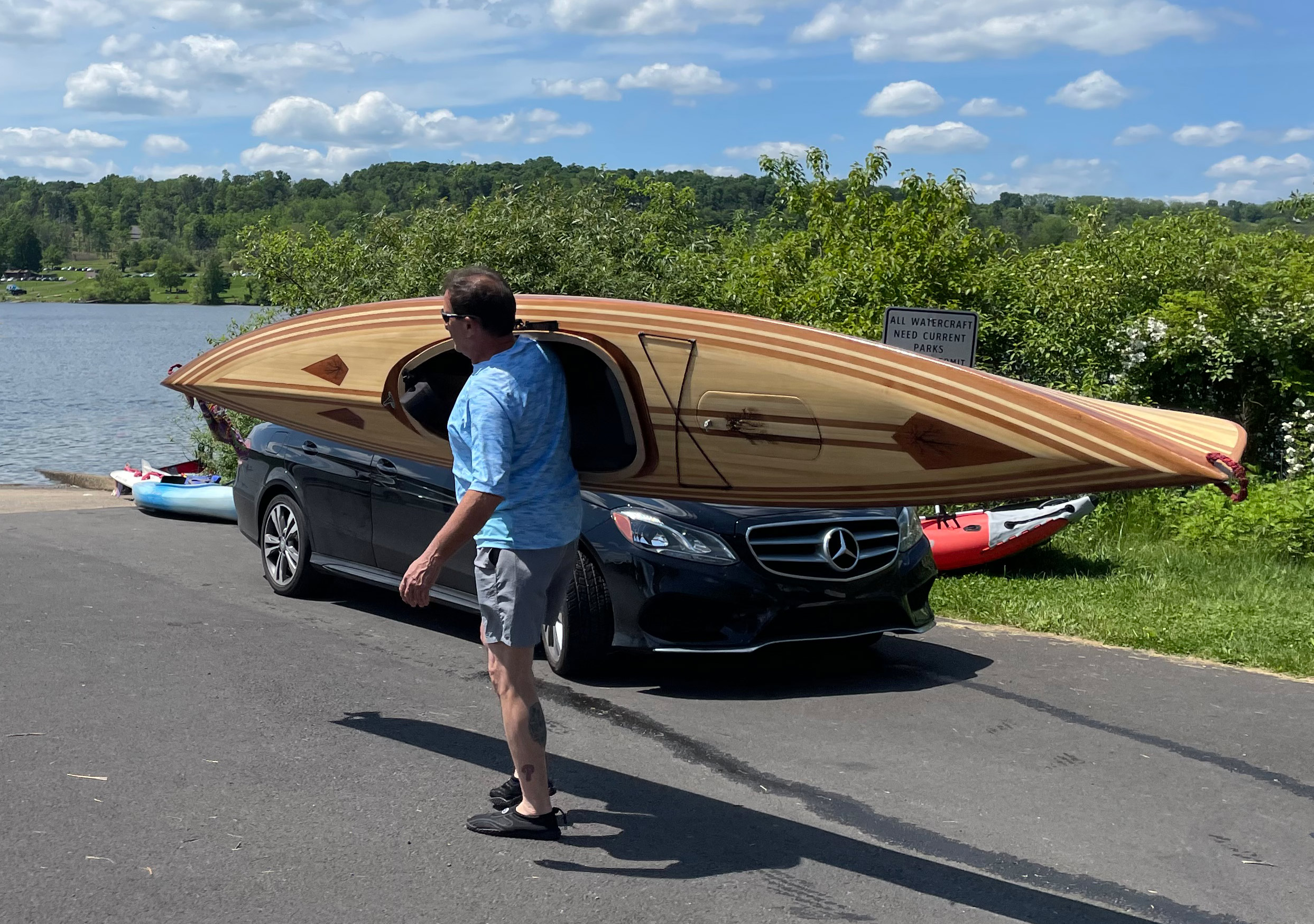 Photographs by and courtesy of the author