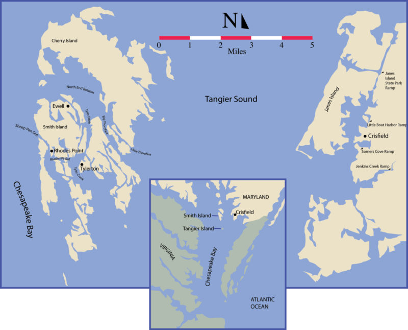
The Chesapeake Bay is full of islands, though most are only technically islands. Most are separated from the mainland by narrow creeks and marshes and connected by permanent bridges, so they don’t feel like islands. Surprisingly few are true islands at some distance from shore, and fewer still are places people call home; people have lived on Smith and Tangier islands for centuries, since the earliest Europeans sailed up the Bay.
From the end of the town dock, at the end of Main Street in Crisfield, Maryland, you can’t actually see Smith Island. You will think you can. Refraction makes the trees and houses of that place float above the horizon in a shimmering line. Sometimes it’s sharp and clear, others it’s a smudge of smoke that comes and goes as light and air change throughout the day, and still others it’s just a ripple at the waterline.
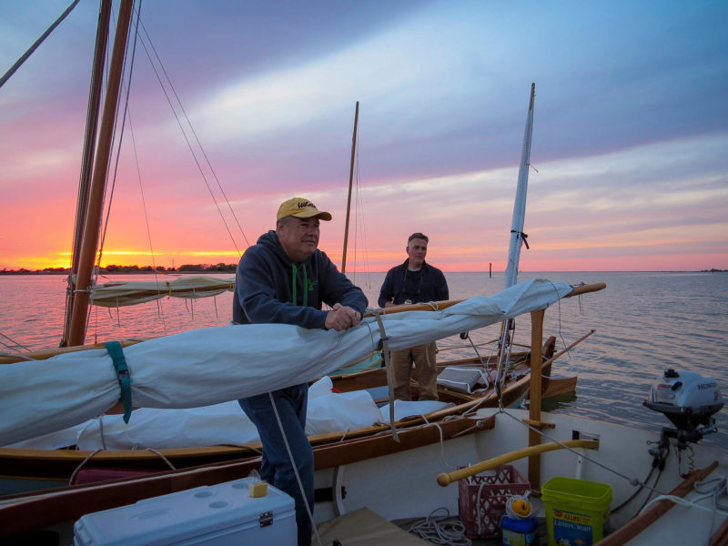
 all photos and videos by the author
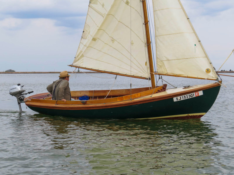
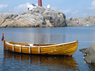
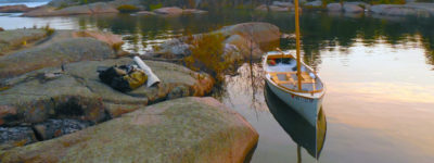
The fleet leaves Crisfield for the crossing to Smith Island.
You can see Tangier Island from Smith in this same way. The two islands are really just exposed parts of a single island mostly submerged. Six miles of shallows connect them, with water so thin you could almost wade from one to the other at low tide. The shallow flats are a garden of sea grasses, and that garden makes this one of the best places on earth for blue crabs. From the southern end of Smith, telephone poles march resolutely across the flats and over the horizon on the way to Tangier, linking the two. When a curtain of rain or fog closes off the distance, the poles are a reminder to each island that the other is still there.
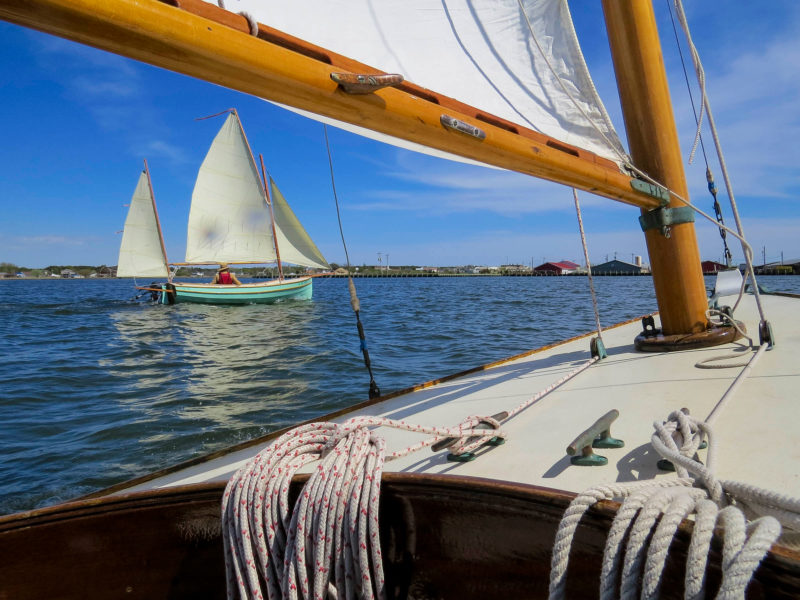
We tack down and out the narrow canal that separates Janes Island from the Maryland mainland, come about leaving the mouth of Crisfield’s harbor, and then fan out across Tangier Sound. By mid-afternoon, five boats are scattered across the sound headed for Smith Island—two Joel White Marsh Cats, an Iain Oughtred Sooty Tern, a Howard Haven 12 ½, and a John Welsford Navigator, all hand-made, most of them owner built.
Tangier Sound has a bad reputation among the locals. With a long north–south fetch, conditions can change quickly. There’s a deep, steep-sided trough down the middle of it over an ancient and submerged Nanticoke River bed, and shoals line both of its sides. Rolling waves build up coming down the trough, then pitch fits when they collide with the shallows. We’ve set aside five days for the trip to account for bad weather. In the Middle Atlantic region, weather systems tend to blow themselves out in 24 to 48 hours. With a big enough window between them, a couple of days’ good sailing is almost guaranteed.
Today is an easy sail across, with a light southerly breeze at slack tide, though a storm front is expected sometime tomorrow. Heading due west, we follow smudges of the island that come and go; when in doubt, we aim for buoys, lights, and day markers. Halfway across, the wind fades and the sea turns a slick, burnished brass in the afternoon light. The wind returns, light but steady, and holds for the rest of the crossing, and all five boats converge again near the island.
Spotting the mouth of the main channel, known as the Big Thorofare, is a challenge. Land here is so low there’s little difference between what is water and what is not. And Smith isn’t a single big island, it’s a spatter of small ones, hundreds of them. It’s an archipelago of marshes and winding creeks that disappear and reappear with tides. Salt grass and shoals stretch out for miles north and south.
The low-lying land of Smith Island keeps it well hidden from the mainland some five miles away.
Once in Big Thorofare the water is wide, though the channel is not; depths marked on charts are overly optimistic. A rising tide helps here. With few landmarks tall enough to rise above the grass, straying from a marked course could easily get a stranger lost. All the creeks look the same so it’s good to steer by GPS or compass, and to have a shallow-draft boat.
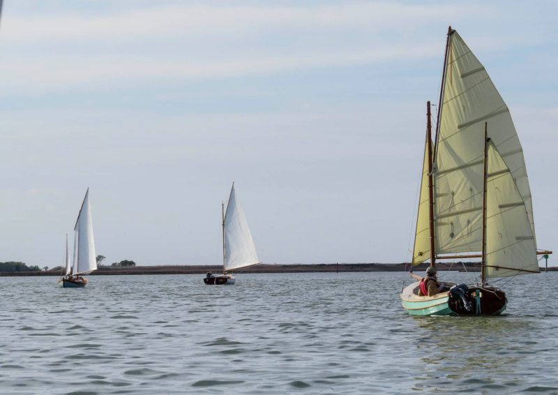
The two Marsh Cats—Kevin MacDonald’s LITTLE T and Pete Peter’s OBIDAIAH— are in their natural element here. They’re wide, flat-bottomed, stable, and heavy and stable, with tall rigs that reach above the grass to catch the wind. The Sooty Tern—Eddie Breeden’s UNA— is graceful and nimble as a dancer, and glides along effortlessly. Kevin Brennan’s Navigator SLIP JIG is a biggish small boat; though it weighs only 300 lbs empty, it may be the most versatile in the fleet. Mike Wick’s JACKAROO is a Haven 12 ½ weighing over 1,409 lbs. With a deep keel and a fine bow, she’s the best suited of all for a rough crossing in steep chop, but here must pick her way carefully: though drawing only 1½′ with the board up, half the water within the island is less than that at low tide.
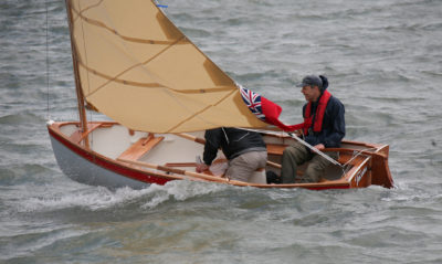
UNA and LITTLE T take advantage of the breeze in the Big Thorofare.
Once we’re in the main channel, the course bends to the northwest past the wreck of an old fish house hard aground at the edge of the marsh grass. Houses on the island are built like boats, by boatbuilders, and often meet the same end; undone by seas and storms, they’re left to crumble where they fall. Two miles in, the water opens up in a broad shallow basin. This is North End Bottom, a big beating heart at the center of the island, a mile wide, that pulses with tides and boat traffic.
On Smith Island there are three villages clinging to hummocks of land, separated from each other by marsh and water. Ewell and Rhodes Point are a mile and half apart. They are connected by a single-lane road that wobbles between them, when the water isn’t high, built on a bed of mud dug from the marsh. Tylerton is set off on its own to the south, accessible only by boat. All three are within sight of each other, and this helps diminish the sense of isolation.
At day’s end, the fleet rafts up for dinner at North End Bottom.
At North End Bottom we turn south toward Tylerton, tacking into a gentle current, sailing now for the pure pleasure of it. The light and the wind are fading quickly; we cross tacks in close quarters along the marsh until we run out of both. We anchor at the main intersection of North End Bottom, Tyler Ditch, and Big Thorofare, well outside traffic lanes, in the lee of a spoil heap covered with grass and seabirds.
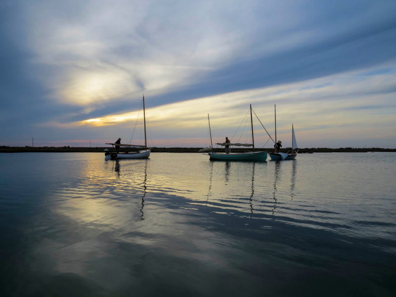
LITTLE T, SLIP JIG, and UNA sort themselves out for spending the night at anchor in the lee of a ridge of dredge spoil.
This long hill of sand, dredged from the channels and piled high, is undoubtedly the highest point of land on the island, and good protection from the wind. The sun goes down and lights of the three villages twinkle on. It’s a beautiful night, with little to compete with stars overhead. This far from civilization, surrounded by shoals, there’s no disturbance from speedboats or commercial shipping wakes. Watermen go to bed early, so it’s quiet here. Laughing gulls and oystercatchers call all night; in the morning, a loon.
Waterways are the real roads on Smith Island. Not only do you reach the island by boat, but you must also travel within it by boat, as well. Laced with creeks, canals, guts, and ditches that intertwine from one end the other, these equate to busy avenues and side streets on the mainland. Names like Big Thorofare and Little Thorofare make the analogy obvious. Before dawn the watermen rumble out in big diesel-powered deadrises to tend their crab pots. A small private ferry comes in with mail, supplies, and some passengers.
After coffee, we up anchor one by one and head down Tyler Ditch, an inelegant name for such a pretty place. Tylerton lies at another big water intersection. To port is the working harbor; to starboard Tyler Creek, the main avenue that leads south to the crabbing flats, and beyond that to Tangier. Everything—houses, churches, a general store—is built a few feet back from high water, or over it. Crab shacks, where peeler crabs are tended until they shed their shells, extend out over the water on spindly poles. Boys here learn to row before they can ride a bike. Young girls trade dreams of horses for outboard skiffs that gallop through pastures of cordgrass and rushes.
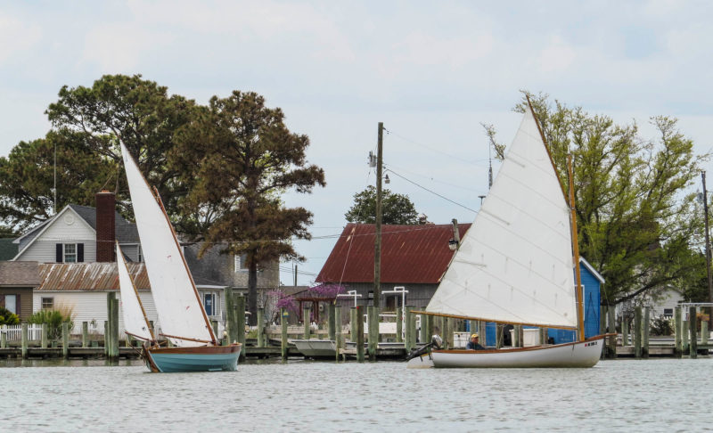
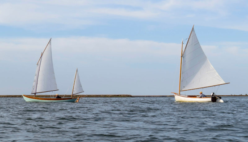
UNA and LITTLE T tack up “main street” past Tylerton.
Barriers of water make distances more pronounced. Though related by history and a common ancestry going back centuries, each village on Smith Island has a unique character and residents identify strongly with the one they are from. Each has its own Methodist church, though they share a minister. Tylerton is detached from the others, and perhaps the most independent and self-contained, an island unto itself. Ewell is the largest, almost a town, and has done the most to welcome visitors with a ferry landing, some restaurants, and places to stay. Both Tylerton and Ewell are compact and cohesive. You could lift them up and set them down anywhere, and they would still hold together.
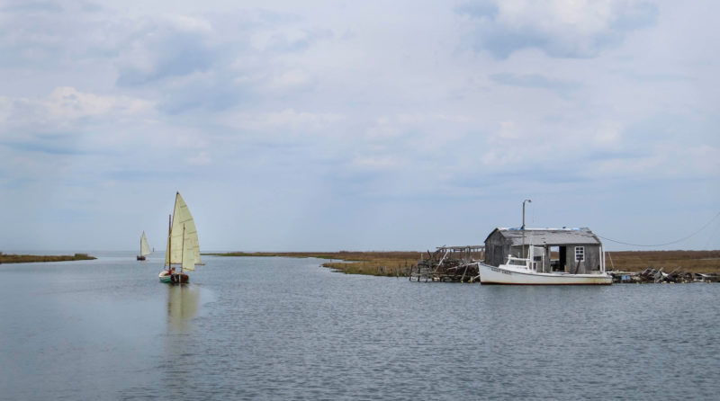
JACKAROO and SLIP JIG leave Sheep Pen Gut, headed for Ewell. The deadrise next to the shack is typical of the Smith Island workboats.
The village of Rhodes Point is on the west side of Smith. The smallest of the three, it looks worried. We reach it heading west from Tylerton into Rhodes Point Gut. At the bend we turn north into Sheep Pen Gut and coast downwind in light air, in a thin piece of water little more than a ditch that serves as Main Street to the village. Strung out in a long line, the houses face the gut, and across that a low marsh. Beyond the marsh you can see the broad waters of Chesapeake Bay. It feels exposed and tenuous here, like the gut is a moat and the marsh a door mat between the village and an ill-tempered landlord. Some houses have been lovingly maintained, shining with fresh paint. Others are in dire disrepair.
We pass a working boatyard, surprisingly large for such a small place. Watermen patch up last year’s abuses and prepare for the soft-shell crabbing season, which opens in a few days. Further on, women and kids stand on a dock with cameras and take photos as we pass. It’s so quiet we converse easily across the water. They say they’ve never seen anyone sail up their ditch. The view of our sails gliding past in the morning light clearly delights the group. There’s an appreciation for classic old boats in this place. A man hollers from a crab shack, saying we picked a good time coming through on the flood tide, which he pronounces “toyd.” “At low toyd,” he says, “’at ’ere ditch is all mud.”
JACKAROO needed the outboard to pick her way through the shallows.
A church, looking starched and pressed, more houses, crab shacks to port and starboard. Crabbing skiffs and workboats parked in slips like pickups in suburban driveways. Out the north end of Sheep Pen Gut it’s a mile jog up the Bay to the channel entrance for Ewell. A pair of long rock jetties protecting the harbor extend nearly half a mile into the Bay, like the pincers of a crab claw. They’re low, covered with water at high tide, and we almost don’t see the near one until we’re right on top of it; we veer wide at the last minute to swing around. Inside, what is marked on the chart as marsh is now open water, though shallow. We cut straight across with centerboards up, shadows of the boats visible on the sandy bottom. The Haven 12 ½ runs aground, unshipping the rudder. Mike drops sail and turns back under outboard power.

OBADIAH and SLIP JIG arrive at the canoe dock in Ewell.
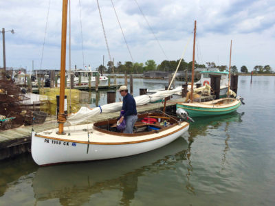
Ewell has a main street of water, too. We cruise the waterfront looking for a place to dock, and for Ruke’s, a seafood restaurant famous for crab cakes and fried soft-shell crabs. Opposite an island that appears owned by feral goats, we find a canoe and kayak ramp between workboats and crab shacks, with new docks on either side to tie up. A man says hello, says Ruke’s is closed, as are all the restaurants until the weekend when the season officially opens. He offers to walk with us to the one place we can get lunch: the post office.
The town is quiet. He leads us along narrow streets, down alleys and, when those give out, across bouncing plank catwalks that span the wet spaces between backyards and lots paved with oyster shells. The restaurants are on piers, as is a hotel and the island museum. Houses, too, are built on piles, some with front yards of brackish water.
We arrive at what is indeed a post office, and general store, and café with tables out on the docks. Inside we find the family who photographed us in Rhodes Point, happy to see us again. The shelves in the store are mostly empty, and the food not famous, but we are glad to have it, and glad to have a table looking out on the water. Workboats go by—deadrises stacked high with crab pots. A fuel barge pushed by a tiny tug makes the turn into the harbor and glides past.
Water is God on these islands: It giveth, and it taketh away. Marginal places like this are the most fertile. The water around Smith and Tangier has provided a livelihood for people since the 1600s. Crab, oysters, fish, fowl, and fur have been harvested in astounding volumes. Proximity to the fishing grounds is what made the islands a desirable place to live, but Smith Island has lost over 5 square miles to the same water over the last century, succumbing to erosion as the water rises and the land subsides. Water covers some streets here during spring tides. Holland Island, to the north, once a thriving third inhabited island like Smith and Tangier, is now completely gone. The population is eroding too, dropping by a quarter between 2000 and 2010.
Neither God nor water are ever far from minds of the people who live here. Over crab cakes and fries at the post office we chat with the man who met us at the dock. He grew up on the island, and his family have been islanders for generations. He now lives on the mainland. He says there’s never been any formal government on the island. The church always served in its stead, the place where news is shared and decisions are made collectively. He relates the story of a new minister addressing a “crime wave” that involved a stolen bicycle. That’s the extent of crime on the island, apparently. He adds that it’s very hard to use a stolen bicycle on an island that only has two roads and fewer than 300 people. There is no alcohol served anywhere on Smith or Tangier, which probably plays no small role in keeping trouble at bay.
Still, in a place where passions run high, and extended families are large and related, feuds are not unheard of. Justice can be swift and harsh. A sign on Tangier describes an incident where a young man was shot and wounded by an overzealous deputy enforcing a Sabbath prohibition against loitering. The deputy was later himself shot and killed, and the identity of the shooter, likely known to many islanders, was never revealed.
It’s getting late in the day. A text message comes through from my wife, Terri, saying a storm knocked the power out at home. Whatever did that is coming our way. We pay the tab and head back to the boats to cast off for the mainland. We hear on radio the front is approaching from the southwest, with rain and gusts expected to 30+ knots. We tie in reefs and hope to get across before conditions become unpleasant.
The tide has slipped out and the boats touch bottom several times when tacking across the channel of Big Thorofare. Short-tacking into a headwind delays us and gives the wind time to pick up. By the time we turn east we’re in full foulweather gear. We have a crossing that will take at least an hour. A lot can happen in an hour. Waves roll up the sound, it’s spitting rain, and the wind is clocking around steadily from southeast to southwest. Fortunately, we’re in the lee of Tangier and the flats, and they block the long fetch across the Bay.
We have a long, vigorous romp on a broad reach back to the mainland. Whitecaps appear from the south. The wind is not yet dangerous, but building. Those of us delayed by the bumpy exit from Smith stick together, sailing yards apart, but we lose sight of the other boats in the blowing snot. Partway across we meet friends who wisely turn back with us to Crisfield and Janes Island.
By the time the boats are secured and battened down at the docks, the wind is whipping the treetops and rain comes and goes. At a restaurant in Crisfield we watch the storm. The islands have disappeared behind sheets of rain, but we know they’re out there.![]()
Barry Long is a writer, photographer and media-arts professional from the Chesapeake Bay region, where he sails a pair of Melonseed skiffs. He keeps a blog at eyeinhand.com.
If you have an interesting story to tell about your travels in a small wooden boat, please email us a brief outline and a few photos.

Join The Conversation
We welcome your comments about this article. To include a photo with your remarks, click Choose File below the Comment box.