We had arrived at Port Townsend, Washington, a few days before the start of the 2015 Race to Alaska (R2AK) so we would have a chance to make any repairs after our sail there from Gabriola Island in British Columbia, and to watch the fleet arriving. Our 100-mile pre-race trip from Gabriola had been a success, and we felt good about our chances of winning the race—until the other boats started showing up.
 Quill Goldman
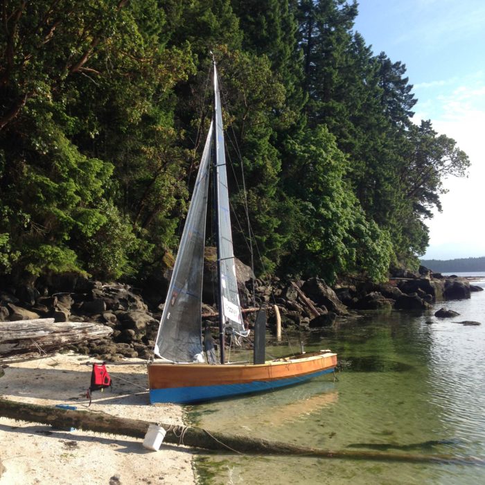
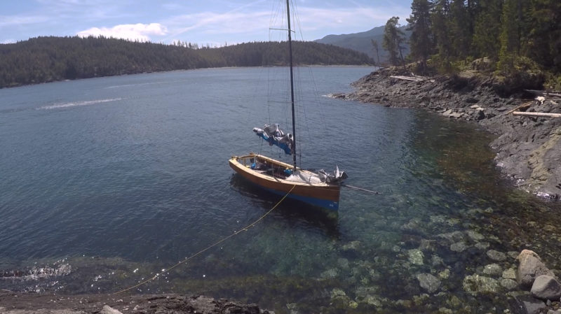
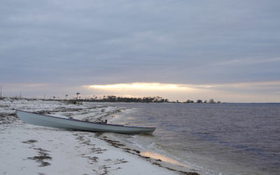
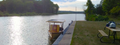
Although we launched on the scheduled day of April 12, many rig details remained unfinished. The 6-week pre-race trial we intended to do was reduced to about 6 day trips. This little beach on the northwest corner of Valdes was part of one of them.
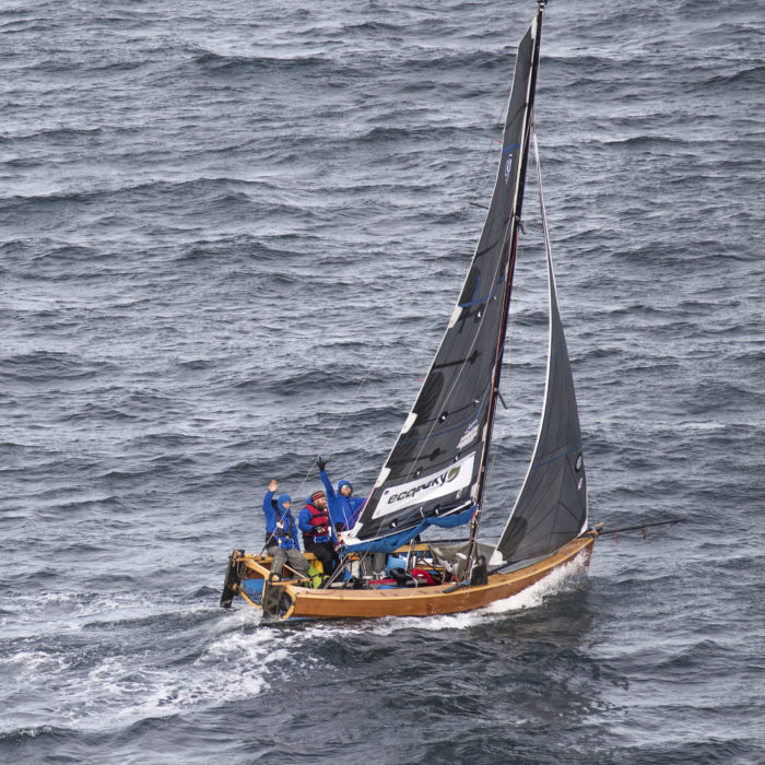
Early in the morning of June 4 we made our final preparations in the pre-dawn light, and then backed out of our slip. We were nearly cut in half by a racing shell tearing out of the darkness. Having narrowly avoided being skewered before even leaving the harbor, we hoisted our jib and sailed out past the hundreds of people lining the shores. We’d just cleared the jetty when again we were nearly broadsided, but this time by a guy on a paddleboard giving out hot oatmeal.
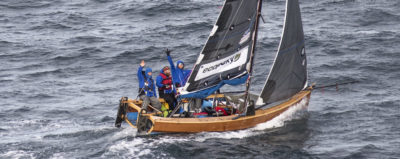
The one-minute gun went off, and we had to put our oatmeals down, raise the main, and sail back up to the line. We crossed right at the gun, ahead of the fleet of nearly 60 boats charging down on top of us. We were at the head of the pack—for a few seconds, at least, until the multihulls blew past us as if we were standing still. Catamarans, trimarans, and proas left clouds of blowing spray where their boats used to be.
The fleet was soon drawn out into two groups: the fast sailers, and the rest of us. It was blowing 15 knots out of the west, and we were happily sailing upwind at 6 knots, well behind the leaders, but upwind of many of the others.
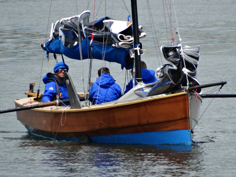 Tad Roberts
We rowed into Victoria harbor at the finish of the first leg, somewhere near the middle of the fleet. Throughout the trip, weather conditions never remained constant for very long, and switching between rowing and sailing we often found ourselves struggling into and out of our dry suits.
We noticed a small red speck growing larger on the horizon behind us. By the time we were halfway across the Strait of Juan de Fuca, Roger Mann, in a 17′ outriggered kayak, caught us, and then stayed ahead of us the whole way to the entrance to the inner harbor of Victoria, British Columbia. Just as we passed the “No Sail” marker and dropped our sails to row in, a canoe full of what appeared to be women dressed for Sunday tea came blasting around the corner behind us. By the time we figured out what we were looking at, Team Soggy Beavers, in drag, had beat us to dock.
We covered 40 miles in just over 6 hours, pretty good considering 18 teams had already dropped out.
After a three-day layover, the race to Ketchikan, Alaska, began. The morning was sunny and windless, and when the starting horn blew, we made good time getting away and steadily rowed past other boats; by the time we cleared the harbor, there were only two ahead of us. We rowed up the inside of Discovery Island, and the catamaran FELIX tacked in toward Oak Bay. PURE AND WILD, a trimaran under main and spinnaker, soon overhauled us. We kept rowing until we saw the rest of the fleet come round the point under sail.
We raised our main, but a keelboat and a catamaran were bearing down on us under spinnakers. We shipped the oars and pulled up our big orange kite. The breeze was slowly building from 5 knots, but the big boats sailed past us as we entered Haro Strait. The Soggy Beavers, six guys in a 30′ outrigger canoe, were way ahead, making a blistering 6 knots in the calms to everyone else’s 4. Team SeaRunner, a catamaran with a crab-claw rig and pedal-powered propellers, had taken an early lead and were making for the San Juan Island side of the channel.
The breeze held and we were making about 5 knots, broad-reaching north in the bright June sunshine toward North Pender Island and closing on Team Grin in their Etchels keelboat. The chase was on until we were just drawing abeam of them, when they bore away for Active Pass, no doubt looking for wind. It was forecast to blow up overnight, and we chose to stay in the more protected waters of Trincomali Channel. With no competitors in sight, the boat sailing nicely, and the golden sun nearing the mountains of Vancouver Island, I went down for a nap.
I woke to the sound of the oars sliding through their locks; I’d been out for three or four hours. The night sky was full of stars, and the wind had gone. Dylan and I rowed between the puffs through the middle of the night while Mitch slept. Even with the light of a nearly full moon, we still managed to row into a tree with a rootball, and later had to fend off a beach with an oar when the shadows tricked our depth perception.
After gaining no ground on two tacks off Wallace Island, we took to the oars again. Mitch and Dylan traded places, and as the sky in the east glowed pink, we rowed along Galliano Island. The tracker showed that our labors of the night had gained us little. Team Boatyard Boys had spent the night in a small bay and were now only 2 hours behind us, making 3.5 knots to our 2.5.
We doubled our efforts, and soon we were at Polier Pass. The wind, forecast to blow up overnight, had never materialized, so we decided to go through the pass to look for a breeze in the open Strait of Georgia. As the flooding tide sucked us through, we struggled in the light wind to avoid a long row of short, steep, standing waves that extended out toward the mainland. A mile out the breeze filled in, but it was from the northwest and counter a northward-flowing current of the strait. Seeing a patch of flatter water about a mile wide along the shore of Valdes, we decided to short-tack up the coast. I took this opportunity to try to sleep.
About an hour later I was awakened by water coming over the gunwale. I was quickly out of bed and on the weather rail. The flatter water we’d been in had disappeared. The GPS told us there was a small channel inside the reef in front of us, so we tried to take advantage of what little protection it offered. Short-tacking close to a lee shore, we aimed the boat at the foaming pile of angry waves where the channel was supposed to be. Squeaking through with large brown rocks visible just below the surface, inches from either side, we were then able to tack away from that horrible sight.
Nearing our Gabriola Island homeport of Silva Bay, we struggled to sail up around Breakwater Island, the southernmost of the Flat Top group that would offer us protection. Pinching as hard as we could to get round the point, we were just about clear, when team Uncruise Adventures came blasting over top of us, stealing our wind. Once again we found ourselves clawing off an uncomfortably close lee shore. We aimed for the nearest sandy beach on Gabriola, and within minutes were high and dry. We were hardly ashore more than 5 minutes, when we were surrounded by a group of our hometown friends. A half dozen had been watching our track on their computers, and raced to us by water and land to see what was wrong. We told them our story, then made our way into Silva Bay to gather our wits, make some essential adjustments to our reefing system, and wait for the wind to ease. It never did.
Our check of the tracker showed that most of the other teams were also holing up. A few were just going back and forth out in the strait, moving fast but making no headway. We stayed the night, constantly checking the tracker and the weather report. The teams that had stayed out were battling 40-knot winds. The wind rattled the treetops around us, and we hoped everyone would make it through the night.
We were up early, checking everyone’s progress. The three or four boats in the front had extended their lead, while most of the boats near us had stayed put. Those who had stayed out in the strait had been punished. Team Turn Point Designs and team Pure and Wild, retired from the race and were heading back south. Team Sea Wolf, sailing in a 17′, roto-molded hydrofoil, were unable to tack into the giant waves, and unable to bear away for fear of pitchpoling. With their boat nearly awash, they were slowly being driven down on to the Fraser River delta. Shortly before dawn they radioed the Coast Guard and abandoned their vessel for the safety of the rescue cutter.
Team Boatyard Boys and team Super Friends had also come into Silva Bay. We spent the day chewing our nails, checking the marine weather, checking the tracker, driving to the windward end of the island to confirm the conditions, and hiding from people we knew in the grocery store. “What are you guys doing here? Aren’t you supposed to be doing that race?”
Late in the afternoon on the third day, the wind was still blowing 30–35 knots where we were, but all the weather stations in the area were reporting moderate winds of 20–25 knots.
The lead boat, ELSIE PIDDOCK, a 25′ trimaran, was making unimaginable progress, and their lead seemed unassailable. In a momentary lull we cast off and sailed for Sechelt. It was rough, but manageable, and we had an exciting sail across the Georgia Strait. When the last of the light disappeared from the sky, we still had a couple hours of sailing ahead to reach the nearest bay. The white wave crests were all we could see, and when we sailed into Seargent Bay at 2 a.m., we were too exhausted to anchor and instead tied up to the dock of a large, empty-looking house. Spreading our mats out on the dock, we would get up at first light to continue.
Well, we all overslept, and we were surprised to see a man and woman coming down the ramp from the house. Fearing we’d be beaten with sticks for trespassing, we were quick to answer their questions. They had heard of this race, and instead of giving us a thrashing, they invited us up for breakfast. Fortified for our journey, we set sail once again.
The wind was much lighter and we enjoyed the day, sailing across to Sabine Channel where we tacked in the sunset glow between Lasqueti and Texada islands. We pulled into a nice bay at the top of Lasqueti, unloaded our gear on shore, anchored the boat, made a fire and dinner, and turned in.
 Quill Goodman
We expected to be sailing in snow and icebergs, but over 90% of our race was in sunshine and puffy little clouds. After the three days of high winds that had kept us pinned down in Silva Bay, the 10-15 knots of breeze that took us west across the Strait of Georgia from Sergeant Bay to Lasqueti was a welcome respite.
We were up at first light and ready to go, but the ocean was about 500′ from where our boat was sitting in the mud. We tried moving the boat to the water, but the beach was so flat that even if we moved it halfway, it would only get us floating an hour or so sooner. It wasn’t worth the effort, so we resigned ourselves to watching the tide come in.
The wind was back up again, and in no time the north end of Texada was off our starboard beam. The forecast was for 25–30 knots of wind to continue through the night, so we sailed for Comox. The waves were big, but long, and we were getting used to this kind of sailing. Even still, with four reefs tied in the main and the setting sun shining through mountains of green water, we were relieved to round Goose Spit an hour or two after dark and sail into the Comox marina under the orange glow of sodium lamps. We dropped our main just inside the breakwater and soon had our beds unrolled under some trees in the park.
The wind had increased overnight, and in the morning a seafood festival was setting up not far from us in the park, and their tables and decorations were rolling across the field like a bunch of tumbleweeds.
A check of the tracker on the iPad showed us that our dreams of winning this race were over. Barely five days from the start, ELSIE PIDDOCK had pulled into Ketchikan. We were barely a hundred miles into the race, with 650 left to go. It was too windy to go sailing, so we spent the day loitering. A friend took us to his house for the night where we had dinner and slept in his yard. The next morning we were up at first light, determined to carry on. There were still a few fast boats nearby that would be fun to race against, and after all, this was a race to Alaska, dammit, and we were going all the way!
The wind was moderate, and Seymore Narrows was less than a day’s sail away. During the run along the Vancouver Island coast from Comox to Campbell River, I took a nap up in the bow, and noticed when I awoke the spare rudder was being used. One of the blades had drifted off, and no one had noticed it go.
We had missed our window to get through the Narrows on this tide, so we stopped in Campbell River. An hour later and we were back in the boat, headed for a bay close to the Narrows to wait for the next ebb to carry us through.
We found a fish farm, and thinking their floats looked more inviting than a night on the hook, we tied up to one, at the bottom of the ramp that led ashore. We went up to the little house at the top of the ramp, and knocked on the door. The guy who answered was very interested in what we were doing, let us tie up for the night, and invited us to sleep in the three spare bunkbeds. We tucked ourselves in early so we could get a predawn start to catch the ebb through the narrows.
We cast off in darkness. As we sailed off the dock, we could see team Excellent Adventure beating along about a half mile ahead. We chased them through the Narrows and up Discovery Passage into the freshening 15-knot breeze. As we rounded Chatham Point into the notorious Johnstone Strait, the scattered clouds had disappeared, the sun was out, the breeze had settled into a steady 10 knots, and by the time we passed Blind Channel at the bottom of Thurlow Island, we were certain that we were gaining on Excellent Adventure, but they suddenly veered hard to starboard, toward Knox Bay. So we sailed on, working the eddies along the shore, and doing well against the current.
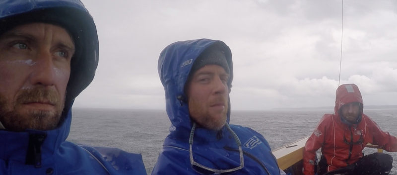
 Quill Goldman
Although funds were tight for this project, we made getting excellent dry suits a priority. I wouldn’t contemplate doing the trip without them. They served as “personal watercraft” while swimming from our anchored boat to the shore and kept us warm and dry while underway.
Mitch had gone down for a nap, and Dylan was settling in on the trapeze as we passed Kelsey Bay, when we spotted a white line on the horizon. It was approaching rapidly, so we called Mitch on deck and tied in a reef.
It hit us like a wall. The wind doubled instantly, and the lazy current became a churning frenzy. We tied in the second reef, but it was still building, and within minutes we were skipping the third reef and tying in the fourth. Still overpowered, we pinched as close as we could and let the current sweep us along past the top of Hardwicke Island. The waves were rising and falling beneath us and on top of us.
Desperate to get out of this maelstrom, we steered for the channel between two small islands, Clarence and Yorke. We had to get into the lee of Yorke’s east side, but couldn’t safely bear away, even under four reefs. Dropping the main completely, we turned and ran. There wasn’t much of a bay on the east side of Yorke, but the white beaches of Hardwicke Point looked like heaven. They faced west, into the wind, but were in Yorke’s lee. A sandy beach on a falling tide sounded like just the respite we needed.
The beach on Hardwicke was not sand, but rocks, between fist and head size. The moment we reached shore, Mitch ran up the beach and while Dylan and I struggled to hold the boat in waist-deep water, Mitch was frantically trying to peel his off dry suit to relieve a bout of explosive diarrhea. By the time he staggered out of the bushes, we were trying to haul the boat ashore. We tried stuffing logs under it to slide on, but the waves would wash them away before we could drag the boat onto them. Dylan found a large cooler on the beach. He tied the bow line to it, filled it with rocks until it was just floating, dragged it out into neck-deep water, and sank it with a final armload of rocks. This would be enough to keep the boat out of the breaking surf. After tying a pair of stern lines to logs above the high-tide mark, we were ready to light a fire and dry ourselves off.
Mitch had chosen the only flat, open spot around to do his business, so we had to make camp down the beach, underneath a low-hanging cedar. The boat would start to dry out around 6 a.m., so we went to bed early, so we could help guide it safely on the rocks in the morning as the tide went out. We lay down in the deep moss and listened to the wind rip through the big cedar branches above.
I woke up at 4 a.m. to check on the boat, and it was already high and dry. There was nothing to be done about it, so I crawled back into my bag and slept in till late. Once the sun was high in the sky, we went down to the boat to find it high-centered on a large rock. The Kevlar-sheathed bottom had held up, and a little paint would put it right again, but we had to spend the day waiting for the tide to float the boat.
 Quill Goldman
The farther north we went, the less hospitable the beaches were. Finding protected anchorages was not often a problem, but places big enough for three people and all their gear wasn’t always so easy. A beach line off the bow, and a haul back to an anchor off the stern was our most common form of mooring.
Our third, and last, handheld waterproof VHF radio had stopped working, so we were unable to listen to the marine broadcast. The wind had held steady since the previous day, at what we later learned was around 40 knots. When our boat was afloat we didn’t even bother putting up the sail, but rowed the 300′ or so from Hardwicke Island, to a small nook on the east side of Yorke. As we came in, we dropped the anchor over the stern, and paid out the rode until we could unload our gear on the beach. Once everything was ashore, I hauled the boat back out to the end of its bow line, tied off the stern, zipped up my dry suit, and swam ashore. We lit a fire, made dinner, and laid our sleeping bags down among the scrub pine along the shore.
 Quill Goldman
Although we were again shorebound by high winds for a few days on Yorke Island, the decommissioned World War II military outpost there was very interesting, and the view of windswept Johnstone Strait couldn’t be beat.
The wind had eased some overnight and we were eager to go, but continuing on without a VHF was a risk we weren’t willing to take. While I was washing the breakfast dishes, a sailboat motored close by; I flagged it down and a man got aboard a dinghy and came to help us. I asked if he had a spare handheld VHF he’d sell. He didn’t, but he gave us the phone number of a guy, who had the number of another guy, who referred us to a store that sells VHFs to fish farmers. I had a cell phone and coverage, but none of us had a credit card, so Mitch had to call his sister in New Brunswick to get her credit-card numbers. We made the purchase; a boat working the fish farms would deliver the radio on their usual rounds.
Now all we had to do was wait. That was made easier by the fact that a weather station less than a mile away was still reporting winds of 30–40 knots. The next morning though, the wind had eased to a reasonable 10 to 15 knots, the tide was favorable, and we could see on the tracker that the other teams near us had been on the move since first light.
The call we’d been waiting for came on my phone: The boat with our new VHF was on its way. So we set off in the direction we were told we’d find the nearest fish farm. We hadn’t gone too far in the wrong direction down Sunderland Channel before the delivery-boat skipper found us. He’d been zigzagging up the channel, checking every sailboat on the way. Apparently the farm we had been directed to had been moved a couple years ago.
With this critical piece of equipment delivered, we set our sights for Port Neville, about 10 miles to the north. The old store and post office had been closed for years, but we tied up to the dock and went up to the house to see who was home. The friendly gray-haired people who lived there had company in the kitchen, but were happy to let us fill up our water jugs from their garden hose. The sun was out, but a strong flood would be against us for the next couple hours. When the current eased, we cast off once again. It was well after noon by the time we were underway in earnest, but we covered 18 miles and pulled into Boat Bay not long after dark.
Scrambling around on the bluffs with our headlamps, searching for a secure place to tie up, we came across a handful of tent platforms and a small cabin. Owned by the parks, this station on West Cracroft Island overlooked Robson Bight and monitored whales traveling the Inside Passage. The door was open, and reasoning this was park property, we let ourselves in and unrolled our mats on the bunks.
 Quill Goldman
I had big plans of documenting our trip with photos and videos, providing plenty of updates for fans and sponsors, but in reality we had a hard time keeping our batteries charged. When conditions were good enough that we could take time for the camera, there wasn’t enough action to bother filming. When things did get exiting, we were too busy sailing the boat to mess around with dead batteries and tiny digital storage chips. Fortunately I managed to capture a little of the fun we had on our way from Alert Bay to Sointula. Left to right: Quill Goldman, Mitch Burns, Dylan Davenport.
We pulled our anchor early the next morning, but the wind had died, and we spent most of the day rowing 15 miles to Alert Bay in a light drizzle. The boiling current pushed us around as we rowed through Pearse Passage, and by the time we drew close to Cormorant Island, we were pulling hard upstream in the pouring rain.
Two people riding bicycles near the shore waved at us, gesturing us to follow them along the road that paralleled the beach. Pulling for all we were worth, we inched past the moss-covered pilings that held up the remains of former fish-processing plants. Our welcoming party showed us which dock to tie to and gave us two jars of canned salmon. They were fans of the race and had followed us on the race tracker.
There was a restaurant a couple of blocks away, so we got some burgers for lunch. Our constitutions restored, we put our dry suits back on and prepared to head back out into the pouring rain. Coming out the door after us, the cook brought us a freshly baked loaf of bread.
The rain eased, a light breeze sprang up from the south, and for the first time since the start of the race, 11 days ago, we hoisted our spinnaker. For about 30 minutes. Then the breeze, about 5 knots’ worth, swung around on the nose, bringing a torrential downpour.
It was only 5 miles to Sointula on Malcolm Island, but we were relieved when we finally began rowing past all the derelict marine railways that lined the bay. Our friend Nate lived on the island, and when we tied up to the government dock he was there in his truck to meet us. He took us home, let us spread our wet gear to dry by the woodstove, cooked us a big spaghetti dinner, put up his couches for us to sleep on, and took us back down to the dock in the morning.
It turned out to be another day of light, variable headwinds, with periods of rain. Our GPS showed it was 22 miles across Queen Charlotte Strait to Blunden Harbor. Tucked behind Robinson Island, it looked to be protected from any winds.
We dropped our sails as we came to the entrance to the harbor, and rowing in, the prospects for camping ashore didn’t look good. The cedar trees and salal grew thick at the water’s edge, and the only open areas were foul with sharp, pointy rocks. The light was getting dim, and the overcast sky was heavy with the rain that would soon be falling hard and fast.
As we came around the corner of the Augustine Islands, we saw a new galvanized steel-grate dock on plastic floats. A little cabin not far down the beach was just visible through the trees. A sign at the top of the dock proclaimed the land is a native reserve of the Nak’waxda’xw. The trail to the cabin followed the shore and some recent clearing of brush along the edge of the forest revealed the remains of an old settlement.
The cabin was a 16′ by 16′ plywood box, bare inside but for a woodstove and three sleeping platforms. A plastic pipe carried water from a well on the hillside to a laundry sink on the porch; firewood was stacked under the house. The door was open. We lit a fire in the stove and made dinner, and went to sleep listening to the rain thunder down on the roof.
The next morning we packed up our stuff and tidied the cabin. We were just casting off our lines when an aluminum boat roared into the bay and coasted up to the dock. There were 10 or so people on board, half of them Nak’waxda’xw natives, half of them anthropologists. We told them what we were doing and hoped they didn’t mind that we had stayed in their cabin. They were glad it had kept us warm and dry. They were here to survey the area of the old settlement we had seen traces of in the forest and along the shoreline.
It had been a village for centuries, with plank houses and boardwalks on pilings until 1964 when the department of Indian affairs made it necessary for everyone to move to a reservation in Port Hardy. Many preferred the old life, however, and some moved back to their traditional village. The department of Indian affairs responded by throwing everybody’s stuff onto the beach, and burning the entire village to the ground.
Now, 40 years later, people still want to move back; elders want to return to the village they had grown up in. This new dock and the survey were the first steps in that direction. The man standing in front of us said his mother’s body was laid to rest in the tallest tree that grew on one of the tiny islands in the bay. We thanked them and sailed out into a sunny day and we once again set a course straight into the wind.
The race had been won for over a week, and all we knew of our closest competitors was that they had last been seen days ago. We were on an expedited cruise at this point, and the farther we sailed from Port Hardy, the farther we sailed from our last chance to quit this race. We had been sailing straight upwind under quadruple- reefed main for nearly two weeks in an open boat; many other boats had long since thrown in the towel. We could have gone home, and been pleased with having come this far. But we didn’t. The boat had held up beautifully, we knew what to expect from it, and with the pressure of competition more or less removed, we had an opportunity to take the time to explore this beautiful coast.
After beating past the Richard Islands in Millar Passage, we ducked into Shelter Bay and found a nice hole to anchor in behind some islands just off Westcott Point. Once we pulled in, we could see that the beach was sandy, and the tide falling, so we decided to let the boat go aground for the night. After a short walk through the old-growth forest to watch the sun disappear into the Pacific Ocean, we lit a driftwood fire to help keep away the mosquitoes, laid our bedrolls in the sand, and went to sleep under the bright starry sky.
The boat was floating when we woke at sunrise the next morning, so we quickly packed and pushed off. The wind was too light for sailing and a thick-but-bright fog had settled in, so we rowed for a couple hours with the open ocean swell gently lifting us on its glassy surface. Somewhere around the Storm Islands the breeze began filling in, so we held our tack toward Japan, ghosting out to sea in a circle of visibility 100 yards across.
Preceded by a deep rumble, a southbound tug with a barge-load of logs appeared out of the mist in front of us. We tacked back toward the land, when all of a sudden, 50 yards ahead, there was a white line of ocean swells breaking against the bluffs of Cape Caution. We quickly came about, looking for sea room. Eventually the fog lifted and we set a course for Table Island at the mouth of Smith Sound.
 Quill Goldman
It wasn’t absolutely necessary that we stop at the old cannery in Namu, just south of Bella Bella, but it was a point of interest, and had played a major role in the history of this part of the coast. Considered by many an environmental disaster that was abandoned by those responsible for it, the reclamation by the surrounding forest has a certain undeniable beauty to it.
We’d come about 25 miles since morning. Sailing into the channel between Table and Anne islands, we found another sandy beach on a falling tide on Anne Island, and ran ashore. Our boat was moored on the east side of the island, where the undergrowth was a little thinner under the ancient canopy overhead. We collected an armload of giant mussels and gooseneck barnacles from the west side, where the waves sucked out between the cracks in the rocks. It was the longest day of the year; we cooked our seafood feast over the campfire before settling in to watch the last of the light fade from the summer sky.
After our breakfast of cream of wheat with hippie grains and dried fruit, we set sail and headed north with fair winds and a clear sky. We took the route inside Calvert Island, and then spent most of the day close reaching up Fitzhugh Sound in 10 knots of wind. As we approached Hecate Island, it picked up to 15 knots, before dying away as we crossed Hakai Pass. We wallowed in a wicked slop with waves too big to row in yet not enough wind to sail. The chop washed in through our open transom, and washed back out again. The wind came back suddenly, shifted 90 degrees, and blew about 20 knots.
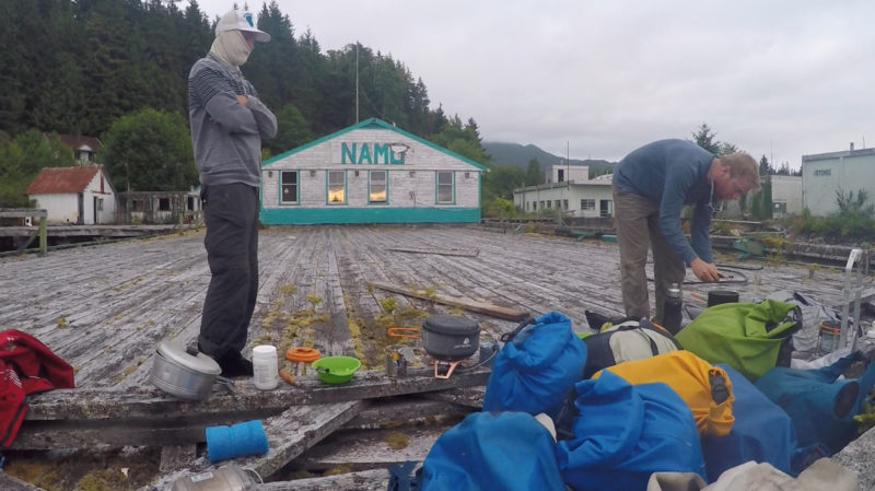 Quill Goldman
The only bear we got close enough to hear on this trip was in Namu, so we built a protective barricade to isolate us out on this pier.
We tied in our fourth reef and beat all the way to Namu, once the largest cannery on the B.C. coast. The crumbling remains of the fish plant were falling into the sea, the rows of houses swallowed up by the forest. In an old gymnasium, the maple basketball court heaved and curled, acoustic tiles sagged from the ceiling. The old roads were grown in so thick with trees that they were barely even trails. Bugs, which had slowly been growing more abundant the farther north we went, were ferocious and swarming. No amount of bug spray would keep them away, and only by burying our heads in our sleeping bags could we find any relief from their pestilential attack. So we suffocated instead.
The heat of the morning sun chased away enough of the bugs that we were able to emerge from our cocoons. We spread our sail out on the mossy planks of the pier to repair the reefing system. It had become tangled through constant frantic use. We finished up our rigging and loaded all our stuff back in the boat. We raised sail, but there wasn’t any wind, so we rowed for a few hours up Fisher Channel, until a following breeze sprang up and we were able to hoist our big orange spinnaker. We carried it all the way along Lama Pass on the approach to Bella Bella, the second of two race checkpoints.
The wind turned the corner of Denny Island with us and took us right to the Shearwater dock. We had picked up cell-phone coverage in Lama Pass, so I had called ahead to the pub and ordered a pizza and burgers; our meals would be waiting for us when we pulled in.
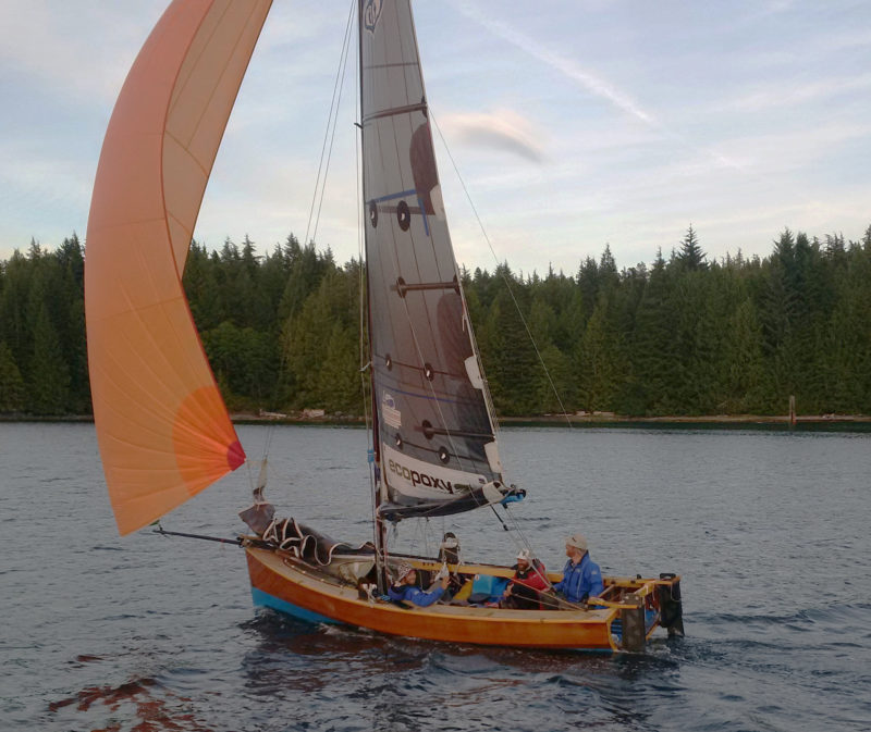 Colin Mason
We had very few opportunities to put up our spinnaker. Our friend Colin Mason came out to meet us in a friends boat as we pulled through the final checkpoint at Bella Bella.
After eating we unrolled our beds under the cedar trees on the front lawn of the fishing resort. It was good we were under the trees that night, because a heavy mist settled in, and by morning had turned into a proper drizzle. I was awakened by a dog sniffing in my ear.
We plugged our electronic devices in to charge at the laundromat while we went for bacon and eggs at the local restaurant. A few extra provisions from the grocery store, and we were ready to go. We sailed around Cypress Island, into Gunboat Pass, then west into Seaforth Channel. We were aiming to go up Laredo Sound, but first we had to cross Millbank Sound. There was a big swell running in, and the forecast was to blow up for the next couple days, so we took a more protected route to Laredo Sound between Watch and Ivory islands.
Boat Inlet, at the end of long and narrow Reid Passage, looked like the perfect place to spend the night. We had become used to sleeping ashore, but a quick survey of this shore showed us that this wasn’t going to work. The sky threatened rain, but we only had one tarp. There wasn’t a place big enough for the three of us to lie down under it, and some fresh bear scat convinced us we wouldn’t want to even if there was.
We spread the tarp out over the boom as the first heavy drops began to fall; as we settled in to make our dinner, the drops became a deluge and thinned the cloud of mosquitoes and blackflies that had grown around us. Mitch tucked himself under the foredeck for the night, but judging by his cussing, he wasn’t any better off up there. Dylan and I had the tarp over our heads, but it didn’t do much for the water that fell on the rest of the boat. It flowed down around our mats. I carefully folded my drysuit on top of my pad, then carefully laid my sleeping bag out on top of the drysuit, pulling all the loose edges of the sleeping bag underneath me to keep moisture up from wicking up from the pool my bed was floating in. I then pulled the sleeping bag over my head in an attempt to hide from the bugs, which were under our tarp, hiding from the rain.
The next morning I awoke to find I had somehow, miraculously, stayed mostly dry. Mitch, however, was soaked. It was a gray, misty morning, as we rowed out and set sail in Mathieson Channel. There was a 9’ swell running when we got to Millbank Sound, but the wind was just 10 knots, and there was a kind of queasy excitement riding those big swells under that leaden sky. The wind picked up quickly from astern, but was far too much to fly our big kite. We tied in the third and fourth reefs, then dropped the main completely, and were surfing at 9 knots under the jib alone.
When we came around the first corner of Higgins Pass, the wind eased a bit in the lee and we were able to put the smallest piece of our mainsail back up. At the first narrows, we tacked in vain against a powerful ebb current. It was a couple hours before the tide turned, so we ran back and anchored in the lee of a small island by the entrance to Higgins Lagoon. We went ashore and lit a driftwood fire to warm up to. Exhausted after the wild downwind run, we were soon asleep on the rocks by the fire.
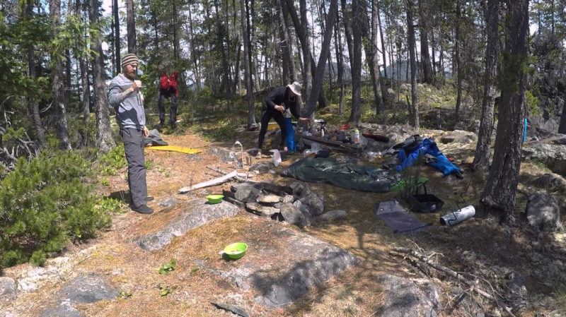 Quill Goldman
Most of our camps were characterized by an explosion of dry bags and gear. The surrounding barbed wire made this one a little different, but we assumed it was the remains of an old homestead’s cattle fence. Instead it was meant to keep out hordes of Japanese invaders that never existed.
We woke as the tide was beginning to flood. The pass wasn’t navigable at low tide, and when we got to Lohbrunner Island we chose the shorter, but narrower, southern route around. With our boards up, just a little piece of rudder in the water, and our oars ready to fend off, we ghosted through with an inch or two to spare underneath and to either side.
When we came out from behind the cluster of islands that cover the western end of the pass that runs between Price and Swindle Islands and into Laredo Sound, there was still some swell, but the wind was a fraction of what it had been in Millbank Sound.
As the light grew dimmer and we neared the southern end of Aristazabal Island, it died away, and we had to row to a little bay around the corner of Tildesley Point. The GPS screen flashed, “This accessory is not supported” and winked out forever. We still had Navionics on the iPad, but it used too much power, and we could only afford to turn it on briefly. The GPS had kept track of every tack and jibe, and although we were only half way into the 750-mile race, it had recorded that we had traveled 1,500 miles over the ground. Losing the GPS wasn’t quite as crippling as the VHF, but was felt even harder, as we used it constantly.
Aristazabal offered us a sandy beach on a falling tide. By the light of our headlamps, we rolled out our beds above the tideline between logs half buried in the sand, and went to sleep to the gentle pitter-patter of sand fleas jumping on our sleeping bags.
The boat was floating again by 9:00, so we set out under full sail and a sunny sky. The wind was light, and on the nose and we tacked up Laredo Sound. At dusk we were near a lagoon halfway up the west side of Princess Royal Island. On a rising tide we pushed our way with the oars through one of its narrow entrances, and found ourselves surrounded by jagged rocks that seemed to rise up out of the water in unpredictable places.
We found a section of shore where the sharp, pointy rocks were small enough that we could lay our beds down on them, and scavenged around for wood to build a fire. What we could find was too wet, and no amount of tinder or carving away the wet outer layers seemed to work. We blew on it until we were too exhausted to blow anymore, then, just as we were falling asleep, it caught.
We got under way shortly after daylight the next morning. The water was glassy calm, and there were humpback whales blowing and jumping all around us in the golden morning light. We drifted along, rowing only when the wind failed completely. The whales drifted off, but a couple of curious sea lions followed us.
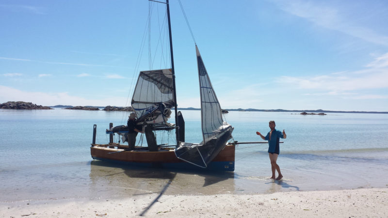 Dylan Davenport
The beaches of Campania were among our favorites of the many beautiful places we stopped. Our stay on one of its long white beaches was brief, with a quick snack and a refreshing dip while we waited for the current to ease and the breeze to build.
We rowed across Squally Channel, and up the west side of Campania Island. The sun was hot, the current running against us. We rowed through kelp and over a sandy white bottom where hundreds of flatfish shot off in all directions. We beached the boat and stretched our legs in the pristine white sand. There were wolf prints all over the beach. We found a small stream and I took off my clothes and washed the salt off them and myself.
The wind filled in, so we cut our stay short, and headed out into Nepean Sound. There was only about 7 knots of breeze, but it was a little more west than north, so we made good progress and sailed another 20 miles before we stopped in a small bay on the southwest corner of Pitt Island. We collected firewood in the failing light and camped where the edges of the forest met the scrub bush that grows along the shore. The moss was so thick we needed mats to keep from sinking into it.
At the first light of day we ate a breakfast of blueberries from the bushes surrounding our camp and filled one of our jugs from a stream nearby. As the pink morning glow crept down the mountains of Banks Island to the west, we sailed into Nepeah Sound. The wind was steady but light, and at midday, as we reached Principe Channel, the current took us backward faster than then wind could pull us forward.
We were debating whether to pull out the oars or land to wait out the tide when a couple of aluminum speedboats approached and several native fishermen pulled alongside. When we told them who we were and what we were doing, they looked at the boat, then looked doubtfully at us. They asked us if we wanted any salmon. We said sure, how much? “Oh, no charge,” they said, “we just caught 200 sockeye. How many do you want?” We didn’t think we could deal with more than two, but they gave us three anyway and wished us luck. We hit the beach to dress the fish. Giant cruise ships motored past on their way to Alaska, and we speculated on the contrast between their trip and ours.
The wind picked up enough that we could outsail the current, and before long we passed Anger Island. The sun disappeared as we crossed Petrel Channel, and behind the Cliff Islands we found a nice little rock to spend the night on. We built a fire and put the fillets of two salmon on wet cedar driftwood as close to the fire as we could without the cedar bursting into flames. While they were cooking, we ate the third salmon raw with soy sauce. The sky was especially big and starry that night, and the rock we slept on radiated the day’s heat.
We set a course down Principe Channel. The breeze was a steady 12–15 knots and we made good speed through the water, but the current was against us, so we didn’t cover much ground. A pod of humpbacks went by, making much better progress. As we sailed into Browning Entrance, our 15 knots of wind suddenly became 25 and a big swell from Hecate Strait, combining with a strong current ebbing out of Ogden Channel, made for some very tense sailing. With four reefs in, it was all we could do to sail into the lee of a small island for shelter, but when we got there, a strong current threatened to suck us into the rocks. We quickly took to the oars to move away, then had to stow them just as quickly as the current swept us back into the maelstrom. We tacked into the lee of another small rock and put ashore to catch our breath, collect our wits, and have some lunch.
There was nothing to do but go straight back out and get as much sea room as possible. We put up the main with four reefs and braced ourselves for the ride. The wind blowing in from the Hecate Strait was behind us, and when we got into Beaver Passage the confused seas turned into a steady, long, following swell. This was definitely our best speed of the trip, but we didn’t have our GPS to tell us how fast, and we were too busy hanging on to risk fishing the iPad out.
As we turned around Spicer Island, the wind veered, whistling down the mountains and out of the inlets, and we beat our way past the village of Kitkatla, the first sign of human habitation we had seen in five days. There was still an hour or so of daylight left, so we carried on to Porcher Island.
There wasn’t a good place to camp, so Mitch fought his way back into the salal until he found a spot big enough to lie down underneath it. Dylan and I made our nests on the beach. The only spots reasonable to lie down on were between big old logs at the high tide line. The spaces between them were filled with driftwood and bits of plastic flotsam, so we rearranged little sticks until only a few were poking up. We wrapped ourselves in our hot, suffocating sleeping bags against the bugs, and went to sleep with the ocean gently lapping, inches away.
At dawn our boat was hanging at the end of its beach line, bow up at a 45-degree angle in a pile of boulders. There didn’t seem to be any damage, but the boat was in too precarious a position to move, so we had to wait for the tide. It was already on its way in and eventually lifted the boat as gently from the rocks as it had set it on them.
We rowed out into a calm Ogden Channel and the breeze began to fill. By the time we got to Arthur Passage at the south end of Kennedy Island, it was raining and we were beating our way upwind in 15 knots. When we got to the top of the island, the sun came out, and the wind seemed to ease. The tide was flooding, so we decided to risk running over a sandspit the Skeena River had deposited on the top of Kennedy Island. With boards and rudders up, we charged through the breaking waves, with unknown inches of brown, muddy water beneath us and into the calmer water beyond.
We decided to take advantage of the respite to cook some spaghetti for lunch. By the time Mitch got all the stuff out, and the onions chopped, I had noticed a white line on the horizon, moving in our direction. I suggested to Mitch that he start putting everything away. He tucked some stuff away, but continued cooking. The current in Marcus Passage quickly carried us closer to the white line, and it soon showed itself to be a wall of towering waves with foaming crests. They just stood there, unmoving, while we were inexorably swept into them, as though carried down a river. We punched into the wall; green water poured over the bow, flooding the boat instantly. With 6″ of water sloshing around in the cockpit and bits of food floating everywhere, I yelled at Mitch to put the goddamn lunch away. The hatches were now underwater, so he shoved what he could up into the bow.
The current was pushing us more than our sails were, so we had little steerage and struggled to keep from being smashed into the rocks of Smith Island that were speeding by close to starboard. What waves we didn’t go through, we went over, falling off their tops, slamming into the narrow troughs beyond. We had never been so appreciative of our open transom, as most of the hundreds of gallons of green water that poured in over the bow, carried right on out the stern.
The pounding diminished as we neared open water past the Lawyer Islands, but then the river flow coming out of Inverness Passage hammered into us. We continued our fight to stay upright, until we were near the coal ports of Ridley Island, where the water flattened out, and the waning breeze turned to follow us into Prince Rupert Harbour.
As we came abeam of the big cranes at the shipping terminal, a speedboat came out to meet us. It was our friend Colin once again. We called a cab for the ride into town from the dock where we were tied up. Unfortunately the kitchen was closed at the pub, so we had a few Caesars—Canada’s much better version of the Bloody Mary. On our way back to the boat, we stopped at a 7-Eleven to buy a bunch of junk food. Back at the boat we ate our greasy “food” before unrolling our beds on the dock.
We woke up early and set sail for Venn Passage, a narrow channel between Digby Island and the Tsimpsean peninsula. Working the eddies alongshore, we crept through the kelp beds. It was sunny with about 12 knots of breeze, and soon we were reaching up Chatham Sound. The wind went light at Dundas Island, and a strong current was heading east through notorious Dixon Entrance. We played the eddies behind Holliday Island, to get well north and west before we sailed into the current. The sky was pink, and a big oily swell lifted us as we sailed across the line that marked our entry to Alaska. It was dusk as we neared Cape Fox on the mainland and completely dark 4 miles later when we passed the Tree Point lighthouse.
Mitch and Dylan wanted to go ashore for the night, but the southerly that had been forecast still hadn’t come, and I wanted to be on the water when it did. We were nearly at our goal and close to the cutoff day for completing the course: We had to reach Ketchikan before the official sweep boat could pass us and put us among the boats officially listed as “Did Not Finish.” We were in a race against the clock and the grim sweeper.
Barely ghosting along upwind, Dylan lay down to try to get some sleep. Not long after, Mitch did the same. Our solar panel wasn’t charging our iPad—we turned it on only when absolutely necessary—so I steered by the stars and the silhouettes of mountains until the clouds and the rain moved in, and then I steered by the wind coming down Revillagigedo Channel, and kept the bow pinched into the wind. Up ahead I saw a flashing light and checked the iPad to see what it was. The only light it could have been should have been astern. I realized that the wind had turned and was coming from the south, and I was now going the wrong way. I turned to sail with the wind at my back and the bow to the north.
A vessel overtook us, rumbling into the night, so I followed it, steering by its stern light until it was swallowed up by the low, wet clouds. By about 3 in the morning, traces of light were showing over the mountains to the east.
We had come about 10 miles in the dark, and were in the middle of Revillagigedo Channel off Foggy Bay as the southerly began to fill in with the coming dawn. Mitch and I hoisted the big orange kite. We set a course for Mary Island, and broad-reached through narrow, rocky Danger Pass into Felice Strait.
We made great time under spinnaker with humpback whales blowing and splashing all around us. When we rounded Ham Island, back into Revillagigedo Channel, we fell into a lee, where we wallowed for a bit, until about Bold Island, where it picked up again, but on the nose. We made our final approach with Mitch on the helm, until he had to answer the call of nature and nearly capsized the boat while trying to steer with his knee and look over his shoulder to hold his course.
 Nick Reid
Our bid for the cash prize may have been cut short early on, but we spent more time on the course and saw more of the coast than most of the other teams. Of the six boats built specifically for the first edition of the R2AK, two never made the starting line, and three never made the finish. While 28 boats set out from Victoria, only 15 made it to Ketchikan. It may sound like something your mom would tell you after a challenging day, but I think we really were the “Final Winners.”
A boat with some race staff came to see what was taking us so long, and make sure we knew where we were going. We did, but we weren’t sure how much room was in the harbor, so we dropped our mainsail before entering the basin. We pulled up to the dock at 2 pm on July 2, 25 days from Victoria. The race organizers came through on their promise of a cold beer and a warm bed. We were the 15th and final boat to finish. We had been beaten by a 60-year-old guy in a kayak, and yet we hardly tasted the irony of our title, “The Final Winners.” We had made it in one piece. All the way to Ketchikan.![]()
Quill Goldman grew up on British Colombia’s Discovery Islands, and spent most of his early years in boats, traveling from one island to another. He was interested in boats, their maintenance and construction, and enrolled in the Silva Bay Shipyard School on Gabriola Island. His boating adventures range from maxi-yacht racing in the Baltic and Mediterranean, to shipping concrete ballast from the bilges of steel ships. Quill is the owner of Barefoot Wooden Boats and has participated in all of the shipyard raids that were once popular on the North American west coast during the early years of this millennium. He is eager to see interest in these types of adventures once again take hold. You can reach him at Barefoot Wooden Boats.
Barefoot 5.8 Particulars
[table]
LOA/19′0″
LWL/19′0″
Beam/6′5″
Draft,hull/6″
[/table]
If you have an interesting story to tell about your adventures with a small wooden boat, please email us a brief outline and a few photos.
Join The Conversation
We welcome your comments about this article. To include a photo with your remarks, click Choose File below the Comment box.