If there’s one thing I’ve learned about the rowing on the Lower Columbia River, it is to go with the flow. Winters there tend to be gray, windy, cold, and wet, but when I heard that a ridge of high pressure was approaching the Pacific Northwest bringing uncommonly clear skies and mild winds at the end of first week of February, it was an opportunity I didn’t want to let pass. I’d get to row in sunshine and soft winds among the overwintering migratory birds at the Lewis and Clark National Wildlife Refuge.
The refuge consists of 20 small islands strung along 27 miles of the Columbia River and surrounded by marshes that are sometimes inundated by high tides. This reedy landscape is a winter home to 50,000 scaups, thousands more Canadian, cackling, and snow geese, trumpeter swans, pintails, teals, buffleheads, hooded and common mergansers, ruddy ducks, horned grebes, scoters, northern harriers, and peregrine falcons. For eons, countless birds have fed, rested, and nested in the refuge and along the Oregon mainland shores among the ubiquitous bald eagles and ospreys. Here the Corps of Discovery—wrote William Clark on November 26, 1805—found “Great numbers of Swan Geese Brant Ducks and Gulls in this great bend which is Crouded with low Islands covered with weeds grass &c. and overflowed every flood tide….”
For several days the weather forecast consistently called for a three- to four-day window of big sun and slow wind. Intent on catching this rare winter weather window, I put the trip together quickly. I always keep much of my gear packed in ready-to-go dry bags, so I needed only to freeze gallon jugs of water for the cooler and shop for food. I updated my smartphone with tide tables for various locations and links to real-time wind reports from the Megler-Astoria Bridge.
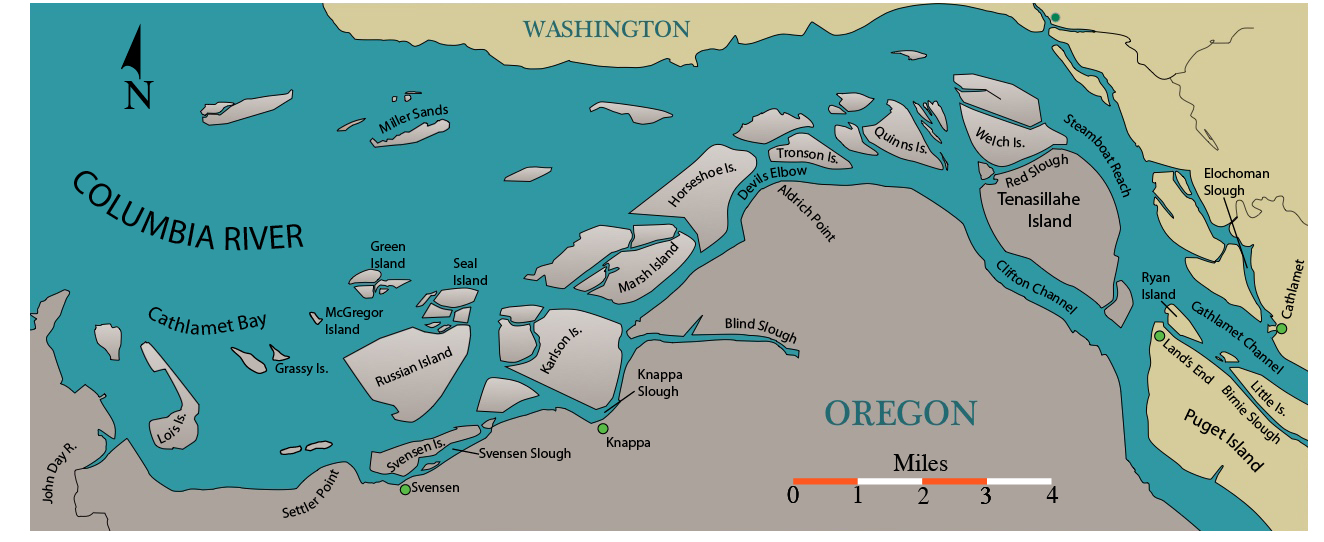
I trailered MAC, my 17′3″ light rowing dory, south on the interstate from my home in Bellingham, Washington, and reached the riverside marina in Cathlamet late Friday afternoon. I wanted to row across the Cathlamet Channel before dark and dock at Island’s End Farm on the downstream point of Puget Island. I’d met the farm’s owners, Carol and George, in 2010 on the last day of my row down the Columbia from Portland, Oregon. In the morning I’d make the crossing to Tenasillahe Island—less than a half a mile, but across the shipping lanes—and decide then whether to veer south into Clifton Channel or head north parallel the shipping channel to Red Slough and Welch Island.
 all photographs by the authror
Cathlamet is not on the shipping channel so I didn’t have to be alert for traffic as I crossed to Puget Island. As long as I paid attention to the current I could dawdle, drifting, and take photos of the scaups as they circle and fly upstream.
After getting MAC off the trailer and loaded with my gear, I rowed out of the marina and turned south on Elochoman Slough. A short 300-yard pull brought me to the Columbia River. At the buoy marking the slough’s entrance I realized that I was drifting quickly downstream and that I needed to angle 30° upstream to ferry directly across Cathlamet Channel in the ebb-strengthened current. Three-quarters of the way across the channel I was startled by a sound that seemed to be a sudden, loud waterfall. I turned quickly to see hundreds of scaups rushing into the air. Even though I was 100 yards away, my approach made them take flight. They quickly strung out and flew a wide circle around me 40′ over the water, and the muted rush of their wingbeats grew faint as they headed upstream.
I rowed looking for an opening through the small, muddy marsh islets between Little Island and Ryan Island to find my way into Birnie Slough. The dense reed canary grass and stunted red osier shrubbery blocked my view, but I finally saw a narrow watery opening. In 15 minutes I had rowed to the downstream end of Birnie Slough and there saw George and Carol walking the aluminum ramp to their dock to greet me. After joining them at their home for a Dungeness crab dinner, I headed to bed in their spare bedroom at 8 p.m. and slept soundly in the quietness of the riverside farm.
At 5 a.m. the guttural barking of sea lions in the shipping channel woke me. I knew a big smelt run was in progress, and it meant a feast for them and for the birds. Out the window, I saw a few stars above an opaque blanket of ground fog spread across the farm’s fields. It meant I wouldn’t risk crossing the shipping lanes at sunrise and could get a few more hours of sleep. I groped for my glasses in the dark, turned on my smartphone, and checked the weather forecast and the conditions at the Megler-Astoria Bridge. The wind prediction had changed overnight from just 7–12 mph easterly, to 25 mph easterly, straight down the throat of the Columbia; it was already blowing a steady 15 mph at the bridge. The flood tide working against the river flow and the strong easterly would make for rough rowing. There’d be a lot of whitecaps, and rowing along the Washington side of Tenasillahe Island would be unpleasant. At least the forecast for brilliant sun still held, and temperature would rise to an unseasonably warm 60°F. The morning’s low tide would create bit of a lee among the low-lying islands downriver, but the midafternoon high could eliminate rowing for half the day in the broader fetches among the islands. I was willing to test any fetch, but I’d do it by degrees.
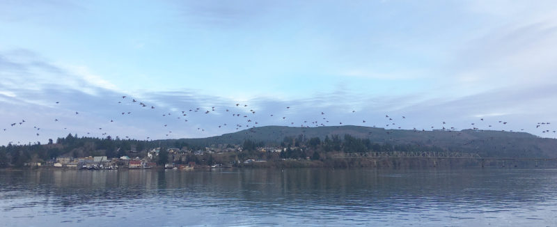
Poised to head out around the sand spit at the downstream end of Puget Island, I started the day’s rowing, as I always do when leaving land, by focusing on my surroundings, boat trim, the plan for the day and the fit of my derriere on the seat.
I ate breakfast and after I’d reorganized my gear in MAC, George came down to see me off. He pointed to a bulk carrier heading upriver toward us around the great bend and suggested I wait until it passed before I went out into the channel. I rowed around the sand spit on the downstream end of Puget Island and waited as the ship’s wake spread toward me. I casually rowed about 50′ farther out into the channel to get a better view of any traffic upstream and saw a tugboat less than a mile away coming around the corner of the Island headed in my direction. I moved back toward shore to await its passage and wake. With the shipping lanes clear, I pulled across the channel to the one-third-mile-long pile dike that guards the southern tip of Tenasillahe Island. Five seals and a sea lion followed about 30′ behind me. The long-whiskered sea lion left the chase halfway across the channel while the seals’ sleek heads would slip under to follow MAC and pop back up, quickly turning looking from side to side before resuming their focus on me.
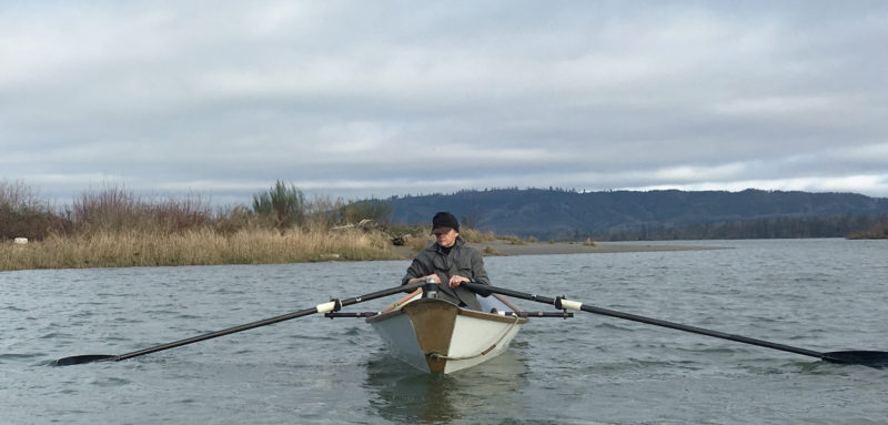
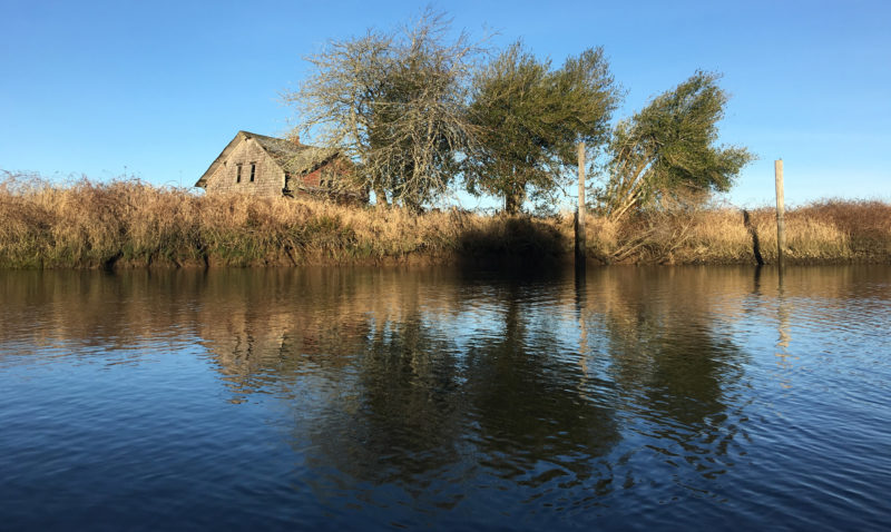
There are about 20 hunting cabins on floats permanently moored in several of the narrow sloughs between islands of the wildlife refuge. In the channel between Woody and Horseshoe Islands about ten or twelve cabins are strung like a necklace on the downstream end of Woody Island. At high tide these cabins are fully exposed to the wind. Beyond these cabins in the refuge looms Jim Crow Hill on the Washington side of the river.
I had felt cheated by the short notice of the change in the weather, and hesitant about taking a route up Clifton Channel, but I was met there with only a mild chop. As the sun burned away the clouds, I rowed along the Oregon shoreline and watched birds dabbling in the shallows of Tenasillahe a quarter mile off. My original plan was to row the serpentine route from the shipping channel along Steamboat Reach into Red Slough and past Welch Island, then weave downstream through their braided sloughs in what little protection the islands offered. But what I saw beyond Clifton Channel made me realize I’d find little lee among the islands. After the first mile, the downstream shoreline of Tenasillahe and all of Welch Island were just long lines of reeds and marsh grasses with no trees or high ground. I let go of my oars and opened Google Earth on my phone. As I ran the cursor over all the islands, I could see their average elevation was only 7′ above mean sea level. The day’s noontime high tide would be close to 10′. As I approached the downstream end of Tenasillahe it was obvious to me that camping anywhere in the refuge, even if it were allowed, would be difficult because the high tide in the wee hours of the morning would saturate any “dry” land and lift me out of any lee I might have had at low tide and expose me to the wind. I pulled easily downstream in Clifton Channel as the sun rose higher in the blue southern sky; I looked for birds, sometimes swinging MAC to travel stern-first to ease the strain on my neck from looking over my shoulder.
Without fail, every flock of scaups I came near went aloft when MAC was within 50 yards, and I again heard the sound of a waterfall as they lifted, feet furiously slapping against water to get airborne. If I were to row into the refuge I would disturb every diver, dabbler, and honker resting among the reedy islands. Being close to the birds brought me moments of quiet joy, but I couldn’t help but feel apologetic for disturbing them as they circled off to safety and protection. Losing myself in the meditative motion of rowing and listening to the sounds of the birds, the water on hull, and the wind through reeds, I left in my wake a glistening diamond-speckled path leading toward the sun. Being out on the water was my raison d’être and dissolved all of my disappointments.
An hour later, I reached the quiet lee of Aldrich Point, and the sun’s warmth filled the day and water smoothed as the tide reached high slack. The river current combined with beginning ebb and scooted me along; the thick ruby-stemmed red-osier dogwood along waters’ edge slipped quickly by. As I approached the curved channel called Devil’s Elbow, I heard a low, grumbling sound like river gravel grinding on the bottom of a shallow fast-moving stream. It was the sound of bird caucus, maybe 500 or 600 grumbling scaups about a quarter mile away. I let my oars trail and listened, turning my head side to side to gather the sound. Five minutes later I heard the unending conversations and occasional honks of snow geese hidden behind thick reeds and cattails. I held very still; MAC drifted slowly. We passed an area of sparser scrub, and some of the geese saw us through the gaps in the grass. About ten arose in indignation, honking their alarm in flight away from the danger of my little dory.
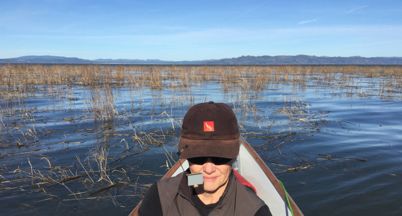
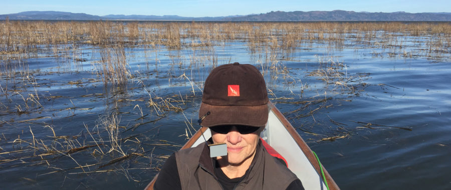
The mirror attached to the bill of my cap has caused a lot of funny remarks. Many people do not understand how I use it and I’ve even told a few gullible people that it is a GPS display so I know where I’m going. Here in Cathlamet Bay, the Washington shore seen on the horizon is 8 miles away.
Rapt with listening and seeing, I had no particular thoughts. I would occasionally remember to take my bearings and look in the bicycle mirror I had clipped to the brim of my cap. At more than one inattentive moment I had to take a quick, hard pull on an oar to avoid hitting a deadhead or getting swept into a strainer, a large, submerged tree trunk lying parallel to the water’s surface with its limbs skyward.
Much of the forested bank along the shoreline was in shadows, but I had the warmth of sun on my back. On this midwinter day, long shadows angled away from the southwestern sky and the sunlight caught a group of leaf-bare alders leaning over the water, their limbs and trunks stunningly radiant.
I needed to find a suitable camping spot either in my boat or on shore, so I pulled for the little community of Knappa, thinking I’d find a dock or relatively flat piece of land where I could put my tent or bivy sack. Out of curiosity I turned on my GPS to check my speed over ground, and with easy effort at the oars I was flying along at 5 knots. The ebbing tide was still fairly high, so I cut through the grass and reeds of a very narrow gap to Knappa Slough that would soon be impassible. I saw no public dock, and in a few minutes I was past the settlement and again surrounded by estuarine grass, reeds, and scrub that blocked my view except for the ribbon of water ahead and behind. I was quickly around the southeastern elbow of Karlson Island.
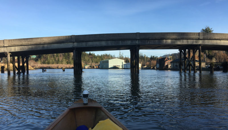
The bridge over the slough to Svensen Island doesn’t get much traffic. There are only four homesteads on the 1 ¾-mile-long island and two of them are abandoned. I saw only one person walk over the bridge while I was there.
As I rowed into the 50-yard-wide slough inside of Svensen Island, I saw a small community of floating shacks and houseboats clustered along the mainland on either side of a low concrete bridge spanning the slough. As I drifted into this very small village on the water, mallards flew directly over me in an arc toward the island. A black-and-white Australian shepherd carefully walked the length of a log float supporting a cottage no more than 20′ square with door and screen door propped open on a covered and sagging porch that served as dock. An aged, fiberglass runabout, looking about as tired as the house, was parked there. The dog seemed friendly enough, and I called out “Hello pup!” I could hear the noise of a TV in the house, and as I angled closer saw a man with a beer in hand peering out at me. I began to make out the sounds of a football game and remembered it was Superbowl Sunday. The man called out, “Nice boat!” and I replied, “Thanks! Who’s winning?” He said, “It’s only the first few minutes, and the Broncos are ahead ten-zip.” I said, “That’s a surprise, who wouldda thought?” “Yeah,” he replied, “They’ve got the defense thing down.”
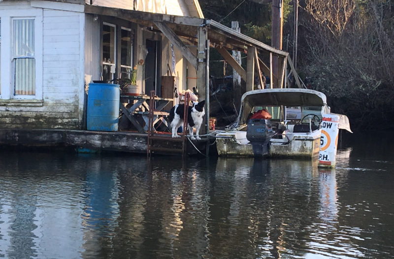
The house on Svensen Slough and the powerboat tied to it had seen better days, but I couldn’t help but envy the man who lived here as I imagined him sitting on the porch here, watching summer sunsets, beer in hand with his dog resting beside him.
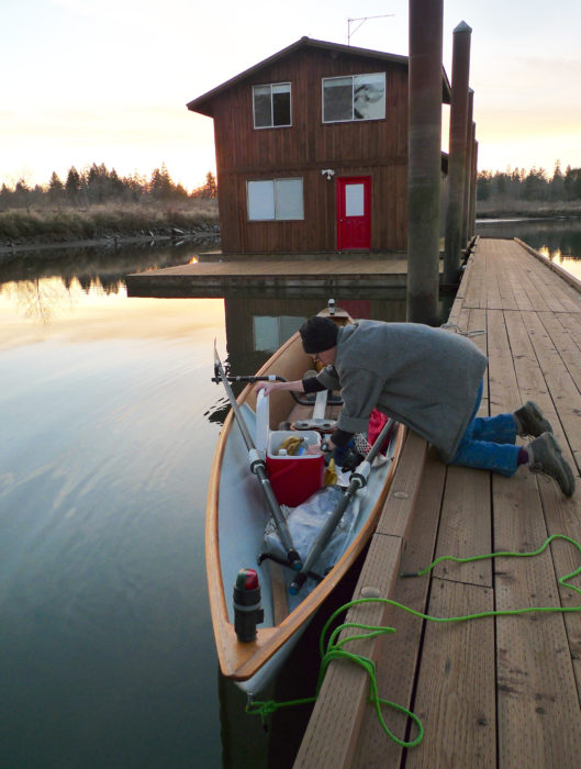
I asked if there was a dock or haulout where I could put my tent for the night, and he said, “No, there’s no ramp near here” and turned to go back to the game. I pulled on the oars, but he came quickly back outside, pointed downstream, and yelled, “Hey, the docks at the end of the slough belong to the Petersons. They won’t mind if you tie up there.” I waved, shouted “Thank you,” and turned to see a brand-new dock paralleling the shoreline with a new, as-yet-unoccupied, two-story home on it. I rowed MAC around the dock to tie her in the lee of a smaller houseboat. After securing the dory, I stretched out on the dock to rest my back and checked the wind forecast on my phone. It would blow even more tomorrow, but the wind would continue to come from the east. Here in the slough, there was only a whisper of a breeze; I listened to the geese and ducks on the island and watched a peregrine falcon soaring in a wide circle overhead. This was not the trip I had expected, but it was turning out to be better than I could have imagined.
My little 28-quart cooler is essential for my rowing travels. It’s chilled by two plastic gallon bottles of filtered water that I’ve frozen in the freezer at home. A reflective fabric cover I made to fit over the cooler adds insulation, and helps keep eggs, butter and meats at 40-45°F for four to five days. The cooler serves as a backrest when I want to stretch out while I’m on my rowing seat
I had plenty of room to put up my tent on the square wooden float, and after getting settled for a night’s stay, I bundled up as the air temperature dropped into the 40s. The sun, brilliant throughout the day, settled in the west, softening into a glow of orange, then red; I watched its last reflections on the water and listened to the music of ducks.
The two abandoned houses on Svensen Island are now is home to birds and whatever critters live on the island.
In the morning the dock was wet with heavy dew, and the inside of my tent was dripping with condensation. I tried to start up my stove, and although my Bic lighter sparked, it produced no flame. I tucked it into my armpit, and a few minutes later I had the stove roaring under my mug and in another 10 minutes, a good, oatmeal-sausage breakfast.
I set my wet tent and gear bags on the dock to dry and moved them every 10 minutes to follow a spot of sunlight coming through trees. About 9 a.m., an aluminum skiff with decoys piled on top of a bundle of reeds and camouflage netting slowly maneuvered to the dock just upstream from me. Two Labrador retrievers jumped to the dock, followed by their owner in camo waders and jacket. I spent half an hour talking to Cody Mathers, a pro fishing and hunting guide coming in from a “duck” morning. His wet, happy black Labs bumped against my legs looking for a scratch and rub. When Jody left to put the dogs in his pickup to head to Astoria, I returned to slowly packing and stowing my gear in MAC. At 11 a.m. I was on the water and pulling out of Svensen Slough toward Cathlamet Bay.
MAC immediately swung abeam to the 20-knot easterly wind blowing across the open bay. I needed to make my way downwind around Settler Point to find muted wind in the lee of the point, but it was a bit of a haul, short-stroking through 3’ chop to get to less bumpy water. I was only a couple of miles from the mouth of the John Day River where I’d end my trip. Looking over the stern as I rowed, I could see the tree-covered ridges of Washington across the watery landscape of reeds that was Seal, Green, Russian, and Marsh islands. I decided to let MAC simply drift. The wind would push us sideways to Lois Island, which sits directly across from the entrance to the John Day River. From there it would be a short half-mile pull to the ramp to haul out and head home. I looked out across the reeds and cattails toward Miller Sands, 5 miles away on the far side of the Columbia River. The chart showed there was land between me and Miller Sands—Grassy Island and McGregor Island—but I didn’t see any, only water and reeds. I let go of the oars, laid back on a dry bag, and watched and listened. MAC’s drifting startled more ducks now and then, and after an hour or so rocking side-to-side under the sun, I dozed off.
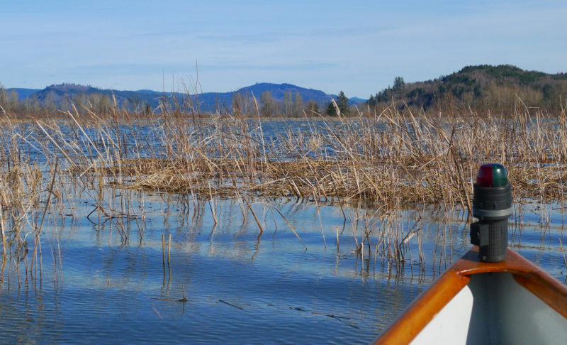
The reed growing on the western islands in the refuge is purple loosestrife, the tall, darker reed growing with the cattails and reed canary grass. It’s an invasive species that is crowding out native plants and threatening to degrade the habitat for overwintering and resident waterfowl. Efforts to control it are continual, particularly in Cathlamet Bay.
I was rudely awakened by gnats as MAC drew near Lois Island, and I took to the oars. In 20 minutes I reached the launch ramp. While I waited for my friend Jessica to come to drive me back to Cathlamet, I unloaded MAC, stacked my bags, and made a sandwich and tea.
The absence of Grassy Island and McGregor Island stayed with me. The 20 reedy islands in the Lewis and Clark Wildlife Refuge are so transformed by tides that there were some that I wouldn’t see unless I returned to row the meandering sloughs at a different turn of the tide. I’d bring MAC back, keep a keen eye on the weather, and row again with the flow and the fetch.![]()
Dale McKinnon began rowing in 2002 at the age of 57 and in 2004 rowed solo from Ketchikan, Alaska, to Bellingham, Washington. In 2005 she rowed from Ketchikan to Juneau. The Salish Sea of Washington and British Columbia is her playground. She lives in Bellingham near her grandkids, with her partner, Berns, and chocolate Lab, Thea, and builds the light dories like MAC for other rowers.
Dale describes the building and outfitting of her boat, an Oarling designed by Sam Devlin, at the end of her previous article about rowing the Columbia River.
If you have an interesting story to tell about your adventures with a small wooden boat, please email us a brief outline and a few photos.
Really nice article. Your description of the surroundings, sounds, and birds along with the pictures are very interesting and entertaining. I enjoyed it immensely.
I really enjoyed this story of your solo row on the Columbia River. I took a steamboat tour on the Columbia a few years ago and loved it. You really know how to put what you see down in words. Please write of your next row on the river.