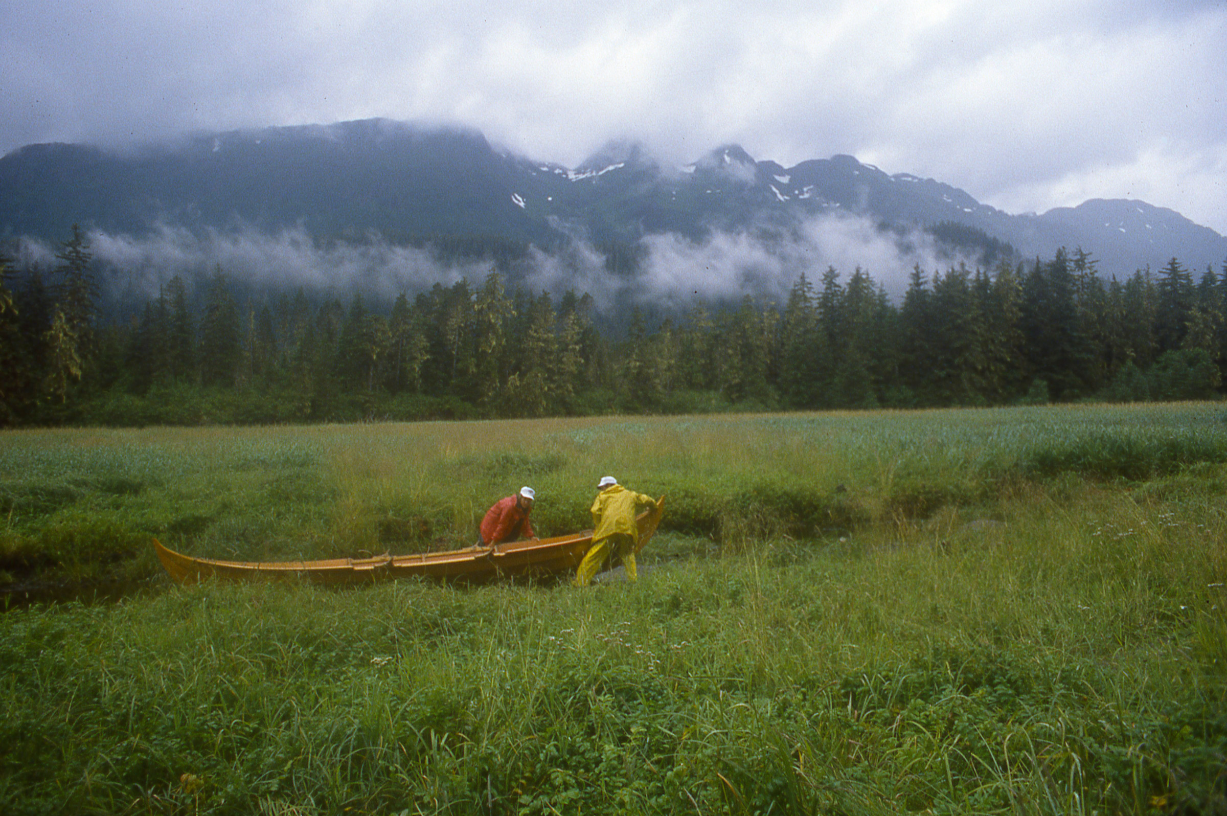
The Ugo’s laminated fabric includes a layer of foam, so the case doesn’t depend entirely on the enclosed volume for buoyancy. All of the seams are RF welded rather than sewn.
I’ve had a snap-on case for my phone and a roll-and-clip style drybag for a few other things, and both left a lot to be desired— the former’s seals failed in less than a year, and the latter turned out to be not-so-dry when I was swimming ashore from my boat at anchor. Ugo has made a superior, truly dry case for my phone, which does duty as a navigation device, text messenger, journal, emergency beacon, and social-media hub.
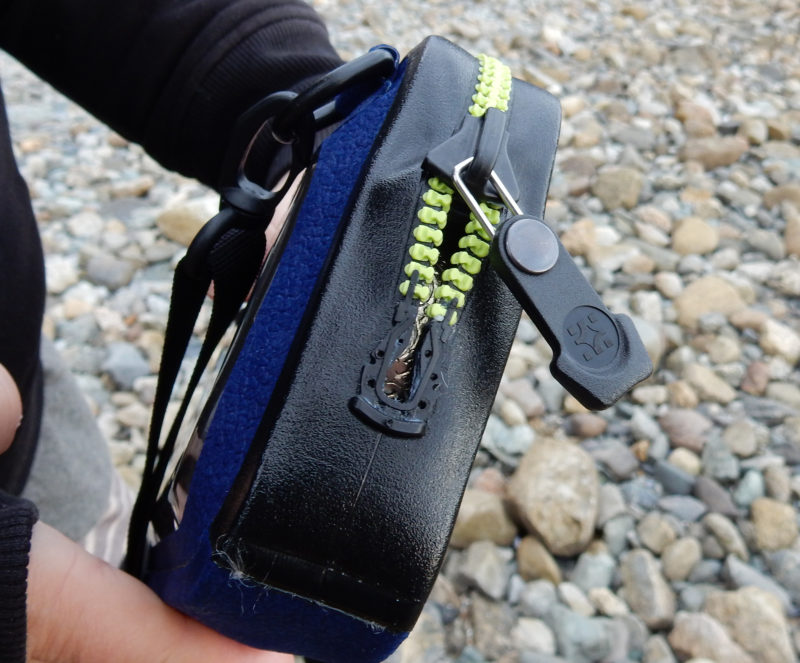
Pulled up tight against the stop, the Tizip zipper creates a waterproof seal that the manufacturer had tested to a depth of 15′. The Ugo won’t sink, so the zipper won’t be subject to water pressure in normal use.
The Ugo has a single Tizip waterproof zipper, smaller than the waterproof zippers on drysuits but equally reliable, and has an IP68 rating and was tested to be submersible to 15′ for 24 hours. There is flotation between the layers of the back panel, which will still buoy the bag with up to three phones in it, so in normal use it’s not going to be subjected to pressure at depth. My iPhone 7 itself has a rating of IP67 (submersible to 1 meter for 30 minutes), but I regard that as a measure of protection against accidental drenching and dunking, and not suited to regular exposure to water, particularly salt water.
The compartment for a smart phone has a window that allows the use of the phone’s touch screen.
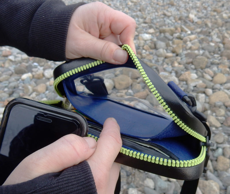
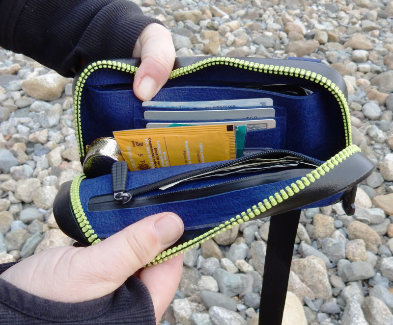
The zipper allows for a clam-shell opening for easy access to the contents. On the front of the bag there are two D-rings perfect for hanging my phone from a gunwale via carabiner with a navigation app open. Inside the Ugo, there is a pouch to hold the phone up to the clear front surface, and on the back of the divider are some credit-card-sized slots. Then there’s a main pocket area about 1″ wide, and finally there’s an inner zippered pocket that is quite slim, but suitable for cash, business cards, or anything else you’d want tamed with a zipper.
Behind the compartment for the phone there is a space to organize ID, credit cards, cash, and your stash (tea).
When I made phone calls with the phone in the Ugo, I could hear and be heard just fine. I could take video with the front camera and record sound with very little muffling, and of course, I could take selfies. Also on the plus side, I don’t have to remove my phone from its impact-resistant case to use the Ugo, which makes it more convenient to use than smaller, tight-fitting waterproof bags and cases.
The Ugo does have some downsides. The camera on the back of the phone is enclosed by the Ugo and can’t be used. My phone’s fingerprint identification function didn’t work through the Ugo window, so I had to turn that locking function off, and I had to press the home button quite hard to wake my iPhone, but those are acceptable inconveniences for the serious protection offered by the Ugo.
I often row a dinghy in rough, wet weather to get out to my boat and to take the dog ashore while I’m cruising. I also row for adventure. My Ugo provides compact flotation and impact protection for my phone, the medications I carry, and important papers. I can chuck it into the bottom of the rowboat without a worry.
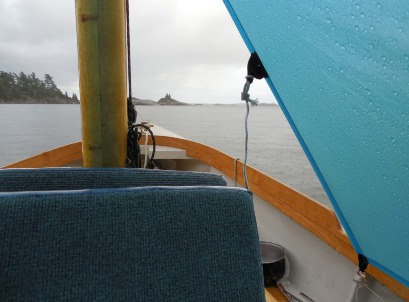
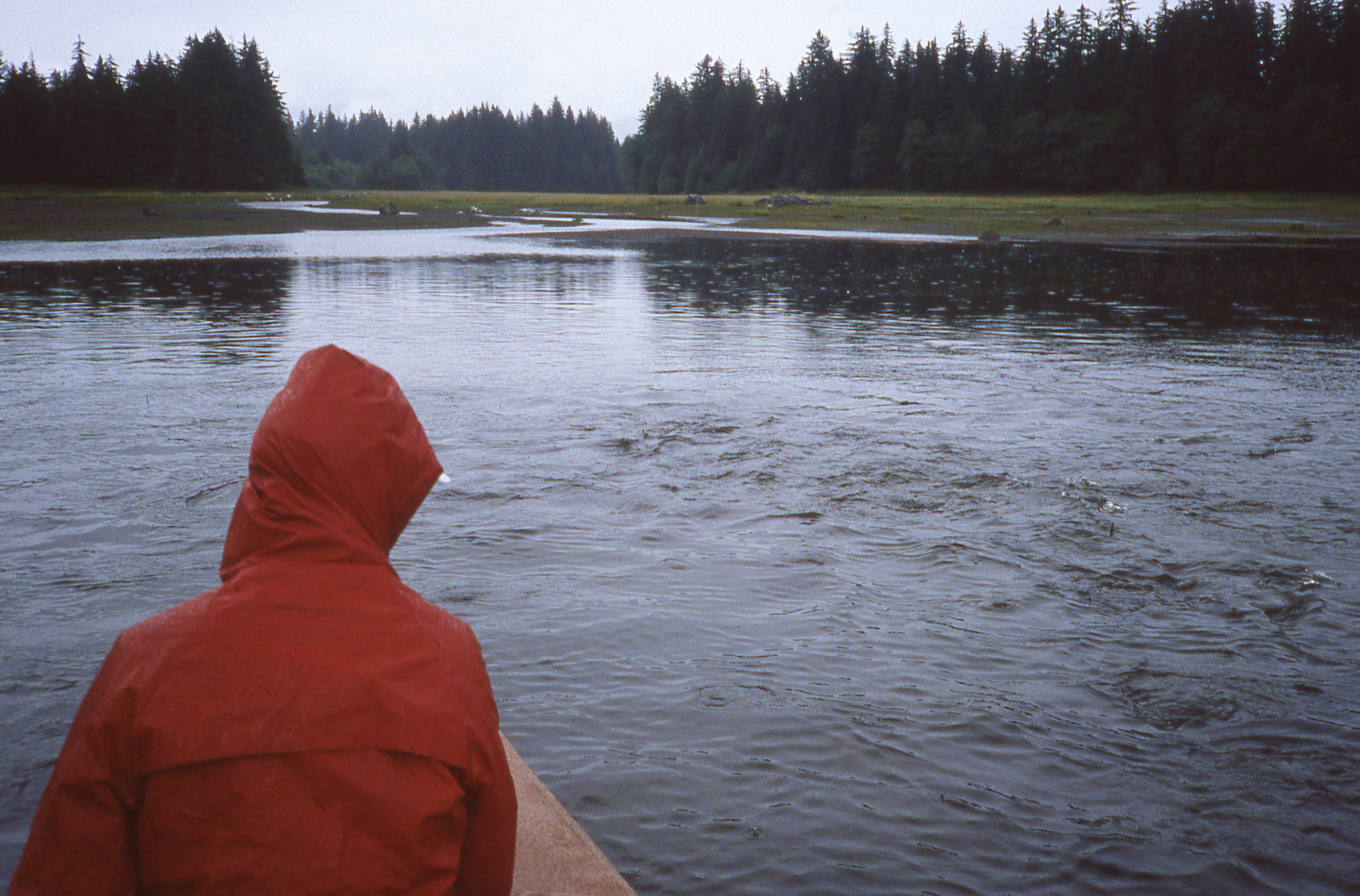
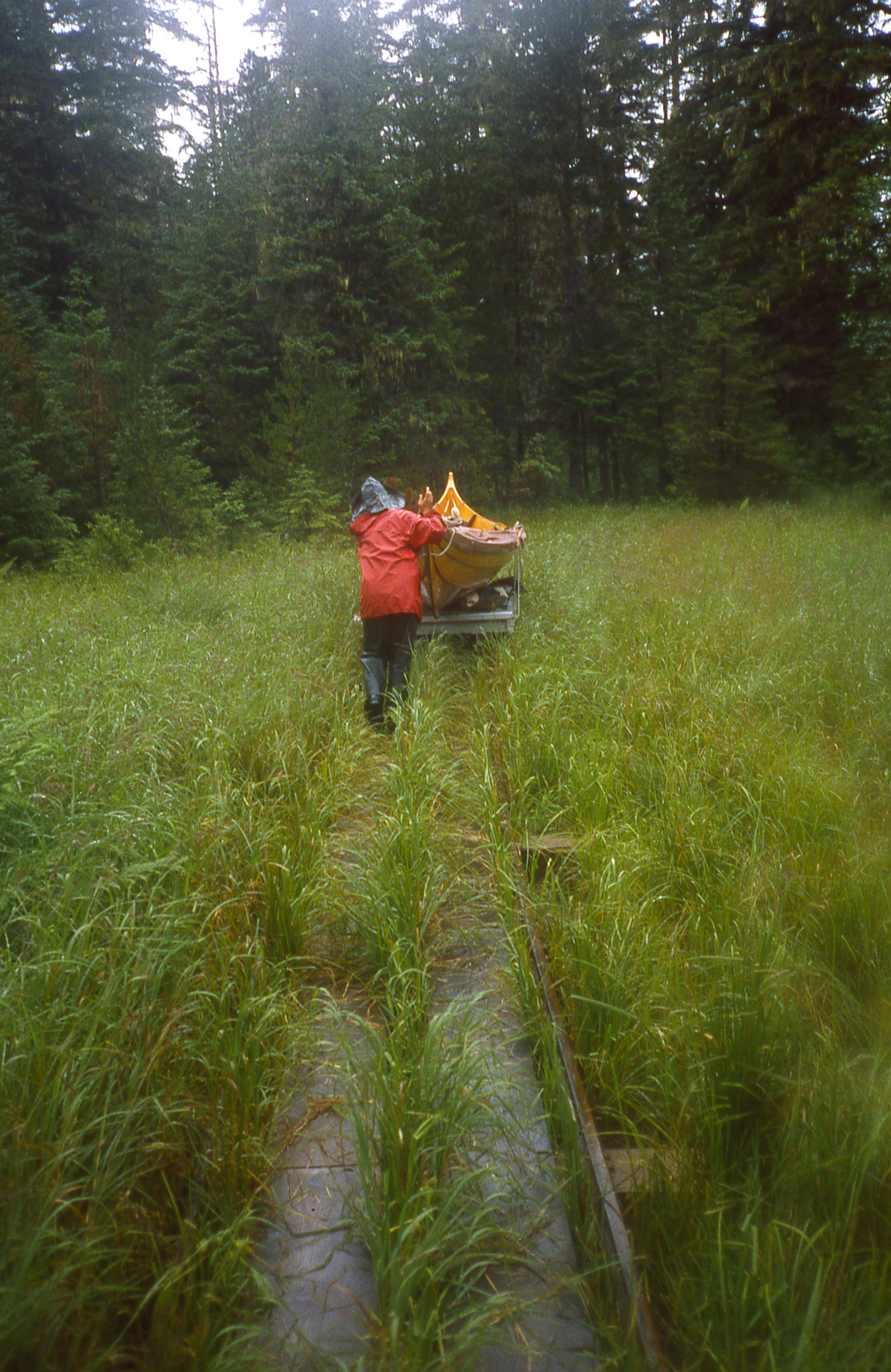
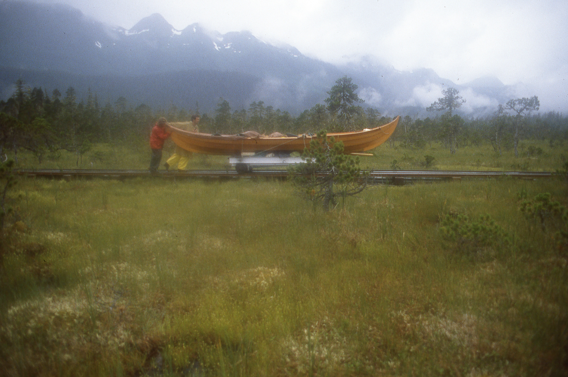
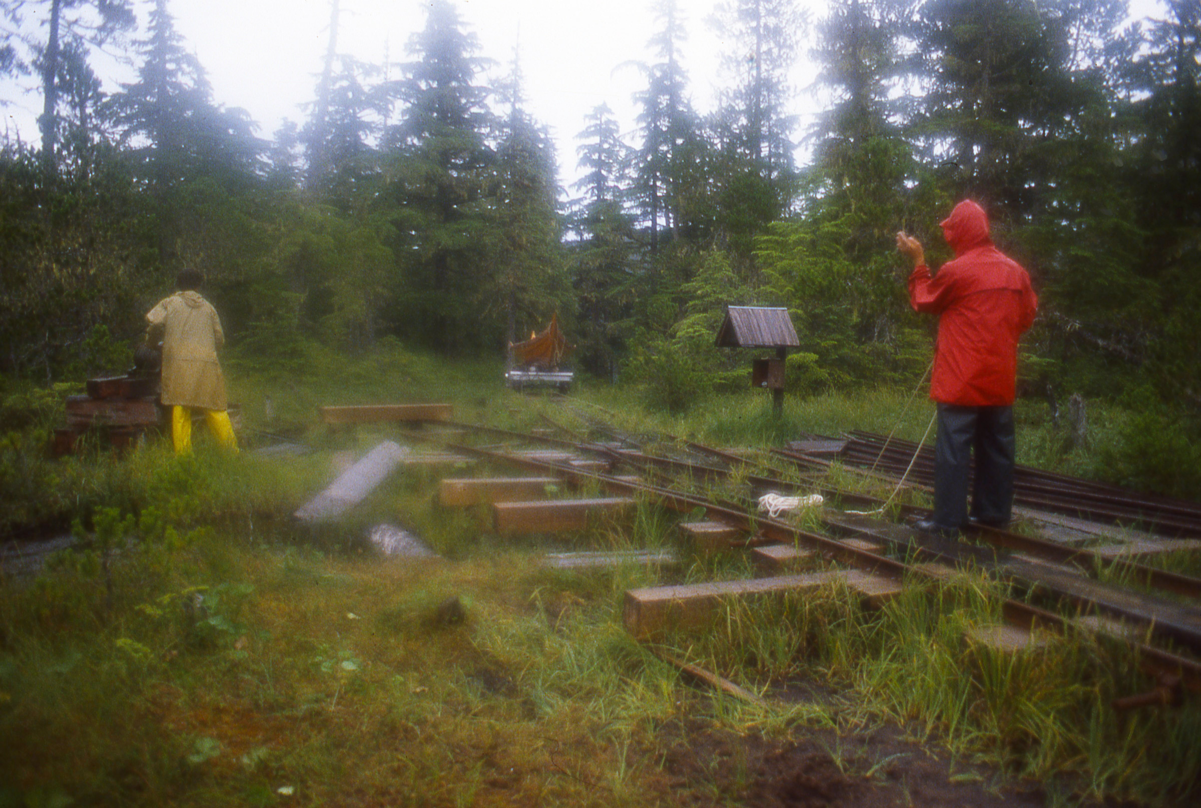
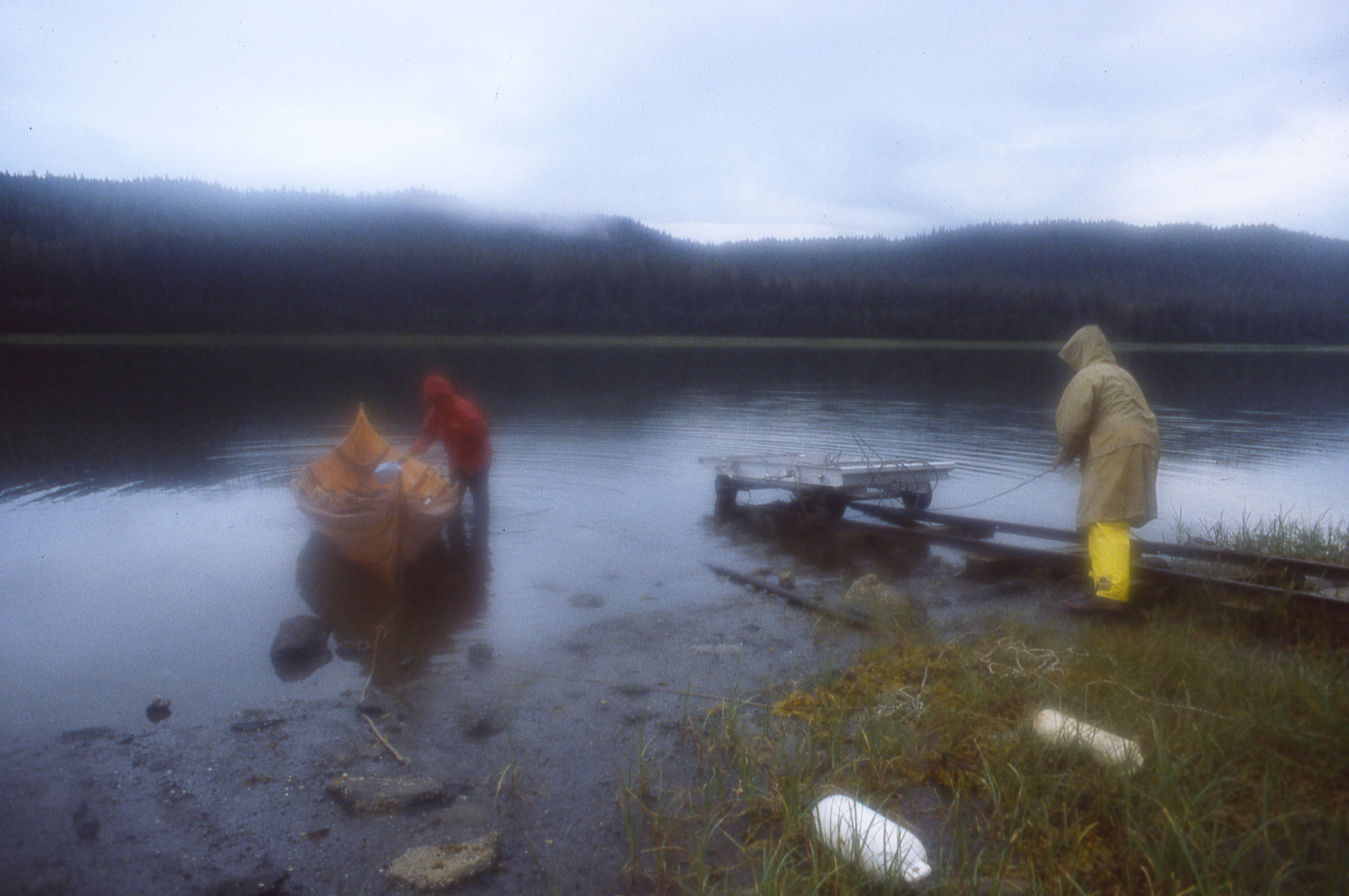
I crawled out of the boat tent as soon as the sky started growing light; a few leftover raindrops rolled off the edge of the tarp and down my back as I wriggled past. I had spent the evening huddled in my sleeping bag reading and looking at charts, shuffling gear around to keep things dry as rain pattered steadily on the tent. With a wide sleeping platform and a tent to keep me dry, my new boat was proving to be luxuriously comfortable, at least by backpacking standards, but September nights on the Great Lakes are long. After so many hours aboard, I was ready to be moving again. I climbed out into knee-deep water and waded ashore.
photographs by the author
I left my malfunctioning VHF radio in the car and returned to simpler methods of weather forecasting for this cruise—methods as simple as hearing the patter of raindrops overhead. An improvised boat tent and plenty of books helped me wait out the rain at South Benjamin Island.
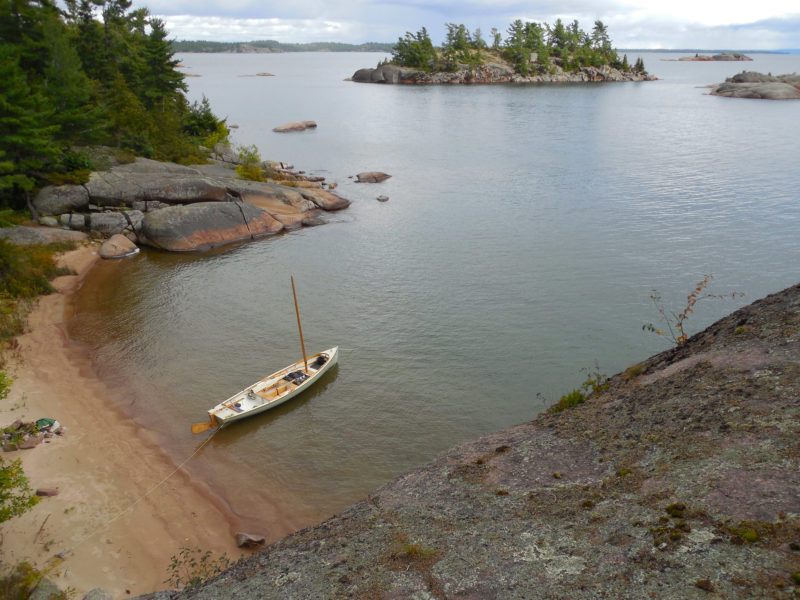
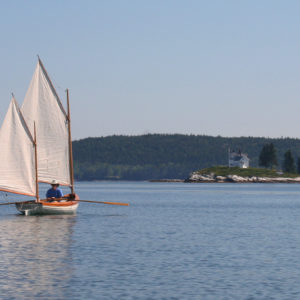
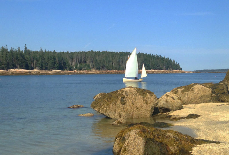
The morning was clear and cool; the sky had washed itself clean of the thick gray clouds I’d encountered on yesterday’s 10-mile passage from my launching point in Spanish, Ontario. I’d never come to the North Channel so late in the year before. The sun hung low in the sky, casting long shadows across the beach and promising shorter days. A stand of yellow-leafed birches at the edge of the beach shifted slowly in a slight breeze, and an osprey flew past with a faint flumph of wings. A dozen small islands and granite outcroppings rose from the water just offshore, and beyond them was the chain of pink rocks named the Sow and Pigs. Otherwise, nothing. There were no other boats in sight—and this at South Benjamin Island, one of the most popular cruising destinations in the North Channel.
After several hours of sailing to reach the Benjamin Islands, I was ready to leave the boat for a while. A tricky scramble through thick brush and up a steep granite slab led me to this overlook at the southern tip of South Benjamin Island.
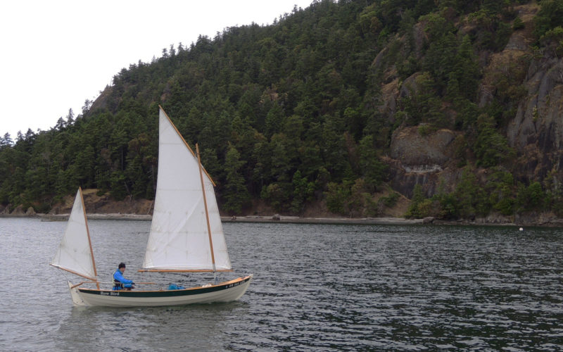
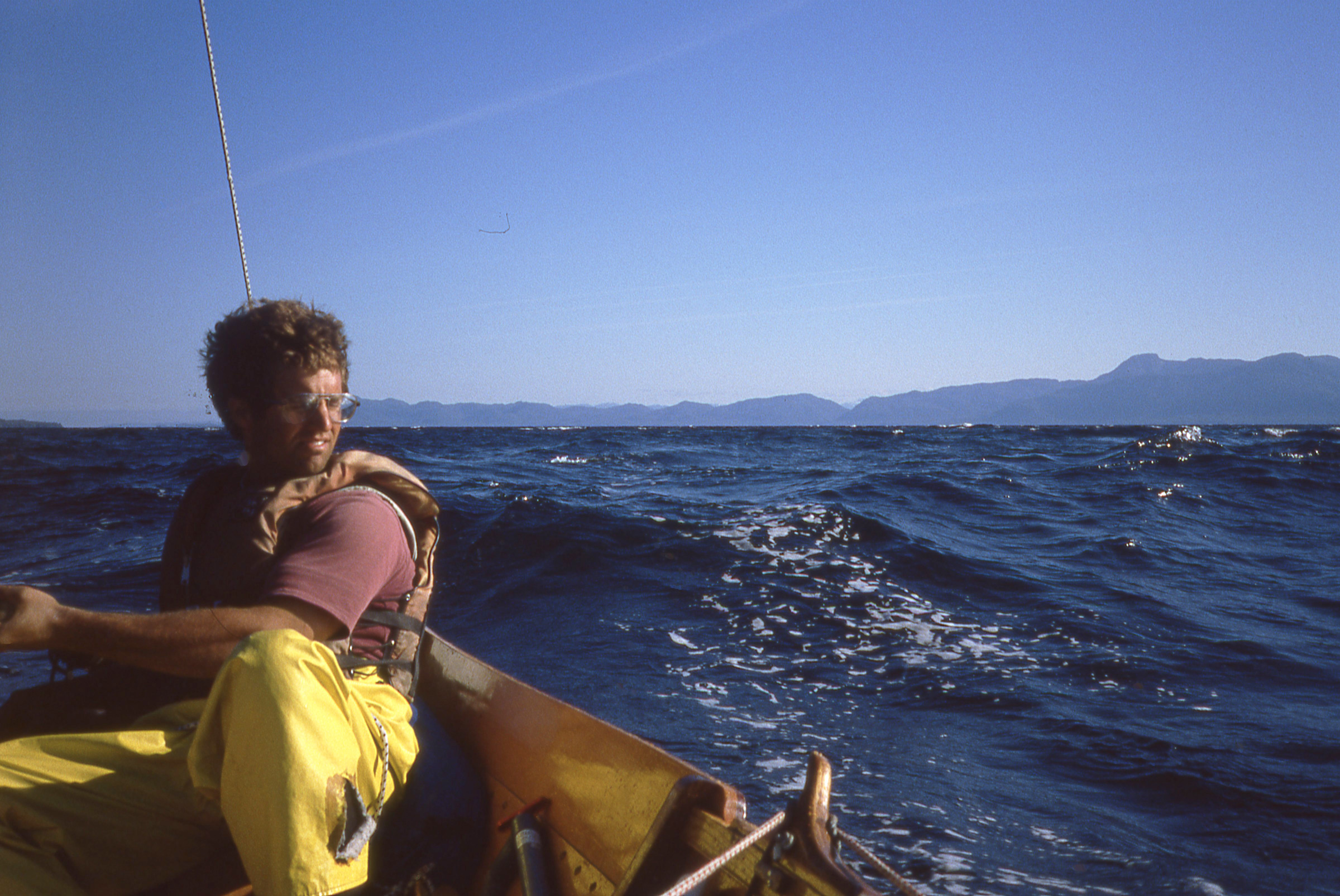
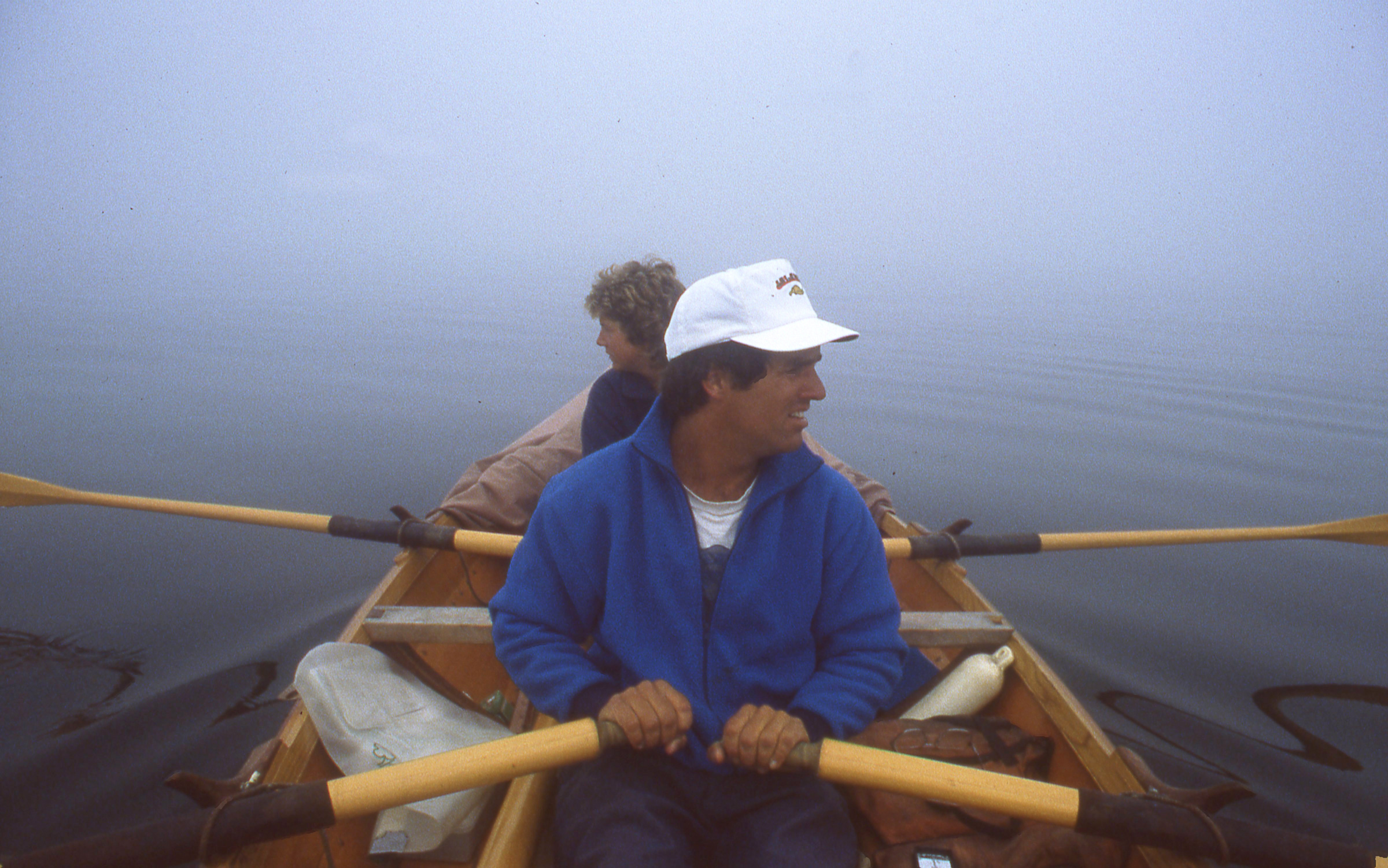
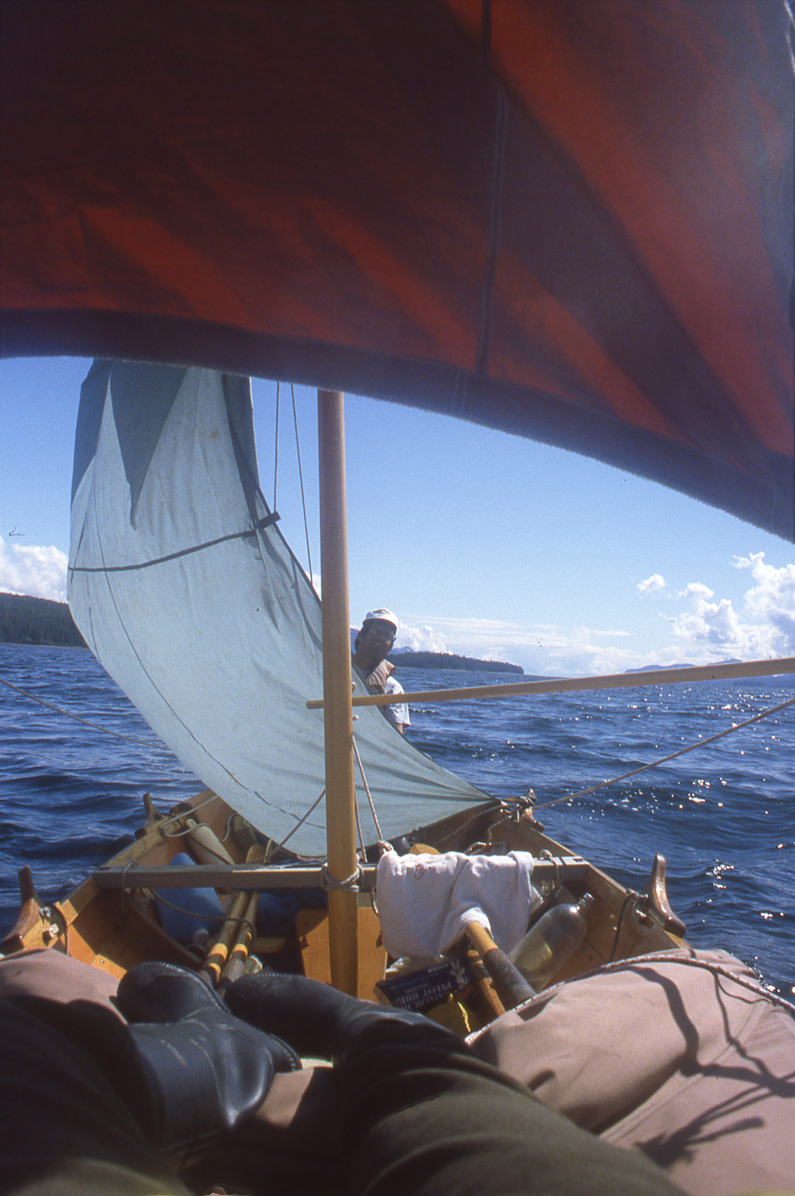
By the time I had eaten a bowl of oatmeal, stowed my gear, and had the boat ready to go, a strong northwesterly wind had come up. The open water to the east was a flurry of whitecaps, and the big pines along the shore were shifting and creaking restlessly overhead. A bit uneasy, I rowed through the rocky maze at the tip of South Benjamin and out of the lee of the island. It was windy—maybe too windy for the 20 miles I’d have to sail to reach Bay of Islands, my next planned anchorage. I’d had visions of an easy broad reach and a few pleasant days of sailing to begin with while I learned what my new boat, a Don Kurylko–designed Alaska I’d launched in June, could do. Instead I’d be starting off close-hauled on a double-reefed mainsail. Maybe triple-reefed. Well, I told myself, you can’t always wait for perfect conditions.
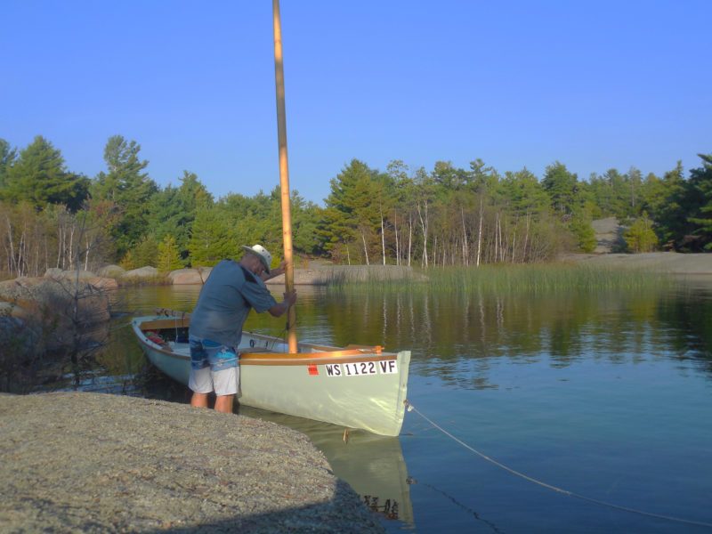
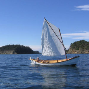
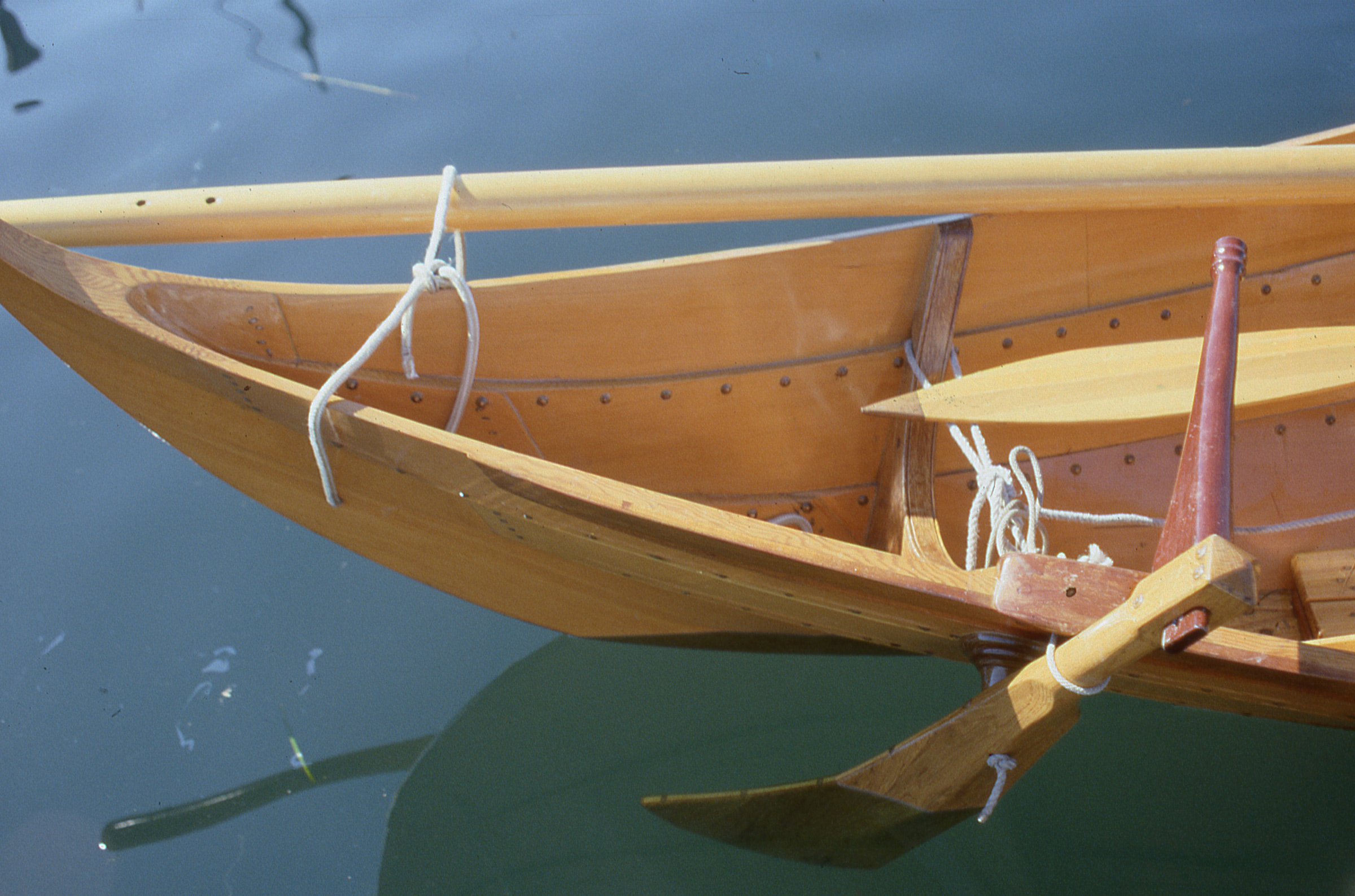
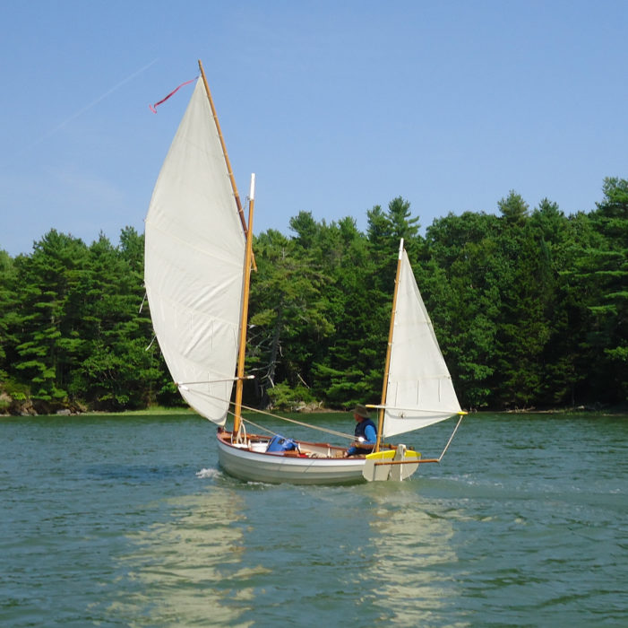
With no tides, it’s always easy to get to your boat when you need to. I replaced the mast gate shown in the Alaska plans with a simpler lift-out partner, which made stepping and unstepping the mast from shore a little simpler.
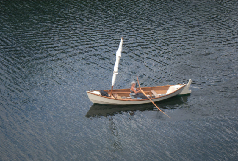
I started pulling out the sail to tie in a deep reef, but stopped a moment later, shaking my head. What was I doing? I wasn’t on any schedule other than a vague plan to sail eastward into Georgian Bay for as long as the weather was good. To set out in conditions like this, triple-reefed, suddenly struck me as asinine. Laughing out loud at my near-stupidity, I set the sail aside, then pulled out the oars. I wasn’t going to raise the sail, but that didn’t mean I had to sit around on the beach waiting for the wind to die down. I spent the morning rowing up the eastern side of the Benjamins, dodging through the wide band of rocks and shoals guarding the approaches to neighboring Fox Island. The boat, loaded heavily with cruising gear and ballast, took a half-dozen strokes to get up to speed, but kept moving through the waves with little effort and no fuss at all, no surprise for a design modeled on a classic Whitehall hull. With a deeply reefed sail, it would have been a struggle to work my way north. Under oars, it was a pleasant way to keep warm.
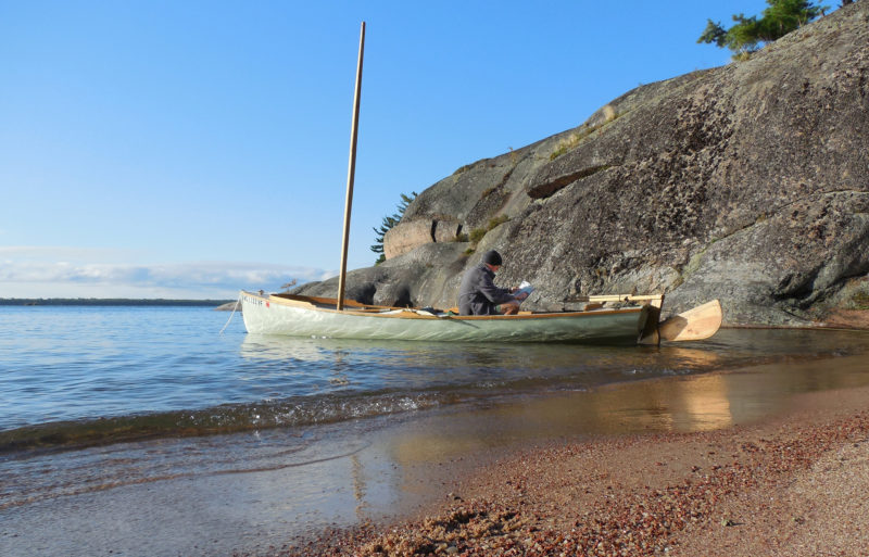
Looking over the chart, here at my South Benjamin anchorage, to pick a destination for the day was my standard post-breakfast routine. With good visibility and no tides or currents, navigation on the North Channel rarely gets more complicated than eyeballing the islands as you sail past.
The west side of Fox Island was all bare-boned ridges, dark pines, and narrow passages cutting through broad expanses of smooth granite. I rowed past the outlying rocks and up into Fox Harbor, a deep inlet I’d never explored before because it was always crowded with deep-draft sailboats and motoryachts. Today it was empty, except for one sloop anchored far up at the head of the narrow bay.
Roger Siebert
.
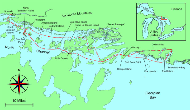
I worked my way up Fox Harbor, making detours up the many side channels and backwaters whenever the opportunity arose. They were dead ends, I knew from the chart, but still worth exploring. Near the head of the inlet I turned to port into one last dead end that led me to a narrow channel lined with cliffs, barely wide enough for my oars. At a few places, with less than a foot to spare on either side of the boat, I had to trail the oars close alongside the hull and let the boat’s momentum carry me through. And then all at once I was past the narrows and into a wide bay—a bay on the north side of Fox Island, and, according to the chart, completely unconnected to Fox Harbor. I had rowed right through a gap that wasn’t supposed to be there, the kind of unexpected opportunity that sail-and-oar cruising has to offer.
I spent the rest of the day working my way through unlikely passages along the edges of Fox Harbor, slipping through channels so narrow I sometimes had to stand in the boat and paddle with one oar. Summer had been rainy, and water levels were about 3’ higher than indicated on the chart, opening a complex web of passages that would have been dry land on my last trip here three years ago.
With the wind out of the northwest at 20 knots or more, I was happy to spend a day exploring the rocky interior of Fox Island under oars. The narrow channels and sweeping granite slabs provide a good preview of tightly clustered islets of Georgian Bay.
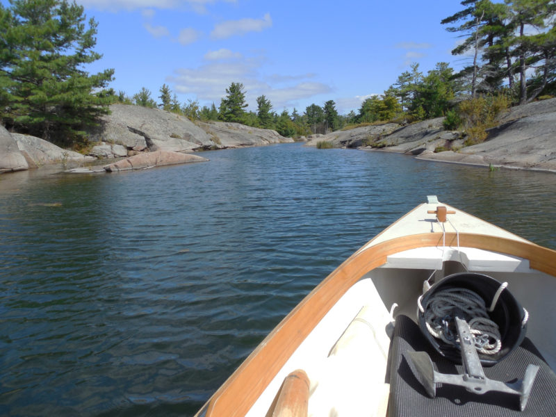
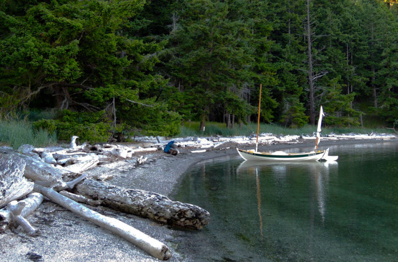
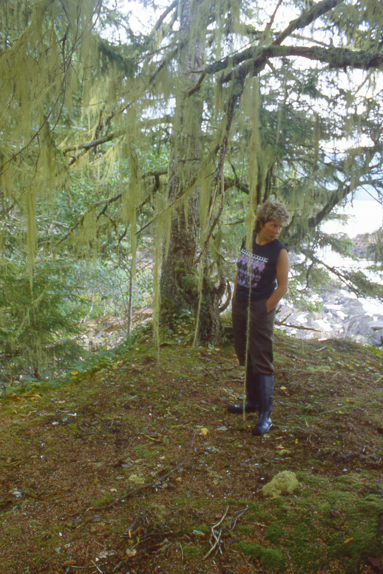
After an afternoon of poking around and keeping out of the wind, I emerged on the south side of Fox Island and followed the shoreline east. After a mile or two, I rounded a corner to find a hidden alcove carved into the stony shore, a tiny bay hardly bigger than my boat. A lichen-spattered granite dome rose 15’ above the water’s edge on one side, with a single stunted pine standing just below its summit. I glided to a stop in a stand of half-drowned willows at the foot of the rocks, tied off to some branches, and waded ashore.
The wind seemed to be dying down. I had a quick snack and wrote some notes in my journal, then set out again under sail. Once out of Fox Island’s lee, though, the wind swept in even stronger than before—too much to face so late in the day. I lowered the sail, dropped the mast, and headed back to the hidden alcove under oars, easier and faster than sailing in this wind. I tied the painter to a stout birch stump, then pulled my gear out of the boat—a single trip, with only two large waterproof duffels to carry—and brought everything up to the top of the dome. I’d arrange things later. For now, leaving the bags at the foot of the lone, sentinel pine, I set out to explore the island. I spent the rest of the afternoon walking broad pathways of bare granite past reed-fringed ponds and forests of white pines and birches. Just after sunset I returned to camp, ate a supper of black beans, tomatoes, and chiles sprinkled with lime juice, then set up my tent at the very edge of the granite cliffs and sat back to watch the darkening sky fill with stars.
Fox Island’s rugged southern shores offer plenty of good campsites overlooking the water, and a pleasant break from sleeping aboard. Here the view is east toward Amedroz Island and the Bay of Islands beyond.
Morning brought blue skies and light winds. I ate breakfast—oatmeal again—and prepped a Thermos meal of red beans and rice for supper. After repacking the boat, I rowed a few yards offshore and raised the sail. After half an hour, though, I’d barely cleared Fox Island, and the breeze was swinging around eastward, forcing me well off my desired course. I dropped the rig and settled in for a long session at the oars. Far ahead, the rugged pine-clad La Cloche Mountains rose from the mainland to the northeast, with a line of big islands—Amedroz, Bedford, and East Rous—forming the southern edge of a broad channel leading eastward. Somewhere just beyond the horizon was Great La Cloche Island and, along its northern edge, the back door to Georgian Bay.
Eventually a westerly wind came up, putting me on a broad reach—perfect sailing. I let my 59-cent autopilot, a simple bungee-and-line tiller tamer, keep me on course. With the wind holding steady, I tied the sheet to an oarlock with a slippery hitch, and sat back to enjoy the ride. The wind grew stronger as I sailed on, the boat surfing the steeper waves with a smooth rush of speed and showing no inclination to broach. Perfect sailing indeed—20 miles of it.
Guarded by extensive shoals and a narrow, winding entrance, this hidden cove at the gateway to the Bay of Islands is a perfect small-boat anchorage. Even in mid-September, the water was warm enough for a brief swim before supper.
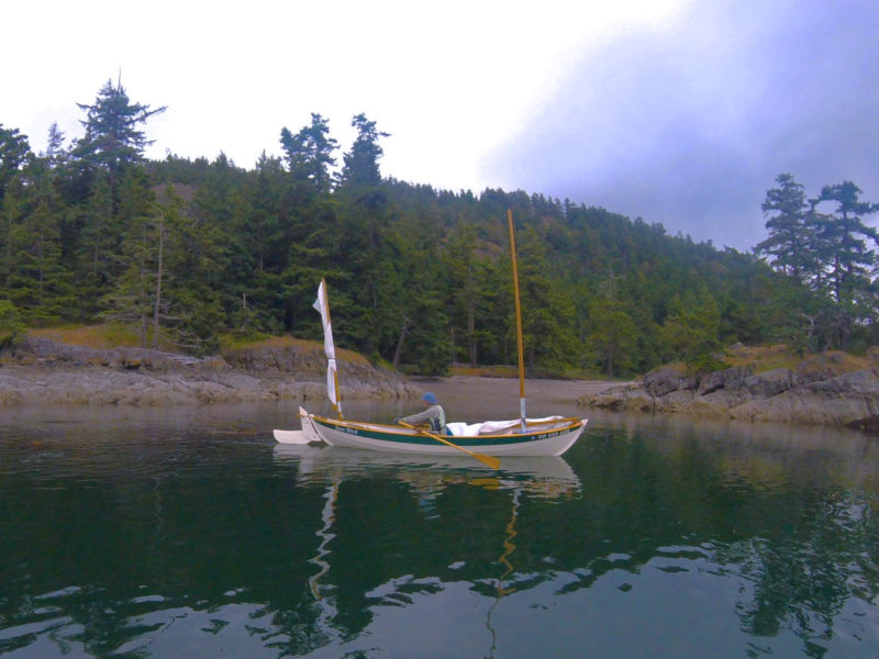
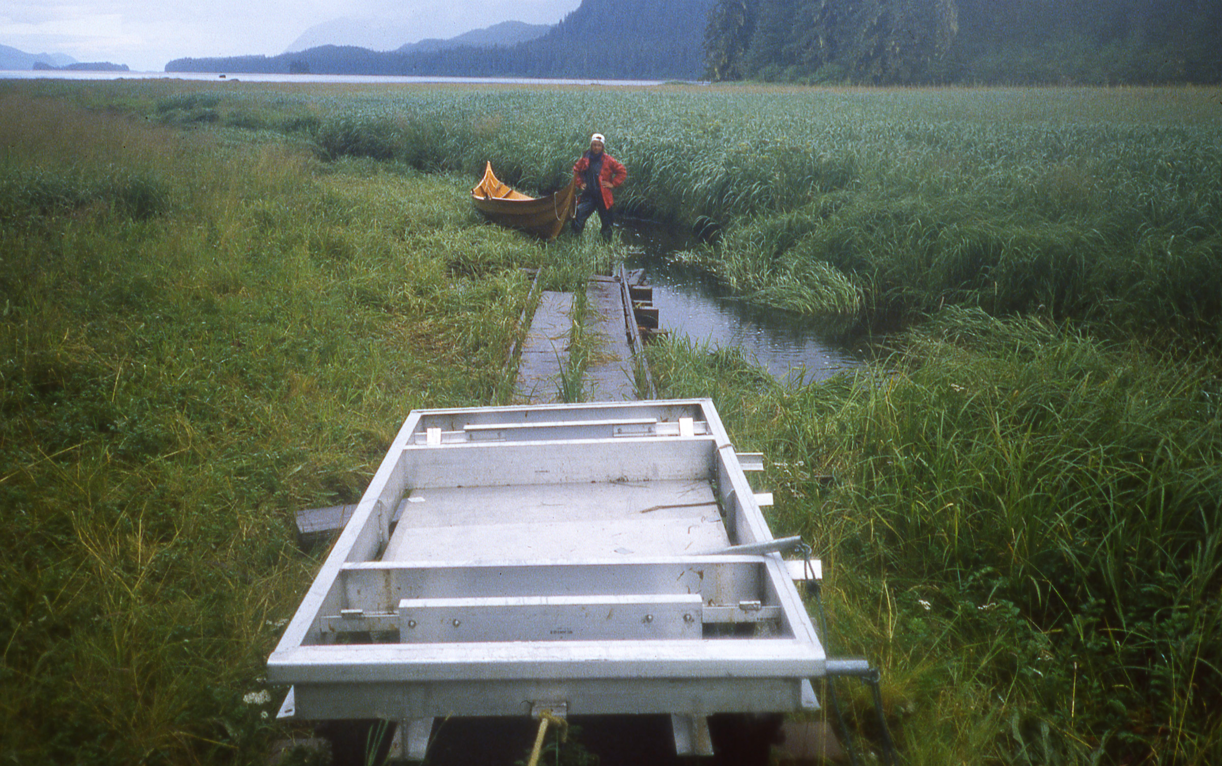
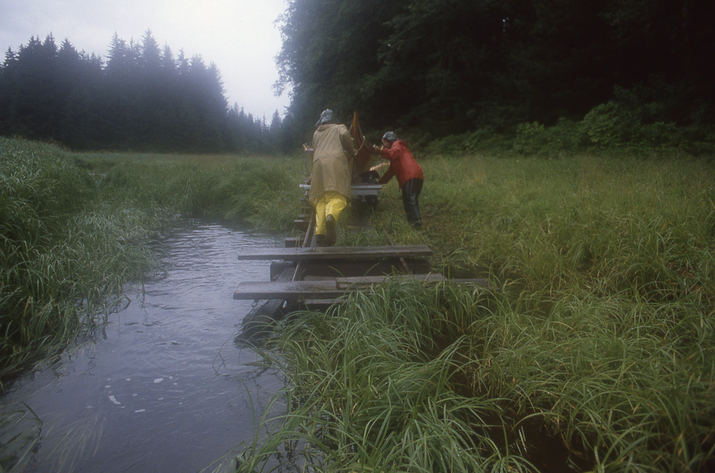
When I reached the entrance to Bay of Islands, I turned up into a beam reach and the strength of the wind suddenly became obvious, then made way up the shore of Great La Cloche Island: a dead-end bay for keelboats, but not for my Alaska. Twenty yards offshore I dropped the rig and rowed through a narrow knee-deep channel that led, eventually, to a sheltered bay hidden between a cluster of tightly linked islands too small to be named on the chart.
I dropped my 6-lb Northill anchor from the stern in the middle of the bay and rowed up to shore as the line ran out, cleating off just as the bow edged toward the rocks. Stepping out into knee-deep water, I took the painter ashore, tied the end to a tree, and headed off to explore, but it didn’t take long. The islands were nothing but jumbled heaps of moss-covered boulders that rolled and clattered underfoot, with nowhere to pitch a tent. I set up the sleeping platform and boat tent and got ready for a night aboard.
I woke in the night to the sound of loud splashing and grunting just outside the boat. Bears? I wondered, but dismissed the idea almost immediately—I’d expect a bear to approach from shore, and these sounds were coming from behind me, out in the water. I pulled up the side of the boat tent. Five or six white-whiskered faces were just visible in the darkness. They vanished with a sudden series of huffs and splashes as soon as I poked my head out. A minute later I heard them surface farther down the bay. Otters. They splashed their way out of the cove and the noise faded to silence. I went back to sleep smiling.
Rowing past Great La Cloche Island on a typically calm North Channel morning, I covered more than 10 miles under oars before the wind came up. I was pleased to find my new Alaska as well-suited for the task as I had expected.
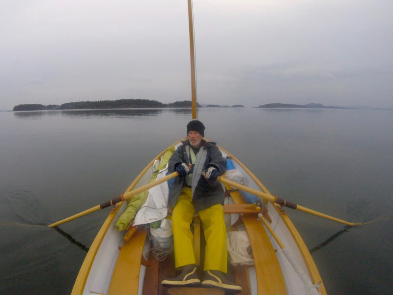
Daylight arrived without wind. No matter—I had oars. I pulled out a can of peaches to eat underway, packed up the boat, lowered the mast, and shoved off from shore, retrieving my anchor along the way. Soon I was rowing east along the north side of Great La Cloche Island, slipping along the southern margins of the Bay of Islands. Somewhere a loon called. Farther on, a bald eagle stood on the rocks at the water’s edge tearing a fish apart.
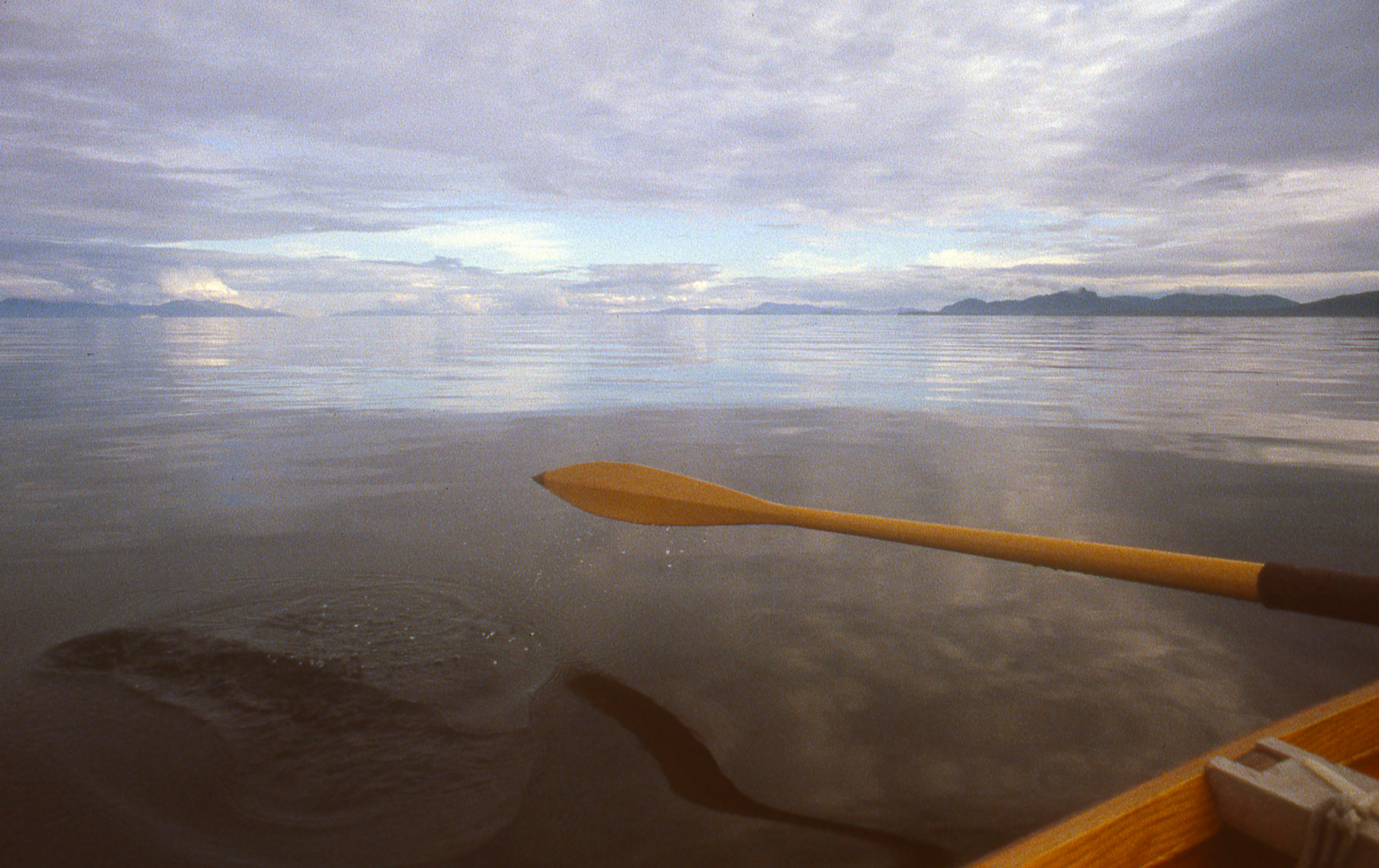
The water was dead flat, and the boat moved smoothly and easily. I was traveling 15’ per stroke, I decided, watching the hull slide through the water. A hundred strokes for 1,500’, 400 for a nautical mile. I pulled out my watch, set it on the bench beside me, and started counting strokes. Twenty minutes later, pulling steadily and easily, I hit 400. Twenty minutes meant 3 knots. And that was moving at an all-day pace, with the oars slipping in and out of the water so silently and smoothly that it felt like the boat was rowing itself. It hardly seemed necessary to have a sailing rig at all.
By late morning I reached the double bridge that joins mainland Ontario to Great La Cloche Island—my secret small-boat passage to Georgian Bay that bypasses the crowds, strong currents, and the open-on-the-hour swing bridge at Little Current on the south side of Great La Cloche Island. The bridges on my route were fixed: too low for even a short mast, and too narrow for oars, making it impassable for larger boats. In my Alaska, all I had to do was pull the oars in close to the hull as we coasted through.
I reached Killarney by early evening, and dropped the sail to row through the narrow dock-lined channel separating the town from George Island. With excellent anchorages just a few miles away at the northern edge of Georgian Bay, I had time for a stop in town to phone home. I pulled the boat onto the grass alongside one of Killarney’s many marinas, called my wife, and bought a few groceries. On my way back across town I treated myself to a local fish fry. As I was leaving, I saw a woman loading some bags into my boat.
“It’s the last day of our trip,” she said as I approached. I hadn’t even asked a question. “And it looked like you could use them in your little boat.”
When I opened the bags I found boxes and boxes of expensive cookies and candies: maple shortbreads maple creams maple peanut brittle maple sugar leaves maple everything. Only in Canada, I thought. And only in Canada would you find people putting stuff into your boat.
There was less than an hour of daylight remaining by the time I left Killarney. Out in Georgian Bay, beyond the end of the narrow Killarney Channel, a strong southwesterly was blowing, sending big waves crashing into cliff-lined lee shores. Not eager to face those conditions in the fast-approaching darkness, I turned back toward town and found a small sheltered bay near the end of the channel, just west of the lighthouse at Red Rock Point. I tied the boat up to a waist-high granite outcropping, slipped a cushion between the hull and the rocks, and set my tent up on a granite slab at the water’s edge.
The little bay was less than a mile outside of Killarney. It might as well have been a hundred. I spent the last of the day’s light looking over the small-craft charts for Georgian Bay, then sat outside the tent on a pile of boat cushions until late in the night, watching the broad belt of the Milky Way fade away with the light of the rising moon before I crawled at last into the tent. I drifted off to sleep to the sound of waves still crashing on the rocks below.
The good weather was holding, but I didn’t trust it. The long low slant of the sunlight, the coolness of the air, the emptiness of the popular anchorages—everything seemed to suggest the end of the season, as if November’s cold winds were waiting in the wings to sweep in and slam the door shut on summer. I didn’t want to be too far from my car and trailer when that happened.
I sailed eastward through Collins Inlet, a narrow cliff-lined passage 10 miles long. With a following wind that grew stronger as the day went on, I kept the boat on a broad reach and tacked my way downwind to avoid unpredictable jibes in the shifting gusts.
I’d left Killarney the day before, sailing a dead run eastward through Collins Inlet, a narrow fjord-like passage that ran for 10 miles along the north side of Philip Edward Island—an inland waterway lined with 50’ cliffs, occasional cabins and cottages, and here and there an outboard-powered fishing boat buzzing past. Now, tacking my way down Beaverstone Bay, the eastern end of Collins Inlet, I knew I’d have to decide soon: continue east to the Bustard Islands, or turn west and begin working my way back toward Spanish.
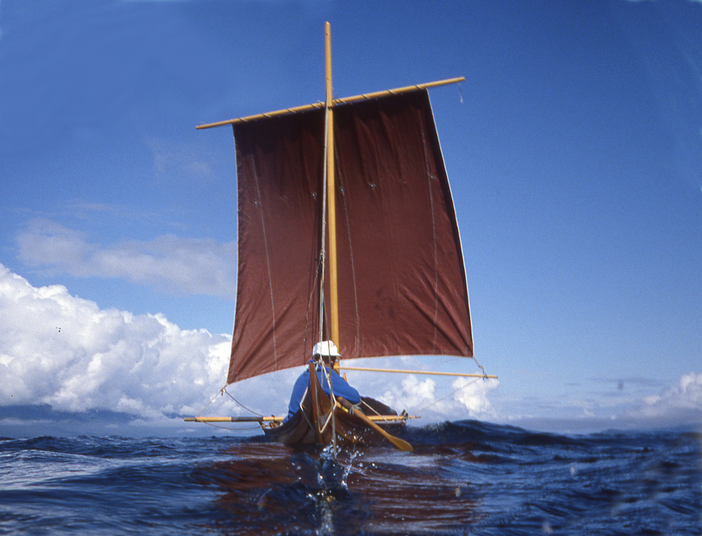
First, though, I had to find a way out of Beaverstone Bay. After a few false starts among the seemingly endless rocks and reefs, I found what I thought must be the entrance to an intricate boulder-studded passage just west of Toad Island. I short-tacked my way out through the gap, fighting strong winds dead on the nose, surging over steep waves that smashed themselves to spray on half-submerged rocks and shoals all around me. The boat handled it beautifully under full sail—I had learned to expect nothing less. It seemed a long time ago that I had been hesitant to set off from the Benjamins.
Once past Toad Island, I kept tacking out into Georgian Bay to get some sea room, heading south past the outlying rocks until there was nothing but hundreds of miles of open water ahead—a broad blue sky, a flat horizon, and an endless succession of waves rolling in from the southwest one after another, row on row, and row on row, for as far as I could see. Two miles offshore, far enough to be clear of shoals and shallows, I luffed up and released the sheet and let go of the tiller, leaving it to my bungee autopilot to hold us steady while I pulled out my large-scale chart. The boat drifted slowly downwind, rolling and yawing with each wave. I made dividers of my fingers and measured distances. It was 20 miles to the Bustard Islands—three days just to reach the islands and return to Killarney, and another three days back to Spanish from there at a minimum. Add time to explore, and I wouldn’t get back to my car until sometime in October.
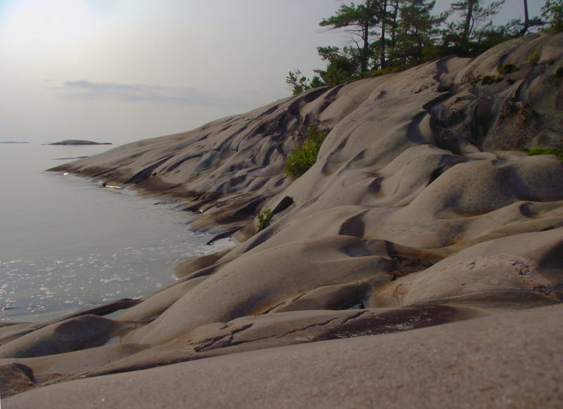
Two nights in the Fox Islands gave me lots of time to explore. While circling West Fox Island on foot, I was caught by the play of light and shadows on the wave-sculpted granite.
I finally decided it was better to turn west and start closing the loop. The Bustards would have to wait. Taking a last look out across the open waters of Georgian Bay, I folded the chart and turned off the wind on the port tack, heading east. Close-hauled, I could just hold a course for the Fox Islands. I hauled the sheet in tightly and moved up onto the rail, smiling as the boat surged forward, shouldering past the waves and sending glittering arcs of spray flying over the water. I leaned farther outboard and reached one hand down to skim the surface of the water as we flew along.
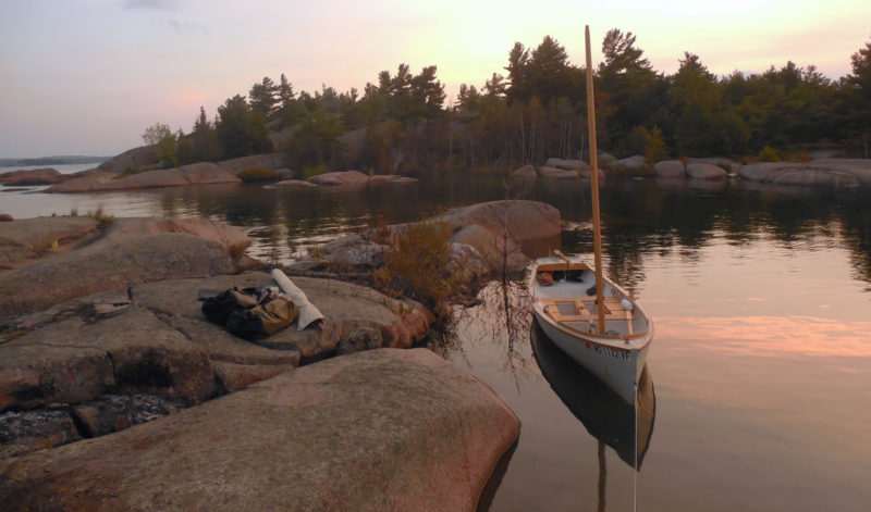
North Benjamin Island’s hidden west-side lagoon is inaccessible to all but the shallowest-draft boats. With water levels 3’ above chart datum this year, the channel was less than 4’ deep.
Late that night, on a broad bare summit at the eastern end of the Fox Islands, I unzipped my tent and stepped out into the darkness. I could hear the quiet rush of waves on the slabs below, the ceaseless surge and retreat of wind-driven water that had scoured and smoothed the rock I was standing upon, and would continue to wear away the edges of the islands, slowly shaping them into fair curves and flowing forms until there is no water left for the wind to move, and no wind to move it.
From somewhere within the shadow of the pines a barred owl called. Slowly the northern sky filled with twisting ribbons of green, gold, and white, broad translucent bands of living light rising from the dark horizon in shifting curves to weave themselves together in silence, glowing brighter and still brighter until it seemed the sky was filled with fire.
I stood and watched until the colors began to fade, then made my way barefoot over cool, smooth stone down to the water’s edge where my boat was waiting, anchored just offshore. Her pale green hull, lit by a quarter moon, was mirrored in dark water that rippled and wavered and reformed itself beneath her with each breath of air until it was impossible to see where the work of human hands ended and the endless smoothing and shaping of the wind and waves began.
If there is one thing that can improve upon a pleasant day on the beach, fresh baked bread might be it.
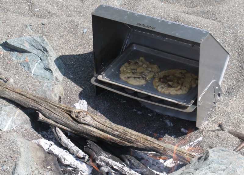
My wife and I went canoeing on our very first date and I proposed to her while we were on a 72-day canoe trip to Hudson Bay. We continued to canoe-camp after getting married, but now that we have kids, I often feel like we are relearning how to enjoy it. The biggest difference is the amount of time we spend in camp. In addition to hauling a huge dry bag full of painting supplies, board games, and books, we started bringing a reflector oven, plus mixes for baking cookies, cakes, and breads.
I once looked forward to camp sweets just as much as our young daughters do now. Pineapple-cherry dump cake baked in a Dutch oven was a staple of my Boy Scout troop campouts. The recipe was easy: dump a can of pineapples and cherry-pie filling in the Dutch oven, top with a cake mix, put the lid on and cover oven with coals. Dutch ovens can be used to make a wide variety of cakes, pies, and casseroles. Many are cast iron, which is way too heavy to carry on a portage, but we often use a lighter, aluminum one that heats almost as well and doubles as a frying pan.
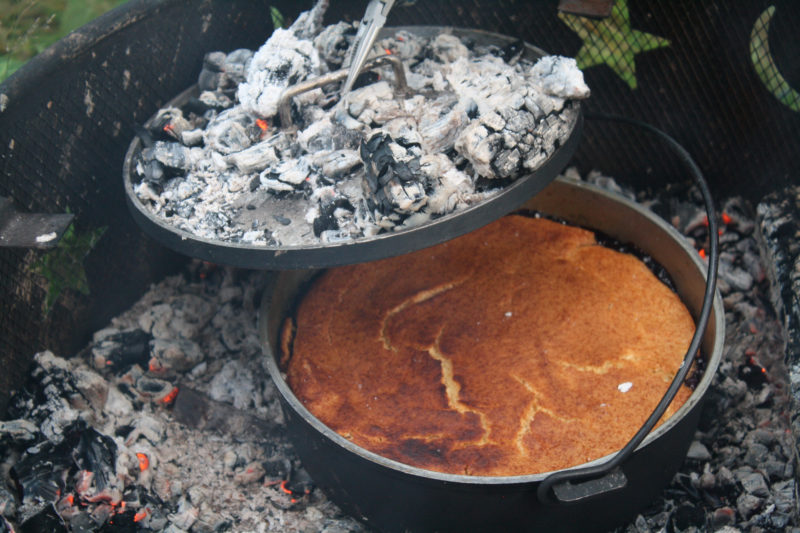
Set in the coals of a fire in a campsite’s steel fire box, an aluminum Dutch oven bakes a blueberry cobbler with the addition of heat from coals set on a lid with a rim.
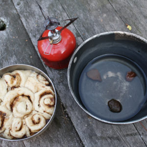
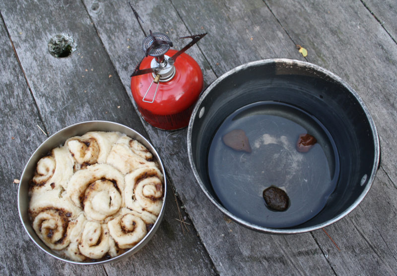
When I started guiding canoe trips, I learned an easier and lighter baking technique for a one-burner camp stove that bakes with steam. It uses two pots—one that fits inside the other. Place a few pebbles in the bottom of the large pot and cover them with water. Pour the cake, muffin, or bread mix in the small pot and set it inside of the large pot. With the lid on the large pot—tinfoil will do in a pinch—turn the stove to simmer. Add more water before it all boils off and the pot gets damaged. Breads and cakes won’t get a crisp brown crust, but they will always be moist.
These peanut butter-chocolate rolls were baked using a pot-in-pot method. Three rocks in the larger put elevate the smaller pot to keep boiling water under the smaller pot. Not shown is the pot lid. The rolls aren’t browned, but they’re fully cooked.
Neither of these techniques is as fun or versatile as the reflector oven we’ve been using more recently. Our oven weighs just 17 oz and folds nicely into notebook-sized pouch. The oven is placed close to the fire and uses radiant heat to cook. It’s more versatile than our Dutch oven because it acts like a regular oven—we’re only limited by the size of pan. I’m careful to keep an even fire heat, and I rotate the baking pan to prevent burning. Like all outdoor baking, there’s no temperature control, so I do a knife test occasionally to see if it’s done. Cookies, cakes, and breads have all turned out great, and I’m looking forward to trying my luck roasting stuffed fish.
Baking in a reflector oven doesn’t require a large fire. Chocolate-chip cookies are almost ready to eat.
If there’s a downside to the reflector and Dutch ovens, it is that you need a campfire. During dry summers, fire bans would prevent their use. When fires are permitted, many places we camp have established fire rings, and other areas (such as the coast of Lake Superior) have rock or sand beaches where fires can be made that have no lasting fire scars, and wood is plentiful. The camp stove used for the pot-in-pot method aren’t often subject to fire-hazard restrictions.
You don’t need to have kids to have a good excuse to add baking to your camp cuisine. The aroma and taste of fresh-baked cinnamon rolls in the wilderness is something you’ll not soon forget.
Andrew Breckenridge is a geology professor living on Lake Superior in Duluth, MN. His fleet includes four canoes, a sailing dory, and a nearly finished Core Sound 17. His current dream trip is the Inside Passage.
Recipes
We usually just use mixes available at the store or find a recipe online. Here are two of our favorites.
Cinnamon Rolls
These were my go-to dessert on layover days when I guided trips for the Boy Scouts.
biscuit mix
sugar (white or brown)
cinnamon
margarine or butter
Nutella
Stir water into the biscuit to make a firm dough. Add some sugar to the dough. Roll out the dough on a flat surface (like the bottom of a canoe) to around 1/4” thick and coat with sugar, cinnamon, and melted margarine. Cut the dough into 1” strips and roll up. Place the rolls into a greased pan, with ample space for them to expand, and bake. Drizzle with Nutella.
15-year-old Birthday Cake
This is the one and only birthday cake I’ll never forget. It was a surprise cake that was served on my 15th birthday during a 9-day canoe trip on the Bloodvein and Gammon rivers in eastern Manitoba. If nothing else, the recipe proves that being on the trail makes everything taste better and creates great memories.
chocolate cake mix
peanut butter
grape jelly
15 wooden matches
Bake two layers of chocolate cake using the package directions and a round cake pan. Spread peanut butter and jelly over the bottom cake layer. Add the second cake layer, then top with 15 matches. Light quickly, and sing even faster.
You can share your tricks of the trade with other Small Boats Monthly readers by sending us an email.
Closed up against rain or cold, the tent is cozy without feeling cramped. The attached flap of PVC vinyl provides a place to take shoes off to keep dirt out of the tent.
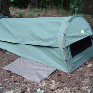
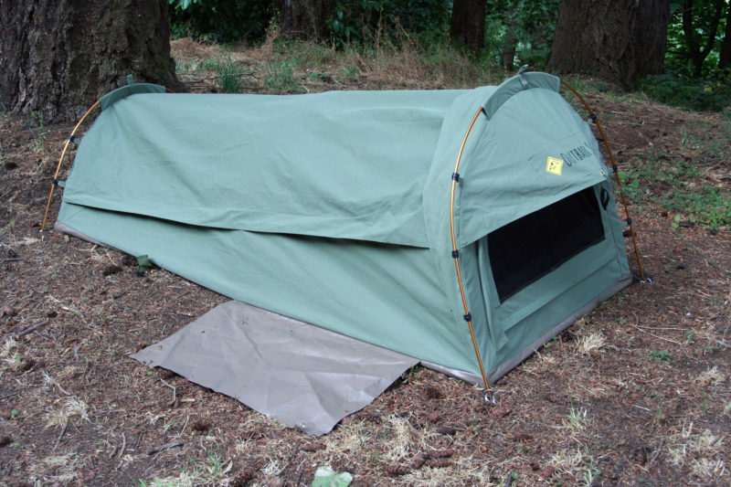
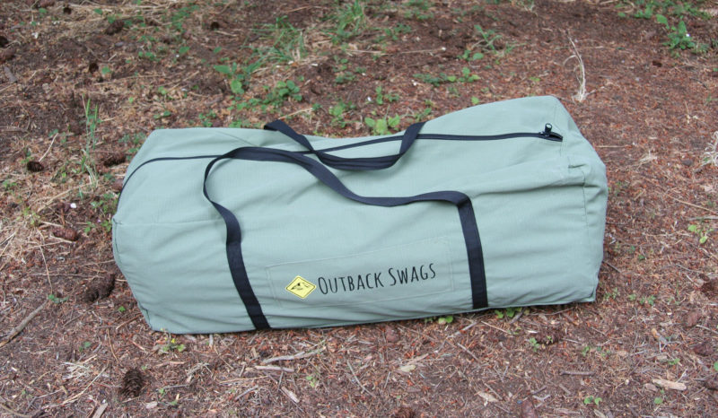
If you learned “Waltzing Matilda” in grade school you might recollect that the song is not about a dancing girl, but about a “jolly swagman camped by a billabong under the shade of a coolibah tree.” The coolibah tree is about the only thing in the song that is what it sounds like, a tree. Waltzing is Aussie slang for traveling on foot and Matlida is slang for a bedroll, or swag. The swagman was a drifter who had fallen on hard times and was looking for work. The song was written in 1895, and these days the term swag has come to mean a portable sleeping shelter falling somewhere in size between a bivibag and a tent. They’re common in Australia, and have recently crept into the North American market.
The swag has webbing and buckles to keep the tent and mattress tightly rolled up.
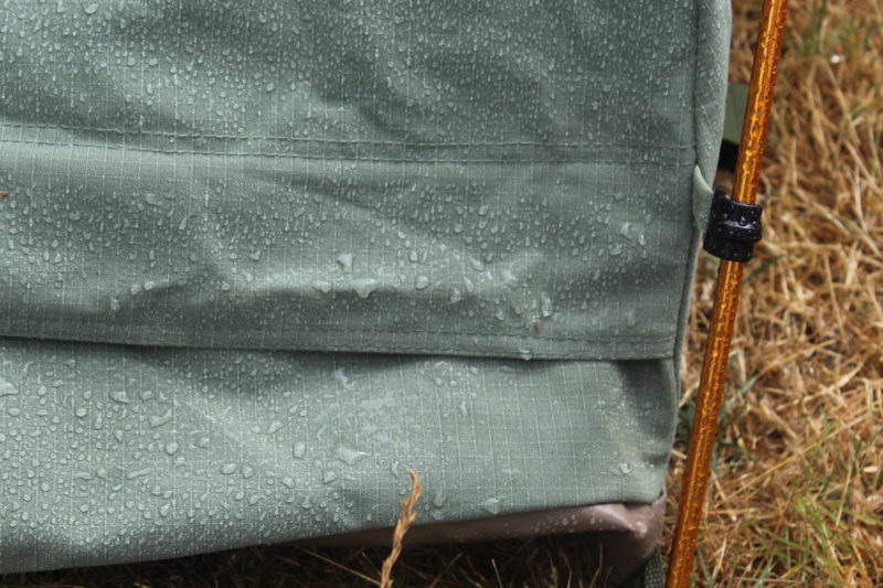
Like drifters, many of us who cruise in small boats need a place to sleep, and a swag tent could be an option worth considering. The Pioneer Swag Tent is made of 12-oz ripstop canvas made waterproof by its tight weave and durable water-repellent (DWR) coating. I poured a quart of water into a bowl I formed with the fabric and left it there for a couple of hours. No water seeped through, and the underside of the fabric felt dry. The rain that fell on the tent overnight beaded up and rolled off.
The instruction included with the swag notes: “All canvas camping equipment should be seasoned. This is when you wet the fabric to let it swell around the stitching. This will make the stitching seams waterproof.” The fabric has been treated with a waterproofing product to make rain and dew bead up and roll off.
The bathtub floor is made of coated vinyl and rises up about 1-1/2″ to meet the canvas top. An extra piece of the vinyl is sewn on to serve as a foot mat. It’s a nice touch that keeps grit out of the bed and stinky shoes out of the tent. I tucked my shoes under the mat and they stayed dry on the night it rained.
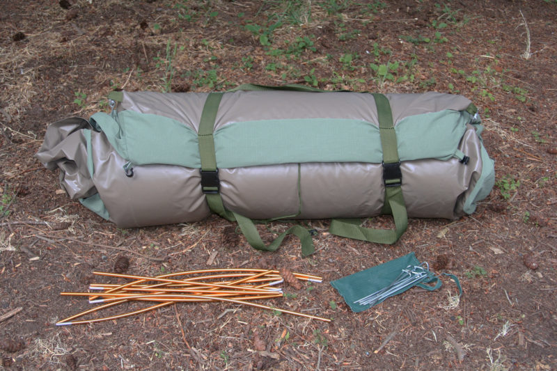
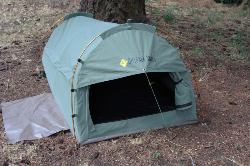
Three sectioned aluminum poles support the tent. Guy lines to two tent pegs pull the canopy tight. Another four pegs anchor the corners of the floor.
Rolling back the canvas top exposes the bug netting and allows a cooling breeze to flow through. The netting can be rolled back as well for entry and stargazing.
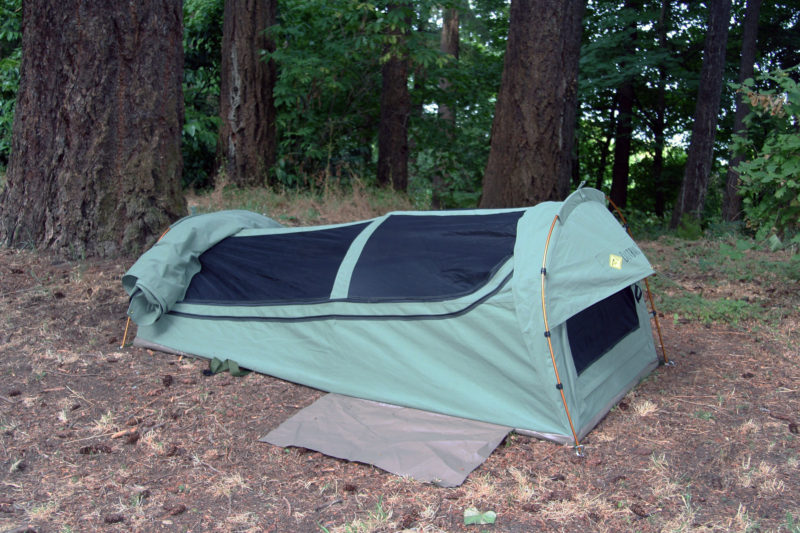
The top of the tent unzips and rolls back to uncover a nearly full-length bug mesh that also unzips to uncover the interior space. The head end of the tent has a doorway with a bit of an awning over it and provides another way to get into the tent. I had enough room in the tent to crawl in through the end doorway head first—easier than backing into it—and I turned around once inside. The tent is 7′ long and 3′ wide, slightly longer and narrower than an American TwinXL bed. At the head end the inside space is 31″ high, 17″ at the foot.
The door at the head end of the tent is rolled up to the right. The opening was a tight squeeze as an entry, but a reasonable option in a downpour. I could crawl in faster head first and then turn around inside. The guy line wasn’t a significant obstacle.
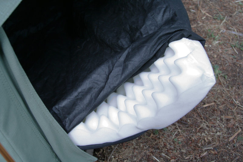
The mattress is egg-crate foam with a non-woven fabric cover, equipped with a zipper to make it removable for washing. The foam is 2” thick and surprisingly comfortable. I’m used to self-inflating sleeping pads that allow me to set a level of inflation that keeps my hips and shoulders off the ground, so with just 2” of foam, I expected to ground out and feel pressure points, but I felt evenly supported and remained comfortable through the night.
The 2″ egg-crate foam, zipped into a washable cover, is surprisingly comfortable on hard ground. I preferred having the textured side down.
There are two pockets inside the tent—one canvas and one mesh—for storage of glasses, a flashlight, and other small items. The tent comes with a zippered duffel made of the same rip-stop canvas as the tent and it’s made oversized to accommodate a sleeping bag. I’d recommend a waterproof duffel or dry bag for carrying the swag tent in an open boat to keep it fully dry and to serve as flotation.
In a timed trial, I set the swag tent up in 3 minutes and 45 seconds and then got it knocked down, rolled up with a sleeping bag and pillow in it, and zipped into the duffel in 3 minutes 47 seconds. The duffel measures 36″ x 14″ x 14″.
The duffel has some extra room beyond what the tent and mattress require, so the swag tent can be rolled up along a sleeping bag and pillow inside and still fit. While the duffel is bulky, it takes up as much space as the four or five separate bags the gear might ordinarily occupy.
The first two nights I slept in the Outback Swag Tent were at the end of summer days with temperatures in the high 80s. With canvas covers the top and the end unzipped, the mesh allowed a cooling breeze to make it easy to fall asleep. On the rainy night, I kept the top cover zipped up and opened the end door for fresh air. On all of the nights I slept in the swag tent, I was just as comfortable as I would have been in my bed at home and I even slept longer.
In the middle of a cool morning, with the temperature at 60 degrees and a bit of a breeze blowing, I stepped into the swag tent for a nap and zipped up the cover. I felt warmer immediately just being out of the breeze. I didn’t have the sleeping bag with me, but I didn’t need it. The small enclosed space and the insulating properties of the canvas are good measures against the cold. In 20 minutes the temperature inside the swag tent had gone from 60 degrees to 78 degrees, warm enough to nap comfortably without a sleeping bag.
The nights I slept in the Outback Swag Tent, I was just camped in the back yard. After one night in it I had the information I needed and could have gone back to my bedroom, but I liked the cozy space and slept well. The Outback Swag isn’t meant for backpackers. At 18.7 lbs for the tent, mattress, poles, stakes and duffel, it’s heavy by backpacking standards, but it’s also heavy duty and should hold up to a lot of hard use providing years of comfortable camping.
Christopher Cunningham is the editor of Small Boats Monthly.
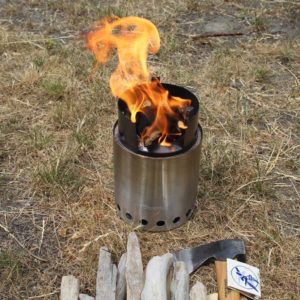
The stove takes some tending to keep it going, but small sticks are all that it requires.
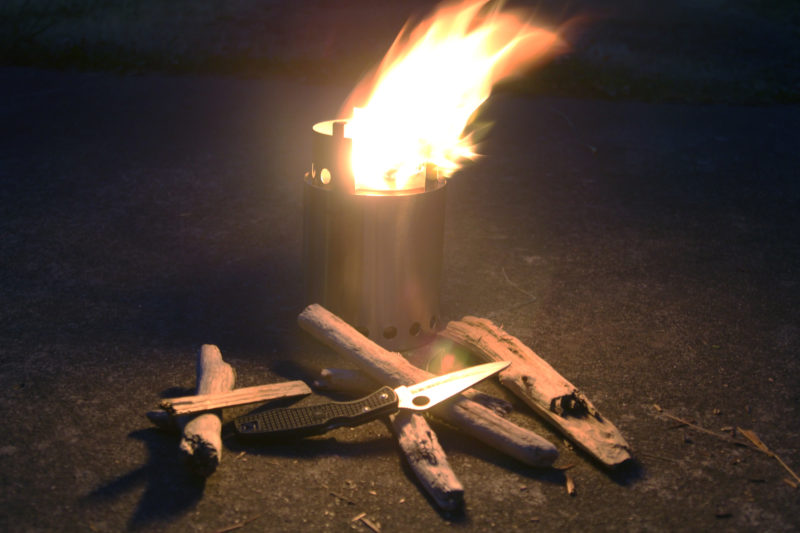
There was a time when a campfire involved clearing the duff from a patch of ground and making a ring of stones. As pleasant as that might have been, it left a scar on the land, both in a circle of scorched earth and butchered trees, living and dead, for firewood. Charcoal tended to get scattered around good campsites, leaving its mark on clothes and camping gear. When I saw the Solo Stoves on the web they looked like a good way to enjoy the benefits of a campfire without being so hard on the natural landscape.
I bought the Titan model, measuring 8″ tall and 5-1/16″ in diameter, advertised as suitable for two to four people. The Lite is the smallest model, listed as a solo backpacking stove for one or two people, but I didn’t need something so compact and could afford to carry a large stove aboard. The two larger stoves, the Campfire (9.25″ x 7″) and Bonfire (14″ x 19.5″) models, are more than I need. A lot of outdoor gear is designed with backpacking and light weight in mind, but the Solo Stove is made of stainless steel at about 1/40″ thick and is just as sturdy as the kitchen cookware that I’ve bashed about for decades.
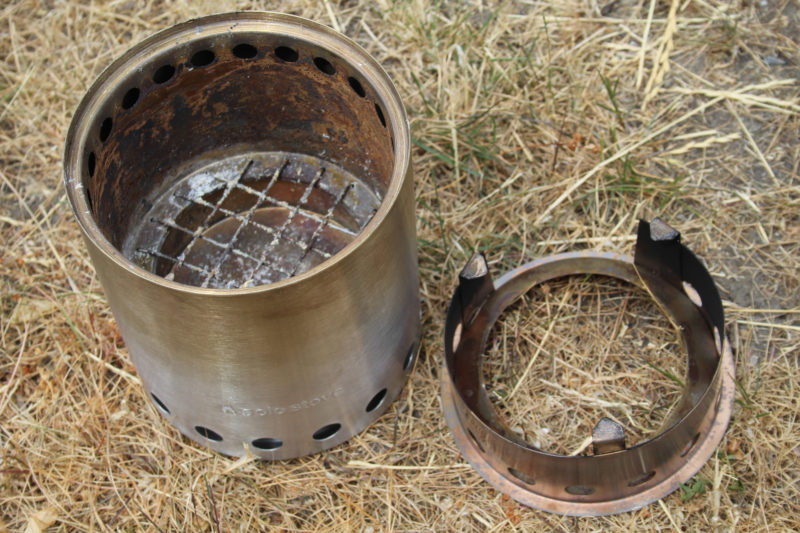
Air enters the stove through the row of holes at the bottom. Half of the air enters the burn chamber through openings hidden beneath the flange supporting the grate; the other half rises between the stove’s inner and outer shells, being heated as it goes, and emerges from the row of holes at the top of the burn chamber. The cookware support is at right.
The stove itself is 5-5/8″ tall and 5-1/16″ in diameter. The cookware support brings the overall height to 8″. There are sixteen 1/2″ holes around the base of the stove. Some of the incoming air travels across the bottom of the inner liner of the stove to a central hole and then to a vent set below a heat-resistant nichrome wire grate that supports the firewood and lets ash pass through to an ash pan. The rest of the air travels upward between the outer and inner walls, getting heated as it goes, and through twenty-two 3/8″ holes at the top of the burn chamber. According to the manufacturer, the heated air results in “a more complete combustion and a hotter fire with less smoke.”
The stove is easy to light and doesn’t take any careful arrangement of tinder, kindling, and firewood. Kindling should be about 3″ long to fit into the stove. A bit of crumpled newspaper, protected from wind by the walls of the stove, catches fire quickly and gets the kindling going. I chopped sticks as thick as my thumb to 6″ lengths. That initially left one end sticking out of the stove, but as the lower end burned away the sticks would fall into the burn chamber.
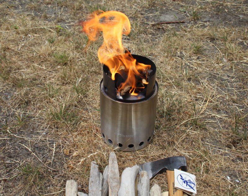
When the fire is going strong there is indeed very little smoke and what does emanate from the stove dissipates a couple of feet above the ground. The visible effect of the secondary-combustion airflow is to concentrate the flame as it flows through the opening at the bottom of the pot support. With a full load of wood burning and no cookware in place, there is a satisfyingly hypnotic flame flickering 12″ high. That’s bright enough to bathe a campsite in a circle of appealing and useful amber light.
At night, the Solo Stove Titan puts up a flame bright enough to illuminate a campsite.
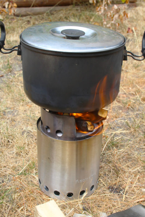
With pot on the support, flames licked the sides, blackening them with soot. I put a quart of water in the pot and the punky driftwood and old yellow cedar, which had lost most of its fragrant and flammable resin, brought the water to a boil in 8 to 9 minutes. The large burner on my electric range, set on high, took 4 ¼ minutes to get a quart to boil in the same pot.
The bottom of the stove is wide enough to provide a fairly steady base for cooking as long as the ground it’s on is level and flat.
Keeping a fire going in the Titan did require having wood ready to load into the stove every few minutes, but not so often that it felt like a nuisance. Tending the fire would fit right in with minding the cookpot. As for gazing into the flame, there’s still plenty of time to slip into that relaxed state between re-stoking.
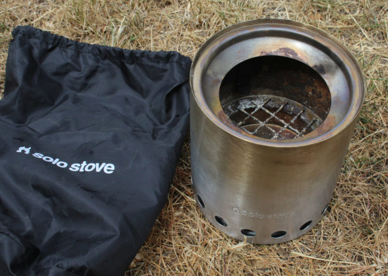
Left to burn themselves out in the Titan, each of the fires I set left only a couple of tablespoons of powdery ash and a few peanut-sized coals in the ash pan. The stove’s double wall kept the bottom of the stove from getting hot; the dry grass that I’d set the stove on showed no trace of scorching. The interior surfaces of the stove got a bit sooty, but the exterior, though colored by the heat, remained soot-free and easy to put away in the included stuff sack without making a mess of my hands.
Soot accumulates only on the inside of the stove, so handling it after it has cooled down won’t blacken your hands. The included stuff sack keeps the two pieces together.
The Solo Stove Titan has a minimal impact on the environment, both in fuel it consumes and the traces it leaves behind. It’ll cook dinner and when the meal is over, it will provide the flickering firelight we have been enjoying for tens of thousands of years.
Christopher Cunningham is the editor of Small Boats Monthly.
Thanks to reader Marty Stephens for suggesting this review.
Solo Stove sells the Titan model for $89.99 through their web site and a network of dealers.
Is there a product that might be useful for boatbuilding, cruising or shore-side camping that you’d like us to review? Please email your suggestions.
From the 1,900′ summit of Mount Maxwell on Salt Spring Island, my wife and I looked out over dozens of emerald islands spread out all along the southern horizon. With their forested slopes and rocky shores, these islands are the broken edge of the land, where a continent buckles under an ocean. I opened my sketchbook and drew each hill and bay, and each shadowed shore rising from a silvery sea. We had caught a glimpse of British Columbia’s Gulf islands while aboard the ferry on its hurried passage from the mainland to Vancouver Island, but as I drew the outline of each island I couldn’t help but yearn to trace their contours in my own boat, following my own route on my own schedule.
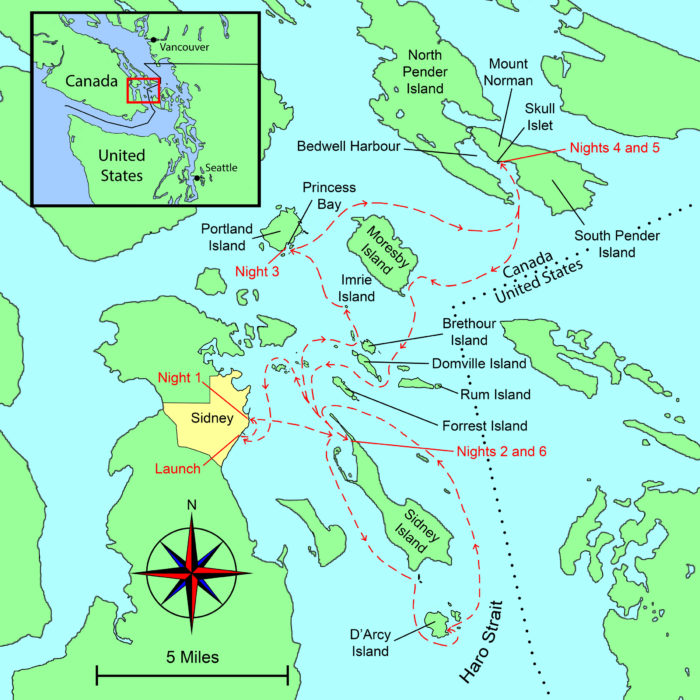
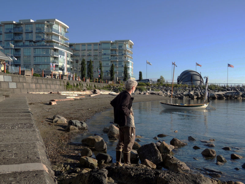
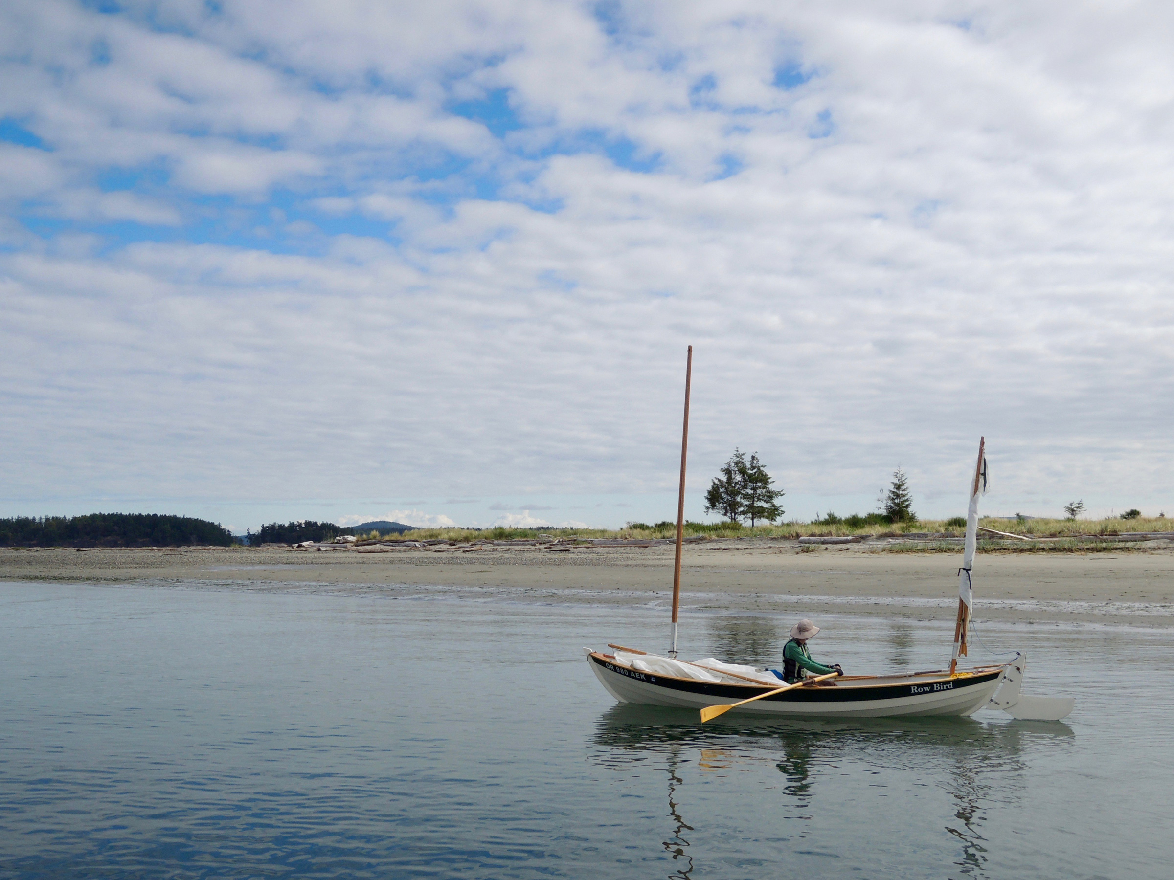
Three years later I slid ROW BIRD, my 18′ Iain Oughtred Arctic Tern, into the waters bordering the town of Sidney on Vancouver Island. I was launching very late in the day—I’d just finished a 200-mile drive from my home in Portland, Oregon, followed by the two-hour ferry ride—but I didn’t mind. Ahead of me I had a week to cruise among the islands I had drawn from the heights of Mount Maxwell, now visible, 8 miles to the north and looming over Sidney’s shore. The southern Gulf Islands, scattered to the east, promised an ever-changing horizon along with the pleasures and challenges of new anchorages.
Roger Siebert
.
I usually sail with friends, but this would be a solo trip with the freedom to do as I pleased without negotiating routes, times, or decisions. If I wanted to spend two nights in a secluded campsite or to row all day, I could. My travel would be limited only by the tides and winds and my goal was to shake myself free of electronic leashes, bolt from thoughts that tie my brain in knots, and find my freedom in the present moment.
The sun had started to set, but the air was still a balmy 65 degrees and the honey-colored water was placid and inviting. It was mid-June, and Canadian kids were still in school, so the flood tide of summer tourists hadn’t started. ROW BIRD was the only boat on the water. With no wake but my own, there was barely a ripple to be seen in any direction. I rowed a half mile north along Sidney’s suburban edge to a cove I’d found while studying satellite photographs on my computer back at home. It had just room enough to allow my boat to swing at anchor between a commercial dock, the boulders protecting a waterfront trail, and a tattered, creosote-stained pier.
As I set up my cockpit tent, three pairs of walkers on the trail stopped to watch me preparing to spend the night aboard. I stretched my nylon cockpit tent between ROW BIRD’s masts, and tied down the rib-like battens that make the whole thing look like a Conestoga wagon on the water. With my sleeping bag unrolled on the floorboards, my pillow and book at the head of my bed, I lay down with a view of waterfront hotels and condos illuminating the edge of town. People watching me from shore must have thought a small open boat would be cramped place to spend a night, but being aboard ROW BIRD felt right; after years of camp-cruising, I knew every inch of the boat, and her familiar motion in the water made it easy to make myself comfortable and content.
photographs and video by the author
Although lacking facilities developed for small boats, downtown Sidney made an easy first overnight and a convenient stop for anything I needed. Within a five-minute walk of the water I found two grocery stores, lots of restaurants, and shops.
I awoke earlier than I’d hoped, thanks to an early-morning delivery truck rumbling by. Soon after the sunlight hit the water I brought the boat to shore, and three people approached. A young couple who love to kayak told me about their favorite stops in the islands. Then a silver-haired woman in an exercise outfit asked where I was headed, and when I told her of my plans, she spoke of her own small-boat adventures through the islands and stared wistfully at the islands a few miles away.
The tide was rising, so I set a 4-lb claw anchor off the stern with an Anchor Buddy, rowed ashore to set my 8-lb Danforth-style anchor on shore and let the elastic stern line pull the boat into deeper water. With ROW BIRD afloat, I headed for Beacon Avenue, Sidney’s main shopping street, and bought a cup of coffee and a pumpkin scone; I was ready to start my journey.
After stowing my anchors in their canvas bags, I took to the oars. I set a course 8 miles south-southwest for D’Arcy Island and listened to the weather report on my VHF radio. In Canada the weather is announced in both English and French, so the broadcast cycle is twice as long as what I was used to. Impatient to get to the English version, I struggled to translate French and convert metric measurements, reaching back to rusty skills acquired in high school. A high wind advisory had been issued for Haro Strait, the dog-leg channel separating B.C.’s Gulf Islands from Washington State’s San Juan Islands.
The wind would be a problem for me because D’Arcy lies in the middle of the 7-mile-wide north-south leg of the strait and is exposed to an uninterrupted 20-mile stretch of open and often rough water to the south. Not quite 3/4-mile long and 1/2-mile wide and without any well-protected anchorages, D’Arcy sits apart from the rest of the Gulf islands and its isolation helped shape its history. For three decades, ending in 1924, it served as a leper colony for Chinese immigrants; during Prohibition it was a hideout for bootleggers smuggling whiskey into the States. Now part of the Gulf Islands National Park Reserve, D’Arcy was high on my list of islands to see, but with the wind predicted to build over the next few days, I had a small window to get there and back.
I should have hustled if I really wanted to explore D’Arcy, but I found the rocky shores of Sidney and James islands were less developed and more enchanting than the San Juan Islands I was familiar with. And no one was out on the water. Wherever I looked, if I saw boats, they were way out in the distance.
I had to navigate rocks, islets, and tidal currents, keeping an eye out for the many ferries that use Sidney as a hub. They generally stay on a defined route, but some of the passenger ferries reach speeds of up to 30 knots and can sneak up in a hurry if you’re not paying attention.
After three hours of rowing and slow, close-hauled sailing, I approached D’Arcy’s north end—a craggy, coarse shoreline behind offshore rocks and beds of hose-like bull kelp. A few fragments of lichen-encrusted concrete walls, the remnants of the leper colony, stood eerily at the edge of the forest. The wind was patchy as I neared the kelp beds, so I raised the centerboard and took to the oars. Kelp wrapped itself around the blades like spaghetti spun on a fork, forcing me to stop every few strokes to free my oars.
The large logs lining the shore of D’Arcy Island are a testament to the strength of the winds and storms that hit the exposed southern shore. Visitors arriving by kayak and other hand-carried small craft can take advantage of a primitive campground near the cove, but I had no safe place to anchor if the water got rough.
I rowed the mile around the west side of the island and arrived at the southernmost point close to low tide. Bony fingers of jagged granite stretched into the water. Even for a small boat, this was a treacherous place to maneuver; every few strokes I had to look over the bow for unseen rocks. After several moments of uncertainty, I spotted a silvery mast behind a rocky outcropping and knew I’d come to a place more suitable for landing.
“Ahoy,” I called to a deeply tanned man relaxing in the cockpit of the sloop, “how’s the anchorage here?”
“Fine now,” he answered. “But I was anchored out here recently, and that time it was too rough to go ashore and too rough to leave. I didn’t sleep so well.”
If the wind that had been forecast didn’t kick up I could spend the night anchored here near the gravelly beach, so, hoping for the best, I pulled the bow of my boat ashore and set an anchor near the beach wrack from the last high tide. I spent a few hours exploring D’Arcy’s brushy trails and drawing in my sketchbook, but late in the afternoon, the treetops above me swayed as the predicted southerly front arrived. Thinking of the sailor’s recent experience, I decided that staying could make for a dicey situation. I boarded ROW BIRD and headed north for the more sheltered waters that the other Gulf Islands could provide.
Although I had been looking forward to spending a quiet night at D’Arcy, I wasn’t disappointed by the change in plans. I had no specific route to follow, just a list of places I wanted to see, and the weather, tides, and currents would guide me. Content to go with the flow, I felt a greater sense of freedom than I would have had if I’d held tightly to a fixed itinerary that put me at odds with the elements.
The locals warned me that Sidney Spit can get quite crowded during the summer when the passenger ferry is bringing visitors from the mainland, but I arrived in the off season and it was very quiet.
The front’s early wind provided a gentle push and I sailed northward on a broad reach, winding my way through a series of rocky islands, uninhabited but for the scores of seabirds I could hear calling in the distance. Sidney Spit on the north end of Sidney Island’s was the one bit of island coastline that was free of rocks, but I was unsure about it as a place to go ashore, having read that it can be as crowded as Coney Island on a hot summer weekend. But when I approached the slender mile-long neck of sand at the north end of the island that evening, just two people were strolling the beach; a quiet group of kayakers had settled in at the campground, and a few larger craft were tied to the mooring buoys, and floating above a vast eelgrass bed. The dock was empty—I’d have it all to myself. At dusk, voices in the distance softened, then grew quiet, and the only sound was the wind ruffling my cockpit tent.
Just before dawn I was awakened by a raft of river otters foraging and splashing around the docks; I got up before the sun was in the sky, and the light scattering of clouds indicated a clear day ahead. I intended to head northeast toward the eastern Gulf Islands that back up against the rough waters of the Strait of Georgia. The first step was to make the 8-mile passage to North and South Pender, a pair of islands separated by a slender 30-yard-wide gap. During the night, the flood tide had flowed into the 100-mile-long strait and in the early hours of the morning all that water retreated on the ebb, straining through the passages between the Gulf islands. I tried to time my departure to coincide with the slack tide’s still water and catch the flood that would push me much of the way to the Penders, but my start was a bit too early, and I made it only about 4 miles.
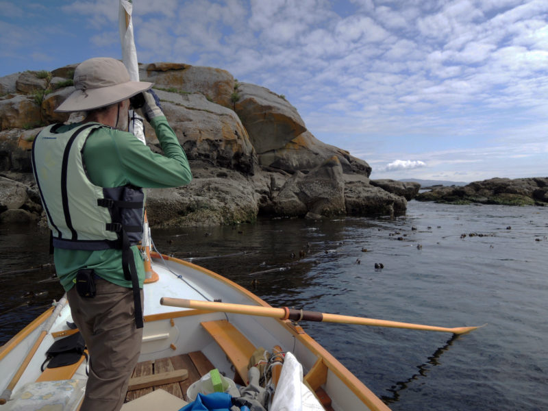
Traveling by a shallow-draft boat let me get in among the kelp and massive rocks to watch intertidal life and seabirds. I made a temporary anchor by wrapping the painter around a few thick stalks of kelp.
I had to tie my boat in a patch of kelp off Imrie Island, a 70-yard-wide grassy islet, and wait out the last of the ebb. It was a peaceful place to be—the kelp dampened the waves and the patches of smooth water between its stalks provided a clear window to the underwater world. Milky white jellyfish the size of saucers pulsed below, and dull-green fish hid in the kelp fronds. Oystercatchers with their bright blood-orange hued beaks paced about their stony nests on the outcroppings of lichen-tinted rock surrounding Imrie.
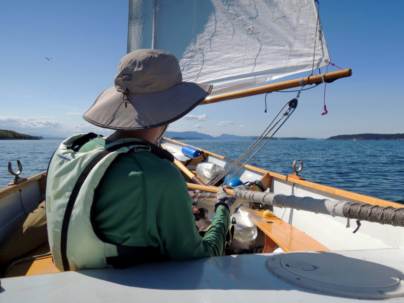
By the time the tide turned and the flood began to work in my favor, an intensely puffy headwind was blowing from the northeast against the current, causing steep choppy waves with a height that matched to ROW BIRD’s freeboard. Each time ROW BIRD started to move, there was a moment of quick acceleration, then heeling, followed by spray splashing over the gunwale. When I stopped to put another reef to the mainsail, I drifted toward half-submerged rocks. Setting the newly shortened sail again just in time, I slid away from the rocks.
The sound of water on the hull made it seem like ROW BIRD was rushing forward, but in the sloppy waters our actual speed was a crawl. Keeping the boat flat was the main thing on my mind, but after a few minutes, I realized that if I was going to make forward progress, I’d need more sail up, so I stopped and let a reef out. I hauled the main up again and while the chop persisted, this time there was almost no wind. Seconds later it reappeared, shot the boat forward and only by hiking out, something I never do in ROW BIRD, was I able to keep the rail out of the sea.
The winds were irregular but never entirely absent, so I usually rowed with the masts up, ready to take advantage of any breeze that might pipe up.
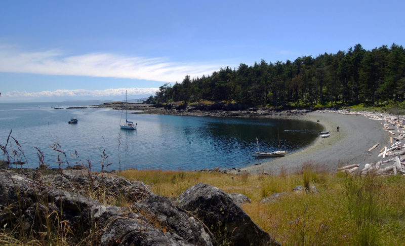
I had to concede that the water was too rough, so I abandoned Pender as my destination for the day. Portland Island was about 3 miles to the northwest, and I figured I’d find easier going in the sheltered coves on its south shore, so I steered for Princess Bay, the island’s biggest anchorage. Initially, I couldn’t see the ¼-mile-wide anchorage even though I was looking right where it should be, but as I got closer the islets that masked its entrance seemed to separate themselves from the island creating openings that had looked, just a few minutes earlier, like an unbroken wall. The water in the bay was still and flat, sunlight glinted off the smooth water, and crooked, weathered trees clung to the rocks at the edge of the bay.
I set my anchor and started cooking dinner. ROW BIRD’s cockpit is snug but the floorboards have room enough for my kitchen activities. Sitting cross-legged, I tended my camping stove, which I set near the centerboard trunk. I mixed couscous in a dried lentil soup mix, added water, slowly stirred and simmered it to a thick, mortar-like consistency. Then I turned the stove off, covered my concoction and waited until the pot cooled enough to hold in my bare hands. As I ate I was warmed by a small south-facing cliff that radiated the heat it had gathered from the day’s sunlight.
The anchorages at Portland Island range from open bays with sandy bottoms to steep, rock-bound coves. Ferries, like the one just coming into view at left, leave wakes known as “ferry wash” and can cause rolly conditions. It’s best to get the boat off the beach before the wake hits and, at night, to anchor with a stern line tied on shore to keep the bow facing the wakes.
The next morning I got up early to catch the flood tide toward the Penders, hopeful I’d reach the pair of islands this time. I put my drysuit on but the cool gray sky chilled me, and as I emerged from Princess Bay, a breeze from the southwest filled from behind. The tidal atlas indicated that a shift in the current’s direction lay ahead and I anticipated bumpy sailing.
Through my binoculars, I saw dark ripples in the water and low-lying rocks near the northwest edge of Moresby Island. Rounding the dark line a few minutes later, instead of the sailing getting gnarly, the wind abruptly died, and I took to the oars, leaving the sails up, and “motorsailed.” When smooth, leaden water between Moresby and Pender islands stretched as far as I could see, I dropped the sails and continued rowing. I set a course across 2 miles of open water toward the Penders and lost myself in the rhythm of the oars.
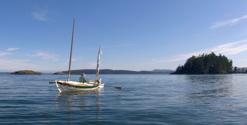
ROW BIRD handled the changeable spring conditions well, including calms, lumpy seas, and strong winds. The mizzen sail is a useful safety feature for heaving-to.
The pale rocky cliffs of North Pender shimmered in the tiny ripples around ROW BIRD as I drew near the island. Pigeon guillemots, soot-black but for white patches on their wings and comical cherry-red feet, came and went from their nests in the cliff’s hollows 50′ above me. Then, with a quarter mile left to go before making the entrance to Bedwell Harbour, a 2-1/2-mile-long inlet between the two islands, I felt myself being pushed back. An unanticipated current seemed to be pouring out of the harbor. The flood should have been flowing in by this point, pushing me into the harbor, but I was being moved south away from the island. I pulled hard on the oars to keep myself from being carried toward open water. I crept through the current and eventually glided into slower moving water on the opposite side of the mile-wide entrance.
I poked along the north shore of South Pender Island, weaving around huge boulders rising from the water—arranged as if they were in a Japanese stone garden—and skirting the towering hills that rose from a gray band of deeply fissured rock. The breeze was light and fluky, but after the hard pull on the oars, I couldn’t be troubled to row to the campground, so I raised the main and mizzen and sailed slowly up Bedwell Harbor.
The Beaumont campground by Skull Islet, like others in the Gulf Islands National Park Reserve with protected beaches and easy access to well-maintained tent sites and trails, are geared toward small boats.
I came ashore at the Beaumont campground on the shore of South Pender. ROW BIRD was the sole boat there; the whisper of the wind in the trees was interrupted only by the calls of birds. The beach was a shell midden, white with countless bleached fragments of shells that crunched underfoot.
After I set up my tent, I walked the steep Mount Norman trail. By the time I reached the 800′-high summit, the highest point on the Penders, my shirt was soaked in sweat despite the cool air. From an observation deck above the trees, I stared out at the islands below, tracing my route to the campground below and envisioning where I’d go next as I drew the scene in my sketchbook.
First Nations people in British Columbia still use parts of the National Park Reserve for traditional hunting and gathering and some areas, such as the burial ground on Skull Island (seen off the bow), are closed to the public as a sign of respect to the local tribes.
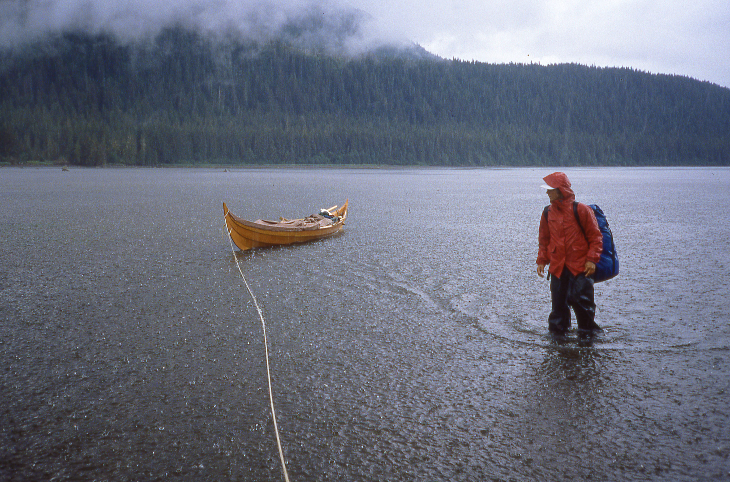
At dawn the next day, I sat on the shell beach looking over to Skull Islet, a round, 60-yard mound of slanted rock strata crowned with a dozen trees that was a burial site for First Nations people. The harbor waters were tranquil, but the weather radio predicted a strong storm two days out, and I knew I’d have to run for home or hunker down. I reviewed the tidal atlas to see where I could go with my remaining two days. Its arrows marked the flow of water through the islands that would push me north, south, or east—all the wrong direction—so I’d likely need both days to get safely back to the ramp at Sidney.
I spent the day at camp, and the following morning I headed homeward through the choppy waters of Haro Strait. Once I cleared the 2-mile ope- water crossing, I hugged the south shore of each of the Gulf Islands I came to. The intricate shorelines, rocky outcroppings, weather-worn shingled cottages, and meadowy pockets offered much more to see than the open water the shortest course would have taken me through. None of the islands—Moresby, Rum, Brethour, Domville, Forest—offered a good place to anchor for the night, so by late afternoon so I had decided to return to Sidney Spit for my final night.
The plip-plop of rain on my tent started slowly as the morning sky lightened. I sat on the floorboards, tidying up the cockpit, reluctant to don my raingear and head back to Sidney and bring an end to the trip. Low clouds blocked the sunrise. I eventually got underway and despite the drizzle, decided to loop around some of the islands closest to the town of Sidney before heading to the dock.
The Gulf Islands are in Vancouver Island’s rain shadow. While the west coast of Vancouver may receive more than 120″ of rain a year, the east side can receive less than 35″ annually.
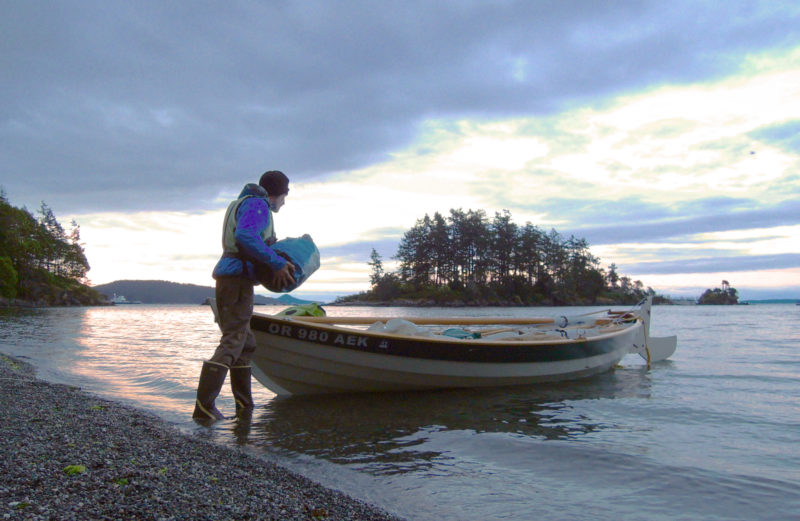
ROW BIRD slid through the still, rain-flecked water as I rowed past the end of the spit. A half mile later the flag on my mizzen, a navy blue silhouette of a bird in flight on a white field, flickered about, so I set sail. As the wind grew, the hull started to hiss as it cut through the water. Close-hauled, I traveled past a cluster of rocky islets called the Little Group. When spray started to splash aboard and darker clouds approached from the south, I sensed that the full force of the predicted storm was coming. Soon, I had to feather the mainsail to handle the gusts as ROW BIRD bounced along parallel to the Sidney waterfront. I was in control for the moment, but I knew that with the rising wind, it was time to head in.
Two hours later, having put ROW BIRD on her trailer, I stood overlooking the cove where I spent my first night in Sidney. The flags along the edge of town snapped and blew straight back. Eastward, whitecaps covered the water between the shore and the nearest islands.
I ducked into a café for a cup of tea. As I flipped through my sketchbook, I paused at the drawing of the islands I’d made with pencil and pen, brush and watercolor at South Pender on the summit of Mount Norman. I had sailed the archipelago and now knew something of those islands, rocks, and coves. I’d traced their edges with ROW BIRD’s wake and filled the space within their outlines with my footsteps.
Bruce Bateau, a regular contributor to Small Boats Monthly, sails and rows traditional boats with a modern twist in Portland, Oregon. His stories and adventures can be found at his web site, Terrapin Tales.
If you have an interesting story to tell about your adventures with a small wooden boat, please email us a brief outline and a few photos.
Seen here in the protected waters of Matia Island, IRONBLOOD slips along easily under oar power.
"After moving ashore from my first schooner, and having acquired a wife and a small son,” writes Michael Colfer of Bellingham, Washington, “I realized I needed a smaller boat.” He started his search for a boat appropriate to his new life by building a Nutshell pram. It proved too small, so he next built Pete Culler’s Good Little Skiff. Christened SHAMROCK and rigged with a spritsail, it served well for cruising the San Juan Islands and camping ashore on state park campgrounds, but while the skiff did well sailing the protected waters within the archipelago, Michael wanted a boat capable of taking on some more challenging weather in the more exposed areas around the archipelago.
Michael Colfer
The augmented keel and skeg improve upon the faering’s sailing abilities without obstructing the boat’s interior with a centerboard trunk.
In his search for a more seaworthy beach cruiser capable of carrying more gear, Michael found his way to faerings and variations on the theme by Joel White (16′ Shearwater), Iain Oughtred (14′ 11″ Elf and others), and John Atkins (18′ 7” Valgerda). All three of these designs were inspired by Hardanger faerings of southwest Norway and had similar shapes below the waterline.
Michael Colfer
Michael built two boats to his design: IRONBLOOD (at the end of the dock) for himself, and a then unnamed faering for his son. The plan was for the two to sail and row the Inside Passage, but family obligations took precedent. After sea trials, the second faering was sold.
Michael bought plans for the Shearwater and although White’s dimensions and drawings make it possible to build without lofting, he lofted the lines and began making some modifications that would make the boat well suited to all Puget Sound waters. He added freeboard throughout and extra height to the ends to provide a dry ride in steep chop. To keep these modifications from increasing the width along the sheerline, he made the sheerstrakes closer to vertical. His changes brought the length to 17′ 3″.
Michael Colfer
Easily removable thwarts and broad floorboards provide room enough for bedding down at anchor.
He wanted to improve upon the boat’s sailing abilities but didn’t want a centerboard trunk cluttering up the boat’s interior, so his keel is deeper than that of the Shearwater, adding only a little at the bow and increasing the depth to 7″ at the stern for additional lateral resistance. The change was also meant to protect the rudder, making its removal unnecessary when landing on beaches.
Michael Colfer
IRONBLOOD is quite at home in the San Juan Islands, both in the quiet coves and in the passes that funnel tides and winds.
Michael added storage compartments fore and aft for dry storage of his cruising gear. The aft compartment has a sloped bulkhead to make a comfortable backrest when taking the helm while sitting in the bottom of the boat. The three removable rowing thwarts clear the interior for a night spent aboard at anchor. The floorboards provide a flat, level platform for sleeping.
Robert Bumpus
The loose-footed sprit sail makes sailing about as simple as it gets. Light summer breezes make for unhurried passages between islands.
Michael christened his faering IRONBLOOD, drawing upon the meanings of his surname, Colfer: col is a Gaelic word for blood, as in blood relative, and fer is the French for iron. IRONBLOOD would be at home in the fjords of Norway, but sails the waters of Puget Sound. She can carry enough gear for a week’s beach camping for two, makes way under oars well, and is stable and smooth under sail, making very little leeway.
Michael Colfer
Waters along the northern perimeter of the San Juan archipelago can get quite choppy—winds from the north and northwest have 15 nautical miles of fetch. The higher ends and freeboard keep the going drier. Here IRONWOOD is bound for Matia Island.
Michael says that IRONBLOOD “will run like a scared rabbit for hours at a time given the right conditions.” The increased height at her ends keeps her dry in a chop as he intended.
He writes: “I have had her now for 12 years, and even though I am sure I will build other small boats, I doubt that I will ever sell IRONBLOOD. She is perfect for me.”
Have you recently launched a boat? Please email us. We’d like to hear about it and share your story with other Small Boats Monthly readers.
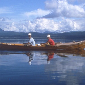
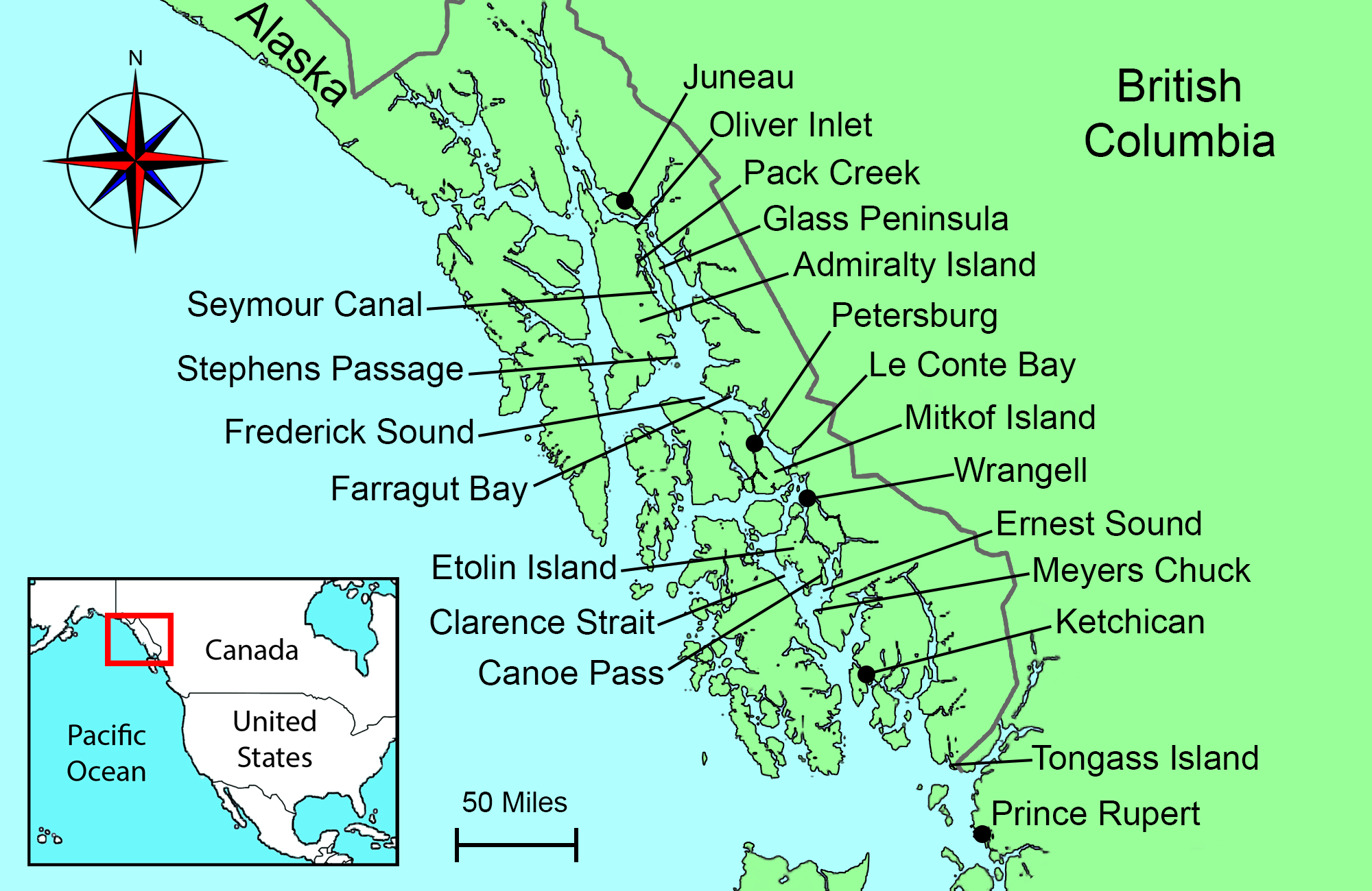
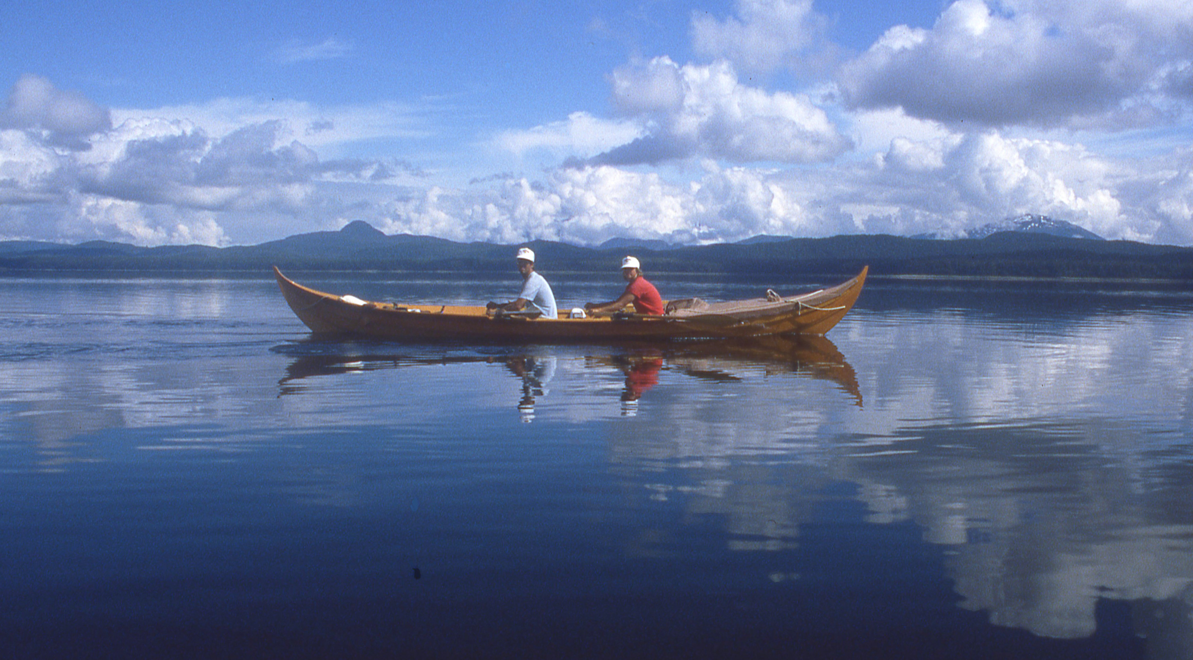
Five weeks into our 1987 voyage from Puget Sound to Juneau, Cindy and I were well into the daily rhythm of life aboard ROWENA, the 21′ Gokstad faering I’d built for the trip. After traveling the Inside Passage through British Columbia we were leaner and stronger, our hands and our butts had toughened up, and we could row long hours, often covering over 30 miles in a day.
Photographs by the author and from his collection
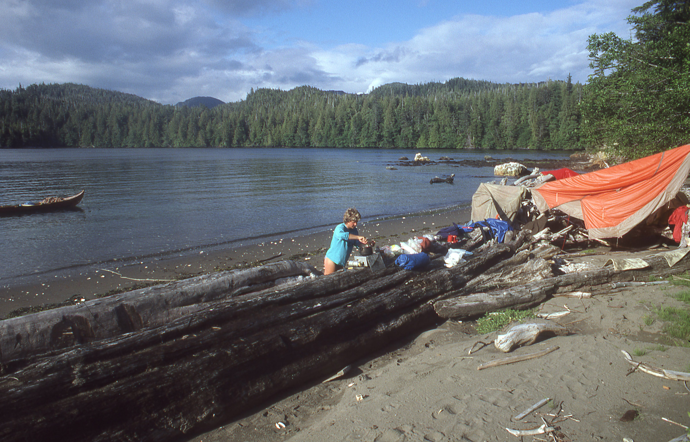
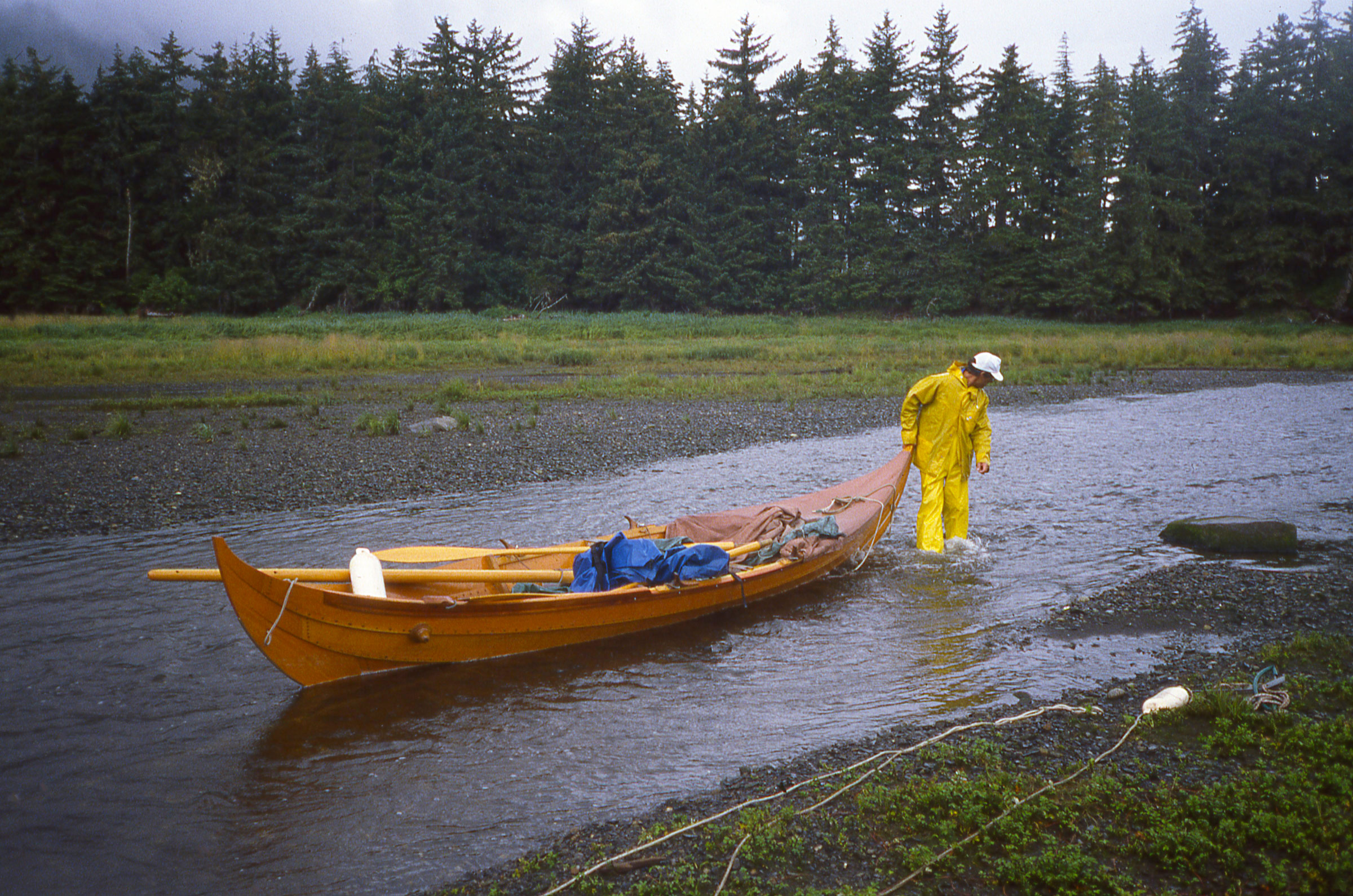
Our first landing in Alaska was on Tongass Island, the site of a U.S. Army fort in the late 1800s and a native village after that. The only remains of the settlement we saw were fragments of brick scattered on the beach. A heavy rain had soaked our tent the previous night and we spread it out to dry.
Our first camp in Alaska was on Tongass Island, just 6 miles north of the US/Canada border and the site of an Army fort established in 1868, a year after Alaska had been purchased by the U.S. from Russia. The only remnants of the fort and the native settlement that later took its place were fragments of brick scattered among the white-quartz cobbles along the beach. With ROWENA anchored, we took a walk around the island. Cindy found a large yellowed tooth, perhaps from a bear and we saw in the dirt paw prints as big as my hands. I picked up a weathered beer can and filled it with a few pebbles to make a rattle to announce our presence to whatever company we might have on the island. Back at the beach I spread our tent out to dry on the driftwood at the top of the beach—it had rained hard during our last night in British Columbia—while Cindy cooked potatoes, carrots, cabbage and beans for dinner.
Roger Siebert
.
The Tree Point Lighthouse dead ahead faces the open Pacific Ocean. Automated in 1969, it guides mariners across Dixon Entrance. The area can be quite rough, but we had an easy row around the point into Revillagigedo Channel.
We woke to the alarm at 5:00 a.m. and got underway during the morning calm to round Cape Fox, the most exposed promontory at Dixon Entrance. Long fingers of dense fog stretched seaward out from the pass to the south of Tongass Island and from Portland Inlet just beyond the border, but we had good visibility to the north and got around the Cape and the tall white lighthouse at Tree Point with only a northeast breeze and some chop to contend with. Farther north, Revillagigedo Channel was quite calm under clear skies and easy going.
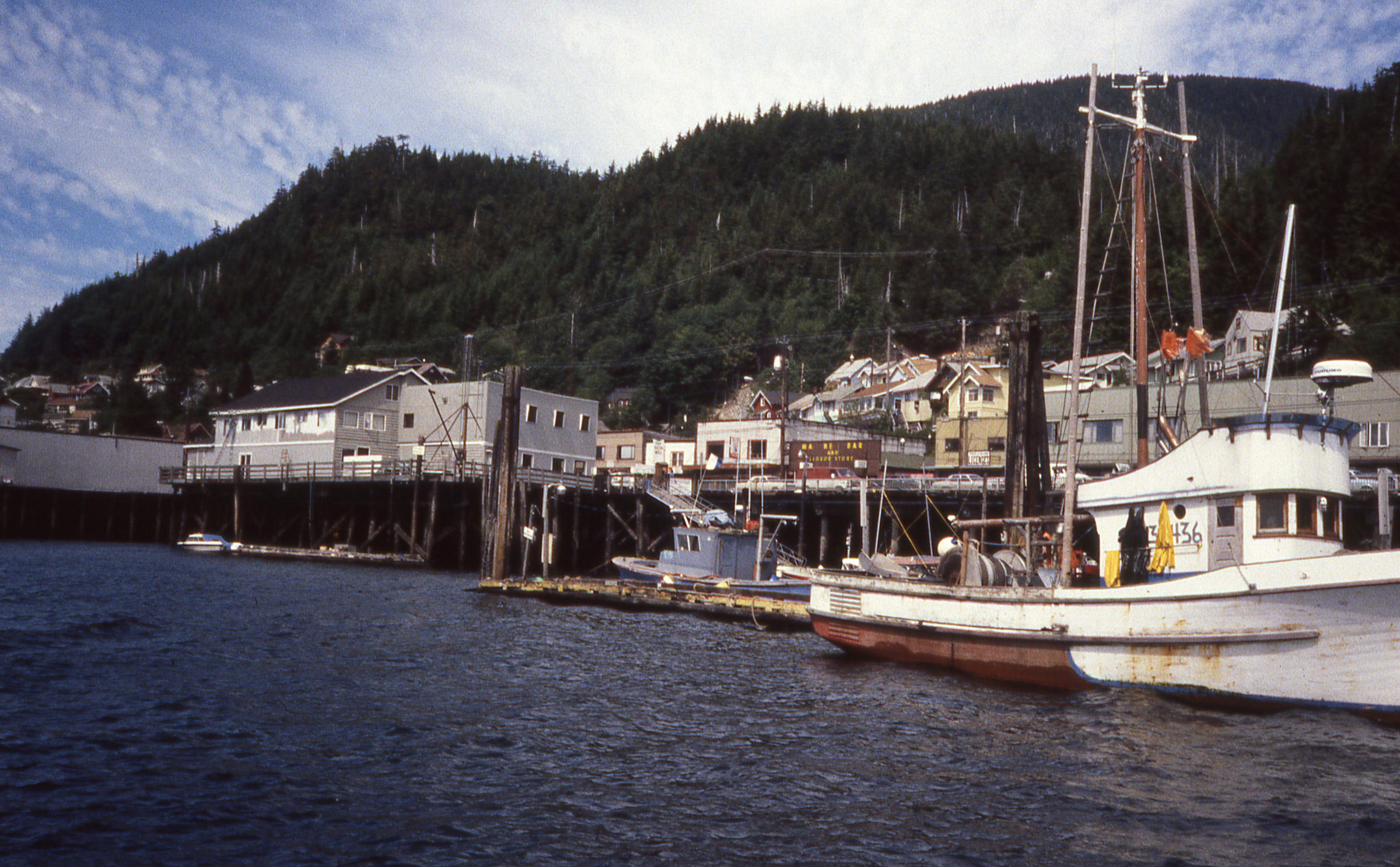
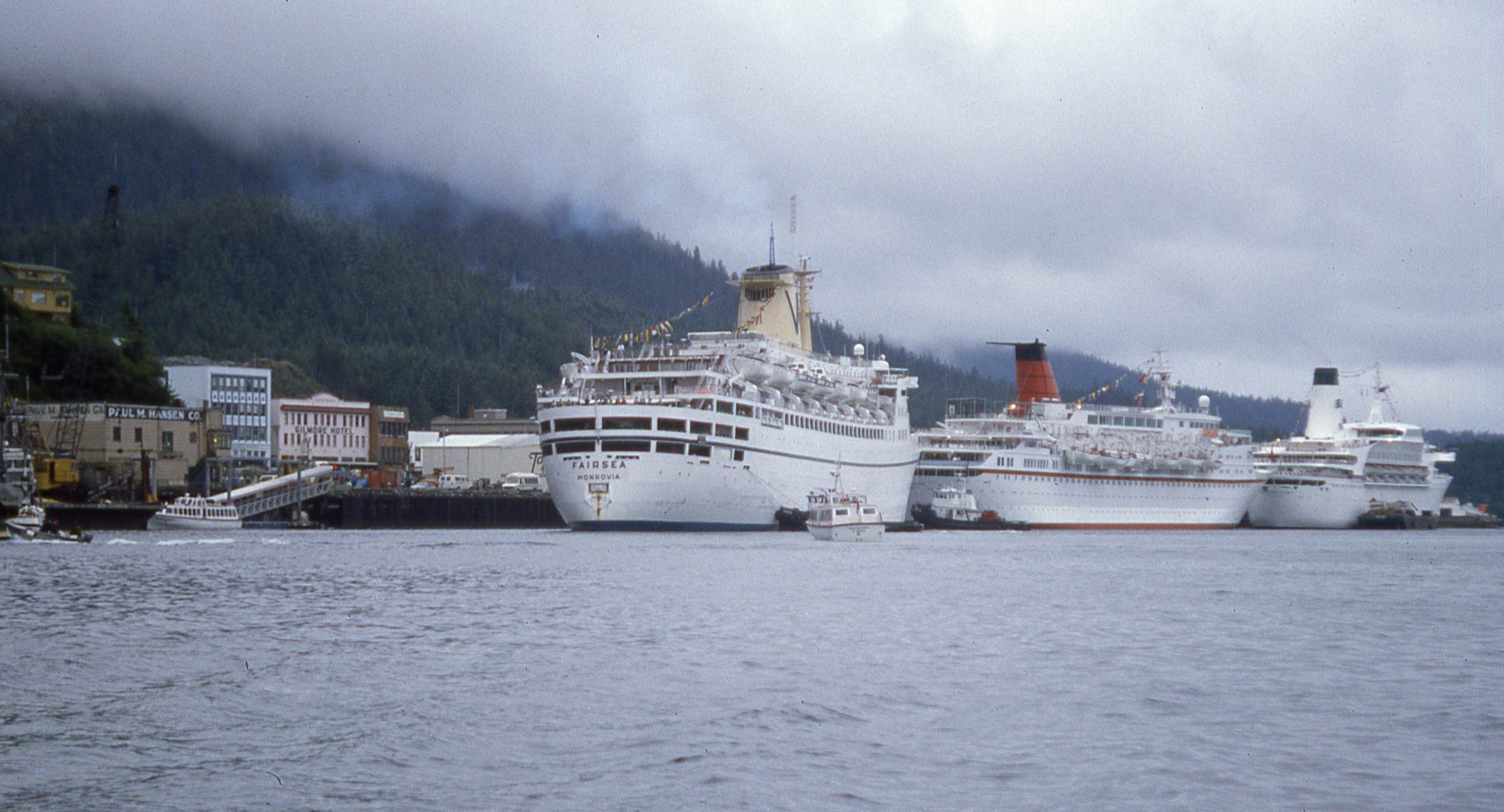
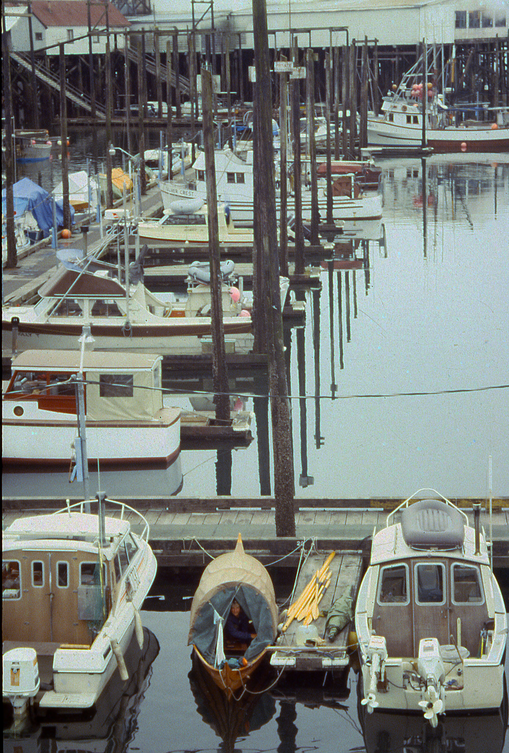
Ketchikan was a nice, quiet town when we arrived.
We arrived at Ketchikan, rowed past the 180′ buoy tender PLANETREE at the Coast Guard station, and pulled in at the first marina we came to. Cindy stayed with the boat while I trotted into town to check in with customs. The agent queried me about my vessel and crew and asked, “Did you have any repairs made while in B.C.?” I told him I’d had a root canal during a stop in Nanaimo.
On my way back to the boat I ran into Tony and Betty, a couple we’d been seeing regularly in ports and anchorages since we first met in Butedale. Their cruising trawler SPIRIT was, of course, much faster than ROWENA, but they stayed longer in the places they visited. They told me they’d be happy to have us spend the night aboard SPIRIT and then went off to arrange for reporters from the local newspaper to interview us that afternoon back at ROWENA.
The following morning we woke aboard SPIRIT, ate breakfast with Tony and Betty, and then Cindy and I walked into town to mail some postcards. Three cruise ships had recently arrived and passengers were flooding into town. The streets were suddenly teeming with throngs of camera-toting tourists. We quickly retreated to ROWENA and cast off.
When we left Ketchikan it was quite crowded. Hundreds poured out of the three cruise ships and the streets were suddenly packed elbow to elbow with tourists.
We rowed north along Tongass Narrows past the row of cruise ships; a woman standing on a dock just to the north of them was waving a newspaper at us. She’d read about us in the morning paper and offered to give her copy to us. The tide was carrying us too fast to get over to her so we could only wave back and shout back our apologies for not stopping. A chop picked up in mid channel so we headed toward smoother water along shore. A man in a T-shirt painting a house rust red yelled, “North to Alaska, wahoo!” A few hundred yards farther along a man stepped out of a house holding up three cans of 7-Up and yelled “Can you use these?” For that we made a U-turn and pulled ashore.
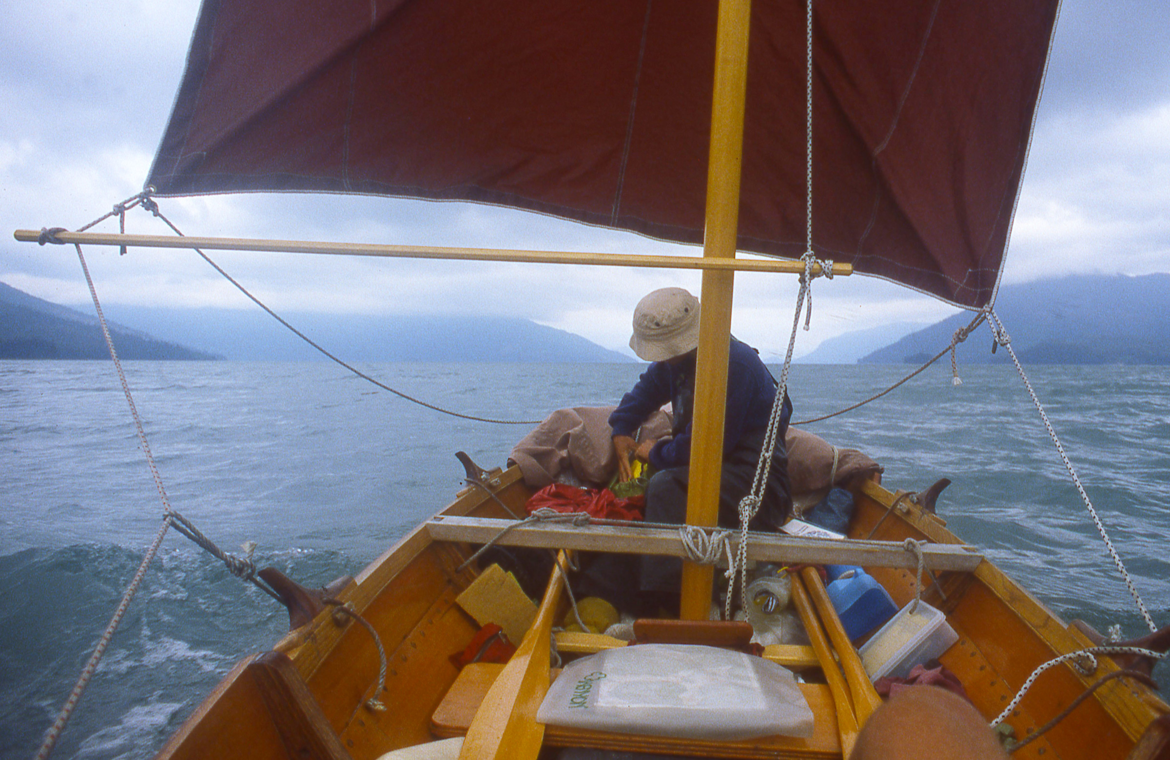
After leaving Ketchikan, we sailed north along Clarence Strait, a 4-mile wide passage between the mainland and Prince of Wales Island. While I’d made the traditional side-hung rudder for the faering, it was easier to steer with an oar. The rudder tended to loosen the ropes that held it in place and the transverse tiller, which would be behind me, was awkward to hold.
The side-hung rudder meant for the Gokstad faering creates a bit of drag that would turn the boat to starboard if not for the blade’s asymmetrical cross section, which creates a bit of port-turning lift. The rudder was effective, but because we frequently switched between sailing and rowing, we rarely used it.
Tongass Narrows dropped us in Clarence Strait where we picked up a strong wind out of the southwest. We set the square sail and reached crossed the 6-mile-wide mouth of Behm Canal. The sail occasionally got backwinded and when it popped back with a loud whump, Cindy would look at me with eyes open wide. The wind died when we finished the crossing at Caamano Point, so we dropped the sail and rowed for a while along the mainland side of Clarence Strait. When the wind picked up, from the south this time, we set sail again. The following seas built quickly and we were soon surfing at speeds we hadn’t experienced before. We could ease the sheets to keep from being overpowered, but that did nothing to reduce the sail area aloft and if the bow veered, the sail, stretched wide along the yard, would pull at the masthead and roll a rail uncomfortably close to the water. We dropped the sail, rolled it up around its yard and tucked it out of the way.
On our way to Meyers Chuck we had a fresh following breeze, too much wind for the square sail, so we set the tarp as a spinnaker. The photo was taken by some friends we made along the way who were traveling north in a cruising trawler. Many of the motor cruisers tended to stay for long periods in anchorages and harbors, so we regularly caught up with them.
Cindy threaded the halyard through the webbing loops on one end of our nylon tarp and tied sheets on the opposite corners. As a makeshift spinnaker it provided all the power we needed, and with the sail area down low we had a much more comfortable ride. The southerly carried us about 19 miles to Meyers Chuck. Cindy was at the helm as we sailed into the cove there, skimming over shoals at the entry in less than 2′ of water.
We spent the night at Meyers Chuck and woke to a thick fog. With time on our hands, we rowed into town, if a store and a post office that serve a few dozen residents could be called that. We stocked up on cookies and gingerbread, and rowed along the shore where most of the houses were perched on pilings either above the water or on the steep rocky slopes. It was past noon when the fog lifted; we rowed 2 miles along Clarence Strait, turned east into Ernest Sound and followed the ragged south shore of Etolin Island to Canoe Pass. The 9-mile-long channel between Etolin and Brownson Island funneled down from nearly a mile wide at its mouth to less than 80 yards in its northern third.
We enjoyed being in well protected water with the shoreline close by to make the scenery interesting, but horse flies found us and made a nuisance of themselves. They were a big as pinto beans and had a painful bite. We couldn’t outrun them so we had to fight back. I’d wave them off my arms and neck, but used the tops of my thighs as bait. I’d let them settle and prepare to cut into my skin and then sneak a hand up from the side and smack them from behind. Between the two of us, Cindy and I had 16 kills. We flicked the bodies overboard.
We anchored at the north end of Canoe Pass and on our second day rowing along Etolin, the skies cleared early in the day and the sun beat down on us. There wasn’t a breath of wind to cool us and the rowing was miserably hot. We found a small cove guarded by an islet at its mouth and fed with a small stream at its back. We filled our black water bag with fresh water for rinsing off, dropped anchor in the middle of the cove, and slipped over the side for a swim.
On an oppressively hot day of rowing around the east coast of Etolin Island, we ducked into a little cove for a refreshing swim and an opportunity to inspect the faering’s bottom.
After around 800 miles of cruising, ROWENA was in very good shape. We had taken great care whenever we brought the faering ashore and the varnished hull was still undamaged.
The varnish was in good shape but I was surprised to see that barnacles had made their homes in the decorative grooves on the plank edges.
I dove under ROWENA and noticed that barnacles were growing on the varnish below the waterline. They were tiny and easy to scrape off with my thumbnail. Back aboard the boat we rinsed with warm fresh water, pumped the bilge out, and left the cove to continue north to an overnight stop in Whaletail Cove.
Two powerboats came into Whaletail Cove after us, checked some crab traps, and left as quickly as they came. We had the cove to ourselves for the night.
We put an early end to the day’s rowing and settled in for a quiet evening and night in the cove.
We got a fast, if brief, ride north from Whaletail with wind and tide in our favor. We sailed 8 miles before the wind died and we had to row the last 12 miles to Wrangell.
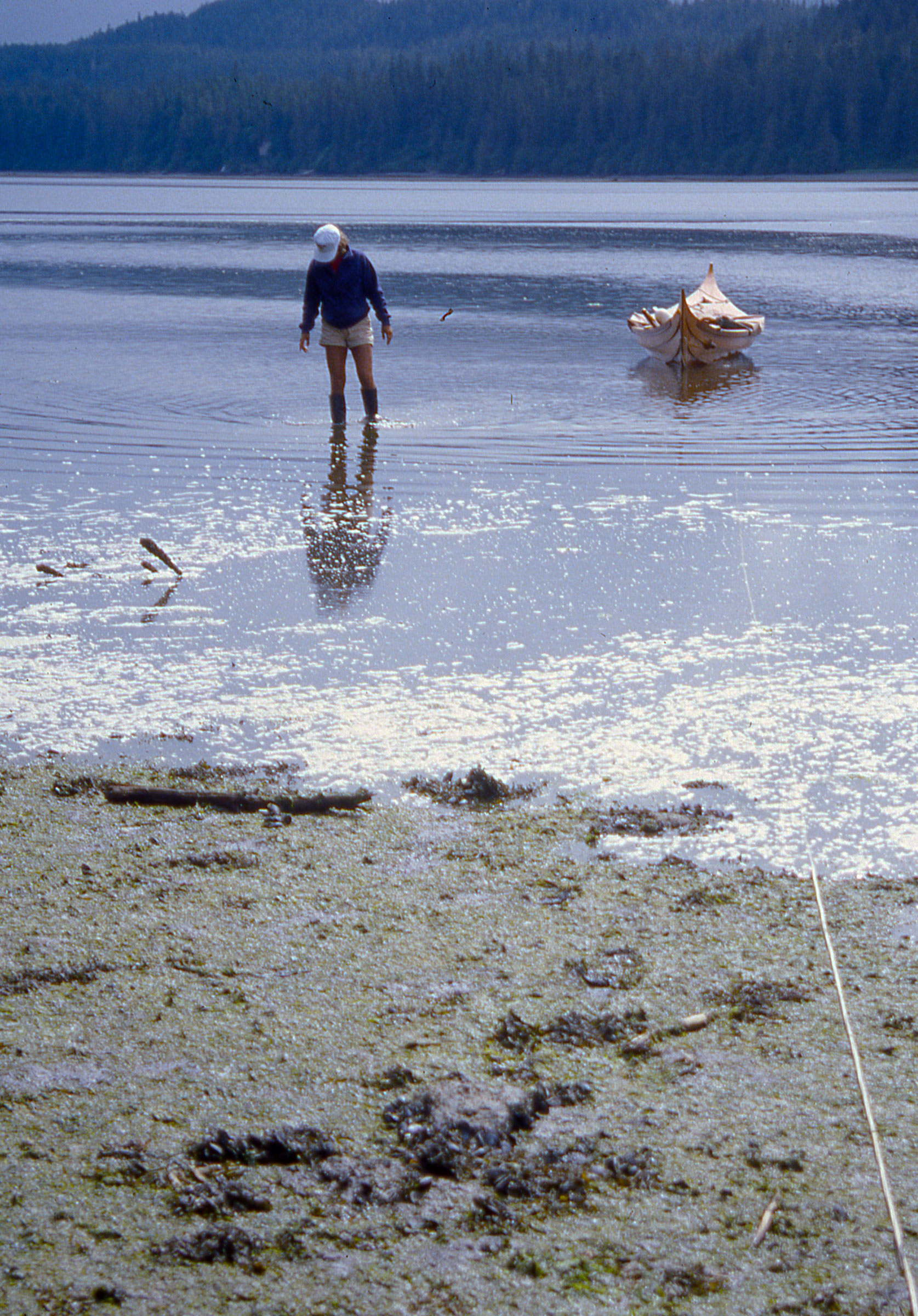
After a stop for pizza and an overnight stay in Wrangell, we headed for the islands at the mouth of the Stikine River. We had been warned to avoid the broad mudflats that surrounded the islands, but the mud turned out to be more entertaining than hazardous. We had arrived on a rising tide, so we wouldn’t get stranded, and the mud was firm enough to support our weight when we stepped out of the boat. The thin layer of creamy fine mud on top was slick as grease. Barefoot, I could dig my toes in and run, and when I got up some speed I could jump, land on both feet and slide for about 20 yards. It was like skim boarding but without the board.
The silt deposited by the Stikine River was quite fine and and slippery, but wasn’t so soft that we couldn’t get out of the boat to stretch our legs.
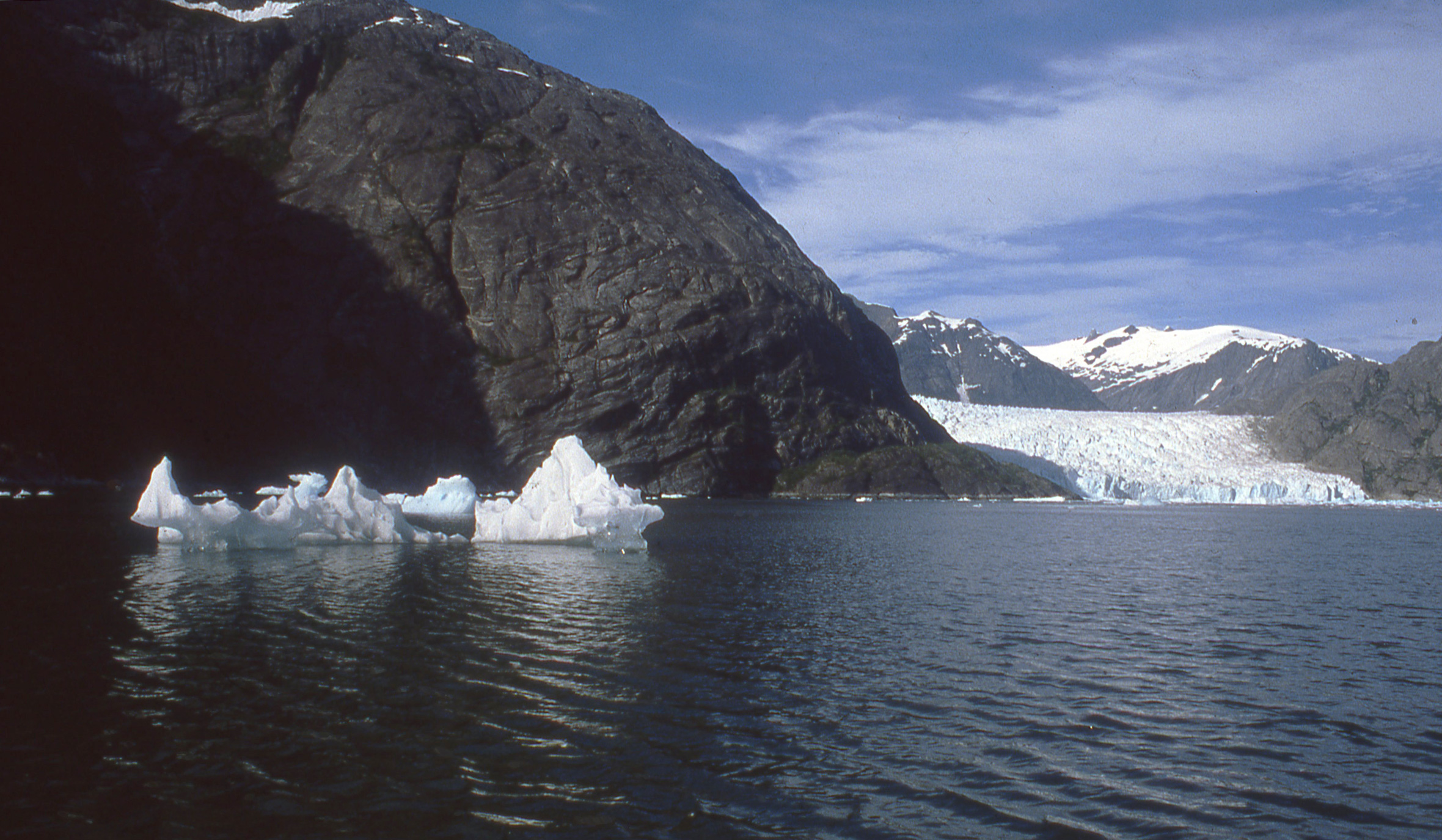
We didn’t stay long because we were eager to get to LeConte Bay where we expected to find a glacier and icebergs. The mouth of the bay was five miles away and while we didn’t see any ice when we arrived there, we could feel the river of cold air flowing out between the banks. A mile in, we found icebergs, and they grew more numerous as we went farther in; the flood tide had been pushed them all back toward the glacier.
The glacier gave the inlet its own climate, cold and windy, while the weather elsewhere was warm and calm. The front of the glacier was about a mile wide and booming now and then as the ice cracked. In the years following our visit, Le Conte glacier retreated a mile from where is it here.
The bay followed a serpentine path and we didn’t get a view of the glacier itself until we were five miles in. At that point we were surrounded by ‘bergs, none of them much bigger than the boat, and most of them nearly transparent, having been melting in the sun. Closer to the glacier they were much larger, white and streaked with a Windex-like blue. One of the larger ‘bergs broke apart and the sound of the ice fracturing and the water pouring off it as it rolled echoed across the bay. The flow of cold air was kicking up a chop and was strong enough that we set sail and let it push us back out to Frederick Sound. The sun had dropped behind the mountain range that surrounded us and the shadow that swept across the ‘bergs and the glacier robbed them of their color, turning them a dusty gray. The tide had turned and many of the icebergs were now drifting out in the Sound.
The cold air sliding down the slope of the glacier created a sailing breeze on our way out of LeConte Bay.
It was late in the day and we needed to find a place to spend the night. We dropped the anchor in a small cove just to the north of the entrance to LeConte Bay. As Cindy got the stove out and started dinner—miso soup with potatoes, carrots, and cabbage—an iceberg a bit larger than ROWENA drifted by just 15′ away and came to a stop. It had grounded itself and now the tide that had carried it here was swirling around it. I pulled the anchor up and rowed us closer to shore. The ‘berg broke in half and the two pieces followed us. We had to leave.
Cindy kept cooking as I began the 7-mile row across Frederick Sound. We ate along the way and then rowed together in the dark under a moonless overcast sky for the last couple of miles. At Mitkof Island we entered a half-mile wide bay, more open than any place else we’d anchored, but it would have to do. I sounded with the anchor until I found about 20′ of water and then set it.
We had ideal conditions on Frederick Sound for our morning row to Petersburg. We could see Devils Thumb, a distinctive spire beyond the Alaska Coast Range and just across the border in Canada. The aptly named Thumb is visible here in the distance, just to the right of center.
When we stopped in Petersburg the harbormaster didn’t charge us for moorage because we had no motor. It rained all night but we were quite dry under the canopy.
After a 15-mile row to the north end of Mitkof, we took a day off in Petersburg before rowing north to Farragut Bay. We’d rowed 25 miles to get there and fought against a strong flood tide for much of the day, working the back eddies when we could, and making several sprints around points where rowing flat-out gained only a few inches per stroke. We arrived at Farragut tired. By the time we found an anchorage on the east side of Read Island, a two-mile long wooded island that lies just inside the mouth of the Bay, it was raining, and then we were tired and wet.
Crossing Farragut Bay in the fog kept us on alert, listening for fishing boats and looking for land.
We were enveloped in fog the next morning. We decided to row the 3-1/2 miles across the mouth the bay and set our course to err on the side of making land inside the bay rather than straying out into Frederick Sound. We had rowed for a long time in the murk and I was just beginning to get worried when we saw the dark shadow of land ahead. We turned south and followed the shore for 12 miles until we reached Cape Fanshaw. There fog lifted and we rowed another 4 miles and stopped for the night in a cove behind Whitney Island.
This little cove would have been the most beautiful and comfortable campsite of the entire trip, but we arrived in a flat calm that offered a quick, safe transit of Stephens Passage.
Our plan for the following day was to get in position to make the 8- to 10-mile crossing of Stephens Passage to Admiralty Island. We rowed north about 15 miles and found a cove that would put us in good position for an early start the next day. The white gravel beach allowed us to pull ROWENA ashore; the spruce trees surrounding it were draped with Spanish moss, there was a flat mossy place for the tent, there were no bugs—it was the best camp site we had found in Alaska. But Stephens Passage was glassy and absolutely windless. We looked north and south and there wasn’t so much as a cat’s paw anywhere.
Unusually calm conditions gave us an opportunity to make a quick afternoon crossing to Admiralty Island.
It was 5:20 p.m.; we’d be across in a couple of hours with daylight to spare. We shoved off and made a beeline for the south end of the Glass Peninsula, settling into a fast, steady pace. Even moving at a good clip, ROWENA hardly left a wake behind us. We made the crossing in 1 hour and 40 minutes. We rowed another 3 miles north along the west side of the peninsula and anchored in Blackjack Cove. The following day we rowed and sailed 24 miles up Seymour Canal to Pack Creek where we hoped to meet Stan Price, the man we’d heard about who lived with grizzly bears.
A fair wind gave us a chance to relax as we headed north up the 40-mile long Seymour Canal. The tiller extension and an oar serve as whisker poles to get the most out of the sail. My waterproof camera, strapped to a raft of inflatable fenders, snapped this picture with its timer.
Cindy took advantage of sailing up Seymour and napped in the shade of the main; I busied myself with raising more sail when the wind weakened.
We landed at Pack Creek that afternoon and found Stan at home in a shore-side cabin he’d built on a raft of logs to float it during especially high tides. He invited us in and Cindy took a chair by the door and I sat at his table. The walls were wide planks of rough-sawn lumber, the gaps stuffed with tissue paper and wrappers to keep breezes out.
Stan built his home on a log raft that floated at high tide in the backwaters adjacent to Pack Creek. Stan died in 1989 and little remains of his home. The area is now the Stan Price State Wildlife Sanctuary.
Stan was 87 years old but still had a full head of hair, bright eyes, and a quick smile. We asked about the danger of the brown bears that we had seen feeding on salmon in the creek. He said they had plenty of food and posed no threat to people. He added that might might attract some unwanted attention from the bears if we’d been cooking over a campfire and walking around, “smelling like a Big Mac.”
Stan Price was 87 years old when we visited him and he had been living at Pack Creek for 42 years. He told us about working in his younger years in the silver mines in Virginia City, Nevada, where the camp cook served antelope meat for breakfast, lunch, and dinner.
We had been chatting with Stan for about an hour and a half when an enormous brown head poked through the door right at Cindy’s shoulder, then turned to look at me, sweeping its snout right over her lap. Cindy froze, eyes wide; Stan grinned and said, “That’s Lucy.”
Lucy, the bear who had poked her head in while we were visiting Stan, took a dip in the rising waters by his cabin. She was probably looking for salmon.
We spent the night at nearby Windfall Island and in the morning rowed under a cloudy sky past Swan Island. We rounded its northern end and the skies cleared as we entered the upper reaches of Seymour Canal. The air was still and warm and the water serenely still. To the east, cottony cumulous clouds rose above the mainland; the steep, thickly wooded hills to the north and west of us were edged with grey bands of bare rock at the water’s edge.
A break in the weather made for very pleasant rowing as we headed north from Pack Creek. Here in the middle of Seymour Canal I used the mast as a floating monopod for the camera.
We didn’t have many photos of ourselves rowing, and the setting deserved to be preserved on film. I had a camera equipped with radio-controlled shutter, so I just needed a place to put my camera in the middle of the canal. I tied the anchor chain to the top of the mast and slipped both carefully over the side. The mast had just enough buoyancy to support the weight of the chain and float vertically with its heel about 4′ above the water. I taped my non-waterproof SLR camera and the attached remote receiver to the mast and Cindy and I rowed around it, triggering the shutter with the transmitter.
The “selfie stick” for the previous photo was ROWENA’s mast with the anchor chain tied to the masthead to get it to float vertically and the rowing rudder lashed at the waterline to keep the camera steadily pointed in one direction. The antenna for the radio-controlled shutter is visible just to the right of the mast.
We had heard about a railway portage across the narrow neck of land that connects the slender, 43-mile long Glass Peninsula to Admiralty Island but didn’t know if it we’d find it in useable condition. It had been built in the 1950s by members of the Juneau Territorial Sportsmen’s association using rails and trams from old gold-mining operations. The latest we’d heard was that it had been rebuilt a few years ago.
As we paddled across the shallows to the mouth of the stream leading to the rail portage, salmon whipped up the still water.
The flood tide pushed us along toward the dead end at the farthest northern reach of the canal. To the west, a 25′-tall waterfall fanned out like a veil over a large rock in the middle of the falls. We were two hours ahead of the high tide and there was a broad expanse of muddy tidal flats separating us from the tall grass that surrounded a creek that we believed led to the portage. I took the anchor rode and two other lines, tied them together and to ROWENA’s painter, and we got out of the boat to wade closer to shore. Our rubber boots stirring up black mud; the air was foul with the odor of decay. I made the line fast to a large rock at the top of the flats and we headed to the creek, crossing a trail of 6″-wide bear-paw prints on our way.
We tried hauling the boat up one creek looking for the portage. I kept an eye out for salmon and gave them time to get out of the way. This turned out to be the wrong creek and we had to back ROWENA back into deeper water.
The first creek we tried was so full of salmon that we had to pick our steps slowly and carefully to avoid stepping on them. Some had made depressions in the gravel, exposing circles of light gray sand. Some of the fish had patches of grey and white on their backs. The dead fish that were completely white. We later found the right creek. It had a cabin about 150 yards from the tide flats and the cart was parked a few yards from the end of the rails, saving us a walk to the other end of the portage to retrieve it.
The rain came down in earnest as we started the first of several trips to get all of our gear to the railhead.
The creek we had to ascend was only a couple of feet wide and half as deep for much of its length, so we wouldn’t be able to float ROWENA up to the rails even at the peak of the high tide. We had to haul all of our gear to the railhead before dragging the lightened faering up the creek.
The direct path from the boat to the railhead was through shoulder-high grass, and we feared we might startle a bear hidden there.
When we got back to the boat to carry the first load, the tide was already up to the rock I’d tied the extended painter to. We coasted ROWENA to the channel leading up to the creek and pulled her up to the edge of the grass and set the anchor upstream. The clouds had been closing in above us, and it had started to drizzle as we were about to make the first carry to the railhead. We put on our rain gear and took the quickest route to the cabin, straight through the shoulder-high grass. We were both nervous about being in bear country near a stream teeming with salmon, walking through grass tall enough to conceal a bear.
We kept ROWENA upright so that only the keel came in contact with the rocks. Its ironbark shoe could take the wear and tear.
When we picked up the second load, it began to rain hard and stayed that way for the rest of the hauls. With ROWENA empty, we dragged her to the creek and often skidded her keel across the mast partner and a 2×6 we’d brought from the cabin to keep her off the rocks. Salmon thrashed upstream as we approached. We cleared rocks that were tall enough to reach past ROWENA’s keel and scratch her garboard. Those rocks were easy to identify, even underwater, because they had silvery tips where aluminum skiffs had left their marks.
The farther up the creek we got the shallower and narrower it became. Hauling the boat over the grass was often less work.
After the long haul up the shallow creek, we had to lift the faering onto the rail cart.
When we reached the end of the rails, I brought the cart down and we eased ROWENA up on it and leveled her with two large fenders that we found by the cabin. It was about 5:00 p.m. and we didn’t have much daylight, so we quickly piled gear in and around the boat.
With the boat and gear loaded on the cart we could begin the 3/4-mile push to Oliver Inlet.
The cart scooted along nicely on the level stretches of track but the combined weight of the cart, boat, and gear made the uphill stretches hard work.
On level stretches, the cart rolled easily.
The rails took a turn to the right and took us into the woods, then ascended a hill. I pushed the cart uphill until it came to a stop and then put shoulder into it and braced my feet against one of the ties. Cindy chocked the wheels with a piece of 2×6, I took break, and then the two of us shoved the cart to the top of the rise. The effort left us panting and sweating. The rails leveled out across a broad area of muskeg, a patchwork of mossy hummocks and irregular pools of tea-brown water, dotted with crooked head-high trees. The tracks then tilted down toward a small valley and the cart picked up speed. I trotted along behind it, crossed a small trestle bridge and held the cart when it came to a stop on the uphill slope on the other side. When Cindy caught up we pushed it up to the next level stretch.
The longest stretch of rail took us across a soggy muskeg field. The boardwalk between the rails was wet, mossy, and very slippery.
We came to another valley and brought the cart to a stop to check on the tracks ahead. Everything seemed in good shape so we continued, letting the cart coast downhill, trying to keep its speed in check. I was having trouble keeping my footing on the wet planks that were set across the ties as a boardwalk, so I planted shifted to walking on the ties, pushing hard against them to slow the cart. It was no use. The cart continued to pick up speed and I had to choose between risking a broken leg and letting ROWENA fend for herself.
I released my grip and the cart raced ahead of me down the slope toward a second bridge and careened up the other side. As I ran across the bridge I could see the cart slow down and in an instant I realized I had to get to it before it started to roll back toward me or I’d have to jump off the bridge to avoid getting mowed down. I sprinted up the hill and caught the cart just as it came to a stop. I put my shoulder against it, planted my feet on one tie, held on to another with my hands, and waited for Cindy. Together we got the cart up to the top of the rise.
The last stretch of the portage descended a steep slope to Oliver Inlet. While Cindy tends our anchor rode as a belay to back up the cable winch, she waves mosquitoes away from her face.
We reached the north end of the portage where the rails take a turn and a steep drop to Oliver Inlet. A rusty cable winch anchored to a stack of ties was there to ease the cart down to the water. I had my doubts about the winch, so I tied the 110′ anchor rode to the cart and looped it around the end of a railroad a tie so Cindy could use it as a backup belay. As the cart rolled down the slope, I braked with the winch, slowing the descent until Cindy was at the tail end of the rode. I squeezed the brake tight and stopped paying out cable. Cindy walked down to the cart and set the rode up again with a turn around another tie close to the cart. It took us three pitches of the rode to get ROWENA to the end of the tracks. The tide was too low to float the boat off so we had to empty it before sliding it off the cart.
The end of the line brought us down to the tide flats of Oliver Inlet.
The air was thick with mosquitos and we batted them away as we spread a tarp out on the marsh grass and unloaded our gear on it. Cindy found our bug repellent; we slathered our faces and hands with it. We finally slipped ROWENA into the water. Cindy packed our gear while I winched the cart back up to the top of the hill.
It had stopped raining and it was hot and very muggy, but the bugs were so thick that we kept wrapped up in our rain gear.
When we finally took to the oars, a cloud of mosquitos followed us out from shore. There wasn’t a breath of wind, so we sprinted to create a bit of our own then ducked down to let the air sweep over us. We sprinted and ducked a half dozen times until we had left the swarm behind.
In the last of the daylight we sprinted away from the portage to escape the mosquitoes.
It had stopped raining, but the still air was thick with humidity, and we were drenched with sweat. We dropped the anchor in a small cove on the east side of the inlet, raised the canopy and made the cockpit ready for a late dinner of beef stew, couscous, and hummus. By the time we turned in it was 10:30, a very late night for us.
In the morning there were mosquitos all over the inside of the canopy; I smeared them with my thumb into the weave of the fabric while I waited for Cindy to wake up. We put the cockpit in order, took the canopy down, and did another sprint-and-duck session to leave the new crop of bugs behind.
We reached the mouth of Oliver inlet and could see a fog-aproned Douglas Island a little over 3 miles away across Stephens Passage. The sky was bright white with a high overcast; both air and water were still, perfect for the crossing. We took the shortest route across and by the time we reached Douglas, the fog had lifted. We rowed east to loop around the southern tip of the island into Gastineau Channel. Two fishing boats were on their way out of the channel and took a course that would take them across our bow. I was annoyed that we’d have to get tossed about by their steep wake, but then both turned to go astern of us. As they passed,a blond man at the helm of the second boat called out, “Chris, is that you?”
“Paul?” I replied. It was a friend of mine from Seattle. He brought his boat SUPREME, alongside. Apparently one of his deck hands had spotted us and reported to Paul that he’d seen “two Indians in a war canoe.” The two boats had altered course to take a closer look.
Paul Enquist, a friend from Seattle and an oarsman coached by my father, found us crossing Stephens Passage on our way to Juneau.
Paul had his cook bring up raspberry Danish and apples from the galley. We said our goodbyes and SUPREME motored off while we took turns eating our unexpected breakfast. Even with just one of us at the oars we made good progress along the steep brush-covered flanks of Douglas Island, streaked white with waterfalls.
Eight miles of Gastineau Channel were all that separated us from Juneau. SOBRE LAS OLAS, a 1929 motoryacht we crossed paths with weeks earlier, came up astern and when she was abeam a half mile to the east of us gave two blasts of her horn; the echoes bounced off the walls of the channel.
Our summer aboard ROWENA put us in good shape and in good spirits.
We reached Juneau in 54 days, having covered over 1000 miles, mostly by oar, a fair bit under sail, and a tiny stretch by railroad. Cindy and I returned to Seattle from Juneau aboard an Alaska State ferry with ROWENA riding on the car deck tucked under a semi’s trailer.
ROWENA took a well-deserved break in the lobby of a bank serving the largely Scandinavian community of Ballard, a neighborhood in northwest Seattle.
We sold the boat to my father to help finance a move to Washington, D.C., where Cindy had won an internship at the Library of Congress; I found work at the Smithsonian Institution. We later moved back to Seattle when I was offered the editorship of Sea Kayaker magazine. ROWENA was purchased by a family friend in Douglas, Alaska, right across Gastineau Channel from Juneau, and was shipped north again. Cindy and I raised a son and a daughter and went our separate ways in 2000. ROWENA’s owner moved to the Seattle area and the boat took yet another ride along the Inside Passage. The Gokstad faering proved itself to be a good sea boat and remains the most beautiful small boat I’ve ever seen.
Christopher Cunningham is the editor of Small Boats Monthly.
If you have an interesting story to tell about your adventures with a small wooden boat, please email us a brief outline and a few photos.
It was a very gentle bump. I’d been sleeping comfortably at anchor after a long day on the water, but I was wide-awake in an instant. A few seconds later it came again—a firm nudge from below interrupting the soft, easy motion of my boat—and this time WAXWING stopped moving. I was aground. I checked my watch—3:30 in the morning, still an hour and a half to go before low tide.
I was quickly out of my sleeping bag and up at the bow, rolling back the boom tent to make room to work. There was no moon out, and in the pitch dark I tentatively stepped out of the boat, probing for the bottom with a bare foot. I slipped up to my thighs into the bracing, 60-degree water and found firm footing on a sandy bottom. With my weight out of WAXWING she floated again, her keel lifting just above the boulder beneath it. A gentle shove freed her and I hopped back aboard. Standing in the bow, I pulled the anchor rode and chain in as quietly as I could and stowed the anchor at my feet.
I reached under the boom tent, fished out one of my oars, and sculled WAXWING in a lazy half circle out to deeper water. The blade slicing through the water stirred up cascades of phosphorescence, which gleamed like fireworks across the inky black water. A dozen yards to starboard, a soft glow penetrated the murk; Rob slid back a corner of his boom tent, and the bright light of his LED lantern appeared. “Everything all right, John?” “No worries,” I called back cheerfully, “We’re just having a little adventure.” When I’m sleeping aboard my boat, being awakened by something that goes bump in the night is never just a good night’s sleep spoiled; it’s an experience.
John Hartmann
WAXWING (top) and SLIPPER, loaded with gear prior to departure, wait at the dock in Herrick Bay, pointing southeast toward the islands that separate Blue Hill Bay and Jericho Bay. Summer mornings here are usually calm; winds develop as the day wears on and the sun warms the land enough to generate on onshore breeze.
Rob and I had started our adventure on the heels of the Small Reach Regatta, a gathering of mostly wooden, mostly owner-built small boats. The fleet had moored in Herrick Bay, a half-mile wide inlet between Flye Point and Naskeag Point near WoodenBoat’s campus in Brooklin, Maine. After the event, he and I had left our boats anchored there for a day of provisioning. Our plan was to circumnavigate Deer Isle under sail and oars.
John Hartmann
The Ilur has a voluminous cockpit with room enough to carry gear for a multi-day trip. The blue duffel holds a bedroll, the green bucket is for bailing and collecting trash, a clear dry bag holds clothes, and the white bucket is the loo. The gray chests with red lids are kitchen and larder, the yellow soft cooler is ice chest for cold drinks and fresh foods, and the green cooler holds a five-gallon container of drinking water.
When we returned the next morning, Rob made preparations aboard SLIPPER, his 16′8″ Herreshoff Coquina, and I stowed a small mountain of gear in WAXWING, my 14′8″ yawl-rigged, François Vivier-designed Ilur. I made sure everything was secure and out of the way so I could freely move about in the cockpit, and we shoved off by mid-morning.
The tide would be in our favor until late afternoon; the wind, building out of the east, appeared as little cat’s-paws dancing on the water. The breeze swirled toward us across the bay, cooled our sun-warmed faces for a moment, then gamboled away. SLIPPER and WAXWING ghosted along side by side as the dark blue-green water slid lazily past. I got the rig set and shifted my weight to leeward to settle the boat over on its bilge to reduce the hull’s wetted surface and eke out a little more speed. Weaving among and around floating mats and broad bands of bronze-colored seaweed, we stayed well off Flye Point, where I could see, even now just past high tide, the telltale curdling of water washing over the barely submerged mile-long boulder field strewn between the point and Flye Island.
We were covering ground slowly—little more than 1 mph according to my GPS. At this speed, we would likely make it only as far as the east end of the Deer Isle Thorofare before the tides turned against us. Breaking out the oars, I began rowing gently while WAXWING’s big, fully battened, standing-lug mainsail took advantage of the bit of wind we had. With the tide coaxing us along, the combination of sailing and rowing nudged our speed up to almost 3 1/2 mph.
Off the Naskeag Point side of Herrick Bay, a broad-winged osprey vaulted from the top of a tall spruce, sailed out over the water, and pulled up momentarily to hover, eyeing the water before winging away. Rob and I row-sailed for a bit; the wind finally freshened and we shipped our oars.
John Hartmann
As Rob passed the ISAAC H. EVANS in the Deer Isle Thorofare, the schooner was sailing against the tide and getting a motor assist from the yawl boat astern. Built in 1886 for harvesting oysters along the coast of New Jersey, she now works out of Rockland, Maine, and sails the coast as part of the Maine Windjammer fleet.
By noon, we’d crossed the southern end of the Eggemoggin Reach, and rounded Stinson Neck, the southeastern tip of Deer Isle. Our course turned from due south toward southwest as Deer Isle Thorofare opened ahead of us; tide and wind now swept us along as the miles unfolded. From this vantage point, the shoreline of Deer Isle at the eastern end of the Thorofare is corrugated with peninsulas and islets. A sprawling archipelago of small islands between Deer Isle and Isle au Haut studded the steely blue waters as far as we could see.
The Thorofare is a very busy waterway along the southern coast of Deer Isle. As Rob and I sailed along, a group of five large schooners was heading up the passage together, working against the tide with sails set and yawlboats nudging them along. Toward the western end of the Thorofare, we ducked out of the main passage and headed south again, threading our way through numerous islets, nameless shoals, and sand bars on the way to George Head Island, an uninhabited islet scarcely a third of a mile long set in the heart of the archipelago.
John Hartmann
The cove at George Head Island provides a protected anchorage until the tide covers the sand spit leading off to the left to Little George Head Island. Merchant Island and Isle au Haut Bay lie in the distance to the south.
We slipped into the cove on the east end of George Head in late afternoon, a short while before the low tide. A large sandbar extends from the northeast corner of the island, and another curves out from the southeast corner to reach its smaller sibling, Little George Head Island. The bars form a well-protected cove at all but high tide. Now, nearing low slack, both islands were fringed with a broad band of exposed, weed-covered cobble and boulders. In the shelter of the cove, the scent of the exposed intertidal was pungent but pleasant.
We would be sleeping aboard our boats, and with overnight winds expected from the southwest, we decided to anchor on the Stonington side of the northernmost bar, to be in the lee of George Head’s densely wooded eastern shore. By the time Rob and I had set our anchors for the night, it was not long past low tide, so I let out enough extra rode to have adequate scope for the midnight high. As we slept the wind and tide nudged WAXWING over a large boulder in the small hours of the morning, and the rippled sea and ebbing tide soon had it bumping against her hull.
John Hartmann
With the boom tent up and after thwart stowed, WAXWING is ready for the night. The boom tent is a minimalist affair, very wind- and rain-resistant, but open at its ends. If protection from insects is needed, a 4’ x 6’ foot piece of no-see-um netting draped over the sleeper’s head is put to use.
Once WAXWING was safely anchored in deeper water, I settled down to try to get another hour or two of sleep, but it was nearly 4 a.m., and the fleet of lobsterboats that operates out of Stonington hustled toward the 50-yard-wide channel between the George Head bar and St. Helena Island. I could hear the roar of the big diesel engines even as the boats powered out of Stonington Harbor, and the din reverberated through the cluster of small rocky islands around us. The fleet approached and funneled through the gap only a couple of hundred yards from us. After the first few thundered past, I gave up on the idea of any more shuteye, and stowed my bedroll just as day was beginning to break.
John Hartmann
While SLIPPER and WAXWING were rafted up for breakfast, the low tide uncovered the boulder garden on the north side of George Head Island. One of the boulders in the area knocked against WAXWING’s bottom in the middle of the night, requiring a bit of wading to get her over deep water.
Rob was up too, so I hauled anchor, sculled over to his boat, and rafted up for breakfast. I dug out my old brass Svea stove, an ancient and trustworthy traveling companion, along with my Bialetti espresso pot. The yellow flames from the fuel I’d dribbled into the primer hollow at the base of the stove flickered up and before long the little stove’s blue flame was making a roar of its own, Lilliputian compared to the big lobsterboats, but much more welcome. Breakfast was homemade granola, fresh Maine blueberries, and a piping-hot latte. Although Rob tends toward minimalist camping and frugal dining, no doubt habits fostered by years of sea kayaking, I sail a type of boat that was once meant to carry fishermen and a boat full of fish safely back to port every night. She is a weatherly little packhorse, and I happily take advantage of her capacity, routinely stuffing her with provisions enough to take care of three or four sailors on outings of as many days. Rob cheerfully tolerates my sybaritic tendencies, and made no objection to the foamed latte as I handed it across.
WAXWING and SLIPPER bobbed gently in the cove as the rising sun sent spears of gold up through breaks in the clouds. The water was glassy calm, and the dawn reflected in a great shimmering column of light. I was sleep-deprived and salt-crusted, but this was still heaven on earth. Arctic terns cried, wheeled, hovered, and dove along the bar. One hungry bird splashed down less than a dozen feet from us, then surfaced and wheeled away with a wriggling 3″ sand eel dangling from its orange beak.
Sipping our coffee, we listened to the weather forecast, looked over our charts, and considered the tides as we discussed the day ahead. We’d have light and variable morning winds, and afternoon winds to 10 mph. Low tide was fast approaching; our intended destination would be Butter Island, 11 miles up East Penobscot Bay. If we waited till midday, there would be wind for reaching, but we’d also lose a favorable tide, and progress would be iffy. We separated the boats, Rob weighed anchor, and we set out rowing north-northwest.
East Penobscot Bay was dead calm, disturbed only by the eddies swirling off the tips of our oars. Striking out into the wider waters between Deer Isle and North Haven Island, we made our course toward Eagle, Butter, and Great Spruce Head, a trio of mile-long islands in the middle of a cluster of smaller islands near the top of the bay. It was still early, and except for a few lobsterboats rumbling off in the distance, we had the eastern bay to ourselves.
After a bit of rowing, Rob and I were well offshore, but not entirely alone. A succession of seals followed us for about a minute at a time, staying 20 or 30 yards off our sterns, with their great, dark eyes fixed on us.
John Hartmann
For the long row north to Eagle Island, Penobscot Bay was glassy calm.
Rob and I took a break, put on sunscreen, and snacked on granola bars and fruit. The tide carried us up the Bay and past the tip of Eagle Island. The water was glassy smooth from Deer Isle 2-1/2 miles to the northeast, the same distance to North Haven in the southwest. Over WAXWING’s transom, the sky met the open Atlantic beyond Isle au Haut Bay. We took to the oars again, pulled for Butter Island, and by late morning came ashore on the broad crescent of Nubble Beach on its eastern shore just before high tide.
We had the whole afternoon ahead of us, so we put the boats at anchor to keep them afloat through the falling tide cycle, and set off to explore the island. It is a mile long and a half mile wide, its shoreline scalloped with beaches. We walked a trail through shaded woods to the 150′-high summit of Montserrat Hill, where we could see the upper end of Eggemoggin Reach 7 miles to the north, and the undulating ridgeline of the Camden Hills 15 miles to the west across West Penobscot Bay. There is a polished granite bench at the summit, a memorial to Thomas Cabot who bought Butter Island in the 1940s to preserve it for the people of Maine. Engraved on its thick curved edge is a line for Tennyson’s poem “Ulysses”: “Come, my friends, ‘tis not too late to seek a newer world.” From the bench we had a clear view down to the beach, where SLIPPER and WAXWING were riding quietly at their shared mooring, with plenty of water beneath them in the receding tide. A schooner worked its way up the East Penobscot Bay, and thunderheads piled up over the mainland.
John Hartmann
The view from Montserrat Hill took in WAXWING and SLIPPER anchored next to The Nubble, a rock outcropping at the easternmost point of Butter Island. Tides are commonly 10′ to 12′ along this part of the Maine coast. The boats are on a modified Pythagorean mooring to keep them afloat and off the beach, but easily retrievable.
We made our way back to the beach; it had been a full day, and we turned in after an early supper for a sound sleep anchored off Nubble Beach.
Following breakfast the next morning, we set out north-northwest, rowing in the calm until we were about halfway between Bradbury and Pickering islands. The waking winds, coming from the southeast, hinted of a useful breeze. Rob and I set our sails to catch whatever breezes might help us, and then got back to rowing to speed us on our way. Not far off, pods of harbor porpoises surfaced, swimming in ever-tightening circles as they corralled small fish for their morning meal. The sound of their quick breaths carried across the water to us in the stillness of the morning.
John Hartmann
In a light breeze Rob row-sailed toward Pumpkin Island and the top of the Eggemoggin Reach. Sail-assisted rowing made it possible to cover mileage more effectively when sail alone would have been too slow to keep the pair on schedule to make good use of the tidal currents around Penobscot Bay.
We rounded Pumpkin Island, a low islet scarcely large than a football field, skirted in bare granite with a squat cylindrical lighthouse attached to the keeper’s house at its center. At the head of Eggemoggin Reach, the winds steadied, so we stowed the oars and sailed southeast down the Reach toward the suspension bridge that links Little Deer Isle to the mainland. The breeze was now coming from the east-southeast, so we had to work to windward. The winds were still light, and the going was slow. I tacked back and forth below the bridge, looking up at the catenary curves of the main cables, the thick green girders beneath the roadway, and the delicate looking web of criss-crossed suspension cables between them. The tide had come to its high slack about the time I passed under the bridge, tacking back and forth between the Deer Isle causeway on one side, and a red nun on the other.
Rob was five or six hundred yards ahead of me in SLIPPER, and all of a sudden he was away like a rabbit, coursing down the Reach carried by an ebb tide flowing south to Jericho Bay. It dawned on me that where I was sailing the water was flowing north out of the Reach on an outgoing tide. I had not yet passed the tidal watershed! I was barely holding my own, tacking repeatedly from nun to causeway and back again and again. With the wind on my nose, and the strengthening ebb against me, I had no choice but to drop the rig and start rowing—with grim determination. After a half mile the rowing seemed easier, and I could see that the shoreline was slipping by a bit faster. I shipped the oars, hoisted sail, and with more than a little relief I was under way again, now keeping pace with Rob and SLIPPER.
John Hartmann
The Deer Isle bridge, spanning 200’ at a height of 85′ above the water, opened in 1939. It was built to a design similar to Washington’s Tacoma Narrows bridge, which famously collapsed in 1940 due to wind-induced oscillations. The Deer Isle bridge was also damaged by oscillations in strong winds and extensively modified in 1943.
The day was warming up, and the onshore breeze was coming alive; the winds continued to freshen as the afternoon grew hotter. Before long I had to sheet the mizzen in tight, heave to, and tie a reef in the main. Down through the southern end of the Reach, Rob and I had some pretty spirited sailing, and we were both up and down on the rail for the next three or four miles, our two boats punching forward on blue-gray water generously flecked with white caps.
Around the outside of Hog Island at the tip of Naskeag Point, we met the 65′ schooner ISAAC H. EVANS, returning from Mt. Desert Island. With a magnificent spread of canvas driving her, she fairly swept up the Reach, soaring past us with a hiss of water foaming along her sides, a picture of power and grace.
Gabrielle McDermit
With three miles left to go, WAXWING stopped at a sheltered beach on Sellers Island.
Soon we were rounding Devils Head at the end of Hog Island, and broad-reaching for Sellers Island, a wooded islet surrounded by boulders on all but its north side. I could see my wife Gabrielle on the beach, waving. She and our young friend Erika had been aboard WAXWING for the Small Reach Regatta earlier in the week, and today had sailed a small pram the half mile from Naskeag Harbor out to Sellers’s semicircle of white sand, hoping to meet up with us as we left the Reach. Seeing Gabrielle waiting for me on the island’s boulder-studded outer shore made me feel like a 19th-century ship captain returning safe from sea after a long voyage.
Rob and I landed on the beach, and after a break to stretch our legs, Gabrielle joined Rob in SLIPPER, Erika hopped aboard WAXWING, and we took the pram in tow. It was early evening, and the onshore breeze was dying away with the setting of the sun. Gabrielle rowed SLIPPER around the point and up Herrick Bay toward the takeout, but there was still enough wind for WAXWING’s large and powerful rig, so Erika and I hoisted sail, and she skippered WAXWING back to the mooring.
We left the boats anchored and would haul them out the next morning. Rob and I paused at the top of the dock looking back at SLIPPER and WAXWING, both riding quietly at anchor in the last light of the day. There was more to Tennyson’s poem than the line inscribed in the bench atop Montserrat Hill on Butter Island. In another passage he expressed the lure that draws me to explore the coast in a small boat and the touch of sadness I feel at the journey’s end:
I am a part of all I’ve met;
Yet all experience is an arch wherethrough
Gleams that untravelled world whose margin fades
For ever and for ever when I move.
How dull it is to pause, to make an end,
To rust unburnished, not to shine in use!
John Hartmann lives in central Vermont. He built his Ilur dinghy, WAXWING, to sail the 1000 Islands region of the St. Lawrence River, Lake Champlain, and along the coast of Maine. He details the Pythagorean mooring system he used at Nubble beach in the Technique article in this issue.
François Vivier’s Ilur
Christophe Matson
The yawl configuration is one of four options for the Ilur’s sailing rig.
The Ilur is a modern interpretation of the coastal inshore fishing boats that worked the Bay of Biscay in the age of sail and is naval architect François Vivier’s best-selling sail-and-oar design. Many hundreds have been built in Europe. The Ilur was an evolution of an earlier Vivier design, the Aber, with greater length, beam, and freeboard to make her a better choice for work in big water. The Ilur is available as plans and full-size Mylar patterns and as a CNC kit. I bought a kit from Clint Chase of Chase Small Craft, one of Vivier’s partners. The kit uses an egg-crate system of interlocking transverse and longitudinal bulkheads to ensure a rigid building jig. An additional advantage of this construction technique is that once the hull is flipped after planking, most of the interior furniture is already built into the boat. The egg-crate system not only provides a highly accurate building jig, but also yields an enormously strong and stiff hull. There are four different rig options: the boomless standing lug, a balanced lug, a lug sloop, and most recently, a lug yawl. I found the lug yawl an ideal rig for dinghy cruising, as it allows the boat to self tend when heaved to for reefing in open water, or if the skipper needs to go forward for any reason.
—JH
Ilur Particulars:
[table]
LOA/14′8″
LWL/13′5″
Beam/5′7″
Draft, board up/10″
Draft, board down/2′10″
Weight including rig, anchor, and oars/400 lbs (approximate)
Sail area/130–150 sq ft, depending on rig
[/table]
If you have an interesting story to tell about your adventures with a small wooden boat, please email us a brief outline and a few photos.
Subscribe For Full Access
Flipbooks are available to paid subscribers only. Subscribe now or log in for access.
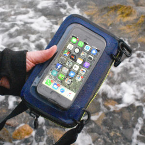
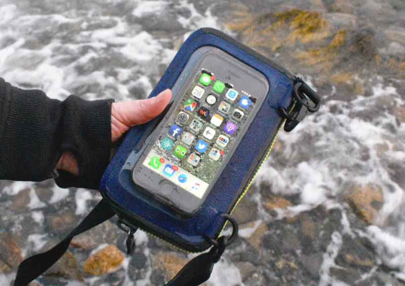 photographs by James Bartick