I set out, boat in tow, well before dawn to get from my home in New Hampshire to Rockland, Maine. John, coming from Vermont, had started his drive even earlier. We needed to be on the water by 10 in the morning to make the crossing of Lower Penobscot Bay and get to the narrow entrance of The Basin on Vinalhaven at slack tide. The forecast looked promising for the 10-nautical-mile crossing. With a wind out of the south at 12 knots, we could make good speed on a broad reach out of Rockland Harbor and across lower Penobscot Bay, a stretch of water that is known for foul weather and steep seas. This was the first challenge to overcome on our trip, which was to be a circumnavigation of North Haven Island, Vinalhaven’s northern sister and the smaller of the two Fox Islands. A few years prior, I had circled Vinalhaven from Rockland with my Sea Pearl and wanted to explore more of the area. John, after hearing about that first trip, was eager to do something like it with me.
 Roger Siebert
.
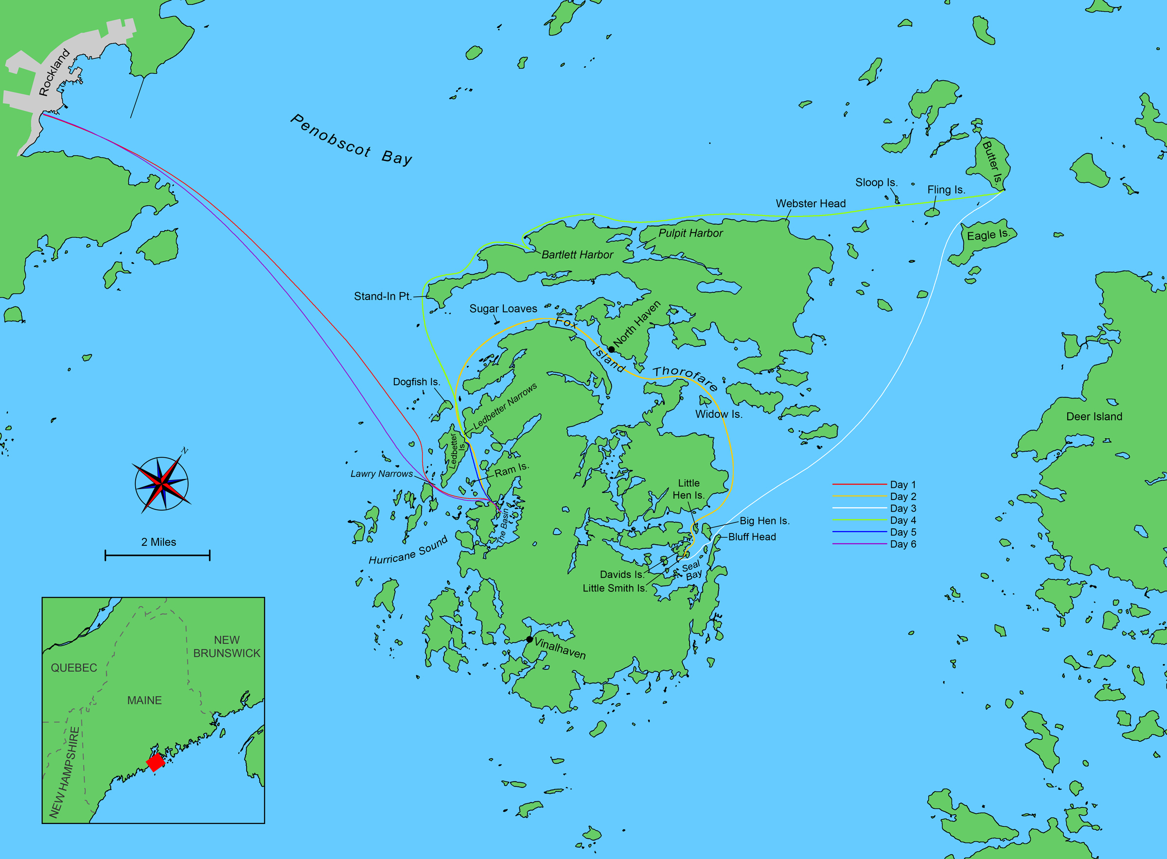
Rockland Harbor, 2 miles wide, didn’t have much wind. Across Penobscot Bay, Vinalhaven was made invisible by fog but for the motionless pearl-white blades of the island’s wind turbines stabbed skyward. Soon after we ghosted off the ramp with a weak southwestern breeze, the peak of John’s mainsail suddenly came undone. Sail and boom came crashing into the boat, and it took another 30 minutes to get sorted out. The current in Penobscot Bay was in a strong flood, flowing northward, and instead of the good sea breeze we expected there was a weak southeasterly wind. A straight shot across to Vinalhaven proved impossible and by the end of the crossing we were pressed to the ragged granite north end of 500-yard-long Dogfish Island, more than a mile and a half north of where we wanted to land with no time-efficient way to sail against the current. We hurriedly struck our rigs and rowed, frantically, the final 2.5 miles.
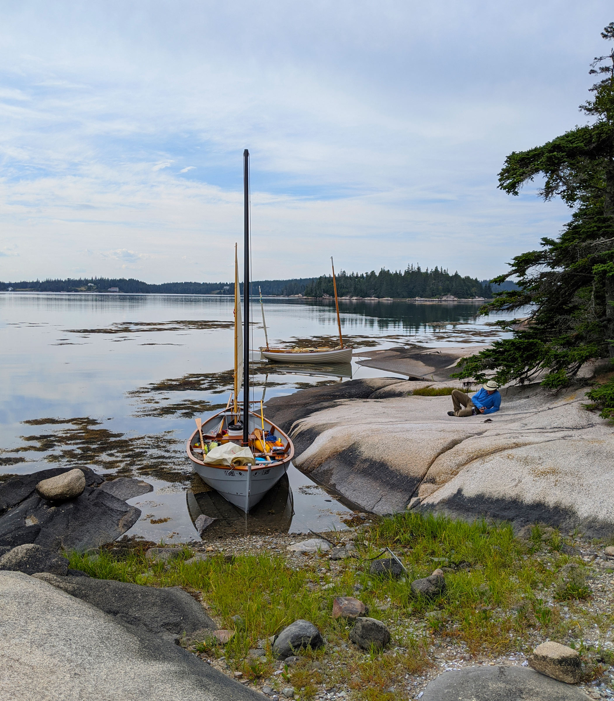
As I rowed around the forested southern point of Ledbetter Island, John, rowing his 14′ lug-yawl-rigged Ilur, WAXWING, was not far behind and just off my starboard quarter. As we pulled into Hurricane Sound I nervously glanced at my watch. The Basin, a 1-1/2-mile-long, forest-lined inland cove, is nearly a saltwater lake but for a current-swept 150’-wide entrance, with a bare bedrock outcrop blocking the middle third. It offers engineless mariners very short windows of slack tide to enter or exit. John and I had about 15 minutes until the top of the tide, and the gates into The Basin were just shy of a nautical mile away. I reckoned my boat, MUSSELS OF DESTINY, a 19’ Caledonia Yawl, was moving at about 2 knots. WAXWING, slightly faster under oars, passed on starboard. Either we rowed into The Basin at slack tide or we would be shut out for the night. Rowing against the swift outflowing current would be impossible.
We pulled closer to the narrow northern entrance channel with the outcrop rising from the water on one side and a 10′-high stone slab looming over the other. I had slammed my Sea Pearl 21 bow-first into that slab during a failed attempt to enter The Basin a few years earlier. I had lost control of the boat against the powerful current which had swept it aside as if it were dust.
As John and I drew near the channel we passed a lone lobster buoy tilted in our favor. The last of the flood tide split around the entrance’s 50′-wide guardian into two streams that would rejoin behind it and then, just 125 yards farther east, split again into two channels around a tree-capped islet—south to the main channel and north to a shallower one. Since it was high tide, I had suggested earlier to John to go south through the wider, more navigable pass around the outcrop, and then north around the islet.
John slowed his rowing tempo and WAXWING smoothly accelerated into the pass; soon MUSSELS was also in the grip of the current and pulled forward, sliding effortlessly past the slick, dark, seaweed-fringed outcrop and around the rocky islet with its few craggy trees.
 Christophe Matson
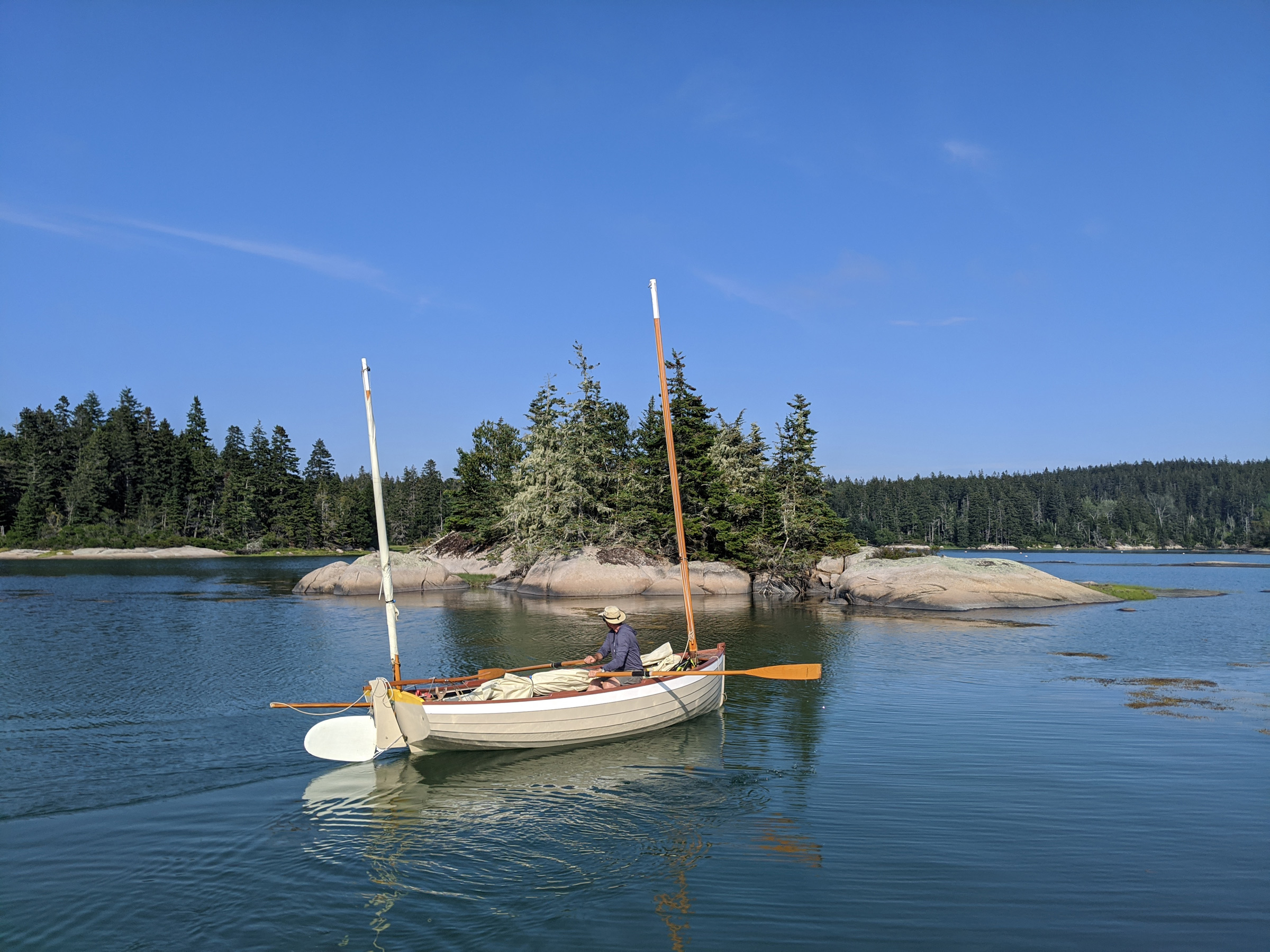
The fog rapidly cleared as we searched for a suitable anchorage in The Basin. It took a day of hard rowing to get to this place, but it was well worth the effort.
In a few moments, we were delivered from the close, damp confines of the entrance and into the expansive flat-calm embrace of the cove. The fog had cleared and sunlight poured onto us. We rowed another third of a mile to the east side of The Basin and dropped our hooks into 40′ of water about three boat-lengths north of an island just 400′ long and wide.
 Christophe Matson
The nearly omnipresent fog rolled back over The Basin while John prepared his dinner in WAXWING. Surrounded by a wooded shoreline and as the only boats in The Basin, we were immersed in silence and total seclusion.
John transformed WAXWING from travel mode to camp mode while I settled onto the floorboards; a new, rapidly approaching bank of fog closed in around us and turned the sun silver as it settled lightly on the spruce tops.
 Christophe Matson
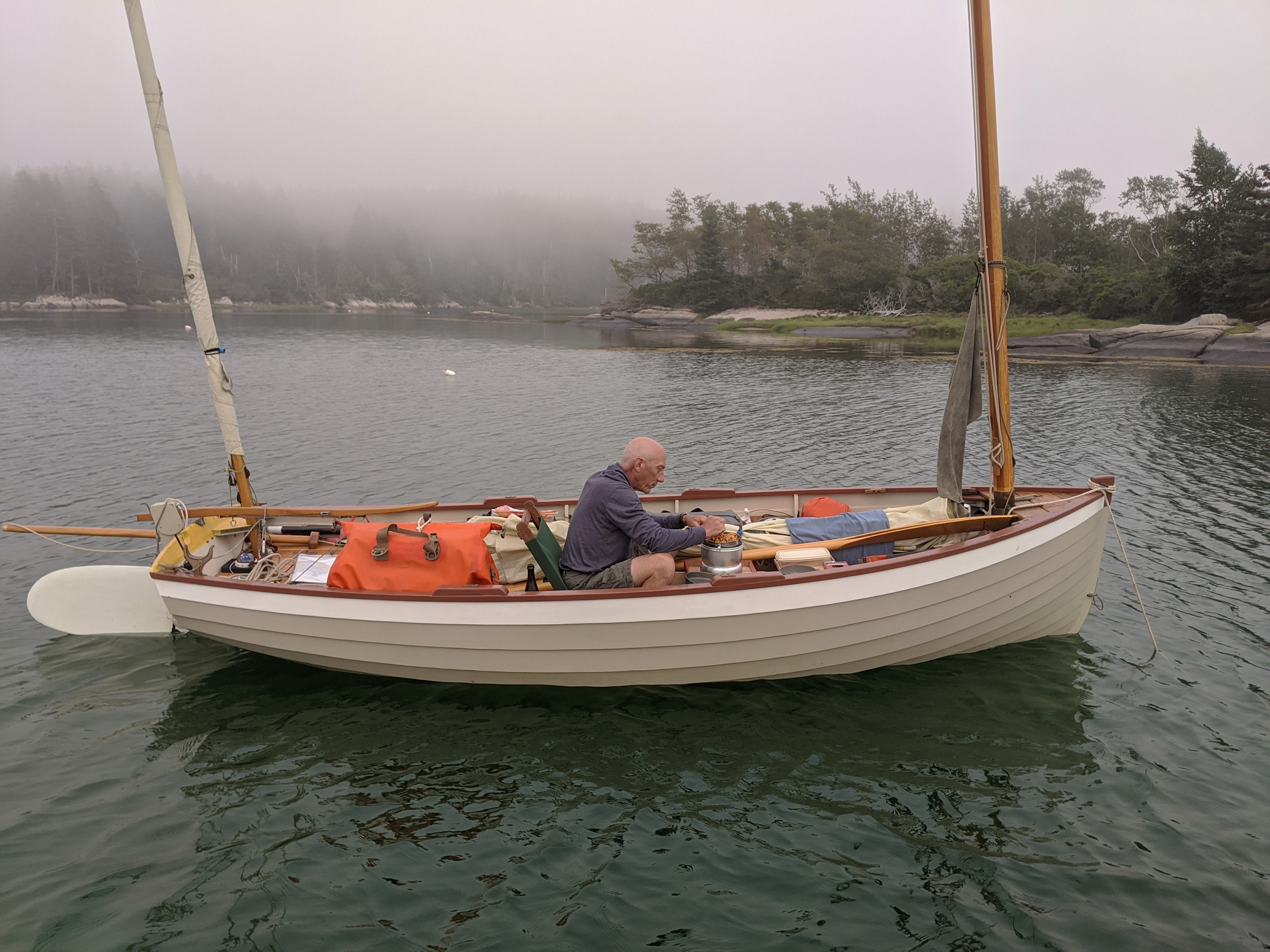
Sunrise on our first morning on the trip and the fog was already thin, a promising start to the day. John still had WAXWING buttoned up with his custom tent.
The next morning, we woke to the fog, which the rising sun rapidly burned off. We waited for the ebb to ride out of The Basin on the current and back into Hurricane Sound. The plan was to then head north, through the tight Ledbetter Narrows on the north end of the island of the same name, and then through Fox Islands Thorofare to the east side of Vinalhaven where we would overnight in Seal Bay.
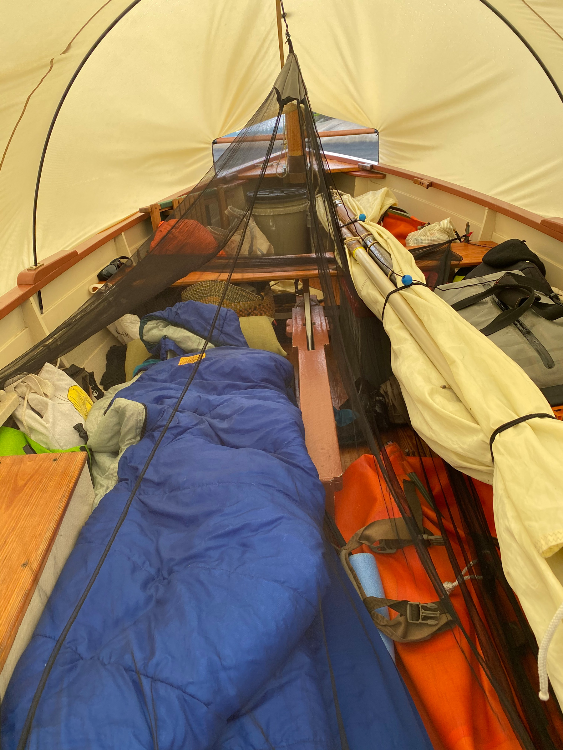 John Hartmann
The interior of WAXWING in camp mode is a crowded yet tidy arrangement with the wet gear and the sail bundle to starboard to keep clear of John’s sleeping quarters to port. A mosquito net helps ensure a good night’s sleep, uninterrupted by bugs.
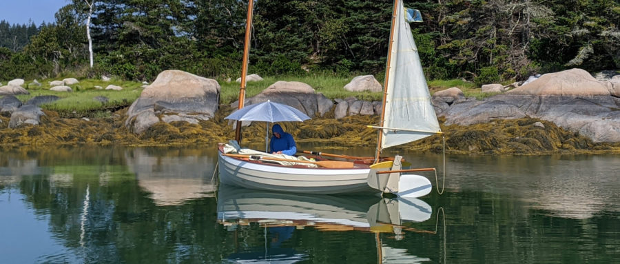
While we waited, I swam around seaweed-draped ledges and dried off in the brilliant sunshine while John puttered about WAXWING under his silver-colored sunshade umbrella. After an hour, the low sound of dashing water cascading out of The Basin faded. We donned our life jackets and rowed around the islet to the exit. We captured the last of the current and calmly zipped downhill out of the cove and back into Hurricane Sound.
 Christophe Matson
The fog burned off as we waited for the tide to go slack so we could exit The Basin and start our circumnavigation of North Haven. John took refuge from UV rays under an easily deployed umbrella; I took advantage of the excellent swimming conditions.
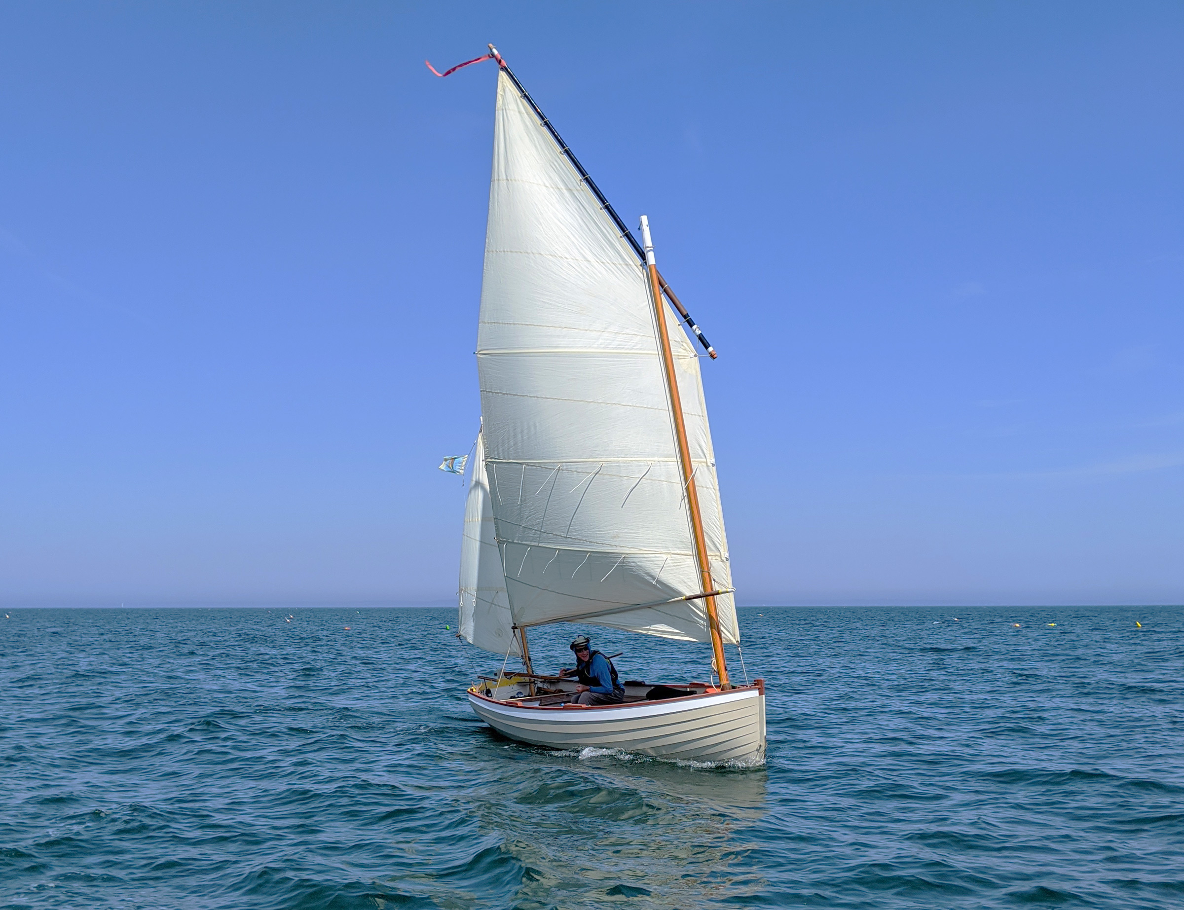
In the Sound, we sailed north through Ledbetter Narrows, which are only 120 yards wide and brooded over by a two-story 19th-century farmhouse with brilliant white walls. A mile and a half beyond, we approached the Sugar Loaves, two conical, burnt-ochre towers of rock wispy with thin patches of faded, salt-burned grass and standing proud over the entrance of Fox Islands Thorofare. The wind continued to increase as the day warmed and, setting our sails wing-on-wing, we increased our speed. I sat in the bottom of MUSSELS and listened to the water chuckling on the lapstrake hull become a constant rush. Watercraft traffic started to pick up, with motorized pleasure craft outnumbering lobsterboats. As we came around the curve of the Thorofare, North Haven Harbor came into view.
 John Hartmann
On a downwind run, MUSSELS made easy work of Fox Island Thorofare en route to the harbor at North Haven.
Cluttered with recreational and commercial boats alike, the village of North Haven seemed like a city. Zodiacs whined back and forth across the Thorofare, club sailboats were making sail, and larger boats making the east–west transit through the Havens were pushing rolling wakes. John and I stayed south from the main channel, held our tongues as one power cruiser steamed ahead in displacement trim and gave us a rocking, bantered with the sailors in the club sailboats, and soon left the harbor behind us with relief. On the east side of the Thorofare, the wind filled in from the east. We gradually sheeted in our sails until we were sailing upwind, tacking tightly around Widow Island, and headed southeast for Seal Bay, 2 miles away.
 Christophe Matson
After our long ghosting through the east side of the Fox Island Thorofare, John and WAXWING sailed upwind toward Seal Bay in East Penobscot Bay in a welcome breeze.
Hen Islands, half a mile away, marked the east side of the only deepwater entrance into Seal Bay. Under full sail, MUSSELS’ gunwale was pressed against the surface of the water, but I decided to forgo reefing. John was behind me and an outboard skiff with a family aboard pulled alongside him. The two children clung to the sides of the skiff and watched John as he hiked out and clawed WAXWING upwind. Wings of gossamer spray erupted with every plunge of his bow into the water. The skipper of the skiff gave John a thumbs-up and peeled away toward North Haven.
It was now late afternoon, and the tide was almost high. A sandbar connects the small islands that make up the Little Hens, and in a pocket cove created by it we would be protected from the southerly and could stop for a much-needed snack. Every 10 minutes a sailboat or recreational trawler would enter Seal Bay through the deepwater entrance on the west side of Little Hen, all under power. In the midst of the traffic, John and I tacked back and forth along the channel attempting to make way to where we wanted to drop anchor. John was a few hundred yards behind me. On my last tack, I scraped around the boulder just north of the sandbar and pulled into the 100’-long anchorage. I dropped my anchor into the clear waters with the white shell bottom glowing brightly underneath.
The wind here was but a light touch on the cheek and the sun overcame whatever sea chill I had felt working to windward. I went for a quick swim, and John pulled in next to MUSSELS.
In a few hours, the place we had anchored would be all sand and mud flats and we wanted something less exposed and protected for the night. We decided on a nook on the east side of Davids Island, a third of a mile to the south. The shores of the island were steep, rocky, and backed by close stands of trees and the descending sun silhouetted the jagged profile of the forest. I sailed deeper into Seal Bay, and approached our anchorage from the south. Wing-on-wing she galloped north over the shallow mud bar that lay in the shadowed 30-yard-wide gap between Davids Island and Little Smith. John was waiting for me with cold beer in a well-protected anchorage ringed with tall sharp-tipped spruce trees that formed a wall around us. I set my anchor into 15’ of milky, jade-green water and caught the bottle that John lobbed from WAXWING. A dusky-blue wall of twilight rose up from the eastern horizon and night fell quickly. Through the dark, scattered gunshots and the staccato exhaust of ATVs somewhere in Vinalhaven’s backwoods rang out over the calm bay.
Up at dawn, we waited for the flood that would push us north. John was eager to show me Butter Island, a favorite location from his past journeys. It lay about 8 miles due north from our anchorage, and we were hoping for a good sea breeze to get us there, but after a tantalizing bit of sporty upwind sailing in 12 knots of breeze between Hen Island and the 20′-high cliffs of Bluff Head, the wind dropped to a whisper. We could still ghost along faster than we could row, so we settled down with towels draped over our legs and feet to protect them from the broiling sunlight.
The wind would fill the sails for a few minutes, fall away, then rise again. During a few of the moments of calm, I slipped over the rail to swim and escape the heat. Leaving MUSSELS to drift slowly, I dove down into the clear water stopping some 6′ from the surface to look up at the dark oval of my boat and the shimmering column of air bubbles I had trailed behind me. Over the course of three hours, in fits and starts, we made it to the pass between Fling Island—a ¼-mile-long oval of rock, meadows, and trees—and Eagle Island, its larger neighbor, ½ mile to the east. Finally, in the 1/2-mile-wide channel between Eagle and Butter islands, a steady breeze ruffled the water. At Butter’s southeast point, John and I were swept around The Nubble, a 50-yard-wide dome of pale granite rimmed with dark seaweed that looked like a medieval monk’s tonsure. We turned north into a cove sheltered by The Nubble and nudged the stems onto a ¼-mile-long crescent sandy beach studded with cobbles.
Butter is privately owned and to camp on the island requires permission, which we had not obtained; our plan was to spend the night at anchor just off the beach. Within minutes of our arrival we heard the soft sputter of an ATV in the woods lining the beach. A lanky man in a well-worn button-up shirt and sun hat strolled out from between the trees and introduced himself as the island steward. We asked if we could leave our boats on the high-tide line and sleep in them. He appreciated that we knew permission was required and granted our request. With that taken care of, he asked to take a look at our boats.
 Christophe Matson
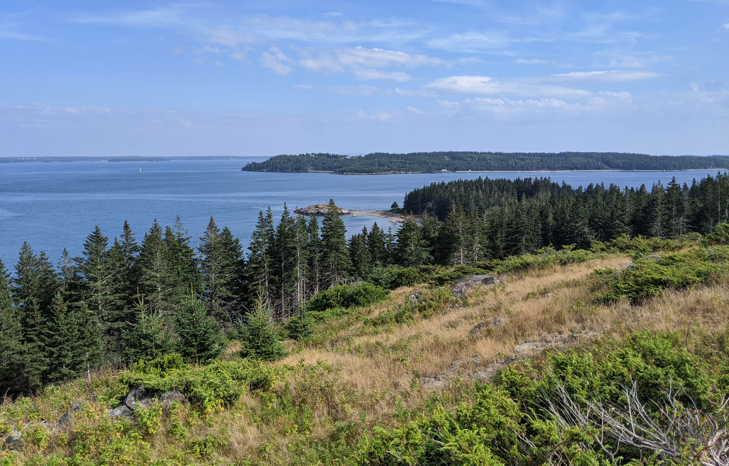
Looking south from the top of Monserrat Hill on Butter Island, John and I could see Eagle Island in the middle distance, Deer Isle on the horizon to the left, and, directly below, The Nubble and the beach where we anchored the boats, barely visible here. The expansive view was an abrupt shift from the previous three days of seeing everything from sea level.
We had two hours to high tide, so we set the boats on their anchors and then walked a soft, pine-needle-strewn island trail to Monserrat Hill, a 150′-tall, treeless point in the midst of golden grasslands dotted with low, gnarled shrubs. From the summit there was a commanding view over East Penobscot Bay. The undulating terrain of the islands filled Penobscot Bay to the west, with the Camden Hills poking out over the last wooded ridge. To the southeast, the 500′ summits of Isle au Haut were barely peeking over the top of Eagle Island, and North Haven was a wide, black band on the southern horizon. In the east, Deer Isle with its many coves lay its undulating flank open to us. At sea level, we had been focused on navigating from landing to lobster pot, cove to cliff, rock to bay, but here we were surrounded by sweeping perspectives of a coast studded with island jewels.
There is a memorial bench— a thick, curved slab of polished granite—dedicated to Thomas and Virginia Cabot, who bought the island in the 1940s to keep it available for public use. A bronze plaque, recessed in bare bedrock, bore a poem written by Thomas: “…I bid you sit and rest a bit, to count your share in worldly care…” Beyond the plaque, far below us, our two boats, tiny in the distance, lay at anchor, protected by The Nubble. After taking in the views, John and I headed down the trail to secure them on the high-tide line.
In the thick of the night, scattered lights glittered from between the trees on Deer Isle, 2 miles away across the bay, while the Milky Way carpeted the sky. I slept covered by my mosquito netting, without a fly cover, and through brief moments of wakefulness noted the drift of constellations across the sky. At some point deep in the night, I woke to a pair of voices, one high, one low, coming from what seemed miles away, singing an ethereal song that merged with the gentle lapping of the water on the cobbles. Hours later, when the sun rose blazing over Deer Isle, warming my face, I remembered nothing but fragments of a tune whispered on the breeze.
 John Hartmann
John and I both deployed our beaching legs for the overnight stay on Butter Island. I decided to forgo the tent fly and only used my mosquito net. At sunrise, we woke to a rising tide.
John and I readied the boats to get underway and departed the beach on Butter Island for the longest leg of the journey—the 13 miles back to Hurricane Sound and the entrance to The Basin. This would complete the circumnavigation of North Haven and put us back in a comfortable anchorage for the night. There was a fresh morning breeze between Eagle and Butter islands, and we skimmed off on a broad reach for Sloop Island, a touch over 2 miles away. Low-slung and wave-swept with a pocket stone beach on the east side, Sloop, little more than a chain of three grass-topped rock outcroppings, appeared to be an inviting place for lunch on a nice day, but not much else, so we skirted around the island’s south end. We took a bearing for Webster Head, a tall prominence on the northern point of North Haven and at that moment, the wind died completely, and the water flattened as if suddenly gelled. We stowed our rigs and rowed for North Haven and continued southwest down its coast, a series of unremarkable nameless points that left us wondering how far we had come and how far we had to go. Granite-gray beaches, all about ¼-mile long, were divided by blunt angles of layered rocks capped by broken stretches of forest 10’ up. Every few hundred yards we would get a brief glimpse between the trees of a solitary house before it would disappear, and another would show itself.
Eight miles and two hours after leaving Sloop, we arrived at a 1/8-mile gap in the shoreline, the entrance to Pulpit Harbor. We paused by Pulpit Rock, a 15′-tall, guano-streaked, lava-black crag guarding the harbor’s entrance, and discussed the prospect of lunch. The harbor looked enticing, with the sun playing on the water between lobsterboats and pleasure craft, but we decided to press on another 2 miles to Bartlett Harbor. The passage went a bit faster with a current now pushing us along, and landmarks were easier to identify— distinctive headlands and, cupped between them, beaches in various sizes and shapes that were easily matched to the chart. At Bartlett’s oblique, 1/4-mile-wide entrance, I came around a rocky spit that lay uncovered by the low tide and anchored in tight alongside a solitary column of stone that lay just under the surface. I noticed other interesting rock formations in the clear water and took the opportunity to snorkel a bit.
I slipped over the side of MUSSELS and found some skittish ruddy-brown Jonah crabs, a multitude of urchins, and, between rock walls, a few canyons just wide enough to swim through. After my brief explorations and my teeth beginning to chatter; I pulled back over the gunwale.
John had started to row his way out of the harbor and around the corner. As I took a few minutes to set things straight in my boat, I noticed that the tide had come up a fair bit and MUSSELS had swung closer to the reef. She was now over the ledge that I had laid her next to. A swell started to enter the harbor around the point and the boat began to heave up and down. The rudder, which had its blade kicked up, landed heavily on the rock column, which was now directly underneath the stern. I made my way forward to take in the rode and pull MUSSELS away, but I was too late; the rudder came sliding up out of the gudgeons and flopped over into the water. I stepped back to the stern to retrieve it, and fortunately the haul-up line was still cleated to the boat so the rudder didn’t wander off. The long tiller extension was awkwardly wrapped under the port side of the boat and pinned between the skeg and the reef; I needed to get out of the boat to extricate it. I stepped carefully over the starboard side onto the narrow ledge and wrestled with the heavy rudder’s long and awkward appendage. I noticed that the nylon bushing that fits in the gudgeon was at my feet, in thigh-deep water. Without it, the rudder can bind and, while I had spares in my tool kit, I didn’t want to get back into the boat for a replacement bushing and leave the rudder afloat and unattended. The swells continued to increase and with one hand fending off the boat, I dropped the rudder and attempted to dive between my knees for the bushing, but the boat came at me and her boomkin swept me into the deeper water behind me. I grabbed at the gunwale to keep myself from plunging down between rock walls and planting my bare feet on those sea urchins lurking below. MUSSELS swung back into the harbor and I landed again on the rocky perch. I gave the boat a good push outward and grabbed for the bushing while simultaneously making a wild grab for the rudder. Successful, all that remained now was to hold the bushing in place, precisely align the two pintles to the gudgeons and install the rudder, all the while furiously tap-dancing to save my feet from the skeg, which repeatedly slammed down on the rock. I leaned against the boomkin to keep MUSSELS held off, secured my feet, and then lifted the rudder to vertical. The pintles dropped into both gudgeons simultaneously, an incredible stroke of good luck. I clambered into the boat and rushed to the bow to pull MUSSELS forward before we could be forced to go through the entire act a second time. I energetically rowed away from the spit and as I came around the corner, I saw WAXWING. John, with a look of exasperation on his face, was gesturing with upward palms. We rowed on.
Two miles later we rounded Stand-In Point at the southwest end of North Haven and faced a daunting 1-1/2-mile crossing of Fox Islands Thorofare before we could get back to Ledbetter Narrows and Hurricane Sound. The Thorofare, a 7-mile east–west passage between North Haven and Vinalhaven, was congested with ferries, commercial boats, barges, and pleasure craft and the water was tumultuous with their wakes. The wind, finally appearing, was rising from the southwest at a paltry 5 to 8 knots. We raised sail and started our march across the Thorofare. The chaotic waves slammed the spars against the masts and did little to help our forward progress. John mixed in a combination of sailing and rowing, dropping and raising his rig. I had slightly more success sailing, keeping my sail lightly tensioned and using my body weight to heel MUSSELS to leeward so the weight of the spars could keep the sail from slatting. Slowly and painfully, we made it behind Dogfish Island and from there, with the wind suddenly nonexistent, we rowed into Hurricane Sound and made for Ram Island just outside the entrance to The Basin.
We could hear the dull rumble of water surging into The Basin—high tide was still a few hours away. We did not have the energy or focus to attempt to challenge the strong current, so we anchored in a 70’-wide cove between Ram and the spruce-tipped islet to its west. The holding ground was good and the bar that develops at low tide would protect us from swells that can come in from the south.
 Christophe Matson
At the end of our longest day—from Butter Island to Ram—John curled up with a drink on the warm ledge and checked the next day’s weather forecast. We were both spent and not up for anything but taking it easy.
John and I, exhausted by the rowing and rough crossing, climbed wearily onto the smooth, beige slabs of rock that ring the island and soaked in the warmth of the sunlight radiating from the stone. We cooked dinner together, a mix of Indian food and rice from a bag, and listened to the forecast for the following day. It called for light winds, not enough to assure an easy passage back to Rockland, and neither of us relished the idea of rowing the 11 miles, most of it an open-water passage, back to the mainland. We decided that we would wake early and ride the flood current into The Basin and take a day off, before sailing back to Rockland.
The next morning arrived bright and clear as we rowed effortlessly into The Basin at the end of the flood. Surprisingly, there was some nice early-morning wind inside the cove, and we raised sails and scooted around the islands on perfectly flat water. I looped some lazy-eights between two islands and then found a suitable anchorage between a ledge-lined island with round boulders scattered around it and islets that would be joined at low tide with jagged rocks. I dropped the hook in 20′ of water and choked the rode tight so MUSSELS wouldn’t swing too far and get high-sided when the tide went out. I made coffee and watched John in WAXWING poke around the cluster of islets and through narrow slots, cutting through the sun-speckled water.
 John Hartmann
Before heading back home, we spent a long day relaxing back in The Basin. John set up WAXWING’s cockpit with a break-apart camp chair and an umbrella for a cozy reading nook and spent the day lounging.
Soon, John dropped anchor nearby and settled into his morning routine. It was only 10 a.m. We idled away the day reading, sleeping, and swimming. John made some very welcome gin-and-tonics in the afternoon and we watched the sunset turn the ripple of clouds above our heads into brilliant gold and crimson that was reflected in the water around our boats.
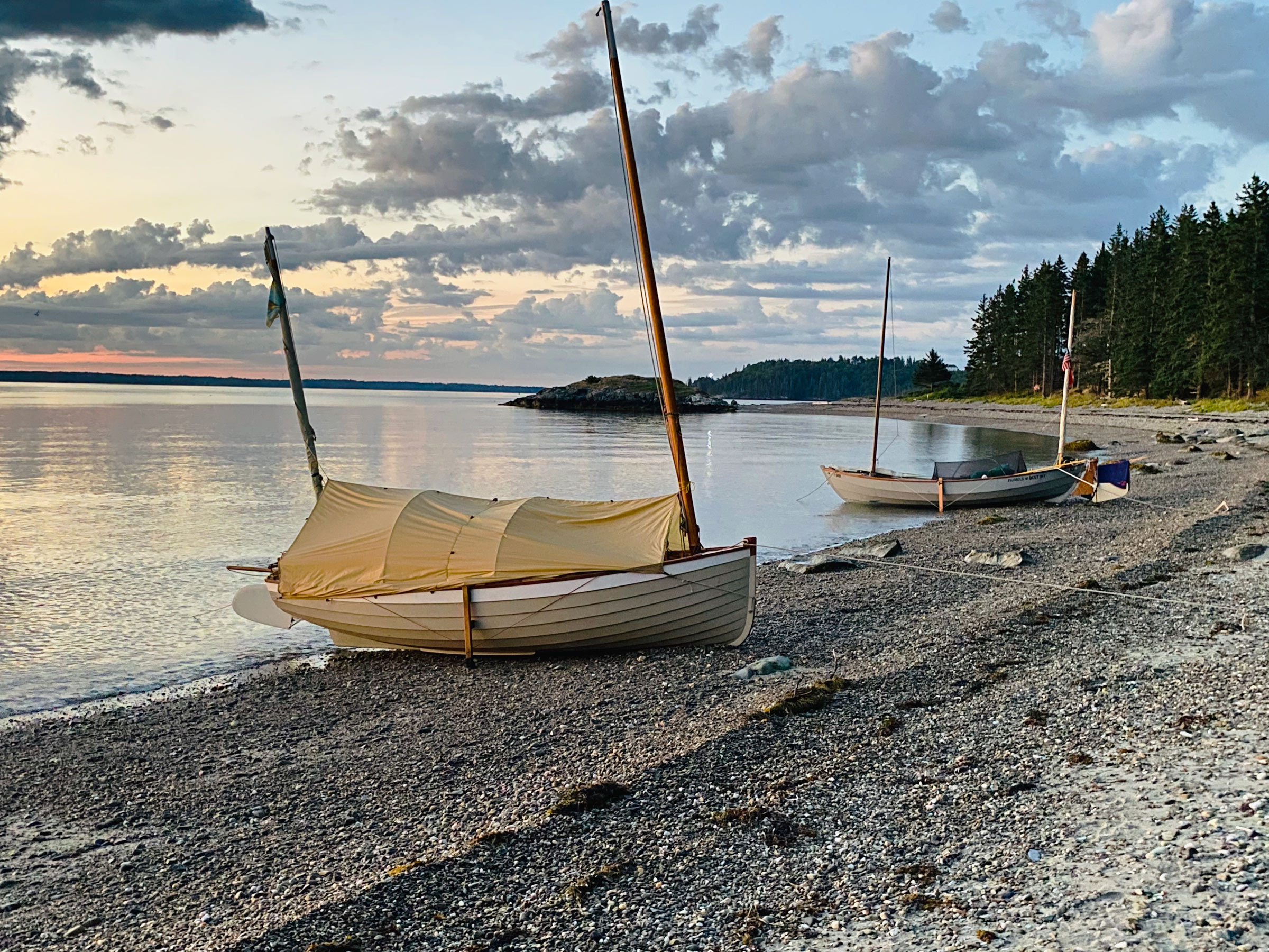
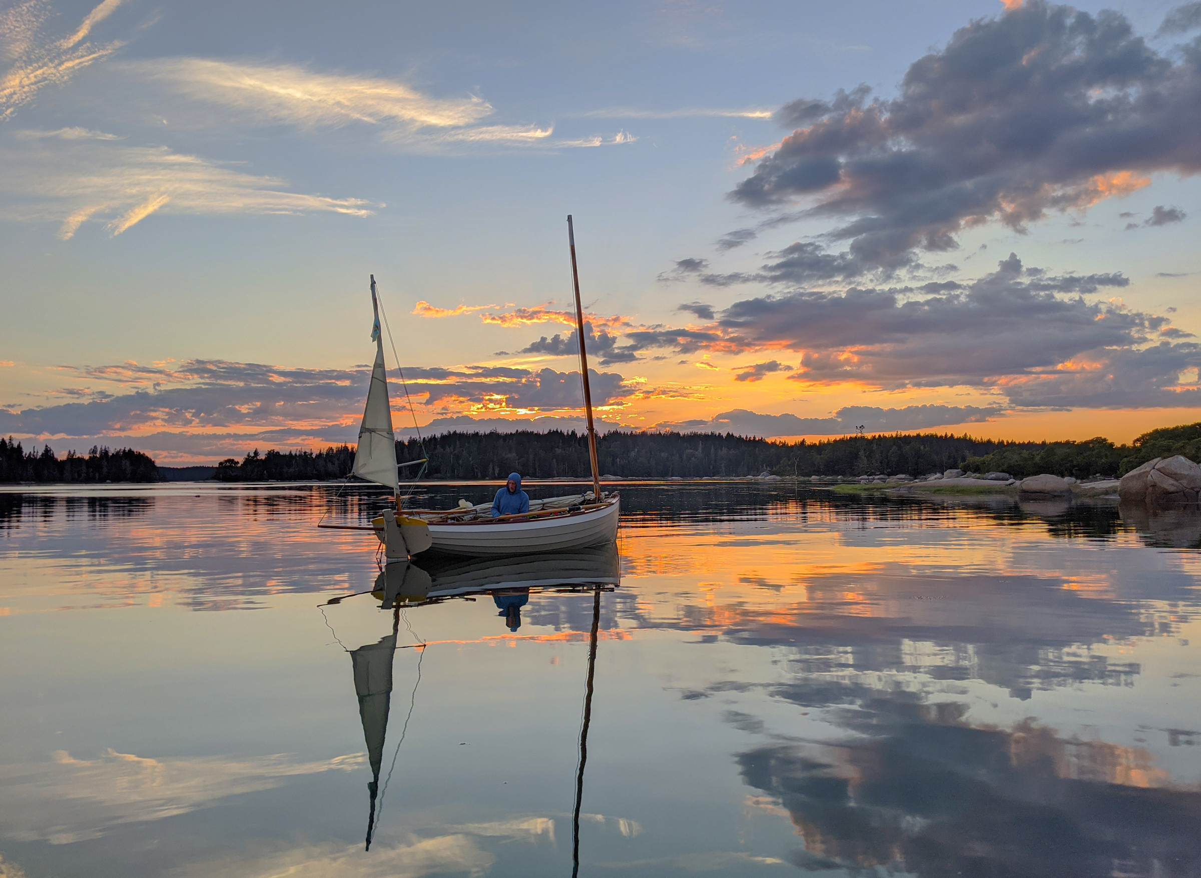 Christophe Matson
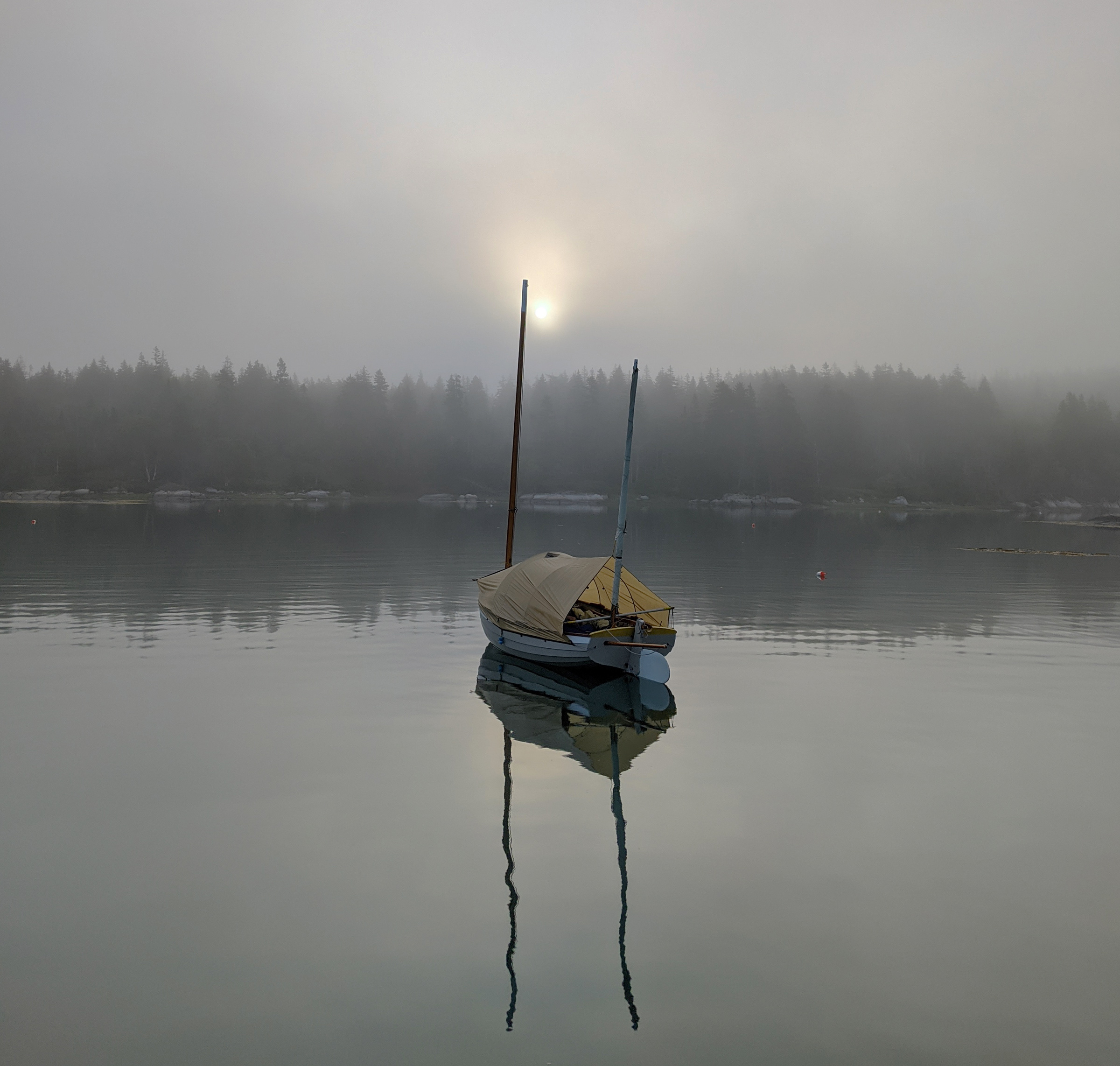
WAXWING hovered in the reflection of a brilliant sunset before our return home the next day. That night brought overcast skies and hard wind from the east.
During the night a sudden wall of wind from the east hit our boats. It was an uncommon direction and MUSSELS strained at her rode. I got up and let out a few extra feet of scope. The stars were gone, masked by an overcast sky. My bunk, laid high across the thwarts, left me exposed to the wind and, wrapped in my sleeping bag, I felt it buffeting my face. I dragged my pad and bag into the bottom of the boat and contorted myself between the centerboard trunk and side-bench uprights. There I uncomfortably waited for the gray dawn.
When we had enough light, John and I moved rapidly to get to the entrance of The Basin for the end of the ebb. As it was, The Basin was already emptying far faster than it had been at any previous time we’d seen it during our trip. We cautiously entered the northern branch of the exit, and as we drew closer to the current speeding toward the outcrop in the middle of the gap, we deployed our anchors. The boats quickly took up the slack and hung tight to their rodes. We studied the way the water curled around the outcrop and John, once a river guide in times long gone, took careful notice of where the water raised and dipped, where the eddies were located, where the traps could be, and where we should enter the main flow. He detailed the strategy to get our boats through safely: we would enter high using the eddy just east of the islet to draw us south to the main flow, taking care to stay in the central portion of the flow and not get drawn into the eddies along the sides or behind the boulder. John went first, taking hard strokes, pausing, then swinging upstream. He pulled for the main current. WAXWING shot bow first into the gap, descended the sluice, and in an instant disappeared behind the islet. I cinched my life jacket tight and pulled MUSSELS into John’s route. The large eddy played with the retracted rudder, and the tiller pulled and pushed me while I fought to compensate as the bow was forcefully drawn toward the exit. I threw myself into the oars to enter the main channel bow first and watched The Basin disappear astern behind the closing gates of rocks and trees. MUSSELS was swept down the rapid and shoved out into Hurricane Sound.
We pulled for a quarter of a mile into less turbulent water and raised sails. MUSSELS spread her wings with a velvety pop and we ran downwind across Hurricane Sound, around Ledbetter Island, through the Lawry Narrows, and out into the open water of Penobscot Bay. I aimed the bow toward a tiny block on the mainland horizon—a concrete grain tower marking the ramp on Rockland’s waterfront. To the east, Vinalhaven receded into a dark streak on the horizon under a rolling charcoal sky.![]()
Christophe Matson lives in New Hampshire. At a very young age he disobeyed his father and rowed the neighbor’s Dyer Dhow across the Connecticut River to the strange new lands on the other side. Ever since he has been hooked on the idea that a small boat offers the most freedom.
If you have an interesting story to tell about your adventures with a small boat, please email us a brief outline and a few photos.


The one picture reminds me of my grandfather’s admonition – “There are three things you should never carry on a pleasure boat: a step stool, an umbrella, and a naval officer.”
That’s good. I have to remember that! But, that means I can no longer sail with my two sons.
R
Are they step stools?
Well played, Andrew –
Great story! I have sailed midcoast Maine many times and find North Haven and Vinalhaven among the best. Hurricane Sound certainly lives up to its reputation as one of the best cruising grounds in Maine. Merchants Row, Swans Island, and others are also wonderful. A week to 10-day cruise around the area will just touch on what the archipelago has to offer. Hope to see you there sometime.
Christophe,
Many thanks for this! The trips you and John take are so much in the spirit of my own sailing. I sure hope we get to cross paths on the water at some point, so you can show me something about these “tides” I hear so much about…
Nice article, it really put me in the cockpit with you both. Cheers,
Tom
Wish we had a “thumbs up” we could click on these comments
Tom, this reminded me of your articles on sailing the North Channel, which are so well written!
One of the most beautiful photos we have ever seen! Nice report, thank you for sharing.
Cheers
Clark and Skipper
The sunset photo of WAXWING is an absolute treasure. Thanks for sharing it with us.
The Sunset and the photo at the top with the tides shadows on the rocks and what appears to be fog above, but could just be the header for the column?
Since I’m hoping to build an Ilur, I’ve had to keep a tissue near to deal with the drool.
Love John’s full-battoned lug sail
R
I now have an Ilur! hope to get an invite some day up there!
Highly enjoyable account of your trip. It’s one I’d like to to someday. Which ramp did you use in Rockland?
David,
I have to, regrettably, correct John, who answered below. We launched from the Snow Marine Park just south of town.
Be ready for the crossing to the Havens, which can be long and unpredictable. Once you make it to the islands there are lots of hiding holes to ride out bad weather. Looping either island or more has much to offer and the place becomes a world unto itself. When we pointed our bows back to the fuzzy mainland on the horizon I was reminded we were out-to-sea. I had this feeling on both trips, it makes the weekend warrior in me feel accomplished!
Thank you so much. An amazing adventure and fantastic photographs.
David, we launched and took out from the public ramp at Harbor Park, on the south side of Crockett Point.
Great photos! Thanks for sharing.
Great trip! Sail-and-oar cruising with another boat or two is one of the best things that life has to offer.
I thought I was the only one to carry an umbrella, used for just the same purposes as John does. I have settled on carrying a golf umbrella. Made of composites, it doesn’t rust in the salt air, the vents keep it from being blown about quite so much and, being larger than a regular umbrella, you have more shade. In addition, if you go for a walk in the rain ashore, it keeps you drier that just your foulies. In an open boat, any time you have a chance to stay dry, it makes for a much more comfortable night once you have your boat tent set up.
Alex,
Umbrellas are definitely a thing with our cruising group as well. Check out the Swans Island trip in Small Boats, October 2020 for more sporty umbrella use.
I carry a trekking umbrella on my boats and use it regularly for much of the same reasons you specified. It keeps paying for itself at least every other trip. Nothing dries at night wallowing around at sea level. Staying dry is a priority for me, and as you mentioned, immeasurably increases comfort of camping aboard.
Ah, yes. I had read that article but had forgotten the picture of the umbrella deployed as an underway bimini.
Putting my Maine Island Trail Monitor Skipper hat on, this basically follows my regular beat. For those who want to go ashore or camp ashore there are plenty of islands, MITA islands, and some that are under the purview of the Maine Coast Heritage Trust, and with the barrier of a longish open water run over from Rockland, not real crowded. Christophe didn’t mention it, but you can stop in North Haven for ice cream. Right in the heart of lobster grounds which can be bought from a boat if you brought a pot. The Basin is magic with something like 90% of the land surrounding it in conservation; if your timing doesn’t work you can camp on Ram as well as sleep in boats.
I missed joining Christophe and John on this trip in RANTAN, my oar-and-sail boat; just have to do it another time.
Thanks for an amazing article and great photos. I’m inspired 🙂
I’m finishing a refit and overhaul on a 17′ traditional, riveted Whitehall. I have a sprit rig set up, and a good set of oars, and looking forward to a few Pacific Northwest adventures this summer.
I noticed the hull “props” on both of your boats in the photo of the two boats beached on Butter Island. I’ve never seen those. Can you tell me more about them? Brilliant idea, and I’m not sure how I’ve missed learning about these.
Both Christophe and John equipped their boats with beaching legs to allow their round-bottom bots to sit upright when aground between tides. Our article, “Beaching Legs,” in the November 2014 issue will provide you with some guidance on making a set for your Whitehall. In the article there are photos of beaching legs I made for my traditionally built Whitehall.
—Ed.
Christophe, great article. How would you compare your Sea Pearl to the Caledonia Yawl ?
Thanks
Donald,
If you head over at my “Swan’s Island” article in October 2020 I answer a very similar question asked by Caleb as to how the Caledonia compared to the Sea Pearl and the Ilur. In short I find that the Sea Pearl, in my opinion and experience, is the better sailing boat. It handles better and also points a bit higher, but this may not be a totally fair comparison as I have an underperforming centerboard in the Caledonia. The Caledonia Yawl is much drier, and with much more internal volume, is more comfortable for camping aboard over long periods. I also appreciate how the Caledonia will only capsize while the Sea Pearl will turtle if knocked down. Both boat speeds are commensurate. Also, not sailing related but still important, both tow about the same, though the Caledonia needs side-view mirror extenders if towing with a compact car.
John, any chance that chair of yours is still being made? Love how it fits and I’m wondering if you ever sailed sitting in it with the tiller over your shoulder? Can you direct me to where I might be lucky to find one? It is perfect for the ILUR.
Thanks
John Hartmann identified the chair as a Pangean Lounger from Byer of Maine. The company has it currently listed as sold out. John noted: “I haven’t sailed whilst seated in it, finding that in mild enough conditions for that kind of sailing, seated directly on the cockpit sole with a cushion for my bum, leaning back against the aft bench, with feet up on the opposite bench top is the way to go.”
UPDATE 6/15/21: Byer and Amazon now have the chair in stock, priced at $49.—Ed.
What a great read Christophe, describing the Maine adventure you and John had. Makes me a bit “Maine-sick” as I read it here in the Pacific Northwest. But I will try to have similar adventures in my small boats among the San Juans.
Fair winds