The French love sailing, but the big and expensive racing and cruising yachts often get all of the attention. Two years ago I got together with a group of friends and we organized a new event, called Challenge Naviguer Léger, Sailing Light Challenge, an unsupported, 100-mile tour along France’s Bay of Biscay coast in small boats under sail and oar.
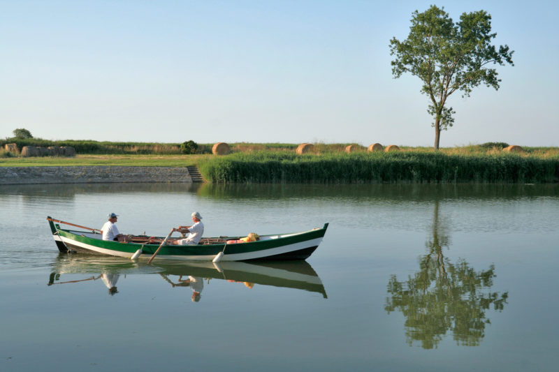
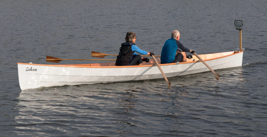
This year’s participants and I arrived at the Corps de Garde harbor near Charron, and waited with our gear-laden boats for the ebb tide to give us a favorable current down the Sevre River to its mouth at Aiguillon Bay. Almost all of the 15 boats being launched for the journey were open boats rigged for oar and sail. I wasn’t sailing; I’d be shepherding the fleet aboard our safety boat, a 17′ rigid inflatable boat (RIB) with a 50-hp outboard.
The waters of the Charente Maritime, located on the French Atlantic coast halfway between Britanny and Basque territory, are mostly shallow, and for the next four days, the tides would set a strict schedule for our travels. A lot of the stops we’d make were on shores that are inaccessible during low tides. Some of the marinas in the area even have locks to keep them from running dry as the ebb pulls the water back a mile or more from shore. While our route was protected from the Atlantic Ocean by Ré and Oléron islands, each about 16 miles long, the waters between them, Breton Strait and the Strait of Antioche, can be quite choppy.
 photographs by the author
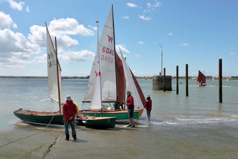
The 2016 Challenge began on the tidal reaches of the Sèvre River, which winds to the sea through the farmlands of Marans on the west coast of France.
When the high slack tide brought the Sèvre River to a standstill, we launched the boats. Carried by the quickening flow of the ebb we followed twists and turns of the river and dodged dozens of idle oyster barges anchored midstream. The wind was blowing from the east, as it usually does in the morning, so everyone had their sails set, taking advantage of the cool air that was sweeping across the farmlands to the Atlantic Ocean 24 miles to the west. We reached the buoy marking the mouth of the river and entered Aiguillon Bay, a 4-mile-wide apostrophe of shallow water tucked into the coast. At low tide it would be a vast expanse of mud, with the river’s channel through it widening as it approaches Breton Strait.
We set a course southwest for the Isle of Ré, about 11 miles away. The difference in speed between the boats spread the fleet out as we traversed Aiguillon Bay. LILI and EMJO 2, the two largest boats of the fleet, each 20′ long, were the first to first pass the concrete navigational tower at the mouth of the river channel, 3-1/2 nautical miles from shore. WHIMBREL, a Wayfarer dinghy, and FOXY LADY, an ultralight coastal trekker prototype, followed closely behind. This group of four would cross the finish line first every day of the challenge. The rest of the fleet, fanned out on their separate tacks, passed the tower one by one.
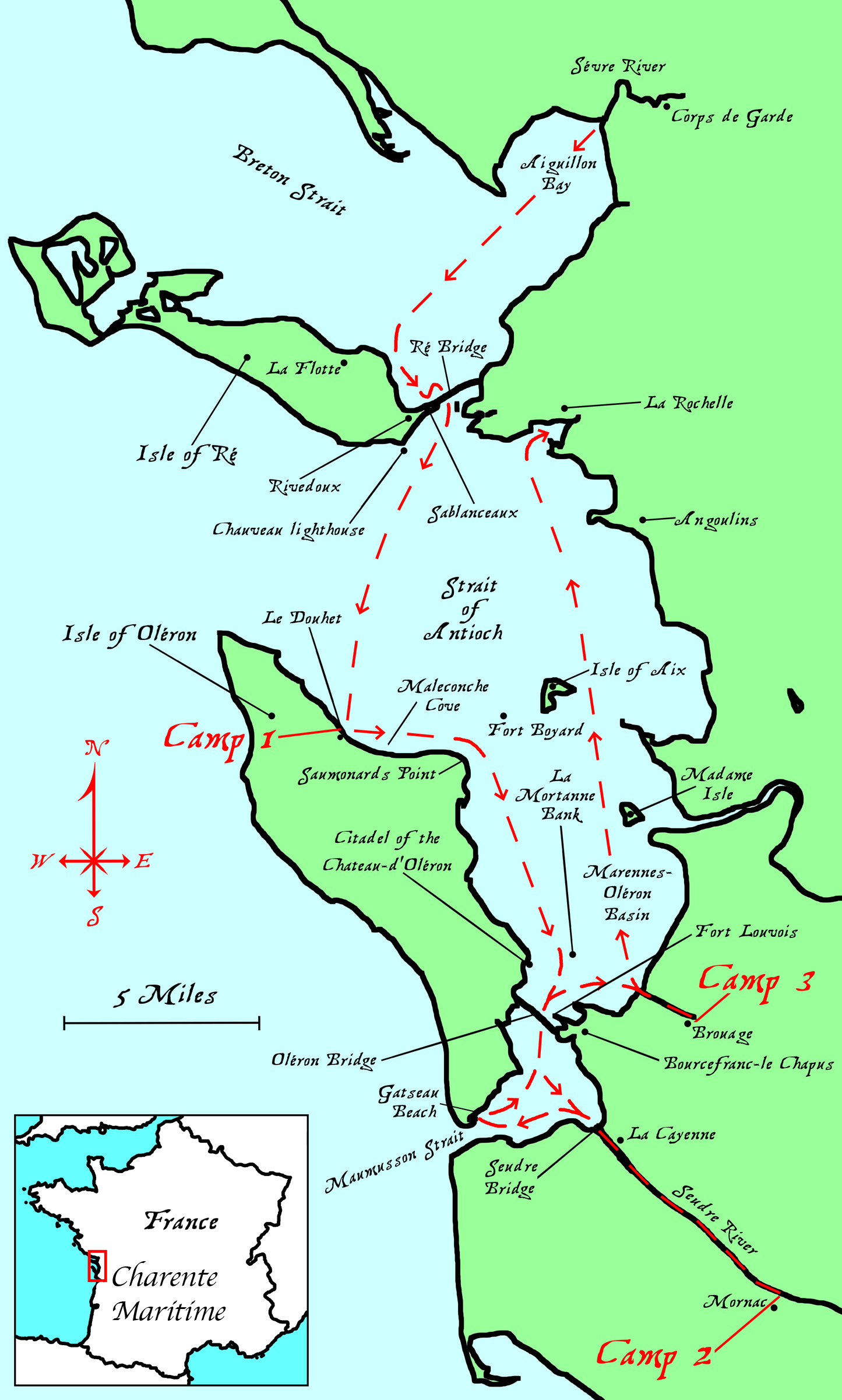 Roger Siebert
Charente Maritime
As we approached Ré’s east coast, we began to make out two streaks of tightly packed buildings with whitewashed walls and terra-cotta tile roofs—the towns of La Flotte and Rivedoux—separated by cream-colored, banded cliffs beneath verdant forests and farmlands. We veered south along the island’s east coast toward Sablanceaux Beach at the island’s easternmost extremity. The Ré bridge, a scalloped line of arched concrete spans, sweeps up from the island there and links it to the mainland with a 2-mile-long colonnade of eight-sided piers.
We stopped, as planned, at Sablanceaux to regroup, but the swell from the northeast waves came tumbling across the shallows. I was tempted to beach my boat but decided to anchor a few yards out from the breaking waves. The waves were not big enough to make landing dangerous, so several other boats did go ashore.
About an hour later, when we were ready to depart, the increasing swell made getting off the beach much more difficult for many of the boats. WHIMBREL and TOURNEPIERRE, an Ilur designed by François Vivier, both got through the shore-break, but sand and seashells churned up by the waves jammed their centerboards. With a lot of jostling, Emmanuel managed get TOURNEPIERRE’s board down again; WHIMBREL’s board remained jammed in spite of Stéphane’s best efforts. I took him in tow behind the RIB and our fleet set sail, passed under the bridge, and headed south toward the Isle of Oléron.
In the straits, the chop can make crossings a rough and wet ride.
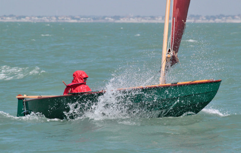
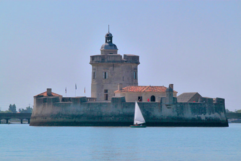
Nearly 3/4 mile beyond the Isle of Ré we passed the Chauveau lighthouse, a round red-and-white tower at the edge of the tide flats; the waves became steeper and whitecaps streaked across the Strait of Antioche. The northwest wind, as usual here for a summer day, was building and could easily reach 15 to 20 knots. For most of the boats in the fleet, it was time to put in a reef for the 10-mile crossing to Oléron. Our course for the last but longest leg of the day was a close reach, taking the waves on the starboard bow, and many of the boats were shipping a lot of water. Most of us had to do some bailing but we all had drybags and watertight compartments to keep our gear dry. The fleet stayed much closer together than it had in the light morning winds, keeping an eye on each other and making good progress toward a harbor located on a sparsely populated part of the north coast of Oléron.
After four hours of sailing, we were all wet with spray and tired but the fleet had made the crossing without incident and we arrived together just offshore from the harbor. The surf on the shore was much too high to make landfall on the beach as we had planned, so we had to make our way into the harbor. Its entrance channel was well marked by green and red buoys but quite narrow. On either side the water was quite shallow and glowing in the tawny light reflected off the sandy bottom. The channel takes a sharp, almost 90-degree curve to the west and led us between stone breakwaters set just 60′ apart. Having made the turn, the fleet was head-to-wind but had no room for tacking, so everyone had to switch quickly from sails to oars. All the while, the waves around us were crashing on the large rocks at the harbor entrance.
The transition to oars was effortless for ATYPIK, Pierre’s Chester yawl that he had modified by installing a small sailboard rig with a rotating carbon-fiber mast, and outriggers with gated locks. It took him no time at all to get the sail wrapped snugly around the mast, and because he kept the oars in locks while he was sailing, he just had to swing the blades swung out of the bow to start rowing. Others with more conventional rigs had halyards to let go, sails to drop, and oars to retrieve—no easy task when sailing alone.
About 100 yards in from the ends of the breakwaters we reached the opening that leads to the harbor’s floating docks. We rowed through the gap, and over a wall submerged by the high tide. During the low tide the wall blocks the way in and out of the harbor, but holds back enough water to keep the boats afloat. Our flotilla found a safe berth for the boats and we hauled our camping gear across the parking lot to a lawn bordered by the beach on one side and a four-tiered, white house that looked like a the superstructure of a mid 20th-century ocean liner on the other. With our tents set up, we were soon asleep.
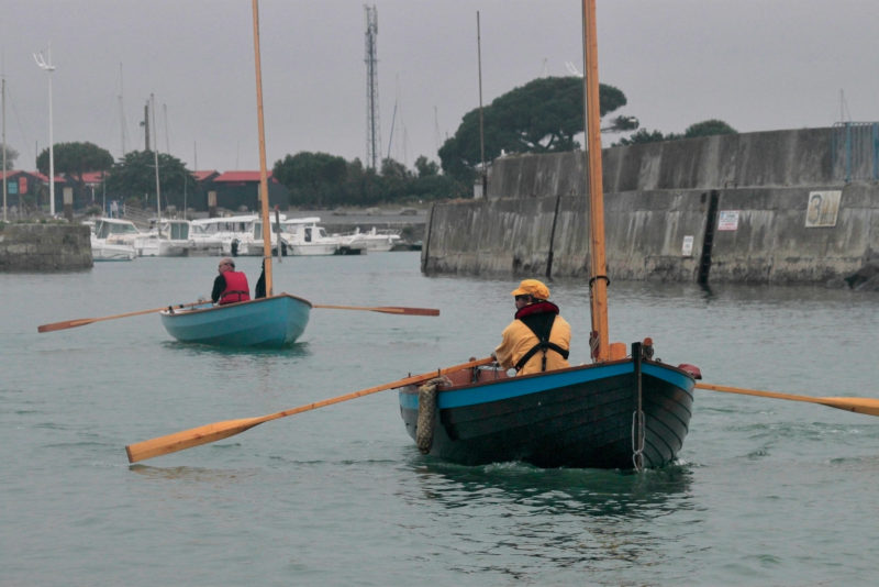
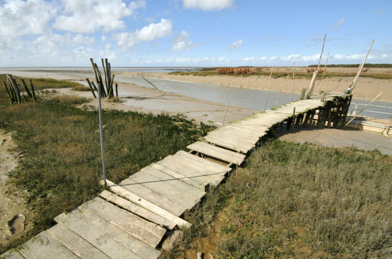
In a dead calm of the morning, the fleet rowed out the Douhet harbor channel on a high tide. As the tide ebbs here, the water in the channel will drop and expose a wall, submerged here, that will retain enough water in the harbor to keep the boats in the background afloat.
On Friday morning, we woke to a grey sky and light drizzle and made quick work of breakfast and packing our camping gear. At 8 a.m., the first boats left the dock, rowed through the gap in the breakwater and headed out through the channel. A light westerly breeze helped us sail downwind across Maleconche Cove where closely spaced 50-yard-long rows of wire oyster cages were suspended from shore-side pilings for nearly two miles. Oystering is one of the main fisheries in the region and oyster farms such as this one create a landscape in the intertidal zones equivalent to a farmland’s fields and furrows.
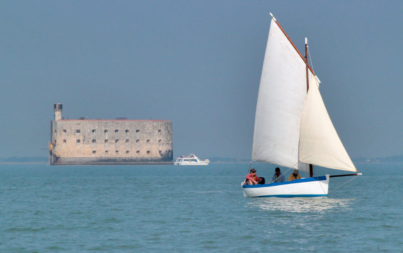
It took more than 60 years to build the Boyard fortress, and it was never used for the military purpose it was intended for.
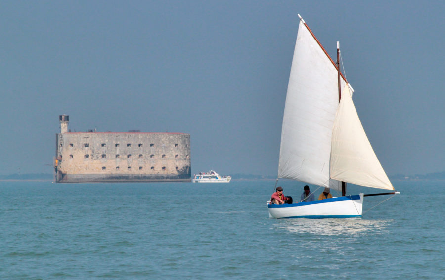
As we rounded Saumonards point to starboard, we could see Boyard fortress perched on the horizon to port. The four-story stone fort sits on a shoal halfway between Oléron and the Isle of Aix. Construction of the 220′ by 100′ oval fort was begun in 1801 during the reign of Napoleon Bonaparte, but by the time it was finished in 1837, the range of cannons had increased and the fort was no longer needed guard the 3-mile-wide straight between the two islands.
The tidal current was slowly but surely building up, bringing out a lot of bass fishermen in small motorboats. Our fleet was widely spread among oyster beds that outline most of the region’s coastline. We sailed along the passage between Oléron and the mainland from one navigational marker to an other; each three-tiered concrete tower had its name painted on it in tall, black, block letters: ARCEAU, LAMOUROUX, and JULIARD.
The current running northward against us grew stronger as we approached the narrowest part of the strait between Oléron and the mainland peninsula of Bourcefranc-le-Chapus. Before we were brought to a standstill we all anchored along La Mortanne bank, a sandbar bordering the deep-water channel on its south side and surrounded everywhere else by rows of oyster cages. To the west of us, a mile away on Oléron, was the Citadel of the Château d’Oléron, a 17th-century fortification with two sharp-edged bastions jutting into the strait like the bows of ships.
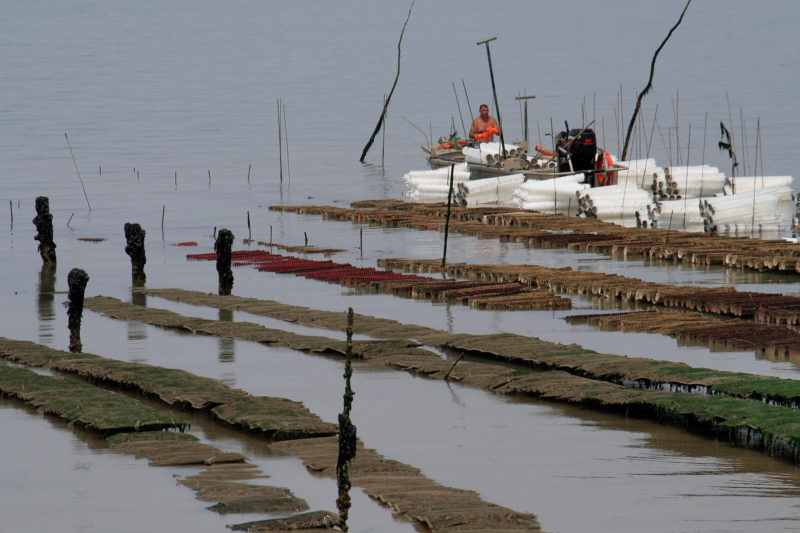
Charente Maritime waters are the most important place in Europe for oyster and mussel farming.
While we waited for the current to subside and reverse with the turn of the tide, I had a good long lunch as the ebb uncovered the oyster cages. As soon as the cages broke the surface, oystermen began harvesting the oysters and loading them onto aluminum outboard-powered barges. The heavily laden boats then skimmed along at 20 knots back to the harbor at Château d’Oléron.
When the slack arrived we pulled our anchors aboard. During the two hours we had spent waiting at the bank, what had been a light breeze was now blowing harder, around 15 knots and gusting to 20. Just as we were setting sail, PLÉNITUDE, a 16′ sharpie, was just rounding La Mortanne bank a full two hours after the fleet front runners had arrived. By far the slowest boat of the group, especially sailing upwind, PLÉNITUDE was always struggling to finish the legs in time to take advantage of the tides.
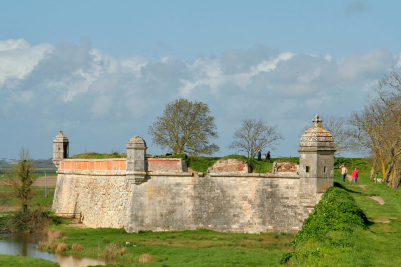
With the tide and a Force-5 wind behind us, we flew along a muddy channel dodging oyster beds, steel stakes, and oyster barges. We rounded Fort Louvois, a small horseshoe-shaped fortress with its toe poking out into the strait and a single tower rising at its back. It was built for Louis XIV in the late 17th century and sits on an island a quarter mile beyond a narrow peninsula on the mainland side. Soon after leaving the fort astern we passed under the slightly curved, concrete girders of the 1-3/4-mile-long Orléon bridge.
Now privately owned, the Louvois fortress was built at the end of the 17th century as part of a coastal defense system devised by Vauban, a famous military engineer working for King Louis XIV.
With a strong wind and current pushing us along at a good clip, we needed to turn east from the main channel into the mouth of the Seudre River, and we’d get only one chance to find the river channel make our turn at its entrance. If we were to miss it, turning back against wind and tide would be close to impossible.
We were able to make the turn with the fleet intact and sailed east under the bridge spanning the mouth of the Seudre. The river runs in a nearly straight line to the southeast, so with the wind and the current again at our sterns, we made good speed covering the 8 miles toward the channel that would lead us to the village of Mornac. I knew from previous trips that the entrance was narrow and very difficult to find. I looked very closely at all of the channels dividing the riverbank to starboard and fortunately, a sign—MORNAC—had been nailed to the top of two pilings crossed in a tall X. Just a few boat lengths in from the sign, the wind was gone and the waters were quite still. The fleet furled sails and took to the oars in a channel so narrow that blades often simultaneously touched the muddy banks both sides.
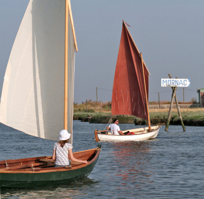
A sign guided the fleet into the tiny Mornac channel. Sails soon came down and the oars went out.
We looped through two oxbow bends, passed a long row of oyster shacks perched on stilts along the channel’s south bank, and nearly a mile in, arrived at Mornac, an old village of homes and shops with whitewashed stucco walls. The harbor was scarcely large enough to accommodate our fleet. Although we take pride in being self-sufficient, our Challenge rule of autonomy is meant to be broken now and again so we all sat down to a good meal at the local restaurant to recover from the strain of the day.
After dinner I put my tent on a small grass field on top of a channel bank. A steady western wind was blowing all night long, and I knew it would make our exit along the Seudre River quite difficult.
Early in the morning, I woke to an unwelcome Force-4 wind. We left Mornac and when we emerged from the little channel, the 100-yard wide stretch of the Seudre was waiting for us with an unpleasant 8 miles of choppy conditions and headwinds.
Once again, the varying windward abilities of our boats made a huge difference in our progress. Some set sail and tacked downriver, others chose to row against the wind to the river mouth. The fleet was soon spread all along the length of the Seudre, with PLÉNITUDE, as usual, trailing behind and gradually diminishing in the distance.
Near the mouth of Seudre river, the fleet regrouped at the large launch ramp at the little riverside village of La Cayenne.
A mile shy of the bridge at the river mouth we stopped at the harbor in the little village of La Cayenne to bring the fleet together. The westerly was now a mild Force 3, which would make our four-mile course to the south end of Oléron easier.
Emmanuel, a professional boatbuilder, had fitted a jiffy reefing system on his Grand Skerry. Here the fleet is beating toward the bridge spanning the mouth of the Seudre river. The bridge in the far distance connects Oléron Island to the mainland.
Together and under way once more, we zigzagged through acres of oyster beds and steel stakes to a sand bank situated at the 3/4-mile-wide mouth of Maumusson strait between Oléron and the mainland, waiting for the rising tide before sailing northeast to the entrance to a channel that would lead us to Gatseau beach. Turning west into the channel put us on a beam reach, a welcome relief after spending the whole morning working to windward. The beach, cradled in a cove surrounded by a forest of maritime pines, gave us plenty of room for the fleet to pull ashore. An hour later, after a good lunch and a rest, it was time to launch the boats, just as PLÉNITUDE, under her red sail, was arriving at the beach. Unfortunately for Jean-Bernard, builder, designer, and skipper of the boat, we had a schedule to keep us working with the tides and there was no time for him to come ashore. He brought PLÉNITUDE about and followed the fleet as we headed northeast on our way to Brouage, an old village on the mainland.
We passed back under the Oléron bridge and then rounded Fort Louvois once again to head east. The northwesterly wind was building up again as the day wore on. The frontrunners of the fleet were moving at a good pace across the waters of the Marennes-Oléron Basin and quickly closed in on the lone red buoy that shows the Brouage channel entrance. Beyond it, the only navigation marks along the path we had to follow were made of slender tree trunks, driven into the bottom and rising only a few feet above water level. We had to take care to keep at the right distance from the markers because water around is quite shallow even at high tide, barely deep enough for centerboards. The 2-1/2-mile-long channel is a large stretch of muddy water on a strange twisting course up to the coast, even heading back out to sea before finally reaching land.
At low tide, the Brouage channel is surrounded by soft slippery mud. It meanders meanders for 2 1/2 miles from the deep water of the Marennes-Oléron Basin and then winds another 1 3/4 miles to the village of Brouage.
Running the 25-yard wide waterway with the wind and being helped by a strong fair tidal stream, we sped by oystermen’s huts and dozens of docks, all on the right bank of the channel. The low land did little to shield us from the wind and we were going too fast for such a narrow stretch of water with small working boats moored very close by on the starboard side. Sails came down and the fleet took to the oars for the last 1-1/2 miles of the day. Brouage’s tiny harbor, if it could be called that, is nothing more than a long sloped bank along a road. We ran all of the boats aground there, side by side; the channel would empty completely at low tide and leave a bottom exposed, entirely covered by a thick layer of sticky mud. That evening, with official permission from the town, we set up our tents nearby on the grounds of an old oyster farm.
During 14th century, Brouage was an important commercial harbor with more than 200 ships moored around it. The sea has long since retreated, leaving the fortress town over 1-1/2 miles inland.
The next morning, while we were waiting for the tide to rise, I took a 15-minute walk around the fortified village of Brouage, which was established in 1555 and was the birthplace of Samuel Champlain, founder of Quebec City in Canada. The village is surrounded by ramparts built between 1569 and 1575 to protect the wealth accumulated by the local salt industry. During the 17th century, sea level began to lower, leaving the fortress like a stone ship lost in the salt marshes.
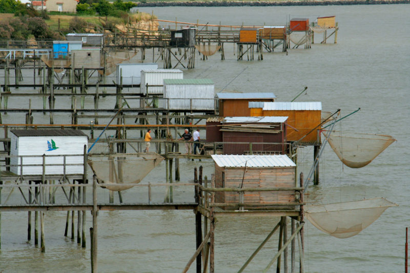
Sections of the Marennes-Oléron Basin coast are fringed with carrelets, fishing shacks equipped with nets and winches. The nets are lowered into the water, left on the bottom for a while, and then raised quickly to catch any fish that have gathered over them.
At 9:30 a.m. we started the last leg of the Sailing Light Challenge by rowing 1 1/2 miles back out to the Marennes-Oléron Basin. The tide was in, but the channel across the muddy shoals was still the only place deep enough for the fleet to sail. Some boats short-tacked into the wind between the tree-trunk markers in a channel only 20 yards wide. For boats with poor windward abilities and slow to come about it was hard work; the few boats being rowed also made slow progress.
The northwest wind was light at first, but as usual, slowly and surely it built up, as the sun warmed the land, pulling air in from the Atlantic. Waves grew as the wind strengthened and by late afternoon our boats were pounding upwind in a very choppy sea and Force-4 to Force-5 breeze. It was time to reef and to have a quick hand on the tiller if we were going to reach our final destination, the marina at La Rochelle.
On board YOUKOU LILI, Jean-Michel learned about prudent reefing the hard way. Ten miles into the last day’s passage he capsized just off the north coast of the Isle of Aix when he was carrying too much sail and a wave bigger and steeper than the rest knocked him over near a huge field of mussel aquaculture lines and floats. He climbed onto the daggerboard, righted his boat, and got back aboard into a hull full of water, but the bucket he needed for bailing had only been trapped under the thwart, not tethered, and was now gone. A small hand bailer was all he had to empty endless gallons of water. While he was bailing, another big wave capsized YOUKOU LILI; Jean-Michel climbed on the daggerboard again, but his mast lacked flotation and his sails were partially submerged. Jean-Michel put more pressure on the daggerboard. Unfortunately it was made of plywood and not as strong as one made of solid timber, and it broke off flush with the hull. Jean-Michel dropped into the water and his boat rolled upside down. As it wallowed in the 4′ swell, the mast and its partner broke. He retrieved his anchor and set it to keep the boat from drifting into the mussel field. With his boat stabilized, he climbed on the inverted hull and shot several flares to attract attention of the boaters around him. A powerboater nearby saw the signal, brought him on board and took him to La Rochelle marina, 9 miles to the north. I retrieved the YOUKOU LILI, righted and bailed her, then towed her to the marina.
Jean-Bernard was also fighting in the chop and trying to drive PLÉNITUDE upwind, taking a route closer to the mainland, just off the town of Angoulins. He hoped to find a safe haven there but missed the entrance of Angoulin’s haven, a small harbor on the peninsula that extends west from town. A strong gust broke his lugsail’s yard, so he dropped the sail, took the oars, and headed for shore. He landed on a small sand beach backed by Angoulin’s cliffs and pulled PLÉNITUDE ashore. For him, the Sailing Light Challenge was finished. He found a safe place to leave his boat until he could bring his car and trailer from the Corps de Garde launch ramp. The rest of the fleet made it safely to La Rochelle, and we gathered in the La Rochelle marina.
All of us were enthusiastic about the cruise, both for the times we enjoyed and the times that gave us things to think about and improve upon. We decided upon some new standards for next year. The boats must meet minimum standards for speed to make it easier for the group to keep together; gear and flotation must be securely stowed to provide a better measure of safety in the event of a capsize. Small boats are still the best means of traveling the French coast and there are more bays, forts, villages, and channels for us to explore. The Glenan archipelago in South Brittany and the Chausey Islands in Normandy are beautiful playgrounds we’re considering for the next Sailing Light Challenge.![]()
Jean-Yves Poirier is a dedicated amateur boatbuilder with 19 boats to his credit and a freelance writer working in France. He is a frequent contributor to WoodenBoat’s sister publication, Professional Boatbuilder.
If you have an interesting story to tell about your adventures with a small wooden boat, please email us a brief outline and a few photos.
Sounds like a great adventure. Small-boat cruising is a wonderful thing. I would love to see a picture of the Chester Yawl sail rig. I have often thought of trying to rig a sail on my Chester Yawl.
Wonderful area to sail small boats. Great article. I guess I have to put my little boat onto the trailer to sail there next summer. Not too far away from Germany, hmmmm…
Thanks a lot Jens. If you have any questions about the place, please ask!
Great pictures and sense of geography and history. More stories like this, please!
Great story, Jean-Yves! It would be good to learn more about the range of different boats used for this type of sail-and-oar cruising in France.
Thanks Alex, we are now in the process of organizing a new event around Glenan archipelago in South Brittany. Stay tuned!